First Published in 1993. Since before the dawn of recorded history the mountainous lands of the northern Middle East have been home to a distinct people whose cultural tradition is one of the most authentic and original in the world. Some vestiges of Kurdish life and culture can actually be traced back to burial rituals practiced over 50,000 years ago by people inhabiting the Shanidar Caves near Arbil in central Kurdistan. In this book, the author has tried to identify and delineate the heritage of the Kurds, now thoroughly submerged in the accepted and standard models for subdividing Middle Eastern civilization, none of which is designed to accommodate the stateless Kurds.
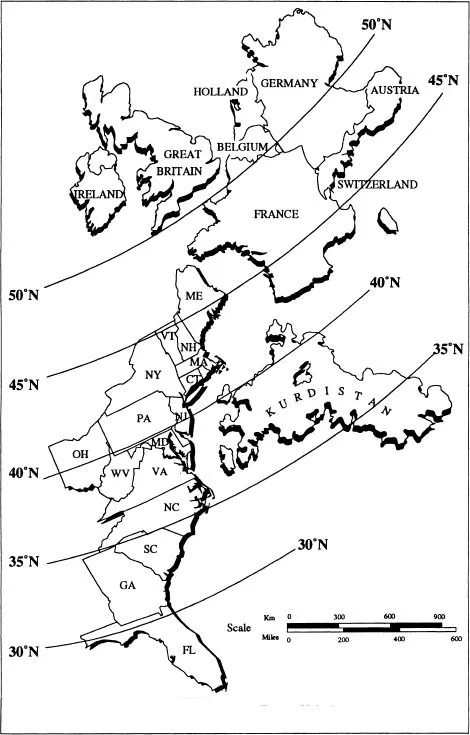
The vast Kurdish homeland consists of about 200,000 square miles of territory. Its area is roughly equal to that of France, or of the states of California and New York combined (see Map 1).
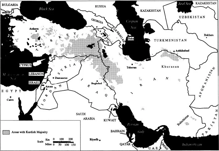
Kurdistan straddles the mountainous northern boundaries of the Middle East, separating the region from the former Soviet Union. It resembles an inverted letter V, with the joint pointing in the direction of the Caucasus and the arms toward the Mediterranean Sea and the Persian Gulf (Map 2).
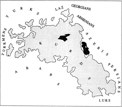
In the absence of an independent state, Kurdistan is defined as the areas in which Kurds constitute an ethnic majority today. Kurdish ethnic domains border strategically on the territories of the three other major ethnic groups of the Middle East: the Arabs to the south, the Persians to the east, and the Turks to the west. In addition to these primary ethnic neighbors, there are many smaller ethnic groups whose territories border those of the Kurds, such as the Georgians (including the Lâz) and the Armenians to the north, the Azeris to the northeast, the Lurs to the southeast, and the Turkmens to the southwest (Map 3).
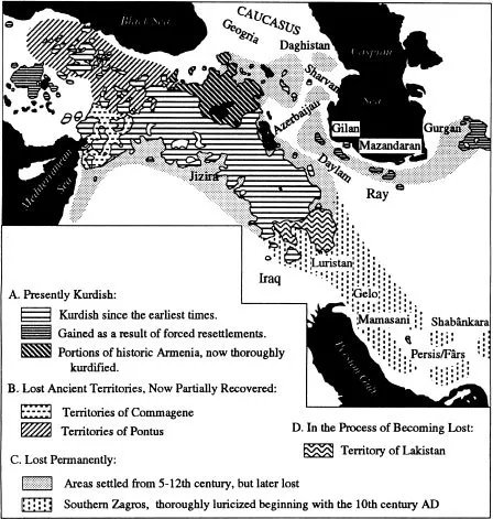
The range of lands in which Kurdish populations have predominated has, historically, fluctuated. Kurdish ethnic territorial domains have contracted as much as they have expanded, depending on the demographic, historical, and economic circumstances of given regions of Kurdistan (Map 4). A detailed analysis of migrations, deportations, and integration and assimilation is provided under Human Geography.
In the north of Kurdistan, Kurds now occupy almost half of what was traditionally the Armenian homeland, that is, the areas immediately around the shores and north of Lake Vân in modern Turkey. On the other hand, from the 9th to the 16th centuries, the western Kurdish lands of Pontus, Cappadocia, Commagene, and eastern Cilicia were gradually forfeited to the Byzantine Greeks, Syrian Aramaeans, and later the Turkmens and Turks. This last trend, however, has begun to reverse itself in the present century.
Vast areas of Kurdistan in the southern Zagros, stretching from the Kirmânshâh region to Shirâz (in Fârs/Pârs/Persis country) and beyond, have been gradually and permanently lost to the combination of the heavy northwestward emigration of Kurds and the ethnic metamorphosis of many Kurds into Lurs and others since the beginning of the 9th century AD. The assimilation process continues today and can, for example, be observed among the Laks, who, although they still speak a Kurdish dialect (see Laki) and practice a native Kurdish religion (see Yârsânism), have been more strongly associated with the neighboring Lurs than with other Kurds (Map 4). The distinction between the Kurds and their ethnic neighbors remains most blurred in southern Kurdistan in the area where they neighbor the Lurs, that is, on the Hamadân-Kirmânshâh-Ilâm axis.
Since the 16th century, contiguous Kurdistan has been augmented by two large, detached enclaves of (mainly deported) Kurds. The central Anatolian enclave includes the area around the towns of Yunak, Haymâna, and Cihanbeyli/Jihânbeyli, south of the Turkish capital of Ankara (the site of ancient Cappadocia). It extends into the mountainous districts of north-central Anatolia (the site of ancient Pontus), where it is bounded by the towns of Tokat, Yozgat, Çorum, and Âmâsyâ in the Yisilirmâq river basin. The fast-expanding north-central Anatolian segment of the enclave now has more Kurds than the older segment in central Anatolia. It is doubtful that, except for some very small Dimili-speaking pockets, this colony harbors any of the ancient Pontian Kurds who lived here until the Byzantine deportations of the 9th century.
Map 1. The Comparative Size of Western Europe, Eastern United States, and Contiguous Kurdistan.
The north Khurâsân enclave in eastern Iran is centered on the towns of Quchân and Bujnurd and came into existence primarily as a result of deportations and resettlements conducted from the 16th to the 18th centuries in Persia.
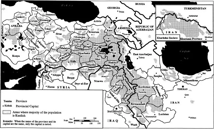
Since World War I, Kurdistan has been divided among five sovereign states (see Modern History), with the largest portions of Kurdish territory in Turkey (43%), followed by Iran (31%), Iraq (18%), Syria (6%), and the former Soviet Union (2%). These states have at various stages subdivided Kurdistan into a myriad of administrative units and provinces. Only in western Iran has the Kurdish historical name, even though corrupted, been preserved, in the province of “Kordestan,” with its capital at Sanandaj (Map 5).
A rather peculiar and confusing by-product of the division of Kurdistan among contending states and geopolitical power blocs (see Geopolitics) is its four time zones (five if Khurâsân in Turkmenistan is also counted). The continental United States, 15 times larger than Kurdistan, also has four time zones. Geographically, Kurdistan fits perfectly into one time zone, 3 hours ahead of Greenwich, England. The standard - 3 - hour time zone is defined as the area between 35 and 50 degrees east of Greenwich. With its western and eastern borders at, respectively, 36 and 49 degrees east, Kurdistan should naturally fall into a single time zone.
Plotting the Geographical Distribution of Kurds. Like many other aspects of their national existence and identity, the extent of the areas in which Kurds constitute the majority is the subject of dispute. While neighboring ethnic groups, in particular those in a ruling position, have consistently underestimated the extent of areas with a Kurdish majority, the Kurds have often tended to exaggerate them. This problem has naturally affected the works of non-local scholars as well.
Surprisingly, it is not difficult to plot the extent of Kurdish lands. There are plenty of old and new primary and reliable data available for such an attempt.
In the last century and the first half of the present, many trustworthy scholars and institutions have provided detailed lists of Kurdish tribes, their locations, distributions, and populations in various corners of Kurdistan (see Tribes). There were also attempts to plot these statistics and lists on maps: one of the best results was a large, multicolored British Royal Geographical Society ethnic map of this area, entitled Map of Eastern Turkey in Asia, Syria, and Western Persia (Ethnographical) (1906), which serendipitously is centered on Kurdistan. Few changes need be made today to this extremely valuable map, except of course to account for the obliteration of the Armenian ethnic element from around Lake Vân and other corners of eastern Anatolia as a result of World War I.
In the course of the 1960s, the Turkish government embarked on a project entitled Köy Envanter Etüdleri, or “village inventory studies,” which was later aborted and suppressed after 1967. Still, the “inventory” provided a great deal of information on the ethnic composition of Turkey down to the village level. In a data-packed work, Nestmann (in Ethnic Groups in the Republic of Turkey, P. Andrews, ed., 1989) provides a convincing ethnic map of Kurdistan in Turkey (excluding the central Anatolian enclave), utilizing the very same village inventory. The data in the inventory closely support the depictions of Anatolia in the 1906 British Royal Geographical Society map mentioned above. The only difference, and a surprising one, is that the inventory depicts the Kurdish ethnic domain as being even larger than on the British map. This may be an inadvertent reflection of the large-scale deportations and resettlements of Kurds within Turkey in 1929–38, and the relatively recent Kurdish demographic revolution (see Deportations & Forced Resettlements and Demography).
Map 2. Kurdistan in the Context of the Middle East
Map 3. Kurds and Their Ethnic Neighbors
The Iranian Armed Forces Geographical Bureau carried out a similar project in the 1940s, and the results appeared in the ten-volume Geographical Dictionary of Iran (A. Razmara, ed., 1949–1951). This was later supplemented by the Village Gazetteer of Iran (Iranian Statistical Center, 1968–present). The British colonial government of the Mandate of Iraq and the French in Syria (which included the Antioch district before its transfer to Turkey in 1938) provided sufficient data on the ethnic breakdown of those areas to refine the boundaries and extent of Kurdistan.
Russian maps created in the 1960s, utilizing just such primary data, also demarcate Kurdish regions, and have served ever since as models for others, including the U.S. Central Intelligence Agency’s published ethnic maps of the region. The best such Soviet material is found in the works of Bruk, Narody Peredney Azii (1960), with an accompanying sheet map at 1:5,000,000 scale, and Bruk and Apenchenko, Atlas Narodov Mira (1964). Both of these works also provide population figures for various segments of Kurdistan.
Maps provided for the present study have been based on these reliable sources.
Further Readings and Bibliography: Map of Eastern Turkey in Asia, Syria, and Western Persia (Ethnographical) (London: Royal Geographic Society, 1906, updated in 1914), with full-color sheet map at 1:2,000,000 scale; Ethnographische Karte der Türkei: Vilayet Darstellung der amtlichen TürkischenStatistik 1935 (Berlin: Presse E. Zagner, n.d.), with sheet map at 1:2,500,000 scale; S. I. Bruk and V. S. Apenchenko, Atlas Narodov Mira (Moscow: Academy of Science, 1964); S.I. Bruk, Narody Peredney Azii (Moscow: Ethnographical Institute, 1960), with sheet map at 1:5,000,000 scale; J. F. Bestor, “The Kurds of Iranian Baluchistan: A Regional Elite,” unpublished masters thesis, based on the author’s field work (Montreal: McGill University, 1979); W. Barthold, An Historical Geography of Iran (Princeton: Princeton University Press, 1984); G. Le Strange, The Lands of the Eastern Caliphate (London: Cass, 1966, reprint of the 1905 original); H.W. Hazard, Atlas of Islamic History (Princeton: Princeton University Press, 1951); L. Nestmann, “Die ethnische Differenzierung der Bevölkerung der Osttürkei in ihren sozialen Bezügen,” in Peter Andrews et al., Ethnic Groups in the Republic of Turkey (Wiesbaden: Reichert, 1989); Annual Abstract of Statistics, 1970 (Baghdad: Government of Iraq, 1971); Statistical Abstract 1973 (Damascus: Government of Syria, 1973); Population Census 1970 (Damascus: Government of Syria, 1972); Captain Bertram Dickinson. “Journeys in Kurdistan,” Geographical Journal 35 (1910), with map of Kurdistan at 1:2,000,000 scale; Captain F.R. Maunsell “Kurdistan,” Geographical Journal 3–2 (1894), with map at 1:3,000,000 scale; Captain F.R. Maunsell “Central Kurdistan,” Geographical Journal 18–2 (1894), with map at 1:1,000,000 scale; Lieut. Col. J. Shiel, “Notes on a Journey from Tabriz, through Kurdistan via Vân, Bitlis, Se’ert and Erbil, to Suleïmaniyeh, in July and August 1836,” Journal of the Royal Geographical Society 8 (1838), with map at 1:4,060,000 scale; T.F. Aristova and G.P. Vasil’yeva, “Kurds of the Turkmen SSR,” Central Asian Review 13–4 (1965).
Map 4. Major Territorial Fluctuations of Kurdish Ethnic Domains in the Past 3000 Years.
>
Map 5. Administrative Units of Contemporary Kurdistan
INTERNAL SUBDIVISIONS
Kurdistan can be divided historically, and on a socioeconomic, cultural, and political basis, into five major subdivisions: southern Kurdistan centered historically on the city of Kirmânshâh, central Kurdistan centered on Arbil, eastern Kurdistan centered on Mahâbâd, northern Kurdistan centered on Bâyazid, and western Kurdistan centered on Diyârbakir. The two large, detached Kurdish enclaves in Khurâsân and central Anatolia merit separate treatment (Map 6).
There exist “fossilized” records of two major historical subdivisions of Kurdistan, each following an epoch of ethnic homogenization. They have left their marks in the dialects spoken by the Kurds, their material culture, the elements of their religious beliefs, and their world outlook. Detailed analyses of the elements causing and/or fortifying the contemporary internal subdivisions, as well as the earlier ones, are found in the sections on Language, Religion, Urbanization & Urban Centers, Historical Migrations, and Deportations & Forced Resettlements.
A long episode of southeast-to-northwest migration of the Kurds culturally homogenized Kurdish society by the end of 3rd century AD. This homogeneity was subsequently diluted by a four-centuries-long separation of northern and western Kurdistan in Anatolia, which had come under the jurisdiction and/or influence of the Byzantines, from the rest of Kurdistan in the Muslim domains (see Medieval History). This ultimately resulted in the modern north-south split between the Kurmânji dialect groups, with the ...
Table of contents
Cover
Half Title
Title Page
Copyright Page
Table of Contents
List of Maps
List of Tables
List of Figures
Preface
Notes on Sources, Spelling and Other Observations
Acknowledgments
Chapter 1: GEOGRAPHY
Chapter 2: LAND & ENVIRONMENT
Chapter 3: HISTORY
Chapter 4: HUMAN GEOGRAPHY
Chapter 5: RELIGION
Chapter 6: LANGUAGE, LITERATURE, & PRESS
Chapter 7: SOCIETY
Chapter 8: POLITICAL AND CONTEMPORARY ISSUES
Chapter 9: ECONOMY
Chapter 10: CULTURE AND ARTS
Frequently asked questions
Yes, you can cancel anytime from the Subscription tab in your account settings on the Perlego website. Your subscription will stay active until the end of your current billing period. Learn how to cancel your subscription
No, books cannot be downloaded as external files, such as PDFs, for use outside of Perlego. However, you can download books within the Perlego app for offline reading on mobile or tablet. Learn how to download books offline
Perlego offers two plans: Essential and Complete
Essential is ideal for learners and professionals who enjoy exploring a wide range of subjects. Access the Essential Library with 800,000+ trusted titles and best-sellers across business, personal growth, and the humanities. Includes unlimited reading time and Standard Read Aloud voice.
Complete: Perfect for advanced learners and researchers needing full, unrestricted access. Unlock 1.4M+ books across hundreds of subjects, including academic and specialized titles. The Complete Plan also includes advanced features like Premium Read Aloud and Research Assistant.
Both plans are available with monthly, semester, or annual billing cycles.
We are an online textbook subscription service, where you can get access to an entire online library for less than the price of a single book per month. With over 1 million books across 990+ topics, we’ve got you covered! Learn about our mission
Look out for the read-aloud symbol on your next book to see if you can listen to it. The read-aloud tool reads text aloud for you, highlighting the text as it is being read. You can pause it, speed it up and slow it down. Learn more about Read Aloud
Yes! You can use the Perlego app on both iOS and Android devices to read anytime, anywhere — even offline. Perfect for commutes or when you’re on the go. Please note we cannot support devices running on iOS 13 and Android 7 or earlier. Learn more about using the app
Yes, you can access Kurds by Mehrdad Izady in PDF and/or ePUB format, as well as other popular books in Politics & International Relations & Politics. We have over one million books available in our catalogue for you to explore.