Adaptations of the Metropolitan Landscape in Delta Regionsis about environmental quality and the long term livability of urban areas. In decades to come, climate change will affect cities everywhere, but nowhere have the effects of climate change already been felt as strongly as in low-lying coastal cities, cities located in large river deltas and near tidal estuaries. This book reflects on the contribution that spatial planning and urban design can make to a complex discussion about how city form and landscapes will need to adapt within metropolitan areas. The book's focus is on the urban form of three delta regions: the Pearl River Delta in Southern China; the Rhine, Maas, and Scheldt Delta in the Netherlands; and the San Francisco Bay Area in Northern California. The three regions differ greatly, but despite their different political systems, history, culture and locations in three different climate zones, all three regions will be forced to respond to similar issues that will trigger transformations and adaptations to their urban form.
Richly illustrated in color with detailed diagrams, models, photographs and sketches, the book is written for students, scholars and practitioners of environmental planning, and designers who need to respond to the future form of cities in light of climate change. For the professions shaping the physical world of cities and regions, the challenge is not only one of designing physical geometries but of social consequences.
Trusted by 375,005 students
Access to over 1.5 million titles for a fair monthly price.
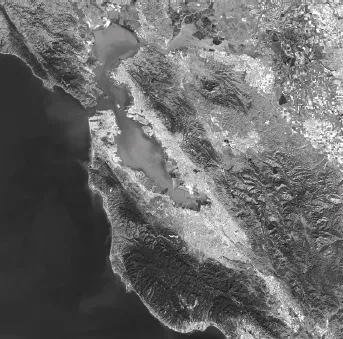
San Francisco Estuary and Inland Delta from satellite (source: Google Earth, October 2012).
Figure 1.1b
The San Francisco Estuary (photo by Sarah Moos).
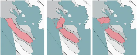
Most estuaries emerged 10,000 to 12,000 years ago, during the Holocene Period, when sea levels began to rise at the end of the last ice age. This is also partly true for the San Francisco Bay, an estuary of the Pacific Ocean and the inland delta formed by the Sacramento and San Joachim Rivers. But given the location of the Bay in a zone of great seismic activity, tidal and riverine dynamics were also shaped by tectonic forces. The two large tectonic plates, the North American and the Pacific Plates, slide past each other at a current speed of 2.5 cm per year (Stoffer & Gordon, 2001, pp. 61-86). The coastal ridges in Northern California started to uplift two to four million years ago when pressure along the North American Plate and the Pacific Plate increased along the plate boundaries. The valley between the two coastal ridges where the Bay resides began to form two to three million years ago. Geologists suspect that the lateral movement along the San Andreas Fault zone may be responsible for a major structural break in the western coastal ridge at the Golden Gate, causing a 130 degree clockwise rotation of the headlands.
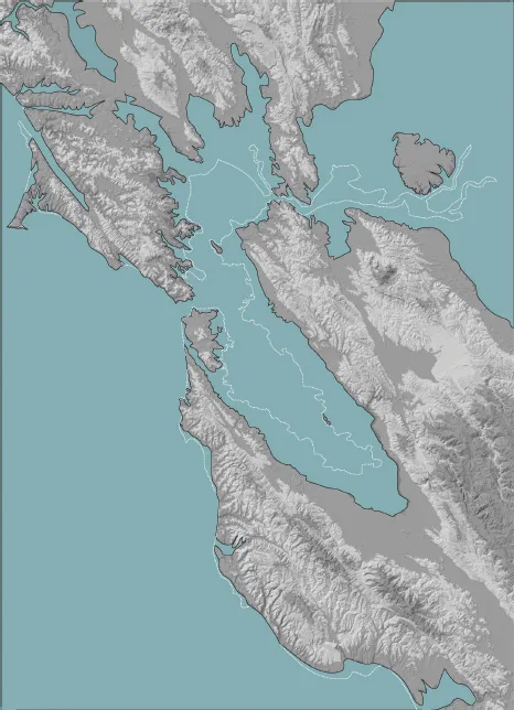
This structural break created an opening. During the construction of the Golden Gate Bridge in the 1930s, borings revealed seven distinct estuarine periods over the last 500,000 years, and they correspond to interglacial periods. During glacial periods the bay floor became a valley where rivers created deep incisions, most notably the Sacramento River, which has its origins in the once glaciated mountains of the Northern Sierra Nevada. The river carved a deep gorge inside what is now the Golden Gate Strait. Approximately 8,000 years ago, ocean water again returned, for the seventh time in the estuary’s 500,000-year history, to fill the Bay and to form the tidal estuary that we experience today (William, 2001). Figure 1.3 shows San Francisco Bay 125,000 years ago during the so-called Sangamonian (Hansel & McKay, 2014) interglacial period when the water table of the Bay was approximately 100 feet higher.
The Sacramento River with an annual discharge of 27 million cubic meters is joined by the San Joachim River to the east of San Francisco Bay, and the combined discharge amounts to 33 million cubic meters. Prior to the building of dams and water diversions for agriculture and urban use in 1914, the discharge would have been closer to 50 million cubic meters (Meko, et al., 2001). The two rivers and their tributaries drain the 1,000 kilometer long Sierra Nevada mountain range running north–south through all of Northern California. While the Sacramento–San Joachim River Delta is largely agricultural with few small towns, the two rivers are navigable by smaller ocean-going vessels to the major cities of Stockton and Sacramento.
Stream regulation through the delta started in the 1850s. Settling farmers hired Chinese laborers, largely from the Pearl River Delta, Guangdong Province, to reclaim marshland and cultivate rich layers of peat soil. That is soil built up from decomposed tule reeds through millennia. Levees 1,800 kilometers long by 3 meters high by 9 meters wide were constructed by manual labor using a combination of peat and clay soil, a colossal undertaking.
Figure 1.2
The opening of the coastal ridge at the Golden Gate as a result of tectonic movement along the San Andreas Fault (maps drawn by author, assisted by Justin Kearnan).
Figure 1.3
The Bay 125,000 years ago during the Sangamonian Interglacial Period, when the northern part of the San Francisco Peninsula was an island (map drawn by author, assisted by Justin Kearnan).
Delta soil is oxygen rich and causes subsidence when cultivated. Like the waterways of the Pearl River Delta and the Dutch Delta, silting riverbeds caused the water level of rivers and sloughs to rise higher than adjacent land. Flooding at times of heavy rains and snow melt produced levee failure. Land subsidence, levee failure, the diversion of freshwater for urban use, and saltwater intrusion made the delta a highly contested landscape. Growers compete with urban users for a limited amount of freshwater, and environmental advocacy groups compete with both to ensure the survival of the delta ecosystem. The latter group advocates for marsh restoration, or conversion of low-lying farmland to constructed wetlands.
After the confluence, the two rivers form a tidal estuary, Suisun Bay, and discharge at the Carquinez Strait into San Pablo Bay, the northern portion of San Francisco Bay. Here an additional number of small rivers discharge directly into San Francisco Bay. At the time of Spanish discovery, the Bay water surface measured 1.295 km2. In 1965, a surface area of 20,000 hectares had been reclaimed for urban use, railroads, highways, ports, an airport runway, military use and waste disposal.
The year 1965 is a critical date in the history of San Francisco Bay: a citizen-led campaign successfully stopped municipalities from additional land reclamation (Walker, 2007, p. 110). “For a century prior to 1965 no one thought twice about throwing anything and everything into the Bay. Canneries, rendering plants, tanneries discharged a river of effluvium; smelters, steel mills, and coal-gas plants spilled toxic ooze; and thousands of ships quietly voided their wastes into the water” wrote the political geographer Richard Walker (Walker, 2007, p. 112). A state chartered agency, the Bay Conservation and Development Commission, established in 1965, was created to prevent further bay fill and has reclaimed land for wetlands. Water quality of the Bay has improved significantly since 1965.
A current initiative will restore 15,100 acres of industrial salt ponds in the South Bay to wetlands. Understood as a soft edge approach, these wetlands will not only provide habitat for bay species, but they will also serve as a horizontal levee combating sea level rise. Functioning as a large sponge, wetlands can absorb water when needed and serve as flood-control measures often less costly than reservoirs or dikes. Studies suggest that areas with 30% more wetland coverage decrease flood peaks by 60% to 80% (Novitzki, 1978). Wetlands also sequester approximately 250 g/m2 carbon dioxide annually (Trulio, et al., 2007). Nearly all low-lying land along the Bay shoreline was once historic tidal marshland, making such land prone to subsidence. It is thus less valuable for development. Reverted to wetlands, these areas could become vegetated buffers between urban developments and the fluctuating tides (California Coastal Conservancy, 2015).
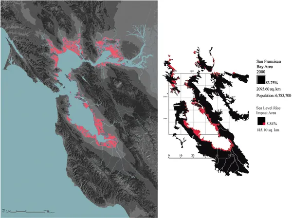
Figure 1.4
San Francisco Bay, inundation of low-lying land due to sea level rise. Left: under current projections, inundation by the end of the 21st century. Right: in red, inundation of urbanized land. Approximately 9% of all urbanized land would be inundated unless protected.
The San Francisco Bay water table has risen by 0.185 meters over the past century. By mid-century, a “one hundred year flood” is currently predicted to be 0.5 meters higher than today, and 1.4 meters higher by the end of the century (Heberger, et al., 2012). Unless protected by higher levees, sea level rise will inundate highway infrastructure, railroads, roadway and sewer treatment plants along the Bay, as well as industry in the southern and eastern portion of the Bay. Businesses in Silicon Valley, such as Oracle, CISCO, Facebook and Google, have all settled on or near former bay marshland and will all be at risk of inundation.
California Energy Commission predictions single out low-lying residential communities as the ones to be most affected. They emphasize that the 200,000 to 270,000 at-risk residents belong largely to minority and lower income communities. The commission concludes that sea level rise will have serious social justice implications.
Urbanization
Human settlements in the San Francisco Bay Area originated where Native Americans had settled in 126 small villages (Milliken, 2009).1 The native population in the Bay area amounted to approximately 17,000 at the time of Spanish arrival in 1769. Due to Spain’s policy of prohibiting foreign ships from entering ports on the west coast of the Americas, trade was limited, thus urbanization was virtually nonexistent in the rural areas around San Francisco Bay. Otto von Kotzebue (1787–1846) and fellow travelers on the Russian ship Rurik gave evidence. The ship under his command visited San Francisco Bay in October 1816. The historian A.C. Mahr (1932) suspected that the Rurik was on a spying mission. Russia, as a victorious nation in the Napoleonic wars, was keenly interested in the conditions along the Northern Californian coast, where it maintained colonies at Bodega Bay and Fort Ross in today’s Sonoma County. Spain, in a forced union with France from 1808 to 1814, had left its colonies in the Americas without support. A Russian aristocrat, Nicolay Rumyantsev, who had served as imperial chancellor until 1812, had financed the Rurik expedition, officially to find the fabled waterway, Avian, or North-West Passage, but, as Mahr suspected, also on a spying mission. The arrival of the Rurik in San Francisco Bay in 1816, one year after the Congress of Vienna, where Napoleon’s territorial conquests were redistributed, makes Mahr’s suspicion plausible. However, the Rurik had on board the well-known naturalist and poet, Adelbert von Chamisso2 (1781–1838) who served as Spanish interpreter. Chamisso’s diary, Tagebuch, 1821, does not confirm Mahr’s theory of a spying mission, but only attests to the scientific nature of the journey (Sterling, 2011). The Russian presence in the North Pacific had been an annoyance to Spain. So were the British interests in the fur trade that Russian hunters engaged in. The early Californian historian Robert Glass Cleland cites Adele Odgen: “men’s desire for the fur of an animal led to the commercial opening of the Pacific coast” (Cleland, 1962).
As history showed, urbanization around San Francisco Bay was not guided by Russian influence; Russia gave up its colonies in California in 1842. Nor was it guided by Spain; Mexico started its war of independence in 1810 and seceded from Spain in 1821. The Monroe doctrine of December 1823 put an end to European speculation to establish an independent kingdom west of the Rocky Mountains and up to the Pacific coast. The doctrine addressed mainly Russia, which had formed a holy alliance with Prussia and Austria to re-establish monarchical rule in the former Spanish colonies: “The American continents are henceforth not to be considered as subjects for future colonization by any European power” (Cleland, 1962, p. 59). Urbanization only gained momentum with the occupation of San Francisco Bay by the United States in 1846.
Given the remoteness of the Bay Area, only accessible by sea, water transport remained the most important connection between emerging cities throughout the remainder of the 19th and well into the 20th century. The Bay connected San Francisco with all other destinations: travelers going east to Sacramento, by 1852 the state capital, and onwards to the gold mines, traveled via the delta by boat up the Sacramento River; to San Jose for fruits and agricultural supplies via a small port at Alviso; to the north for ...
Table of contents
Cover
Half Title
Title Page
Copyright Page
Table of Contents
Foreword
Acknowledgements
Why this book?
Part I The San Francisco Estuary and Inland Delta
Part II The Pearl River Delta
Part III The Dutch Delta
Conclusion
Index
Frequently asked questions
Yes, you can cancel anytime from the Subscription tab in your account settings on the Perlego website. Your subscription will stay active until the end of your current billing period. Learn how to cancel your subscription
No, books cannot be downloaded as external files, such as PDFs, for use outside of Perlego. However, you can download books within the Perlego app for offline reading on mobile or tablet. Learn how to download books offline
Perlego offers two plans: Essential and Complete
Essential is ideal for learners and professionals who enjoy exploring a wide range of subjects. Access the Essential Library with 800,000+ trusted titles and best-sellers across business, personal growth, and the humanities. Includes unlimited reading time and Standard Read Aloud voice.
Complete: Perfect for advanced learners and researchers needing full, unrestricted access. Unlock 1.5M+ books across hundreds of subjects, including academic and specialized titles. The Complete Plan also includes advanced features like Premium Read Aloud and Research Assistant.
Both plans are available with monthly, semester, or annual billing cycles.
We are an online textbook subscription service, where you can get access to an entire online library for less than the price of a single book per month. With over 1.5 million books across 990+ topics, we’ve got you covered! Learn about our mission
Look out for the read-aloud symbol on your next book to see if you can listen to it. The read-aloud tool reads text aloud for you, highlighting the text as it is being read. You can pause it, speed it up and slow it down. Learn more about Read Aloud
Yes! You can use the Perlego app on both iOS and Android devices to read anytime, anywhere — even offline. Perfect for commutes or when you’re on the go. Please note we cannot support devices running on iOS 13 and Android 7 or earlier. Learn more about using the app
Yes, you can access Adaptations of the Metropolitan Landscape in Delta Regions by Peter C Bosselmann in PDF and/or ePUB format, as well as other popular books in Architecture & Sustainability in Architecture. We have over 1.5 million books available in our catalogue for you to explore.