![]()
Chapter 1
A SURREALISTIC GEOGRAPHY
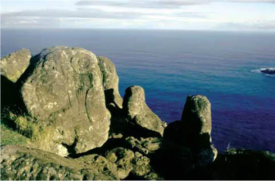
Figure 1.1. Petroglyphs, silhouetted against the Pacific Ocean and carved into the natural stone outcroppings, at the ceremonial village of Orongo.
CIVILIZATIONS throughout history have been strongly influenced by their environments. Some existed in relatively amenable areas of the world where they could easily mold and shape their natural surroundings to meet their needs. Others found themselves in areas of harsh and intractable geography where survival and mere accommodation took precedence in their culture’s development.
In studying the architecture of Easter Island, it is essential to understand the severe and almost surrealistic geographical conditions that prevailed a few centuries after the arrival of the first Polynesians. Once understood, it becomes easy to see how appropriate Easter Island’s architecture was to this stone island. Not only did Easter Islanders fit and adapt to their island’s dominating geology, but they shaped most of their built environment out of their one abundant material, volcanic stone. In addition to the stone architecture, they developed diverse residential architecture in wood and grass and used hundred of caves, formed by the natural crust of the earth, for shelter and protection.
Easter Island, a small volcanic island shaped like a triangle, is located just below the Tropic of Capricorn, 2,360 miles west of the port of Caldera in South America and, its mother country since 1888, Chile. It is the eastern-most Polynesian island.
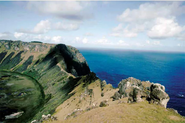
This triangle was created by the eruption of three large volcanoes, now inactive, that dominate the island. The highest and youngest is Mount Tere Vaka at 1,700 feet, containing a small crater lake named Rano Aroi. The second and oldest, standing at 1,200 feet high with basalt layers dating back three million years, is Poike in the eastern corner of the island. The southwest corner of the island is marked by the imposing cliffs and crater of Rano Kau, lush with green vegetation, containing a mile-wide freshwater lake 390 feet above the sea, which was, in ancient days, the most important reservoir on the island. The southern side by this volcanic crater has been eroded by thousands of years of pounding by the sea, creating a sheer cliff one thousand feet high. Someday it will crumble with a thunderous roar, opening the crater like the bursting of a dam into the sea. This is the site of the sacred village of Orongo, a most exquisite example of stone architecture and village planning.
Figure 1.2. Kari Kari, the lowest rim of Rano Kau’s crater, with the crater lake on the left and the Pacific Ocean on the right.
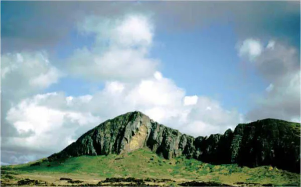
Figure 1.3. Rano Kau volcano defines the southwestern corner of the island.
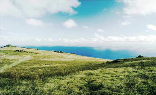
Figure 1.4. Today Easter Island’s treeless landscape is composed of rolling hills covered by a wavy carpet of grass.
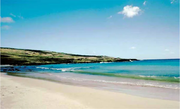
Figure 1.5. The shallow turquoise waters at Anakena Beach on the north coast. This beautiful horseshoe-shaped bay is thought to be where the first settlers arrived.
Figure 1.6. Rano Raraku volcano in the island’s southeast.
The island’s surface consists of volcanic ash and rock. The land surface is covered with blocks of lava, rocky outcroppings, and sharp-edged stones of all sizes scattered like a crusty blanket on the ground. The soil is in places razor thin and in places thick and fertile. The island’s almost treeless landscape is dominated by round hills with gently sloping sides, covered entirely by a waving carpet of grass. Most of these hills are part of the series of about seventy secondary craters and parasitic cones of the main volcanoes that reveal the complex events that shaped the island, two of which played a significant role in the development of the sculptural art of the ancient society. Rano Raraku volcano was the quarry for the giant stone sculptures, and Puna Pau volcano was the quarry where the large, red headdresses for the (moai) statues were cut and fashioned.
The climate is mild, consistent, and subtropical, a weather that originally spawned the typical tropical vegetation that conjures up visions of a Polynesian heaven on earth.
In the path of the trade winds and battered by strong local winds there are no deep and protected harbors or crescent coastal lagoons that would have allowed greater use of the sea. The exposed seacoast has been shaped by erosion, severely undercut by the roaring surf. The rugged basaltic stone, sculpted over millennia into a moonscape, is both fearsome and strangely beautiful. The black, jagged forms appear even stronger and more grotesque when silhouetted against the pure white foam of the sea as it crashes in from its boundless expanse. The entire scene, set to the music of the rolling waves, creates a total work of kinetic art. The snarled volcanic rock towering above the pounding surf is the perfect backdrop for the island’s organic architecture and towering sculpture.
Let’s compare Easter Island with the typical tropical high-volcanic islands to the west. This forbidding land lacks the most typical Polynesian amenities—the coral reefs and the long, wide stretches of black volcanic or white sand beaches—which gave their inhabitants enjoyment and a place from which to enter and exit the sea. There are but a few tiny beaches on Easter Island. The best is at Anakena Beach—only two hundred feet wide—and the place where oral tradition says the colonizing party led by the mythical founder of the culture, the ariki (chief) Hotu Matu’a, first landed a thousand years ago. Covered with rich vegetation and crossed by a perennial stream for centuries, it became the sacred abode of the paramount chiefs of the island.
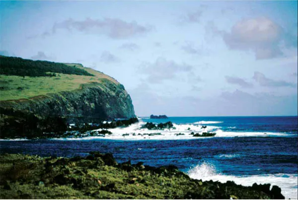
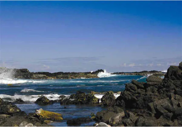
Figure 1.7. The Pacific Ocean beats against the rocky northern coast. The southwestern corner of the island can be seen in the background.
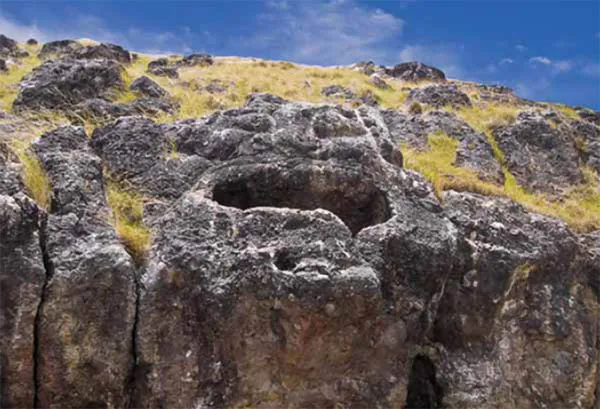
Figure 1.8. The large face of Vai a Heva at Poike volcano with its open mouth carved as a water reservoir.
There are no romantic, nurturing rivers to further man’s trade, communication, and quality of life—only a porous volcanic ground that sucked up the rain and, with the exception of the distant crater lakes, left little for man. Once underground, the fresh water flows down to the coast and into the ocean at low tide. Ancient Easter Islanders built trenches and wells to catch the water before it mixed with the sea’s saltwater. These water sites became focal points for the ancient settlements and were closely associated with their large ceremonial sites.
Shallow stone reservoirs were used to catch rainwater or spring water inland. Some of these reservoirs were hewn directly in large flat lava beds, while others were sculpted with large carved faces on stone outcrops, like the famous site of Vai A Heva at the Poike volcano (see figure 1.8).
For thousands of years before humans arrived, the island was covered not by desert wasteland but by a subtropical forest, dominated by a large population of cocoid palms. Upon the arrival of man toward the end of the first millennium of the Christian era, in about AD 800–900, the rich volcanic grounds were covered by varied and dense vegetation. Springs, possibly large permanent watercourses, and important endemic fauna, represented mainly by land birds and the most extraordinary variety and number of sea birds in Polynesia, were notable components of Easter Island’s landscape.
The AD 800–900 colonization dates proposal came from excavations at Anakena by Arne Skjølsvold et al.1 in the late 1980s and mainly from our (Vargas Casanova and Cristino) dig there in 1991 with David W. Steadman.2 However, when colonization took place has been the subject of intense debate since Terry Hunt and Carl Lipo, based on their excavations at the sand dunes of Anakena, argued for a later arrival around AD 1250.3
In a 2008 article, Marshall I. Weisler (University of Queensland) and Roger C. Green (University of Auckland) clarify the dates for the colonization of Easter Island:
While we could argue about the merits of their review and rejection of some of the oldest radiocarbon dates for Rapa Nui, what is less controversial is the current dating for Mangareva and the Pitcairn Group and the related claim of its compatibility with a date of 1200 CE for Rapa Nui. These islands are, on all evidence to date, the source of the founding population for Rapa Nui based on geographic position, radiocarbon dates, linguistics, material culture, introduced flora and fauna, physical anthropology, and voyaging feasibility.
Based on our brief review of colonization dates for Mangareva and the Pitcairn Group below, we disagree with Hunt and Lipo that “a date of about AD 1200 for the colonization of Rapa Nui fits well with the evidence that has emerged for colonization from elsewhere in the southeastern Pacific.” (2006:1605, emphasis the authors). Our review also underscores the need to examine colonization dates at the regional level, (Weisler, 1998) especially when it relates to the probable source of colonists that founded Rapa Nui.
Even one of the strong supporters for a generally late colonization scenario throughout East Polynesia cites the earliest known settlement of Anakena as dating to 1000 CE (Anderson 2006:275). This assessment is fully compatible with that of Vargas Casanova et al. (2006:403), who find there is no data from Rapa Nui at present to sustain an initial settlement more ancient than 800 CE nor for one judged to be later than 1000 CE. They base their evaluation on a detailed examination of their 1991 excavations at Anakena and the fine detail of its stratigraphic record, radiocarbon age determinations, fauna, cultural artifacts, their reinvestigations of the Poike “Ditch” feature, and their more general overview of all other well-dated sites investigated by others on that island.4
Patrick V. Kirch (University of California, Berkeley), who has conducted extensive archaeological and ethnoecological research throughout the Pacific Islands over the past three decades, thoroughly reviews multidisciplinary advances in knowledge and presents a chronology of the Pacific Islands’ settlement, including possible connections to South America in a recent article:
The human colonization of the Pacific is an enduring problem in historical anthropology. Recent advances in archaeology, historical linguistics, and bio anthropology have coalesced to form a set of models for population movements and interactions in Oceania, which have been tested on independent data sets. Earliest human movements into Near Oceania began about 40,000 years ago, resulting in great cultural, linguistic, and genetic diversity in this region. About 4,000 years ago, the expansion of Austronesian speakers out of Southeast Asia led to the emergence of the Lapita cultural complex in Near Oceania. The Lapita expansion into Remote Oceania, commencing about 1200 BC, led ultimately to the settlement of the vast eastern Pacific, ending with the colonization of New Zealand about AD 1250. Polynesians probably reached the coast of South America, returning with the sweet potato and possibly the bottle gourd. Polynesian influences on New World cultures remain a topic of debate.
The emerging picture is one of a fairly rapid Polynesian colonization of the chain of islands stretching from the Australs to Mangareva, Pitcairn-Henderson, and finally to Easter Island that occurred between roughly AD 800 and 1000.5
The original settlers ...