Wetlands and Habitats
eBook - ePub

Wetlands and Habitats

  1. 272 pages
  2. English
  3. ePUB (mobile friendly)
  4. Available on iOS & Android
eBook - ePub

Wetlands and Habitats

Book details
Book preview
Table of contents
Citations

About This Book

Authored by world-class scientists and scholars, The Handbook of Natural Resources, Second Edition, is an excellent reference for understanding the consequences of changing natural resources to the degradation of ecological integrity and the sustainability of life. Based on the content of the bestselling and CHOICE-awarded Encyclopedia of Natural Resources, this new edition demonstrates the major challenges that the society is facing for the sustainability of all well-being on the planet Earth. The experience, evidence, methods, and models used in studying natural resources are presented in six stand-alone volumes, arranged along the main systems of land, water, and air. It reviews state-of-the-art knowledge, highlights advances made in different areas, and provides guidance for the appropriate use of remote sensing and geospatial data with field-based measurements in the study of natural resources.

Volume 3, Wetlands and Habitats, provides fundamental information on wetlands and their integral functions as a productive ecosystem. The topics it covers include wetlands biodiversity, wetlands classification and monitoring, floods, river ecosystems, pollution, and more. New to this edition are discussions on wetland vegetation, assessment of current wetland health status, restoration, sea-level rises and coastal storm, vulnerability to human impacts, and lakes and wetlands remote sensing. This volume demonstrates the key processes, methods, and models used through many case studies from around the world.

Written in an easy-to-reference manner, The Handbook of Natural Resources, Second Edition, as individual volumes or as a complete set, is an essential reading for anyone looking for a deeper understanding of the science and management of natural resources. Public and private libraries, educational and research institutions, scientists, scholars, and resource managers will benefit enormously from this set. Individual volumes and chapters can also be used in a wide variety of both graduate and undergraduate courses in environmental science and natural science at different levels and disciplines, such as biology, geography, earth system science, and ecology.

Frequently asked questions

Simply head over to the account section in settings and click on “Cancel Subscription” - it’s as simple as that. After you cancel, your membership will stay active for the remainder of the time you’ve paid for. Learn more here.
At the moment all of our mobile-responsive ePub books are available to download via the app. Most of our PDFs are also available to download and we're working on making the final remaining ones downloadable now. Learn more here.
Both plans give you full access to the library and all of Perlego’s features. The only differences are the price and subscription period: With the annual plan you’ll save around 30% compared to 12 months on the monthly plan.
We are an online textbook subscription service, where you can get access to an entire online library for less than the price of a single book per month. With over 1 million books across 1000+ topics, we’ve got you covered! Learn more here.
Look out for the read-aloud symbol on your next book to see if you can listen to it. The read-aloud tool reads text aloud for you, highlighting the text as it is being read. You can pause it, speed it up and slow it down. Learn more here.
Yes, you can access Wetlands and Habitats by Yeqiao Wang in PDF and/or ePUB format, as well as other popular books in Biowissenschaften & Umweltschutz. We have over one million books available in our catalogue for you to explore.

Information

Publisher
CRC Press
Year
2020
ISBN
9780429818295
Edition
2
Subtopic
Umweltschutz

I

Riparian Zone and Management

1

Floodplain Management

French Wetmore
French & Associates, Ltd.
Historical Approaches
Floodplain Management
The National Flood Insurance Program
Other Federal Programs
Other Programs
Progress
Agricultural Concerns
Reference
Bibliography

Historical Approaches

During the 1920s, the insurance industry concluded that flood insurance could not be a profitable venture because the only people who would want flood coverage would be those who lived in floodplains. As they were sure to be flooded, the rates would be too high to attract customers. Unlike other hazards, such as wind and hail, where the risk can be spread, private industry opted out of playing a role in flood protection.
With the great Mississippi River flood of 1927, the federal government became a major player in flooding. As defined by several Flood Control Acts, the role of government agencies was to build massive flood control structures to control the great rivers, protect coastal areas, and prevent flash flooding.
Until the 1960s, such structural flood control projects were seen as the primary way to reduce flood losses. In some areas, they still are. However, starting in the 1960s, people questioned the effectiveness of this single solution. Disaster relief expenses were going up, making all taxpayers pay more to provide relief to those with property in floodplains. Studies during the 1960s concluded that flood losses were increasing, in spite of the number of flood control structures that had been built.
One of the main reasons structural flood control projects failed to reduce flood losses was that people continued to build in floodplains. In response, federal, state, and local agencies began to develop policies and programs with a “non-structural” emphasis, ones that did not prescribe projects to control or redirect the path of floods.
A milestone in this effort was the creation of the National Flood Insurance Program (NFIP) in 1968. The NFIP is based on a mutual agreement between the Federal government [represented by the Federal Emergency Management Agency (FEMA)] and local governments. Federally guaranteed flood insurance is made available in those communities that agree to regulate development in their mapped floodplains.
If the communities do their part in making sure future floodplain development meets certain criteria, FEMA will provide flood insurance for properties in the community. The Federal government is willing to support insurance because, over time, local practices will reduce the exposure to flood damage.
Also during the 1960s and 1970s, interest increased in protecting and restoring the environment, including the natural resources and functions of floodplains. Coordinating flood loss reduction programs with environmental protection and watershed management programs has since become a major goal of federal, state, and local programs. This evolution is shown graphically in Figure 1.1. Now, we no longer depend solely on structural projects to control floodwater. Instead of “flood control,” we now speak of “floodplain management.”
Image
FIGURE 1.1 Evolution of floodplain management in the United States.

Floodplain Management

Floodplain management is officially defined by the Federal Government’s Unified National Program for Floodplain Management as “a decision-making process that aims to achieve the wise use of the nation’s floodplains.” (see FEMA,[1] p. 8) “Wise use” means both reduced flood losses and protection of the natural resources and functions of floodplains. This is accomplished through different tools, including, but not limited to:
  • Floodplain mapping.
  • Land use regulations.
  • Preservation of floodprone open space.
  • Flood control (levees, reservoirs, channel modifications, etc.)
  • Acquiring and clearing damaged or damage-prone areas.
  • Floodproofing buildings to reduce their susceptibility to damage by floodwaters.
  • Flood insurance.
  • Water quality best management practices.
  • Flood warning and response.
  • Wetland protection programs.
  • Public information.
There are a variety of Federal, state, and local programs that administer these tools. Private organizations and property owners also have roles.

The National Flood Insurance Program

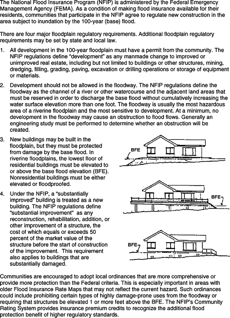
The nation’s focal floodplain management program is the NFIP. It has prepared floodplain maps for 22,000 communities. FEMA sets the minimum land use development standards that participating communities must administer within the floodplains designated on their Flood Insurance Rate Maps. These standards are summarized in Figure 1.2.
Image
FIGURE 1.2 Minimum National Flood Insurance Program regulatory requirements.
While participation is voluntary, communities that decide not to join or not to enforce those regulations do not receive Federal financial assistance for insurable buildings in their floodplains. Rather than face the loss of Federal aid (including VA home loans, HUD housing help, and disaster assistance), just about every community with a significant flood problem has joined. By 2002, 19,700 cities and counties were participating.
Within participating communities, Federal law requires the purchase of a flood insurance policy as a condition of receiving Federal aid, including mortgages and home improvement loans from Federally regulated or insured lenders. This requirement, coupled with personal experiences with flooding, has convinced over four million property owners to buy flood insurance. Unfortunately, it is estimated that only half of the properties in the FEMA mapped floodplains are insured.

Other Federal Programs

FEMA administers other floodplain management programs, including:
  • Disaster assistance programs that help flooded communities and property owners recover after a flood.
  • Mitigation assistance programs that fund local projects to acquire and clear floodprone properties.
  • Research and technical assistance activities in the fields of mapping, planning, mitigation, and floodproofing.
  • The National Dam Safety Program which assists state programs that regulate dams (dam failures were a factor in three of the four largest killer floods since 1970).
The U.S. Army Corps of Engineers is the second largest participant in Federal floodplain management programs. While it is best known as the builder of structural flood control projects, it has its own authority to regulate new development in navigable waterways and wetlands. It is also the leader in the technical aspects of floodproofing and river basin planning.
The U.S. Department of Agriculture’s Natural Resources Conservation Servic...

Table of contents

  1. Cover
  2. Half Title
  3. Series Page
  4. Title Page
  5. Copyright Page
  6. Table of Contents
  7. Preface
  8. About The Handbook of Natural Resources
  9. Acknowledgments
  10. Aims and Scope
  11. Editor
  12. Contributors
  13. Section I Riparian Zone and Management
  14. Section II Wetland Ecosystem
  15. Section III Wetland Assessment and Monitoring
  16. Index