![]()
Chapter 1
Introduction
Innovative approach used in this book. This book is written for students and those who would like to learn the fundamentals and practical applications of soil mechanics without having to go through numerous pages of “boring” theory and equations. It is intended to show the reader how we use soil mechanics in practice and why it is important to know soil behavior. Unlike existing books on soil mechanics, this one uses a different, project-based approach where the reader is introduced to a real geotechnical project, which was conducted to select the most appropriate place for canal construction. This project will underscore the need for the theory presented in this book. The reader will learn how to interpret and analyze the data from field and laboratory investigation as well as how to use it to solve various geotechnical problems. Every step of this project is related to a certain aspect of soil mechanics and as the reader acquires more knowledge in the process, they will be able to see the practical importance of what they have learnt and thus better understand it. Our teaching experience (Gratchev and Jeng, 2018) indicates that the understanding of basic soil properties and soil behavior is much more important than remembering how to derive theoretical equations or memorizing numbers. For this reason, we pay more attention to explaining important concepts and discussing step-by-step solutions to common geotechnical problems.
Book organization. The book is organized in such a way that each chapter first explains its relevance to the project and then briefly introduces key theoretical concepts necessary to complete a certain part of the project. Chapter 1 provides the project description and data from field investigation and laboratory testing. The following chapters deal with soil origin and exploration (Chapter 2), basic soil properties (Chapters 3–4), fundamental concepts of soil compaction (Chapter 5) and stresses in soil mass (Chapter 6) as well as more advanced geotechnical applications such as flow nets (Chapter 7), soil deformation and consolidation (Chapters 8–10) and shear strength and slope stability analysis (Chapter 11).
Material for self-practice. Each chapter provides practical problems that the reader should use for more practice. We suggest trying to solve each problem first before referring to the step-by-step solution provided afterwards. Even though it may be difficult to work it out all the way to the final answer, spending time on each problem will improve the reader’s understanding of the relevant material and help to develop problem-solving skills. In addition, to reinforce the knowledge of soil behavior and review the key concepts, the reader can take a quiz at the end of each chapter. To make this book more interactive, we have included several questions (and answers) that we commonly receive from our students.
1.1 Project description
In 2009, a residential canal was proposed at the Pimpama Riverside Development and geotechnical investigation was performed to assess the geotechnical settings of the area. The results of this investigation include a map (Fig. 1.1), a series of boreholes logs (Figs. 1.2–1.4) and laboratory reports (Tables 1.1–1.3). The main objective of this investigation was to determine properties of soil and estimate potential natural hazard and geotechnical issues that might occur during construction. Previous engineering developments in that area revealed some issues related to widely spread very soft clay, which was not appropriate foundation for most of engineering structures. To address this problem, it was considered to consolidate this soft material using a pre-load method (this will be discussed in detail in Chapter 10).
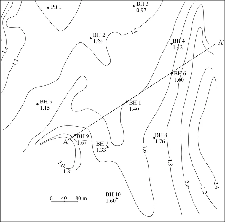
Figure 1.1 Map of the project area.
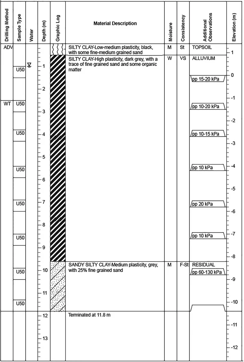
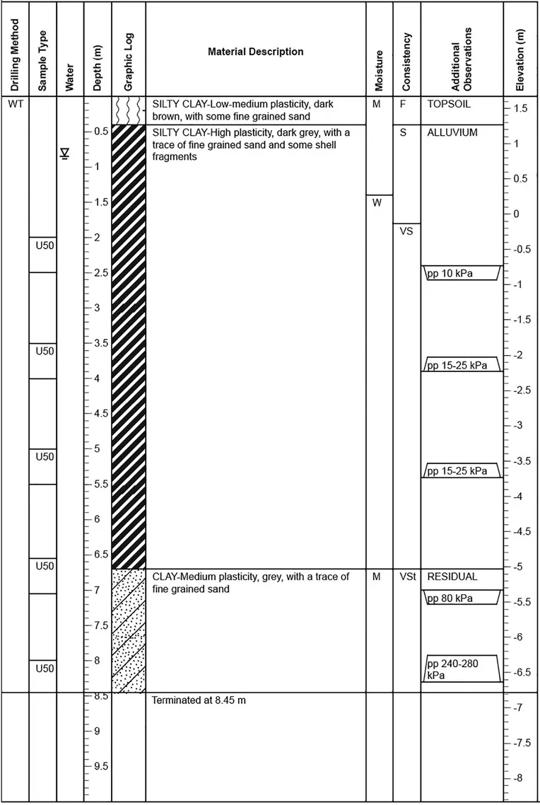
Figure 1.2 Borehole BH1, Elevation – 1.4 m. Borehole log legend: Drilling method: AD – auger drilling, V-“V” bit, W-washbore, T-TC bit. Sample type: U50-undisturbed sample 50 mm diameter. Moisture: M-moist, W-wet. Consistency: VS-very soft, F-firm, St-stiff. Additional observations: pp-pocket penetrometer.
Figure 1.3 Borehole BH6, Elevation – 1.6 m. Borehole log legend: Drilling method: W-washbore, T-TC bit. Sample type: U50-undisturbed sample 50 mm diameter. Moisture: M-moist, W-wet. Consistency: VS-very soft, F-firm, St-stiff. Additional observations: pp-pocket penetrometer.
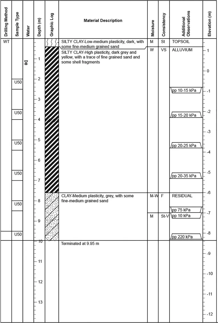
Figure 1.4 Borehole BH9, Elevation – 1.67 m. Borehole log legend: Drilling method: W-washbore, T-TC bit. Sample type: U50-undisturbed sample 50 mm diameter. Moisture: M-moist, W-wet. Consistency: VS-very soft, S-soft, F-firm, St-stiff, VST-very stiff. Additional observations: pp-pocket penetrometer.
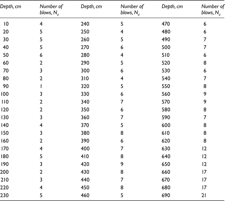
Table 1.1 Data from a dynamic cone penetration test. Location: near BH9.
1.2 Field data
Field data for this project includes a site map (Fig. 1.1) that shows surface elevation contours and borehole location and borehole logs (Figs. 1.2–1.4). The borehole logs contain information about soil type, moisture and consistency, which is useful for overall assessment of site conditions. Table 1.1 presents data from a dynamic cone penetration test which was conducted near BH9.
1.3 Laboratory data
Laboratory data includes results of particle size distribution and Atterberg limits tests as well as information about soil in-situ density and moisture content. Three different soil types were tested: alluvial silty clay (Table 1.2), residual soil (Table 1.3) and sand from Pit 1 (Table 1.4).
Table 1.2 Particle size distribution and consistency limits test report (alluvium).
Table 1.3 Particle size distribution and consistency limits test report (residual soil).
Table 1.4 Particle size distribution and consistency limits test report (sand from Pit 1).
Question: The project description contains lots of information, what shall we start with?
Answer: Geotechnical projects are typically divided into the following steps: a) collection, interpretation and analysis of field data; b) laboratory testing of soil samples obtained from the site and establishment of soil properties; c) identification of potential issues that can occur during or after construction and d) recommendation of most appropriate methods to deal with potential geotechnical issues.
As soil mechanics deals with underground soil conditions, it is necessary to have a good understanding of what soil or rock types are located at different depths. To do this, we will analyze the data from field investigation (borehole logs and DCP tests) and draw a soil cross-section (also known as soil profile) of the site. By interpreting field data, we will identify the main geological units and detect the ground water level. Chapter 2 will deal with basic geology and soil formation and discuss important aspects of field investigation.
Question: Soil mechanics seems to be a hands-on discipline; can we learn how to conduct field investigation from this book?
Answer: Unfortunately, no book can give you practical skills necessary to conduct field or laboratory investigations; it is something that you learn and develop by doing yourself. This book will show you why you need to study soil mechanics and help you learn and practice how to interpret and analyze data from field investigations and laboratory tests so that you can easily identify and deal with potential natural hazard or geotechnical issues. To find out more about field and laboratory tests, we recommend viewing videos of relevant tests, which are readily available on the Internet.