eBook - ePub
Geospatial Information System Use in Public Organizations
How and Why GIS Should be Used in the Public Sector
This is a test
- 266 pages
- English
- ePUB (mobile friendly)
- Available on iOS & Android
eBook - ePub
Geospatial Information System Use in Public Organizations
How and Why GIS Should be Used in the Public Sector
Book details
Book preview
Table of contents
Citations
About This Book
This book shows how Geospatial Information Systems (GIS) can be used for operations management in public institutions. It covers theory and practical applications, ranging from tracking public health trends to mapping transportation routes to charting the safest handling of hazardous materials. Along with an expert line-up of contributors and case studies, the editor provides a complete overview of how to use GIS as part of a successful, collaborative data analysis, and how to translate the information into cost-saving decisions, or even life-saving ones.
Frequently asked questions
At the moment all of our mobile-responsive ePub books are available to download via the app. Most of our PDFs are also available to download and we're working on making the final remaining ones downloadable now. Learn more here.
Both plans give you full access to the library and all of Perlego’s features. The only differences are the price and subscription period: With the annual plan you’ll save around 30% compared to 12 months on the monthly plan.
We are an online textbook subscription service, where you can get access to an entire online library for less than the price of a single book per month. With over 1 million books across 1000+ topics, we’ve got you covered! Learn more here.
Look out for the read-aloud symbol on your next book to see if you can listen to it. The read-aloud tool reads text aloud for you, highlighting the text as it is being read. You can pause it, speed it up and slow it down. Learn more here.
Yes, you can access Geospatial Information System Use in Public Organizations by Nicolas A. Valcik, Nicolas Valcik,Denis Dean, Nicolas Valcik, Denis Dean in PDF and/or ePUB format, as well as other popular books in Medicina & Sanità, amministrazione e assistenza pubblica. We have over one million books available in our catalogue for you to explore.
Information
Section IV
Practitioner Use of GIS in Public and Nonprofit Organizations
9 Uses of Geospatial Information Systems (GIS) for Public Higher Education Institutions
Introduction
College and university administrators face difficult and complex issues unique to higher education institutions. Problems at public institutions can be further compounded by local, state, and federal rules and regulations, which overlay more restrictions on what institutions can and cannot do to resolve certain problems. For example, complex issues can arise from right-of-way and storm water management to hazardous material (HAZMAT) locations to jurisdictional purview for university law enforcement officials. To resolve difficult and complex problems, administration needs to be innovative and must be willing to use new technology, which can provide additional information for administrative decision-making processes.
The examples throughout this chapter will tie in academic innovations utilizing GIS to provide spatial data that can potentially be useful in resolving complex issues for upper-level administrators. This chapter will discuss how GIS can be leveraged to quickly analyze how students and employees of a large public university intersect with additional large regional employers, insufficient transportation networks, and topography that can potentially strain existing infrastructure. Unlike an academic or classroom setting, a practitioner can face potential consequences if an administrator makes an error in the decision-making process. To illustrate situations in which GIS can be used administratively at universities and colleges in the decision-making process, several different examples encountered at West Virginia University will be highlighted.
Prior Research
Dr. John Snow is credited with not only the start of the field of epidemiology but also the beginning of using maps for operational action. In 1854, Dr. Snow began mapping cholera outbreaks related to water pumps in London to determine the source of the outbreaks and thus identify the source of the illness (UCLA, 2014). What might appear to be a simple exercise was actually considered cutting-edge data usage, with epidemiology intersecting with geographic data. As Figures 9.1, 9.2, and 9.3 show, the data by itself is limited until it is layered with the geographic data (Kukaswadia, 2013).
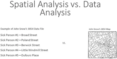
Figure 9.1 List of infected persons vs. infected persons pinpointed on a map.
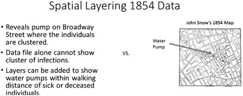
Figure 9.2 Water pump location.
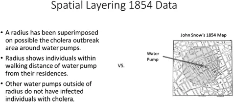
Figure 9.3 As can be seen in Figures 9.1, 9.2, and 9.3, the data allows decision-making to be made operationally since the data is triangulated with more than one data source.
GIS as a Tool for Administration
What is GIS, and why should higher education institutions use it as opposed to using Computer Aided Drafting (CAD) software? CAD is still an industry standard for architects and draftsmen for facility construction (United States Department of Agriculture Natural Resources Conservation Service, 2006). CAD is heavily used in public organizations, which in some cases have been using it since its inception in the 1970s. Using this resource has required organizations to train personnel, obtain hardware, and pay for software to keep up with current CAD capabilities and retain viability for universities and colleges. Frequently, CAD users are located in the facility management departments at colleges and universities in which facility information resides. However, for administrative purposes, CAD is very limited in both capability and interoperability for providing information to different administrative departments within a college or university. While CAD has been used extensively by architects and drafters, it has not been used by staff or faculty in administration or social science disciplines. This is because in addition to requiring specialized training, CAD is unable to utilize large informational databases on the same level as GIS, which can analyze and layer information.
In contrast to CAD’s existing capabilities, GIS has evolved over the years. GIS not only ties in large amounts of data to very specific locations but also can capture anything from floor plans to three-dimensional renderings to coordinate geometry. The expansion of GIS technology provides researchers, practitioners, and students a tool with which to investigate a wide array of research initiatives. CAD systems, however, have not evolved to intuitively accommodate those types of research or practitioner-based initiatives. Administrators need to use the right tool for the right job, and for many, administrative GIS is a superior tool for the decision-making process.
Additionally, GIS has the capability utilize a wide array of coordinate systems, elevation models, satellite imagery, aerial photography, and seamless integration with server databases (i.e. Microsoft SQL Server, Oracle etc.). GIS has effectively created a new generation of geographers and geoscientists with a reputation for being able to perform research with high-tech tools (Golledge, 2001). Gone are the days of geographers making maps with pen and paper (Titus, 2001). The perception of geographers and geoscientists using laptops and laser scanners is becoming more commonplace within the academic community. With the advent of GIS, universities and colleges now have newly created GIS academic programs that are enrolling students at the undergraduate, professional, and graduate level. With these types of degree offerings come the opportunity to integrate GIS with new administrative procedures and research in addition to the many education applications in higher education (Pilesjö and Mårtensson, 2009; Space Daily, 2012).
The effective use of GIS by administration in higher education can assist in resolving and researching a number of issues faced by almost every campus throughout its lifecycle. The Harvard Planning and Project Management at Harvard University for example, maintains the university’s GIS capability, which is used to create maps and analyses. The GIS group provides standard and custom maps, geographic data, and tools that enable staff to develop their own maps, geographic analyses, data development, and 3D modeling (Harvard University, 2015).
While GIS has been used for epidemiology and in the social sciences, GIS usage for administrative purposes in higher education has been very limited (2018). The administrative use of GIS is growing with institutions that have a robust GIS academic program (e.g. the University of Texas at Dallas, West Virginia University, Penn State University, Stanford University, and Central Washington University). With the support of academic units in the form of software licensing, expertise, and student workers, there have been more higher education institutions using GIS for a variety of purposes over the past few years. The University of Arizona has been using GIS for a number of years and has implemented an enterprise GIS component for planning throughout their campus (McCormick, 2003).
Ohio State University has been using GIS for admissions and recruiting efforts since the late 1990s (Mora, 2003). The university is also using GIS to map down enrolled students and combine that data with United States Census data to obtain additional information on enrolled students (Granados, 2003). Binghamton University has been using GIS to analyze patterns of alumni giving to the university, and the University of Wisconsin system has utilized GIS to analyze survey data and to plan how surveys are administered (Blough, 2003; Jardine, 2003). Western Kentucky University, which currently uses GIS for planning and construction for the university, is an example of GIS becoming more commonly used (Western Kentucky University, 2014). The University of Texas at Dallas used GIS in conjunction with the Logistical Tracking System (LTS) not only to construct floor plans but also to track inventory and HAZMAT throughout the university (Valcik, 2007, 2010). Prior research on proximity analysis is very limited in terms of university administration decision-making processes that use GIS.
Background on Using GIS at West Virginia University
GIS has a substantial presence at West Virginia University, with an active academic program that offers a bachelor’s degree, master’s degree, and PhD in GIS (West Virginia University—Geography Program, 2014). The agriculture, geography, geology, and medical departments at West Virginia University currently utilize GIS software for both research and academic purposes. Additionally, the State of West Virginia’s GIS Technical Center (WV GIS Tech Center) is located at West Virginia University. The WV GIS Tech Center was created in 1993 by Executive Order 4–93 and was established at West Virginia University in 1998. The department’s current objectives are as follows:
- Reduce the duplication of data development efforts among organizations
- Catalog and distribute GIS spatial data and information free-of-charge through the Internet
- Coordinate acquisition of new data additions to the West Virginia Spatial Data Infrastructure
- Assist with strategic planning, development and implementation of statewide mapping guidelines
- Provide advisory services and training programs in the field of geographic information science
- Conduct research and provide education towards improvement of geographic information technologies
(West Virginia GIS Technical Center, 2015)
Until recently, West Virginia University traditionally outsourced administrative GIS work for facility information and land inventory. The university has since invested time and resources in looking at the utilization of GIS for planning purposes at the institution. Over the past several years, West Virginia University’s Facilities Planning and Scheduling department has been utilizing GIS. The major utilization of GIS has been for the organization and management of the university’s deeded and leased properties. In addition to managing the university’s land holdings, GIS has been utilized as a tool for many different types of projects. West Virginia University also uses GIS for projects such as statistical spatial analysis of recruitment, storm water management, and space allocation analysis, and to create web-based map apps for internal departmental usage.
Unique West Virginia University Campus Characteristics
West Virginia University is the flagship higher education campus in the State of West Virginia. The university has an agriculture research and academic program along with health sciences, which has led to it to have a presence in every county in the State of West Virginia. These extensive land holdings either are property for agriculture purposes or provide health services mission. In addition to having property for education and outreach, West Virginia University owns many tracts of land and minerals, which serve a dual role as an outdoor laboratory and valuable natural resources, such as timber and coal. The campus itself has anywhere from three to six campus segments, depending on who defines what a “campus” comprises for each segment of the university. Currently, there is the original downtown campus, the Evansdale campus, and the health sciences campus. There are also three other segments of the campus: the law school (often lumped into the Evansdale campus), the athletic complex (basketball coliseum, soccer fields, etc., which are lumped into Evansdale), and the administrative areas, which are located off Waterfront Place, one mile from the downtown campus. To link the three campuses together, in the 1970s West Virginia University developed the Personal Rapid Transportation (PRT) thanks to a federal grant; this moves students, employees, and citizens throughout the three locations (West Virginia University—Personal Rapid Transportation, 2014). The PRT transports students throughout the three regions of the university’s main campus via a pseudo train system, without the use of personal vehicles or bus lines (West Virginia University GIS Technical Center, 2015). However, the student population has necessitated bus transportation to be added.
The PRT was specifically designed and constructed for students, faculty, and staff to travel between the three regional areas’ housing university facilities. It is currently being upgraded, as it was originally designed as a unique transportation system that only served the campus’s three main segments along the initial track. However, the campus has now expanded beyond its original boundaries, with the administrative areas located a mile away from the downtown campus. Du...
Table of contents
- Cover
- Half Title
- Title
- Copyright
- Dedication
- Contents
- Foreword
- Acknowledgments
- About the Editor
- About the Authors
- Section I Introduction
- Section II Academic and Theoretical Research GIS Topics
- Section III Applied Research Using GIS
- Section IV Practitioner Use of GIS in Public and Nonprofit Organizations
- Section V Conclusion
- Index