- 296 pages
- English
- ePUB (mobile friendly)
- Available on iOS & Android
eBook - ePub
Introducing Groundwater
About this book
Presented in a style intended for the non-specialist reader, with technical terms and mathematical formulae kept to a minimum, the second edition of this introduction to groundwater covers a range of topics as they relate to hydrogeology. A major new chapter focuses on pollution.
Tools to learn more effectively

Saving Books

Keyword Search

Annotating Text

Listen to it instead
Information
Introduction 1
Every year about 110 million million cubic metres (m3) of water falls as precipitation on the land areas of the Earth. With a world population estimated at 5700 million, that means that we each receive on average about 53 000 litres, or 53 tonnes, of fresh water per day, and that is without considering the water that falls as rain and snow over the oceans. Surely, there should be enough water to go around.
Yet in spite of this apparent abundance, thousands of people die every day from diseases associated with inadequate supplies of clean water. The problem of course is not the amount of water, nor the number of people, but the relative distribution of the two — and the fact that the water arrives unevenly over time.
To counter these problems, people have always tried to place their settlements near reliable sources of water, where there is some natural feature that somehow smoothes out the uneven distribution of the rainfall — a lake to store it, perhaps, or a river bringing water from a region with a heavier or more reliable rainfall. It would be difficult to name any major town in the United Kingdom, or a capital city anywhere in the world, that does not lie on the banks of a river. There are admittedly other reasons for this — defence and communication being obvious ones — but the availability of water must always have been a key factor.
There are of course some areas of the world where, for reasons of climate or of geology, there are no permanent streams or rivers; yet many of these areas have been settled for thousands of years. The inhabitants of the early settlements relied for their supplies on water which occurs underground, often within a few metres of the surface, and which they exploited by digging wells. Sometimes the names of the settlements — names that in Britain end in '-well' or in the Middle East begin with 'Bir' or 'Beer' — testify to the nature of their water supply.
In the early cultures of Britain and the Middle East the origin of underground water may not have been understood, but its existence was known and exploited. In Britain today many people not only do not realize that much of the nation's water supply is drawn from underground, they are also unaware that underground water is common and widespread. As most people in Britain take their water supplies, along with their energy supplies, for granted, it is unlikely that they would stop to wonder where the water was coming from until the day when it failed to arrive; 'you never miss the water till the well runs dry' is a saying with a literal meaning in addition to the figurative one. The lack of awareness is perhaps inevitable, because the underground supplies are invisible and so cannot have the same impact on the senses as the expanse of a lake or the roar of a waterfall. It is however unfortunate, because underground supplies represent the largest accessible store of fresh water on Earth. They also frequently provide the best — in some cases the only — solution to the problem of providing water for drinking and irrigation in the developing world.
How does this underground water occur? How widespread is it, and how reliable as a source of supply? How can it be protected and best utilized for the benefit of people? A science called hydrogeology — a branch of geology devoted to the study of underground water —has grown up in an attempt to provide detailed answers to these and related questions. This book is an attempt to provide some of the answers in general terms for those people who are curious about one of our most precious assets — people who want to think about the water before the well runs dry.
Water underground 2
In Xanadu did Kubla Khan
A stately pleasure-dome decree:
Where Alph, the sacred river, ran
Through caverns measureless to man
Down to a sunless sea.
A stately pleasure-dome decree:
Where Alph, the sacred river, ran
Through caverns measureless to man
Down to a sunless sea.
Samuel Taylor Coleridge
Many people share with Coleridge the idea that underground water occurs in vast lakes in caverns. They picture the water as flowing from one lake to another along underground rivers. Successful wells or boreholes, they imagine, are those that intersect these lakes or rivers; unsuccessful ones are those that encounter only 'solid' rock. The art of the water diviner or dowser is seen as predicting the location of these postulated subterranean watercourses, and so selecting a site for a borehole where water will be struck.
These popular misconceptions probably grew up because the only places where it is possible to see underground water in its natural state are the spectacular caverns that occur in hard limestones such as those of the Mendips and the Peak District in Britain, and in Kentucky and New Mexico in the USA. Visitors to these and similar caves are told that they were formed by the action of underground water. They hear of rivers that disappear into the ground in one place to reappear elsewhere, having flowed underground for parts of their courses. Not surprisingly, many of the visitors form the impression that this must be the normal mode of occurrence of all subsurface water. If this were so, since people are never slow to make money from others, we might expect to find many other places where tourists could venture into the ground to see such features. The fact that they are relatively rare suggests either that underground water is restricted in its occurrence, or that it normally occupies less spectacular habitats. The latter possibility is borne out by the fact that in the regions where caverns are common, wells and boreholes are rare. Those parts of Britain that draw heavily on underground water for their supplies — such as the chalk lands


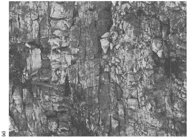
Figure 2.1 Different types and sizes of voids in rock. (a) Photograph taken with an electron microscope (an electron photomicrograph) of sandstone of Permian age from a borehole in Cumbria, England. The porosity is 31%. (b) Electron photomicrograph of chalk from a borehole in Berkshire, England, showing the minute fossils and shell fragments that make up the chalk. The porosity is 46% but the small size of the pores means that in the absence of fissures the permeability is low. (c) Pore space resulting from fissures in limestone of Jurassic age (Great Oolite) in a quarry in the Cotswold Hills, England. Such fissures contribute most of the permeability of this aquifer, (d) A fissure which has been greatly enlarged by solution in Jurassic (Inferior Oolite) limestone, Cotswold Hills, ((a) and (b) are reproduced by permission of the Director, British Geological Survey.)
of southern England and the sandstone tracts of the Midlands — contain few natural caves.
To understand the ways in which water occurs underground, we first need to think a little about the ground itself. Britain, like the rest of the Earth's crust, is made up of rocks of various types; in many parts of Britain these rocks are not readily seen, because they are hidden by soil and the landscape is clothed by vegetation. But rocks can be seen in seaside cliffs, on mountainsides and, among other places, in quarries and cuttings. Wherever we live, if we probe deeply enough below the surface of the Earth, we shall eventually encounter rock.
In Chapter 7 we shall look in more detail at different types of rock, but for the present we need to note only one feature. This is that nearly all rocks in the upper part of the Earth's crust, whatever their type, age or origin, contain openings called pores or voids. These voids (Figure 2.1) come in all shapes and sizes. Some of them — like the tiny pores in the chalk of the English downlands — are too small to be seen with the unaided eye. However, in exceptional cases, the openings may be tens of metres across, like the limestone caverns referred to earlier.
One common rock, sandstone, has pores that are more easily visualized (Figure 2.1a). If you take a handful of sand and look at it closely — preferably through a magnifying glass — you will see that there are numerous tiny openings between the grains of sand. If you cannot readily find a handful of sand, look at granulated sugar which shows exactly the same feature. Sandstone is merely sand that has turned into rock because the grains of sand have become cemented together, and most of the openings will usually have been retained in the process — it is as though our granulated sugar had become a block of sugar.
The property of a rock of possessing pores or voids is called porosity. Rocks containing a relatively large proportion of void space are described as 'porous' or said to possess 'high porosity'. Soil also is porous. On a hot summer day the surface soil may appear quite dry, but if we dig down a little way the soil feels damp; if we could dig far enough to reach rock, this too would feel damp. The reason for this is that the pores are not all empty; some of them are filled, or partly filled, with water. In general it is the smaller pores that are full and the larger ones that are empty. At a still greater depth we should find that all the pores are completely filled with water, and we should describe the rock or soil as 'saturated'. In scientific terms we should have passed from the unsaturated zone to the saturated zone.
If we dig or drill a hole from the ground surface down into the saturated zone, water will flow from the rock into our hole until the water reaches a constant level. This will usually be at about the level below which all the pores in the rock are filled with water — in other words, the upper limit of the saturated zone. We call this level the water table.
The distance we need to drill or dig to reach the water table varies from place to place; it may be less than a metre, or more than a hundred metres.
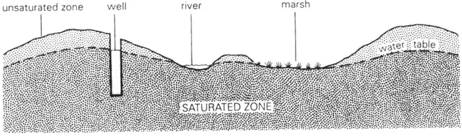
Figure 2.2 The water table.
In general the water table is not flat; it rises and falls with the ground surface but in a subdued way, so that it is deeper beneath hills and shallower beneath valleys (Figure 2.2). It may even coincide with the ground surface. If it does we can easily tell, because the ground will be wet and marshy or there will be a pond, spring or river. Where the water table is below the ground, as is usual, its depth can be measured in a well.
All water that occurs naturally below the Earth s surface is called subsurface water, whether it occurs in the saturated or unsaturated zones. (I insert the word 'naturally' so as to exclude from the definition water in pipes, and the like.) Water in the saturated zone, that is to say below the water table, is called ground water or groundwater. Early practice was to write the term as two words, but in Britain — and more recently in North America — there is an increasing tendency to write it as one word, to emphasize the fact that it is a technical term with a particular meaning.
Why is groundwater important? One reason, mentioned in the introduction, is that in some areas it is the only source of water. A second reason is that groundwater represents a major proportion of the Earth's usable water resources.
It is estimated that the total amount of water on the Earth is a little over 1400 million cubic kilometres (km3). Of this total about 1370 million km3, or about 95%, is sea water. Much of the remainder — about 2% of the total — occurs in solid form in glaciers and polar ice-caps. Virtually all of the remaining water — the non-marine, unfrozen water — is groundwater. The water in rivers and lakes, in the atmosphere and in the unsaturated zone, together amounts to only about l/50th of 1% of the world's total water supply.
For reasons that we shall see later, it is probably more difficult to make an accurate estimate of the volume of groundwater on the Earth than it is to estimate any other component of the total water resources of the planet. Estimates of the volume of groundwater range from around 7 million km3 to as much as 60 million km3. Not all of it is usable: some is held in pore spaces that are so small, or in rocks that are so deep, that it is not really a resource. Similarly, some occurs in permanently frozen ground in high latitudes, and more is saline. Nor is groundwater distributed uniformly over the land areas of the world. Where it is accessible, it can be used — and has been used — literally to make deserts bloom, to make the difference between wilderness and plenty.
In terms simply of quantity, groundwater is therefore of great importance. But quantity is not everything, and groundwater has several other advantages over surface water as a source of supply. A surface reservoir must usually be impounded at one time, in one place, even though its full capacity may not be needed for many years. Groundwater can often be developed where and when it is needed, by sinking boreholes one at a time in appropriate places; if demand for water increases less rapidly than expected, the water-supply authority is not left with an expensive liability in the form of a man-made lake that nobody needs.
Unlike surface-water reservoirs which occupy large areas, frequently of prime agricultural land, the presence and utilization of groundwater need not conflict with other use of the land under which it occurs. Deep beneath the ground it is unseen, insulated from changes in temperature, and protected from evaporation which, i...
Table of contents
- Cover
- Title
- Copyright
- Dedication
- Contents
- Foreword
- Preface
- Preface to the first edition
- Acknowledgements
- 1. Introduction
- 2. Water underground
- 3. Water in circulation
- 4. Caverns and capillaries
- 5. Soil water
- 6. Groundwater in motion
- 7. More about aquifers
- 8. Springs and rivers, deserts and droughts
- 9. Water wells
- 10. Measurements and models
- 11. Water quality
- 12. Groundwater: friend or foe?
- 13. What goes down must come up
- 14. Epilogue
- Index
Frequently asked questions
Yes, you can cancel anytime from the Subscription tab in your account settings on the Perlego website. Your subscription will stay active until the end of your current billing period. Learn how to cancel your subscription
No, books cannot be downloaded as external files, such as PDFs, for use outside of Perlego. However, you can download books within the Perlego app for offline reading on mobile or tablet. Learn how to download books offline
Perlego offers two plans: Essential and Complete
- Essential is ideal for learners and professionals who enjoy exploring a wide range of subjects. Access the Essential Library with 800,000+ trusted titles and best-sellers across business, personal growth, and the humanities. Includes unlimited reading time and Standard Read Aloud voice.
- Complete: Perfect for advanced learners and researchers needing full, unrestricted access. Unlock 1.4M+ books across hundreds of subjects, including academic and specialized titles. The Complete Plan also includes advanced features like Premium Read Aloud and Research Assistant.
We are an online textbook subscription service, where you can get access to an entire online library for less than the price of a single book per month. With over 1 million books across 990+ topics, we’ve got you covered! Learn about our mission
Look out for the read-aloud symbol on your next book to see if you can listen to it. The read-aloud tool reads text aloud for you, highlighting the text as it is being read. You can pause it, speed it up and slow it down. Learn more about Read Aloud
Yes! You can use the Perlego app on both iOS and Android devices to read anytime, anywhere — even offline. Perfect for commutes or when you’re on the go.
Please note we cannot support devices running on iOS 13 and Android 7 or earlier. Learn more about using the app
Please note we cannot support devices running on iOS 13 and Android 7 or earlier. Learn more about using the app
Yes, you can access Introducing Groundwater by Michael Price in PDF and/or ePUB format, as well as other popular books in Biological Sciences & Environmental Science. We have over one million books available in our catalogue for you to explore.