This book provides an essential insight into the practices and ideas of maps and map-making. It draws on a wide range of social theorists, and theorists of maps and cartography, to show how maps and map-making have shaped the spaces in which we live.
Going beyond the focus of traditional cartography, the book draws on examples of the use of maps from the sixteenth century to the present, including their role in projects of the national and colonial state, emergent capitalism and the planetary consciousness of the natural sciences. It also considers the use of maps for military purposes, maps that have coded modern conceptions of health, disease and social character, and maps of the transparent human body and the transparent earth.
Trusted by 375,005 students
Access to over 1.5 million titles for a fair monthly price.
My objective … has been to create a history of the different modes by which, in our culture, human beings are made subjects.
(Foucault, The Subject and Power)
1 Maps and worlds
It has always been this way with the map-makers: from their first scratches on the cave wall to show the migration patterns of the herds, they have traced lines and lived inside them.
(Sonenberg, Cartographies)
In a presentation nearly a decade ago, the Swedish geographer Gunnar Olsson began with the comments: ‘I have come a long way to tell you a story … it is a story of a finger and an eye.’1 He then asked: ‘What is geography if it is not the drawing and interpreting of a line?’. And what is the drawing of a line if it is not also the creation of new objects? Which lines we draw, how we draw them, the effects they have, and how they change are crucial questions (see also Olsson 1992a, 1992b, 1998).
In the years since Olsson’s presentation, I have struggled with the implications of his suggestion that the drawing of lines is a fundamentally geographical and spatial act in which identities are ‘inscribed’ and the logos of western thought is founded. Gunnar’s questions, caught as they are between a deep spatial analytic sensibility and a rethinking of modernist epistemologies and practices, result in a rich geopolitics of lines, boundaries and limits in which the geographical imagination is pushed to what he called ‘the dematerialized point of abstractness’. Here I want to focus on the implications of his work for how we understand the cartographic project and the geographical imagination that undergirds it, how – as the Sonenberg and Foucault quotations with which I began suggest – we have lived within the lines we have traced and been made the subjects we have become. Let me begin with Olsson’s finger and eye.
The finger is literally indexical – it points to something to draw our attention to it. It literally fingers the flux of the world to identify something: it delimits from a field a point, a place, an object for our attention. It stabilizes a particular meaning within a world of possible meanings. And in the modern world it generally does this by asking us to look at this thing, this object, this place. How, then, do we point to the world and which ‘lines of power’ are inscribed through our contemporary social and scientific practices? How do we map the world?
Olsson suggests a historical and analytical reading of three ‘lines of power’ at work in the drawing and reading of a line (‘=’, ‘/’, ‘
’). Each is indicative of a particular epistemology and mapping. The first are the lines of equivalence (‘=’), an epistemology of realism in which the concept refers to the thing (what Richard Rorty called philosophy as the mirror of nature). The second is the slash, the line of relation, the dialectic (‘/’), which – he asserts perhaps mischievously – we now know to be dead. The third line is the dash (‘
’) – the line that binds signifier and signified, and whose form is semiotics. Each represents for Olsson a fundamentally different epistemology, and the move from lines of equivalence to relation to signification also represents a transition in structure and practices of knowledge production: it reflects a fundamental reworking of the categories and institutions of disciplined practices.
In his 1987 introduction to Institution and Interpretation Sam Weber had similarly argued that an epistemic shift was underway. Drawing on the French philosopher Gaston Bachelard, Weber asked how traditional modes of thinking were being reconfigured within the sciences, what Bachelard had called ‘The New Scientific Spirit’. At stake in these reconfigurations ‘is nothing less than the idea or ideal of knowledge based on a notion of truth conceived in terms of the adequatio intellectus et rei’ (the adequation of thought and thing), the sign of equivalence. As Weber goes on to explain:
The effects of such problematization … extend far beyond the domain of ‘methodologies’. The widespread ‘identity crisis’ that is affecting a variety of different disciplines today is only the most obvious indication of a process of rethinking … what has changed is the relation of identity to nonidentity, of inclusion to exclusion. … In short, the traditional conception that holds space and time to be measurable in terms of ‘the point and the instant’ is irrevocably shaken by contemporary science.
(Weber 1987: x, xi)
This is precisely what Gunnar Olsson sought to capture in his ‘lines of power’. But to the lines, Olsson added the ‘eye’. The ways in which the world has been represented visually have, historically, been important elements of the ways in which we have come to understand and act upon the world. Crucial to this way of seeing the world has been the project of universal science and the emergence of what Marie Louise Pratt (1992) has called ‘planetary consciousness’. Mapping and cartography – the drawing of lines and the bounding of objects – have been at the heart of this consciousness. Mapping technologies and practices have been crucial to the emergence of modern ‘views of the world’, Enlightenment sensibilities and contemporary modernities. The world has literally been made, domesticated and ordered by drawing lines, distinctions, taxonomies and hierarchies: Europe and its others, West and non-West, or people with history and people without history. Through their gaze, gridding, and architectures the sciences have spatialized and produced the world we inhabit. And, indeed, this is perhaps the crucial issue: maps provide the very conditions of possibility for the worlds we inhabit and the subjects we become.
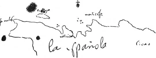
Olsson’s comments, therefore, point not only to an understanding of geography engaged with questions of identity and difference, with boundaries and transformations, and with categories and their dissolution. But he points also to an understanding of a world that has, in large part, been made as a geo-coded world; a world where boundary objects have been inscribed, literally written on the surface of the earth and coded by layer upon layer of lines drawn on paper. Cartographic institutions and practices have coded, decoded and recoded planetary, national and social spaces. They have literally and figuratively over-coded and overdetermined the worlds in which we live. They have respaced the geo-body. Maps and mappings precede the territory they ‘represent’. Just as scientific facts are produced through the overlay and repetition of circulating references (Latour 1999), so also ‘a geographical discovery is not really made until it has been recorded with sufficient accuracy so that it can be visited again’ (Thrower 1976: 659 quoting Skelton 1967: 4) (Figure 1.1): territories are produced by the overlaying of inscriptions we call mappings.
Each of Olsson’s ‘lines of power’ can be read as descriptions of forms of lived experience. The drawing and reading of a line, the historical emergence of cartographic reason, the production and circulation of a map, and lived experience are so thoroughly and historically intertwined and overdetermined. Take the example of my 7-year-old son poring over a new book on whales. On turning a page, he comes across a simple world map of the distribution of breeding and feeding grounds. In his first ‘reading’, his index finger slides across the page guiding his eye across the map. He locates feeding and breeding grounds and he understands somehow that he can read each relationally. Connected by red arrows indicating annual migration streams, the locations are now read dynamically as part of a seasonal flux in the lives of whales generally. It is clear to any observer, not just a father, that what is occurring in this discussion of fixed and relative location is a rich evocation of, and dwelling in, a world of symbolic and metaphorical forms. The map is literally ‘swimming’ with places, relations, fluxes, meanings and potentialities – with whales, waters and seasons – and perhaps particularly so for a 7-year-old. Already socialized into the world of abstract spaces (a surprise to his parents), he is able to ‘read’ the map with ease and joy; he dwells in the geographical worlds of whales for a few precious moments and through the map he structures his understanding of their worlds and he structures his own world a little more.
Figure 1.1 What is Geography if it is not the Drawing and Interpreting of a Line? Hispaniola, C. Columbus (Library of Congress, Washington, DC)
As Olsson indicated by adding ‘the eye’ to his story, modern science rests on what Derek Gregory (1994: 15) has called the ‘problematic of visualization’. From Descartes to Goethe, the experience of the healthy corporal eye was a direct and true reflection of reality (Crary 1995: 97–8). But, as Jonathon Crary (1995: 9) has suggested, such truth effects ‘were, in fact, based on a radical abstraction’, an epistemology of ‘plain vision’ (and the practices, instruments, and institutions that were associated with it) that naturalized sight as a source of clear unmediated knowledge (Krygier 1997: 30; see also Edney 1997). For geographers, the ways in which the map became ‘a theory which geographers … accepted’ (Ullman 1953: 57) is the story of the radical abstraction of the practices of the finger and the eye, the history of the technologies and institutions of map-making and map use, and ways of seeing and thinking; a story we need to revisit (Figure 1.2).
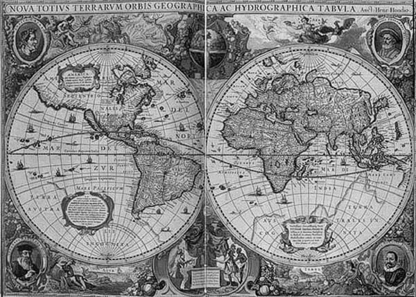
In a broader sense, this is what the philosopher Martin Heidegger (1982) meant when he described the emergence of the ‘age of the world-as-picture’. In using this phrase, Heidegger pointed to both the representational and objectifying nature of modern sciences and the global scope of the modern project; a rendering of all aspects of the world as picture, as ‘standing reserve’ or as resource for appropriation and use. Rendering the diversity of global alterities as objects, even commodities, for display and exhibition the global (European) project of modernity ‘orders’ and domesticates the unknown and the invisible, making them known and visible, making them available for use (Mitchell 1991). And in this sense Derek Gregory (1994) asks us to think about geographical practices such as mapping in terms of a broader epistemology and a politics that treat the ‘world-as-exhibition’. The world-as-picture and as-exhibition was, in part, produced by technologies and practices of representation, including cycles of mapping, each of which left their residual impress on contemporary ways of seeing: the geometrical experiments of perspective; the exploratory portolan charts and the deep cultural fascination with boundaries (coastlines) that gave rise to them; the parcelling of land in the regional and national cadastres; the national topographic mapping programmes; the emergence of the globe as a cultural icon; and the more recent remote remapping of all aspects of social life (Figure 1.3).
Such a geopolitics of representation has very much been about property and the ownership and trading of commodities. As Walter Benjamin (1999) has shown in his writings on social and urban life in nineteenth-century Paris, representation entered fully into the commodity relation by its production of an economy of display in which the spaces of the city were restructured as spaces of visual display and mass consumption. The visual, informational and the exotic were commodified for bourgeois consumption through the ur-forms of a new visual and global imaginary: the national exhibition (Crystal Palace), the panorama, the plate-glass window, and the shopping arcade in which the world of people, places and goods were gathered for display and consumption (see Buck-Morss 1989).2
Figure 1.3 The World-as-Picture, Henricus Hondius world map, 1633 (Library of Congress, Washington, DC)
Maps and mapping have been at the heart of this economy of display and demarcation (Figure 1.4). The globe has long served as an icon for expansive capitalism and nationalism, and its iconic function continues to inform representations of geographical reach, speed and power (see Cosgrove 1989, 1999, 2001). Moreover, geographers have long been fascinated by the commodity form and have long pondered their unique and what Jan Broek (1965: 64) referred to as their ‘intimate’ relationship to maps.3 From the descriptive mapping of commodity production and circulation in traditional regional and commercial geographies to the production of atlases, globes and charts for display and sale, geography has been shaped by maps and mapping. As Zelinsky (1973: 1) eulogized: ‘surely we geographers and map librarians, who are so helplessly smitten with map-love, know and understand the objects we cherish, those beautiful, fascinating things that are so much a part of our working lives and inmost thoughts and feelings’.
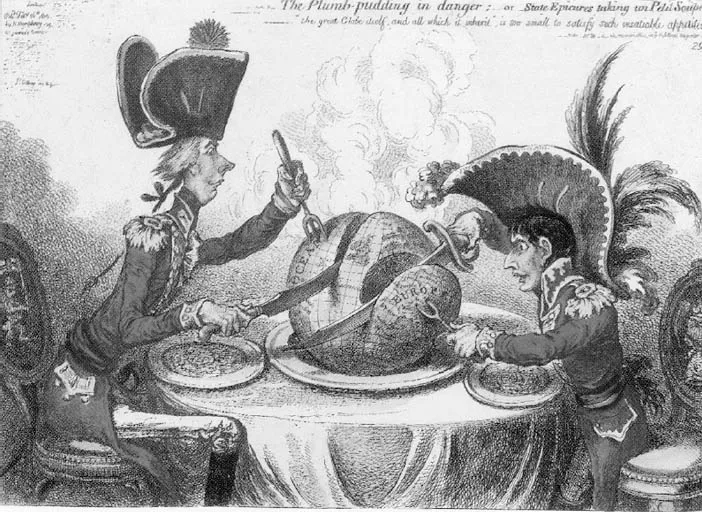
Figure 1.4 The Plum Pudding in Danger; or, State Epicures Taking un Petit Souper, by James Gillray, 26 February 1805. The cartoon depicts the rivalries over territory between Napoleon and Pitt. Each is seated with the globe served up on a platter like a plum pudding. Napoleon’s sword has sliced off France, Holland, Spain, Italy and Prussia, while his fork is dug spitefully into Hanover (then an appendage of the British crown). Pitt’s fork (trident) is stuck in the ocean as he carves the globe down the middle
For both geographers and cartographers, the map has served in various roles; as archive for geo-referenced data, as picture of the spatial order of the world, as tool for investigating spatial relations, and as an object of aesthetic and historical interest. The map has long been an object of fascination and value and is, for many geographers, the first picture they choose to decorate their offices and their books. In a deep professional and intellectual sense, the geographical imagination is one that is historically and personally identified with the cartographic image (Figure 1.5).
It is the drawing and interpreting of a line that marks the cartographic impulse. What does it mean to draw and interpret a line, to make and use a map, to dwell in the cartographic imagination? What are we to make of a map such as that in Figure 1.6, drawn by my 7-year-old son to explain the rules and strategies of the newly learned game of Four Square? In what ways have mapping skills, abstract reasoning and spatial thinking so come to shape the world of a 7-year-old, that the creation and use of such a map as a device of complex and detailed explanation can already be such ‘second nature’? The geographer Jim Blaut was convinced of the deeply imprinted nature of such mapping skills in children, and he understood well, I think, the deeply historical and material origins of such cultural practices (Blaut 1991). In this broadest of senses, he understood what it means to speak of geographical knowledge in a world so thoroughly suffused with carto-graphies of one kind or another, and how cartographic reason has contributed to the ways in which we dwell historically and geographically on the earth (see Blaut 1993). Nearly twenty years earlier Zelinsky (1973: 1) had been blunt in his assessment of the state of our understanding of the significance and reach of this particular form of cultural politics when he argued that ‘we have as yet no truly adequate definition of the map; and we have scarcely begun the serious study of its grammar. Thus we do not really know the fundamental nature of the thing we are so intimately enmeshed with, nor do we know what it is we really see or how we think when we look at it.’
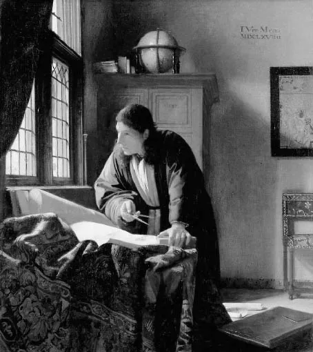
Figure 1.5 The Geographer, Vermeer (oil on canvas, 1668–9) (Stadelsches Kunstinstitut und Galerie, Frankfurt am Main, with permission)
Figure 1.6 ‘Four square’ (7-year-old Leon, with permission)
Ten years ago I could also write that ‘the theory of maps has received comparatively...
Table of contents
Cover Page
Half Title page
Title Page
Copyright Page
Dedication
One pylon marks the spot
Contents
List of illustrations
Preface and acknowledgements
Part I Introduction
Part II Deconstructing the map
Part III The over-coded world A genealogy of modern mapping
Part IV Investing bodies in depth
Part V Conclusion
Notes
References
Index
Frequently asked questions
Yes, you can cancel anytime from the Subscription tab in your account settings on the Perlego website. Your subscription will stay active until the end of your current billing period. Learn how to cancel your subscription
No, books cannot be downloaded as external files, such as PDFs, for use outside of Perlego. However, you can download books within the Perlego app for offline reading on mobile or tablet. Learn how to download books offline
Perlego offers two plans: Essential and Complete
Essential is ideal for learners and professionals who enjoy exploring a wide range of subjects. Access the Essential Library with 800,000+ trusted titles and best-sellers across business, personal growth, and the humanities. Includes unlimited reading time and Standard Read Aloud voice.
Complete: Perfect for advanced learners and researchers needing full, unrestricted access. Unlock 1.5M+ books across hundreds of subjects, including academic and specialized titles. The Complete Plan also includes advanced features like Premium Read Aloud and Research Assistant.
Both plans are available with monthly, semester, or annual billing cycles.
We are an online textbook subscription service, where you can get access to an entire online library for less than the price of a single book per month. With over 1.5 million books across 990+ topics, we’ve got you covered! Learn about our mission
Look out for the read-aloud symbol on your next book to see if you can listen to it. The read-aloud tool reads text aloud for you, highlighting the text as it is being read. You can pause it, speed it up and slow it down. Learn more about Read Aloud
Yes! You can use the Perlego app on both iOS and Android devices to read anytime, anywhere — even offline. Perfect for commutes or when you’re on the go. Please note we cannot support devices running on iOS 13 and Android 7 or earlier. Learn more about using the app
Yes, you can access A History of Spaces by John Pickles in PDF and/or ePUB format, as well as other popular books in Technology & Engineering & Historical Geography. We have over 1.5 million books available in our catalogue for you to explore.