![]()
Part I
CONQUEST
In recent years, students of Roman provincial history have increasingly been moving away from traditional political-military accounts to examine social issues and the acculturation of indigenous peoples under Roman domination. This is a productive trend, to which the present writer subscribes, and indeed a large part of this book is dedicated to the makeup of provincial society and its integration into the Roman world. But the image of rapid and willing romanisation, propagated by writers under the Early Empire and frequently echoed in the modern literature, belies an embarrassing truth. Assimilation of the recalcitrant peoples of Spain became possible only after a bitter struggle of unprecedented length, in which the Romans suffered many defeats and on several occasions achieved success only through treachery. There could hardly be a greater contrast between Gaul, which Caesar conquered in ten years, and Spain, which defied Rome’s best generals, including Caesar, for two centuries. Any attempt to write a social history of Spain in the Republican period is ultimately frustrated by the complete absence of Iberian literary sources, the almost total lack of epigraphic evidence, and the Roman writers’ concentration on military affairs. Yet even if we had complete sources, the fact would remain that for most of the period from 218 to 16 bc Spain was a war zone, and despite incipient assimilation behind the frontier, the struggle against Rome was a concern that dictated the lives, and often deaths, of many Spaniards. The prolonged military struggle is an inseparable component of the history of Roman Spain, and to this extent the ancient historians were justified in their theme. Yet, consistent with the annalistic historiography of their day, they were more interested in recording what happened than in examining why. While the failure of specific campaigns can be attributed to the incompetence of individual generals, the overall length of the conquest can be explained by two factors beyond Roman control: the unyielding nature of the Spanish terrain, which throughout history has given tremendous advantages to the defender while hindering the communications and supply lines of the attacker; and the warlike background and tribal ethos of the indigenous peoples, who combined haughty spirit with guerrilla tactics to keep the invader at bay for so long. Any account of the conquest of Spain must begin by considering the land and its pre-Roman inhabitants.
CHRONOLOGY OF THE CONQUEST
| 8th–4th c. BC | Tartesos flourishing |
| 226 BC | Ebro treaty |
| 218–202 BC | Second Punic War |
| 206 BC | Carthaginians expelled from Spain |
| 197 BC | Spanish provinces created |
| 195 BC | Cato governor of Citerior |
| 179 BC | Gracchus governor of Citerior |
| 155–139 BC | Lusitanian War |
| 153–133 BC | Celtiberian War |
| 138–136(?) BC | Brutus’ campaigns in north-west |
| 80–73 BC | Sertorian revolt |
| 49–45 BC | Civil War |
| 26–16 BC | Cantabrian War |
![]()
1
THE PENINSULA AND ITS INHABITANTS
THE IMPACT OF GEOGRAPHY
Few lands of the ancient world present sharper physical contrasts than the Iberian peninsula. Extremes of elevation, of climate, of vegetation have exercised a profound influence on social and economic development through the ages. The sheer size of the peninsula (581,000 km2, or double the area of Italy), the diversity of its topography and the intractibility of its inhabitants have always posed an obstacle to political and cultural unity. Its roughly quadrilateral shape (fancifully likened to an oxhide by ancient Greek geographers) would have been more conducive to internal communications than the tenuous Italian peninsula, were it not for the rugged terrain of the interior and the winter snows which annually block the mountain passes.
‘Africa begins at the Pyrenees,’ declares an old proverb, whose validity is hardly confined to Spain’s notorious summer temperatures. Iberia is not only a peninsula but a virtual subcontinent. The Pyrenees, Spain’s only land link to the rest of Europe, serve more as a barrier than a corridor, except at their coastal extremities. On the other hand, the Straits of Gibraltar – known to the Romans as the fretum Gaditanum because of their proximity to Cádiz – form a natural bridge with Africa. Attached by land until probably the end of Pliocene times (roughly two million years ago), the straits were easily traversed by Paleolithic man, Carthaginians and Arabs. The narrow crossing – about 14 km at the shortest point, grossly underestimated by Pliny at 5–7 Roman miles – was aptly nicknamed the ‘step-across’ (transgressio).1 Here stood the Pillars of Hercules – Calpe (Gibraltar) on the Spanish side, Abila (Ceuta) on the African – one of the most famous landmarks of the ancient world, and revered in superstition as the point beyond which man must not sail.2 Because of their shallowness, the straits all but sever the warm Mediterranean from the cold Atlantic, forming the practically tide-less ‘lake’ which the Romans called ‘our sea’.
The variety of the Spanish landscape is the product of an underlying geographical diversity. The dominant structural feature is the Meseta, an extensive inland plateau covering between one-third and one-half of the peninsula, with an average height of some 600 m. It is bounded on three sides by mountains: the Cantabrian Cordillera to the north, the Iberian range to the north-east and east, the Sierra Morena to the south, the last two being separated by the grassy steppe of Albacete. On the western flank, however, the low mountains of eastern Portugal, pierced by the Douro and Tejo river valleys, pose a slighter obstacle, while to the south-west the declining Meseta gradually blends into the dry and uninviting plateaus of Extremadura. Further south, beyond the Guadalquivir depression, the Baetic Cordillera stretches from Gibraltar to Cape de la Nao on the east coast, and ultimately, submerged, to the Balearic Islands. Though Alpine in structure and containing the peninsula’s highest peak (Mulhacén in the Sierra Nevada, at 3,480m), the Baetic Cordillera is punctuated by gaps which render it a less effective barrier than the Pyrenees.
In pointed contrast to the lofty tableland of central Spain is the narrow coastal plain which surrounds it. Whereas the mountains enclosing the Meseta have always been an impediment to penetration, the low Mediterranean coast has throughout history acted as a cultural sponge, successively absorbing and assimilating Iberians, Phoenicians, Greeks, Romans, Goths and Arabs. The eastern shore of Spain in particular offers a flat, easily travelled corridor as far south as Valencia and (after skirting the Baetic massif projecting at Cape de la Nao) Cartagena. The Atlantic seaboard beyond the Gulf of Cádiz was less frequented and relatively unimportant until the fifteenth century. From Ossonoba (Faro) the Roman road turned abruptly inland, meeting the littoral only at the ports of Olisipo (Lisbon, in the estuary of the Tejo) and Cale (Oporto, at the mouth of the Douro) and at Brigantium (La Coruna), site of a renowned lighthouse which survives in modified form.
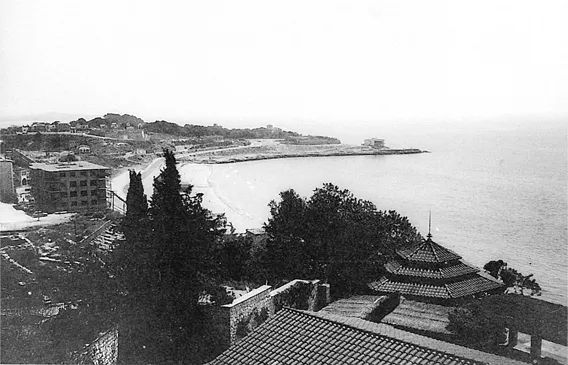
Today, while the Atlantic coastline of the peninsula offers several good natural harbours, the same can scarcely be claimed for the Mediterranean side. In antiquity, however, the east coast of Spain was considerably more hospitable to shipping. The Massiliot colony of Emporion (Empúries) on the Gulf of Roses enjoyed a sheltered harbour, which has since become clogged with sand. The Iberian town and Roman colony of Ilici was situated on the Vinalopo river, emptying into the now dessicated Ilicitanus sinus; its maritime entrepôt was the recently excavated site of Santa Pola, near the entrance to this gulf. The Punic port of Carthago Nova (Cartagena), still an important naval and commercial harbour, was even more capacious in Roman times. The Phoenician settlement at Malaca (Málaga) had a harbour reinforced by sea walls, of which only slight traces have survived the ravages of nature.3 But not all ancient ports could boast these advantages. Tarraco (Tarragona), capital of Hispania Citerior, was little more than an open beach (Figure 1.1), though important as the terminus of the Republican land route from Italy; Strabo notes that it sits on a bay but has no harbour. Although ships could be beached here, it is perhaps significant that in 210 BC Scipio preferred to disembark at Emporion and continue to Tarraco on foot.4 The colonies of Valentia (Valencia), Dertosa (Tortosa) and Barcino (Barcelona) were more important for their location at river mouths than for the quality of their harbour facilities; Barcelona had a notoriously poor harbour even in its medieval heyday. On the other hand, Dianium (Denia) and Lucentum (Alicante) had excellent harbours which were still important in Muslim times.
Of the five principal rivers crossing the peninsula, four (the Guadalquivir, Guadiana, Tajo/Tejo and Duero/Douro) flow towards the Atlantic, away from the Roman world. Only the Ebro, the largest in volume of the peninsula’s rivers, empties directly into the Mediterranean. All five, while subject to serious flooding on occasion, fulfil a crucial role in transporting the agrarian and mineral products of the interior to the sea. Two of the three Roman provincial capitals were situated on these major rivers: Corduba (Córdoba) on the Guadalquivir, Augusta Emerita (Mérida) on the Guadiana. Other important fluvial ports included Hispalis (Seville) on the Guadalquivir and Caesaraugusta (Zaragoza) on the Ebro. Although the major waterways mostly flowed westward, there were several smaller rivers draining into the Mediterranean, with harbours at their mouths, as well as the important river Ebro which emptied into the Mediterranean at Tortosa, which now lies several kilometers inland as a result of subsequent silting.
The climate of the peninsula is as varied as the topography, and determines in large measure its agricultural potential. While modern weather statistics can provide only an approximation of ancient climate, there is little reason to doubt that conditions in Roman times were analogous to today’s. Despite modest glacial fluctuations (such as the ‘little Ice Age’ of the period 1550–1850, which in Spain witnessed several severe floods and the unprecedented freezing of the lower Guadalquivir), the Mediterranean is still in the sub-Atlantic climatic phase which began around 700 BC.5 Southern Spain (Andalusia) and the east coast enjoy a Mediterranean climate, temperate for the most part, though in the south, summer temperatures sometimes reach 45°C. Average annual rainfall is 500–600 mm in Andalusia, 500–800 in Catalonia; but the south-east coast from Almena to Alicante, facing the Sahara, receives less than 300 mm and has the only subdesert climate in Europe. The central Meseta has a continental climate, bitterly cold in winter (-20° at Teruel), uncomfortably sultry in summer (40°), with 300–600 mm rainfall. The north coast and the northern half of the west coast (beginning around Coimbra) have an Atlantic or oceanic climate marked by relatively cool temperatures but heavy rainfall (in excess of 1,000 mm). This pluviose or humid zone stands in abrupt contrast to the semi-arid conditions prevalent in most of the peninsula.
Figure 1.1 The beach and bay of Tarraco, capital of Hispania Citerior.
The soils of the peninsula, while derived from the underlying bedrock, owe their formation largely to the action of wind and water. In the northern Meseta, ancient and modern rivers have carved deep ravines through the limestone crust, exposing the cultivable marls and clays below. Frequent flooding of the numerous tributaries north of the Duero has created the fertile, if dry, alluvial plains of the Tierra del Pan and Tierra de Campos. The southern Meseta is more varied, comprising three distinct zones. On the west is the Extremadura, a plateau system of rugged metamorphic rock laced with quartzite, extending into eastern Portugal. The centre-east region, known as New Castile, is reminiscent of the northern Meseta, with marls capped by eroded limestone. The alluvial valleys of the Tajo and its tributaries slice through both these terrains. The south-eastern zone of the Meseta constitutes the flat, arid plain of La Mancha. The coastal strip of Portugal is composed largely of sandstone, in many places topped by rich alluvium. Andalusia features the rich, black alluvial deposits of the Guadalquivir basin, as well as heavier clays (tirs) which in summertime can bake into a hard, impermeable crust. Typical of the east coast, and of the sub-Baetic hills stretching from Cádiz to Alicante, is the famed terra rossa. This calcareous red clay (whose colour is due to iron oxides) is highly supportive of grain and fruit farming, but vulnerable to erosion. The east coast is also cut by several alluvial river valleys, of which the most extensive by far is the triangular basin of the Ebro. In contrast to these dry soil types are the brown, siallitic soils of the rainy Cantabrian littoral and the acidic soils of the north-west (Galicia). In the damp Galician lowlands are found peat soils, while on the better-drained plateaus, frequent rainfall has created podsol, leached of lime and other minerals.6
In antiquity, much of the peninsula was covered with coniferous and deciduous forest, notably pine and oak. The denudation of these woods in Roman and later times has produced serious erosion, though substantial stands of natural timber still persist in Galicia and on isolated mountain slopes. The evergreen holm-oak, once ubiquitous in Iberia, is particularly well suited to the dry Mediterranean climate. In the highlands are found Pyrenean oak, beech and pine; the last of these also abounds in the sandy soils around Segovia. Deciduous trees like chestnut and oak flourish on the coastal plains, while the famous cork oak is plentiful in south-western Spain and Portugal. The Meseta, now given over largely to scrub, was formerly capable of supporting extensive woodlands. In arid south-eastern Spain, the hinterl...