![]()
1
GREEK EXPLORATION BEFORE 500BC
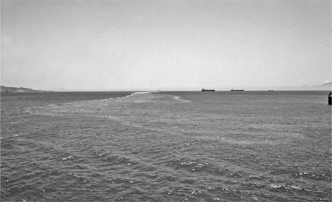
To the Greeks the sea now called the Mediterranean was the Great Sea,1 or, more tellingly, the Internal Sea or the Inside Sea,2 since at first it seemed to have no outlet. In fact there were two. To the northeast was the long narrow treacherous channel of the Hellespont and Bosphoros, leading to another enclosed sea, the Euxeinos – perhaps Persian aesaena, “dark” or “sombre” – or Black Sea,3 which, although not mentioned in Greek literature until Herodotos,4 was probably first explored a little after 700BC. Greeks discovered the western outlet at about the same time, sailing far beyond the Greek heartland.5 At the westernmost extremity of the Great Sea were two prominent mountains, which at an early date came to be called the Stelai, or Pillars, of Herakles (Figure 1), so named because it was believed that this was the farthest point that the hero had reached.6 Although there was some confusion as to exactly what constituted the Pillars, they are generally thought to be the two prominent peaks flanking the Mediterranean that today bear Islamic names: to the south Jebel Musa (862m elevation), and 30 miles to the north Gibraltar, corrupted from Jebel Tariq (423m elevation). These mark the entrance to a long passage, the Herakleian or Gadeian Strait (Figure 2).7 It was as narrow as seven miles across and ran somewhat south of west for 35 miles. Sailors passing through the straits would find the water turning from blue to a less benign green, and increased swell and tidal phenomena.8 Eventually they would be outside the Internal Sea and in a different world, where one could not only be out of sight of land, but be so forever, eternally lost in the great Ocean that encircled the world, on which sea travel was not advisable.9 The Ocean could not be crossed,10 for the gods would not allow it.11
Figure 1 The Pillars of Herakles. View east toward the Mediterranean.
Photograph by Duane W. Roller.
Figure 2 The Herakleian Strait. View from Africa to Europe.
Photograph by Duane W. Roller.
It is not known exactly when the first Greek ventured beyond the Pillars into that portion of the Ocean that came to be named after Atlas.12 There was a tradition that Odysseus had reached Spain, but this is not documented before Roman times.13 Yet Homeric references to strange celestial phenomena may be among the first reports of the far reaches of the world – the close day and night of the Laistrygonians14 and the eternal darkness of the Kimmerians15 – although both passages are shrouded in obscurity and may be nothing more than a description of the mythical world beyond human knowledge where everything is reversed. Similar are the Fortunate Islands or Islands of the Blessed, the legendary place of reward for those given an eternity of bliss, which steadily moved west just ahead of seamen’s knowledge. They are first mentioned in Greek literature by Hesiod, already outside the Pillars of Herakles.16 Although mythical, they were a strong force in Greco-Roman conceptions of and interest in the Atlantic, and they influenced patterns of exploration well into Roman times.
The first Greek documented to have gone beyond the Pillars is Kolaios of Samos.17 His story, known solely from Herodotos, was one of the most excessive examples of a voyage badly gone off course. Kolaios was a merchant captain on the Samos–Egypt run who was blown to Platea, east of Kyrene. In attempting to return to his route he was driven by a constant easterly wind so far that he passed through the Pillars – some 1,100 miles to the west – and ended up in the district of Tartessos on the southwestern coast of Spain, which Greeks allegedly had never previously visited, although it was vaguely known to them.18 Kolaios returned home with 60 talents’ worth of wealth.19 His voyage can be fairly precisely dated to around 630BC because it was contemporary with the founding of Kyrene.20
There is something suspicious about the journey. It is difficult to imagine a constant east wind for the days or weeks necessary, too remindful of the storm that assailed Odysseus for nine straight days.21 It is striking that Kolaios made no attempt to reconnoiter during the frequent times that he must have been in sight of land. Moreover, his original detour to Platea was remarkably convenient, removing him from the areas in which he was known and bringing him into contact with another adventurous seaman, one Korobios, who may have told Kolaios about the riches of Tartessos. Despite Herodotos’ assertion that no Greek had previously visited Tartessos, this may be what he was told by his Samian sources in an attempt to give themselves priority. The wealth of Tartessos was probably already known to the Greek world, perhaps from the Phoenicians,22 and it seems that Kolaios knew exactly where he was going and why, but attributed his trip to an accident,23 one of the earliest examples of the familiar theme of a momentous discovery that was credited to being off course but which had an aura of premeditation.24
Tartessos was a mineral-rich district of southwestern Spain whose primary products were tin and silver.25 The Phoenicians had established a trading post at nearby Gadir – Gadeira or Gades, modern Cadiz – allegedly shortly after the Trojan War, although archaeological evidence suggests that the foundation was not until the eighth century BC.26 Tartessos became a prosperous trading center, and knowledge of it and its wealth penetrated east: the earliest reference may be to biblical Tarshish, one of the sources of the riches of Solomon.27 The lyric poet Stesichoros, of the early sixth century BC, seems to have been the first in Greek literature to cite it by name, although Strabo believed that Tartaros, the deepest reaches of the underworld, had been so named by Homer because he had heard of Tartessos.28
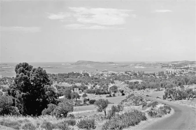
Kolaios’ return home to Samos and his deposit of a tenth of his profits in the Heraion made the wealth of Tartessos well known in the East Greek world.29 It was the Ionian city of Phokaia that was to exploit this knowledge, becoming the first Greek state to make long sea journeys.30 The Phokaians were believed to be Central Greek in origin – perhaps only because of the similarity of the name Phokis31 – and had settled in Ionia with Athenian help, perhaps as early as the ninth century BC.32 Their city was located on a small bay at the end of the peninsula that defines the north side of the Hermaian Gulf (Figure 3), at whose head is Smyrna. The site of Phokaia is marked by a promontory at the end of the peninsula, on which stood a temple to Athene.33 Before the city was destroyed by the Persians, it was one of the most impressive of Greek cities. The city walls had been constructed with money from Tartessos and became a conspicuous and enduring reminder of the western wealth.34 These walls, which are still visible, had made Phokaia one of the largest cities in the world.35 Excavation has also revealed remnants of a later temple, a theater of the fourth century BC, and tombs.36 The town and its name have survived and today it is the pleasant resort village of Foça. The modern visitor can only marvel at the impact on world exploration of this quiet and unprepossessing site.
Figure 3 Phokaia. View of site.
Photograph by Duane H. D. Roller.
The Phokaians had begun to explore the Mediterranean as early as the beginning of the seventh century BC: Herodotos emphasized the shipbuilding technology that made this possible. They participated in the emergent Egyptian trade soon after the founding of Naukratis by Miletos, joining other cities in building the Helleneion, the Ionian religious and trading center.37 The Phokaians also penetrated into the Black Sea.38 But it was in the western Mediterranean that their efforts were most impressive.39 As Herodotos recorded:40 “they discovered Adria, Tyrrhenia, Iberia, and Tartessos,” an impressive list that defines all the northwest quadrant of the Mediterranean as well as territory beyond the Pillars of Herakles. They were at Tartessos no later than the mid-sixth century BC, where they were befriended by the local king Arganthonios, who unsuccessfully attempted to persuade them to settle in his territory, and then financed the building of their city walls as defense against the Persians.41
The Phokaians founded many cities in the western Mediterranean, but none was as significant as Massalia. About 600BC, a Phokaian contingent led by a certain Euxenos discovered the site, having travelled over 1,000 miles from their homeland.42 Euxenos and his companions would have been sailing north along the coast when they came to an entrance that led to the southeast, b...