
- 352 pages
- English
- ePUB (mobile friendly)
- Available on iOS & Android
eBook - ePub
Decision Support Systems in Urban Planning
About this book
This book presents a set of selected and edited papers presented at the 2nd and 3rd Design and Decision Support Conference. The purpose is to provide examples of innovative research in decision support systems in urban planning from throughout the world.
Trusted by 375,005 students
Access to over 1 million titles for a fair monthly price.
Study more efficiently using our study tools.
Information
Topic
ArchitectureSubtopic
Urban Planning & LandscapingPART ONE: Theory
1: The design of spatial decision support systems in urban and regional planning
Bola Ayeni
INTRODUCTION
Planning methodology has changed over the years as emphasis has shifted from situations in which planners think, plan and design for the people, to one in which both people and planners have become important actors in the planning process. The arguments have been that planners do not necessarily have all the knowledge and the ability to perform planning tasks alone, and consequently should interact more with the people for whom the plan is being made. Indeed, the people consist of two groups: the decision-makers who eventually consider and approve plans, and the common people for whom the plans are being made. It is probably true to say that, for a long time, both groups of people have looked upon the planner as a technocrat whose main interest lies in imposing rules, laws and regulations without much consideration for the views of the people. The need to involve not only planners but also policy-makers in the planning process calls for the introduction of new planning approaches that integrate these three groups of people.
One way to integrate the actors in the planning process is through the use of spatial decision support systems, which in turn depends to a considerable extent on the development of user-friendly mathematical models through the use of expert systems. A major aim of this chapter is to outline the need for, and the incorporation and institutionalization of, decision support systems into an integrated spatial planning framework. Decision Support Systems in Urban Planning. Edited by Harry Timmermans. Published in 1997 by E & F N Spon. ISBN 0 419 21050 4 Consequently, we shall discuss the roles of geographical information systems (GIS) and the use of expert systems in facilitating these processes in urban and regional planning. In particular, we shall emphasize the fact that GIS needs many more improvements and innovations to be really useful to solve the sort of problems that planning urban development poses. We shall also show that the capability of GIS to communicate graphically and by visualization is not only an asset but could constitute the basis for the development of decision support systems. We shall also describe a prototype decision support system within the framework of mathematical modelling and spatial analysis.
SPATIAL DECISION SUPPORT SYSTEMS
Spatial decision support systems (SDSS) are off-shoots of decision support systems whose origins may be traced to the frustration with the use of management information systems in the cognate discipline of management science. However, decision support systems (DSS) are decision aids and occur in all areas of scientific analysis and investigation. As computer-based systems, decision support systems assist decision-makers in semi-structured tasks, support rather than replace judgement, and improve the effectiveness of decision-makers rather than its efficiency. A DSS assumes that there is no single solution or answer to a problem, but allows users to bring their expertise to the solution of the problem. In this way users are able to use intuition and expert judgement about ‘unmodellable’ aspects of the problem. Furthermore, since only one formulation of the problem is evaluated at any stage, the process allows groups to evaluate solutions and revise specifications of the problem. Decision support systems are designed to solve ill-or semi-structured problems, i.e. where objectives cannot be fully or precisely defined. They must have an interface that is both easy and powerful to use; enable the user to combine models and data in a flexible manner; and make full use of all the data and models that are available. Furthermore, they must help the user to explore the solution space (the options available to them) by using the models in the system to generate a series of feasible alternatives. Decision support systems support a variety of decision-making styles, and are easily adapted to provide new capabilities as the needs of the user evolve (Geoffrion, 1983).
Spatial decision support systems are decision support systems developed for use with a domain database that has a spatial dimension, or for situations where the solution space of a problem has a spatial dimension (Wright and Buehler, 1993, p. 123). Spatial decision support systems integrate a geographical information system with a computer-based spatial analysis module and map analysis and display modules. Such systems typically employ a personal computer in such a way that planning sce narios can be determined, analysed and adopted according to the planning standards that are being set up by planners and decision-makers. The use of these support systems is highly desirable when professional planners, politicians and decision-makers must act jointly to effect certain decisions.
Spatial decision support systems are computer programs designed to bring the whole of the knowledge base to bear on a problem through a flexible and adaptive solution system that makes explicit use of both the analysts' models and the expert knowledge of decision-makers. Definitions of spatial decision support systems (SDSS) often focus on their characteristics. Thus, an SDSS will provide database management, model base management, and graphical and tabular reporting capabilities under a unified and possibly intelligent user interface. Densham (1994) posits that, in general, a spatial decision support system will possess all of the following attributes:
- Support for the capture of spatial and non-spatial data
- Ability to represent complex spatial relations among spatial data that are needed for spatial query, spatial modelling and cartographic display
- A flexible architecture, enabling the user to combine models and data in a variety of ways
- Methods peculiar to spatial and geographical analysis, including spatial statistics
- Ability to generate a variety of outputs, including maps and other more specialized forms
- A single, integrated, user interface that supports a variety of decisionmaking styles
- An architecture that supports the addition of new capabilities as user needs evolve
A decision support system comprises three components: a knowledge subsystem, containing data and data manipulation procedures; a language subsystem, which is the user interface; and a problem processing subsystem, which links and coordinates models and data (Turban and Watkins, 1986). Spatial decision support systems are geared to solving specific problems and are designed to generate alternative solutions and incorporate performance criteria that are of interest to planners. They have an edge over conventional geographical information systems in that they incorporate a greater level of analytic and statistical modelling than is required to assist the process of decision-making. Furthermore, they are better than conventional modelling techniques because models are just part of the problem processing subsystem of a fully developed decision support system (Armstrong, 1993; Armstrong et al., 1993).
GEOGRAPHICAL INFORMATION SYSTEMS AND URBAN PLANNING
The 1960s and 1970s were periods of soul-searching for the planning profession in general and for urban and regional planning in particular. It was a time when serious attempts were made to evaluate the theoretical basis of planning as well as when computation became accepted as part of the sine qua non for rational decision-making. Nonetheless, the use of computations was fraught with numerous problems, some conceptual and others technical (Batty, 1993). The conceptual problems arise from notions not unrelated to issues of optimality in decision-making and the extent to which predictive models may be used as planning tools. On the other hand, the technical issues deal with the inadequacy of available data and the inability of computational methods to display and show results in forms easily amenable to the appreciation of decision-makers. As noted by Batty (1993), GIS shows promise in removing many of these problems because of its emphasis on visualization and communication.
The rational decision-making model of planning is based on the simple notion that the planning process embodies an analytical phase in which the problem is explored, followed by a synthetic base in which the solution is devised or generated. Problems are informed by data and survey relating to the issue in question, and progress towards the solution is cast in terms of general goals and more detailed objectives. The analysis involved is oriented towards generating a requisite understanding of the problem, thus enabling some prediction of immediate states of the system. In the synthetic phase, solution of the problems involves some intuition that generates a range of alternative scenarios, which are then evaluated simultaneously. Decisions are made to adopt and implement a particular plan based on these results. The iterative process involved in the solution phase allows the initial problem to be better defined and solutions better refined.
Urban models were thus seen as props around which such a rational planning process may be developed. For instance, urban models were informed by the nature of the problems at hand, and the goals and objectives of the planning process, which in turn inform the sort of models used to optimize alternative planning scenarios. Evaluation, choice and implementation were in turn informed by a variety of urban models (Fig. 1.1). Inevitably, this mode of planning depended and will continue to depend on a number of information systems that include management information systems, land information systems, and a variation of what we describe today as geographical information systems. This latter was made up of socioeconomic and physical information about various locations in the city as well as the transport system that linked them together and the cost of traversing space. Figure 1.1 provides a good description of this conception of the planning process.
Existing GIS contain only the most rudimentary of functions relevant to the sort of analytical, simulation and prediction and design tasks that dominate strategic planning. For instance, a typical urban planning problem will require the presence of a broad range of databases developed as information systems and at varying spatial scales and levels of variable aggregation. For example, at the urban planning level, we will be dealing with data and models whose basic unit would be either the street or network or a set of relevant attributes associated with some geometric area such as the block or the census tract. Various aggregations of zones will be required while different types of networks are needed. The set of information in a typical strategic planning situation will include demographic and economic data, land use data, transportation data and data concerning urban economic structure, all cast in the form of employment, population by age-sex group, and interactions of people, goods and information flows. Physical data pertaining to the quality of the landscape, topography, soils, geology, land use type and housing structures would also form part of the assembly (Batty, 1993). Only very few GIS can at present embrace this type of data and map it successfully, let alone develop this data for the various models and forecasting purposes required in urban and regional planning.
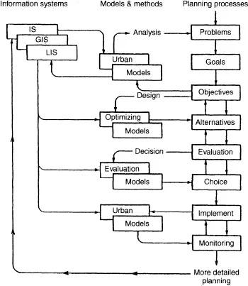
Fig. 1.1 Planning support systems incorporating models and information systems. (After Batty, 1993.)
Nonetheless, the process of planning within cities constitutes one of the best examples of dealing with loosely structured problems for a number of reasons. First, in any planning situation, there is considerable unmodelled information and knowledge on the part of the planners and decision-makers. Secondly, the urban planning process shows such variability and complexity to require judgement and experimentation with available tools. Furthermore, the decision-maker's definition of the problem and identification of key factors are continually being revised during investigation. Moreover, the problem is sufficiently ill-defined for a decision-maker to treat development of its solution as part of the problemsolving process. Requirements for modelling these types of situations must be treated as open-ended. Attempts in the past to see models as providing solutions to problems were therefore misplaced, as models can only be a decision aid. This is the essence of developing decision support systems.
Many GIS have emerged in areas of concern to planning, e.g. land use zoning, transportation planning, natural resource management, utility companies, etc. These are applications of GIS to subsets of the problems as in the case of the use of TransCAD for transport development issues or ARC/INFO, SPANS, etc., for numerous other applications. These functions, though useful in planning, are partial attempts, and so tend to be less important than those based on models, methods and design protocols. Consequently, they are not the ones to provide the lifeblood for urban and regional planning. As noted by Batty (1993), ‘the sort of functions which are required in urban planning and spatial policy analysis are usually absent from the archetypal GIS whose functionality embodying spatial analysis and modelling is weak’.
Nonetheless, there are important developments that cannot but change the way planning will be done in the future. Some of these pertain to the development of expert systems in various areas, the integration of which constitutes urban and regional planning. For instance, as far back as 1990, Kim et al. (1990) published a text that explored the use of expert systems technology in urban planning. In the last few years, there have been important and path-breaking studies in the development of expert systems for land use control (Leary, 1993), the checking of compliance with building codes (Heikkila et al., 1990), and local government planning (Davis and Gant, 1987). Indeed, expert systems are being developed in various areas of environmental planning (Wright et al., 1993). Added to these is the increasing application of the use of knowledgebased systems (Wright et al., 1993) to various aspects of the planning process, including transport systems and the review of environmental impact assessments. There is no doubt that plan...
Table of contents
- Cover Page
- Title Page
- Copyright Page
- Contributors
- Introduction
- Part One: Theory
- Part Two: Methodology
- Part Three: Application
Frequently asked questions
Yes, you can cancel anytime from the Subscription tab in your account settings on the Perlego website. Your subscription will stay active until the end of your current billing period. Learn how to cancel your subscription
No, books cannot be downloaded as external files, such as PDFs, for use outside of Perlego. However, you can download books within the Perlego app for offline reading on mobile or tablet. Learn how to download books offline
Perlego offers two plans: Essential and Complete
- Essential is ideal for learners and professionals who enjoy exploring a wide range of subjects. Access the Essential Library with 800,000+ trusted titles and best-sellers across business, personal growth, and the humanities. Includes unlimited reading time and Standard Read Aloud voice.
- Complete: Perfect for advanced learners and researchers needing full, unrestricted access. Unlock 1.4M+ books across hundreds of subjects, including academic and specialized titles. The Complete Plan also includes advanced features like Premium Read Aloud and Research Assistant.
We are an online textbook subscription service, where you can get access to an entire online library for less than the price of a single book per month. With over 1 million books across 990+ topics, we’ve got you covered! Learn about our mission
Look out for the read-aloud symbol on your next book to see if you can listen to it. The read-aloud tool reads text aloud for you, highlighting the text as it is being read. You can pause it, speed it up and slow it down. Learn more about Read Aloud
Yes! You can use the Perlego app on both iOS and Android devices to read anytime, anywhere — even offline. Perfect for commutes or when you’re on the go.
Please note we cannot support devices running on iOS 13 and Android 7 or earlier. Learn more about using the app
Please note we cannot support devices running on iOS 13 and Android 7 or earlier. Learn more about using the app
Yes, you can access Decision Support Systems in Urban Planning by Harry Timmermans in PDF and/or ePUB format, as well as other popular books in Architecture & Urban Planning & Landscaping. We have over one million books available in our catalogue for you to explore.