eBook - ePub
Hydropower in the New Millennium
Proceedings of the 4th International Conference Hydropower, Bergen, Norway, 20-22 June 2001
- 556 pages
- English
- ePUB (mobile friendly)
- Available on iOS & Android
eBook - ePub
Hydropower in the New Millennium
Proceedings of the 4th International Conference Hydropower, Bergen, Norway, 20-22 June 2001
About this book
The power sector has undergone a liberalization process both in industrialized and developing countries, involving market regimes, as well as ownership structure. These processes have called for new and innovative concepts, affecting both the operation of existing hydropower plants and transmission facilities, as well as the development and implementation of new projects. At the same time a sharper focus is being placed on environmental considerations. In this context it is important to emphasize the obvious benefits of hydropower as a clean, renewable and sustainable energy source. It is however also relevant to focus on the impact on the local environment during the planning and operation of hydropower plants. New knowledge and methods have been developed that make it possible to mitigate the local undesirable effects of such projects. Development and operation of modern power systems require sophisticated technology. Continuous research and development in this field is therefore crucial to maintaining hydropower as a competitive and environmentally well-accepted form of power generation.
Trusted by 375,005 students
Access to over 1.5 million titles for a fair monthly price.
Study more efficiently using our study tools.
Information
Development ofHydropower Technology and Design
Sedimentation in the Koka Reservoir, Ethiopia
Michael Abebe H.
Medium Scale Hydropower Study Project, Ministry of Water Resources, Ethiopia
Medium Scale Hydropower Study Project, Ministry of Water Resources, Ethiopia
ABSTRACT: Ethiopia is one of the few African countries that have great potential for producing hydroelectricity and irrigation development. The estimated total hydropower potential of Ethiopia is about 30–40GW; of this vast potential, only 1% has been utilized up to now and more than 87% of the country’s electricity out put is generated by hydroelectric facilities. Koka is the first large hydroelectric power plant established in Ethiopia. It was commissioned in May/June 1960 followed by Awash II and III cascade power plants and currently all the above three power plants supply about 26% of Ethiopian’s power production. According to a recent bathymetric survey, the capacity of Koka Reservoir has been reduced from 1667 Mm3 in 1959 to 1186 Mm3 in 1998. The loss on total capacity over 38 years is 481 Mm3 i.e., 28.9% of the total storage volume. The average annual loss of capacity is 0.74%. In this article it is attempted to discuss the impact, extent and alternative measures to prolong its service life.
1 INTRODUCTION
The Koka hydro power plant is located about 90km southeast of Addis Ababa, the capital city of Ethiopia. Awash and Mojo are the two main rivers which flow to the Koka Reservoir. The Awash River originates from the southwest highlands to the west of Addis Ababa. It flows in the southeast direction up to Melka gorge, where it starts changing its direction to the east and joins the Koka Dam. The Mojo River originates in the northeast highlands of Addis Ababa and flows to the south direction and joins the Koka reservoir.
The area is dominated by bimodal rainfall type with a small peak in April and maximum peak in August Due to the orographic effect, the rainfall pattern in the catchment area increases from east to west and the mean annual rainfall is 1012mm.
Land use in the area is mainly dominated by moderately to intensively cultivated subsistence based cropland, grazing land, settlement areas (Addis Ababa City and other small towns) and eucalyptus trees, shrubs and grass cover some parts of the highland areas. In addition to the swampy area that covers about 140 km of land, there are also small storage reservoirs (Legedadi, Gefersa, and Abasamuel) and small closed lakes basin in the catchment.
The geology of the basin is predominated by sedimentary rocks such as limestone and sandstone. Site investigation in the reservoir area carried out before the dam construction indicates that the area was swampy and alluvial plain, through which the river runs in meanders.
Key Power Plant Data
| Catchment area | 10747 km2 |
| Average annual runoff | 1601 Mm3 |
| Average annual flow | 51m3/s |
| Dam type | Concrete gravity dam |
| Dam crest level | 1593.2masl |
| HRWL | 1590.7masl |
| LRWL | 1580.7masl |
| Intake level | 1570.9masl |
| Maximum storage | 1667 Mm3 |
| Reservoir area at HRWL | 171 km2 |
| Tunnel length | 71.5m |
| Diameter | 5.5m |
| Capacity | 127m3/s |
| Penstock (No.) | 3 |
| Installed capacity | 43MW |
| Number of units | 3 |
| Type of turbine | Francis |
2 SEDIMENT YIELD
Sediment yield of a catchment area can be determined by periodic sampling of the river flow to measure sediment concentration for various water discharges. There are a number of ways to characterize the sediment loads of rivers. Among these, for computation of sediment yield in the design of a water resource project, considerations are usually given to suspended sediment load and bed load.

The conventional method to determine sediment load in a river is to measure the concentration of suspended sediments in the river flow under various flow conditions by use of point-integrated or depth-integrated samples. In Ethiopia, the most usual method to collect suspended sediment yield is the depth- integrated sampler, i.e.; collecting samples at equally spaced stream vertical in the river cross section.
On the other hand, sediment is also carried by the river as bed load material. Although various types of bed load samplers have been designed and tested, there are no simple and reliable measuring techniques available for bed load sampling. The measurement of bed load transport presents many difficulties and results are frequently unreliable. Different researchers revealed that the bed load in a reservoir might vary the suspended load several times, though more commonly it lies between 5–25% range. In Ethiopia bed load is always assumed as a certain percentage of suspended load, which is usually 10–25%, depending upon various factors.
Suspended sediment load transported to the Koka Reservoir was estimated on the basis of sediment sampling carried out at both stations. The sediment concentration and water discharge relation for these stations were developed by the Ministry of Water Resources, Department of Hydrology and these equations are given below.
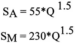
Where SA and SM are Suspended sediment load transported in Awash and Mojo rivers in ton/day; and Q is river discharge in m3/s.
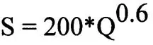
Similarly, the sediment sampling carried out at Wonji town, down stream of the dam, has the following rating equation and this was adopted to compute the out flow sediment load from the reservoir.
The grain size distribution obtained from suspended sediment sampling carried out in both rivers revealed that clay 55%, Silt 44.5% and Sand 0.5%. In addition to this, samples conducted in one of the Awash River tributaries, upstream of the dam, during pre construction period justified that the sediment load consists of mainly very uniformly graded silt nearly 60% of the total load (Norcosult, 1957). Similarly, the geo-technical investigation carried out in the reservoir area at the same period also identified alluvial deposit of about 19m thick clay and some small zones of sand and tuff.
Thus, it can be concluded that the dominant sediment particles in the reservoir are clay and silt. Since bed load measurements haven’t been carried out either in the rivers nor in the reservoir, the total sediment load (suspended + Bed load) entering the reservoir should be estimated on basis of suspended sediment load. Fan and Morris (1998) suggested that if the stream bed material is dominated by clay and silt without sand, the bed load is <2% of the suspended load. However, as the sediment load o...
Table of contents
- Cover
- Half Title
- Title Page
- Copyright Page
- Table of Contents
- Preface
- Organization
- Acknowledgements
- Illustration
- New Trends in the Development of Hydropower Projects
- Recent Trends in Operation of Hydropower Plants
- Hydropower as Environment Sustainable Generation
- Development of Hydropower Technology and Design
- Authors index
Frequently asked questions
Yes, you can cancel anytime from the Subscription tab in your account settings on the Perlego website. Your subscription will stay active until the end of your current billing period. Learn how to cancel your subscription
No, books cannot be downloaded as external files, such as PDFs, for use outside of Perlego. However, you can download books within the Perlego app for offline reading on mobile or tablet. Learn how to download books offline
Perlego offers two plans: Essential and Complete
- Essential is ideal for learners and professionals who enjoy exploring a wide range of subjects. Access the Essential Library with 800,000+ trusted titles and best-sellers across business, personal growth, and the humanities. Includes unlimited reading time and Standard Read Aloud voice.
- Complete: Perfect for advanced learners and researchers needing full, unrestricted access. Unlock 1.5M+ books across hundreds of subjects, including academic and specialized titles. The Complete Plan also includes advanced features like Premium Read Aloud and Research Assistant.
We are an online textbook subscription service, where you can get access to an entire online library for less than the price of a single book per month. With over 1.5 million books across 990+ topics, we’ve got you covered! Learn about our mission
Look out for the read-aloud symbol on your next book to see if you can listen to it. The read-aloud tool reads text aloud for you, highlighting the text as it is being read. You can pause it, speed it up and slow it down. Learn more about Read Aloud
Yes! You can use the Perlego app on both iOS and Android devices to read anytime, anywhere — even offline. Perfect for commutes or when you’re on the go.
Please note we cannot support devices running on iOS 13 and Android 7 or earlier. Learn more about using the app
Please note we cannot support devices running on iOS 13 and Android 7 or earlier. Learn more about using the app
Yes, you can access Hydropower in the New Millennium by B. Honningsvag, G.H. Midttomme, K. Repp, K. Vaskinn, T. Westeren, B. Honningsvag,G.H. Midttomme,K. Repp,K. Vaskinn,T. Westeren in PDF and/or ePUB format, as well as other popular books in Biological Sciences & Civil Engineering. We have over 1.5 million books available in our catalogue for you to explore.