- 348 pages
- English
- ePUB (mobile friendly)
- Available on iOS & Android
eBook - ePub
Geology and Sedimentology of the Korean Peninsula
About this book
Written by one of Korea's most respected earth scientists, Geology and Sedimentology of the Korean Peninsula analyzes sedimentary facies, basin evolution, and sequence stratigraphy to provide answers to depositional processes and environmental changes through the Earth's history, including tectonic events, climate changes, and sea-level fluctuations. This is one of the first books covering the geology of the Korean peninsula. It offers an in-depth exploration of this region, which also allows comparison with sedimentary basins around the world. This is an important book for students, researchers, and professionals working in the geography of East Asia.
The study of sedimentary basins can help advance basic understanding of how the Earth's crust developed, as well as offer insights into the influence of environmental and climate change. Sedimentary basins are also of interest due to their importance in the exploration and recovery of natural resources, including oil and gas, water, and industrial minerals.
- Provides fundamental information on the geology of East Asia
- Serves as a guide for integrated sedimentary basin analysis, providing a detailed aid for comparative research
- Contains over 200 figures to illustrate the analysis
Trusted by 375,005 students
Access to over 1.5 million titles for a fair monthly price.
Study more efficiently using our study tools.
Information
Topic
Physical SciencesSubtopic
Geology & Earth Sciences1
Introduction
1.1 Geological Questions
The Korean Peninsula consists of scenic mountains and valleys that run one after another (Figures 1.1–1.3). These features have descended from crustal deformation and the associated plutonic and volcanic activities. Rivers run through the valleys, carrying sediments mostly toward the west and the south, forming floodplains. Where the rivers meet the coastal plain, estuaries form. Along the western and southern coasts of the peninsula, tidal flats are extensive, rivaling those of the North Sea and the Bay of Fundy. The Yellow Sea is a shallow (55 m on average) epicontinental sea, surrounded by the landmass of China and Korea. Off the western and southern coasts of the peninsula, there are more than 3000 islands. However, the eastern continental shelf is narrow and transitional to a bowl-shaped deep basin, the Ulleung Basin, and the Korea Plateau, which are dotted by numerous volcanic seamounts and islands, including the Ulleung and Dok islands (Figure 1.4). The volcanic island of Jeju comprises a central crater, about 360 scoria cones, and tuff rings and cones.
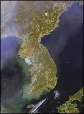
Figure 1.1 Satellite image of the Korean Peninsula. The peninsula consists largely of mountains (about 65%). There are about 3000 islands off the south and west coasts. Source: GOCI/COMS RGB Color Composite Image processed by Korea Ocean Satellite Center/Korea Ocean Research and Development Institute.
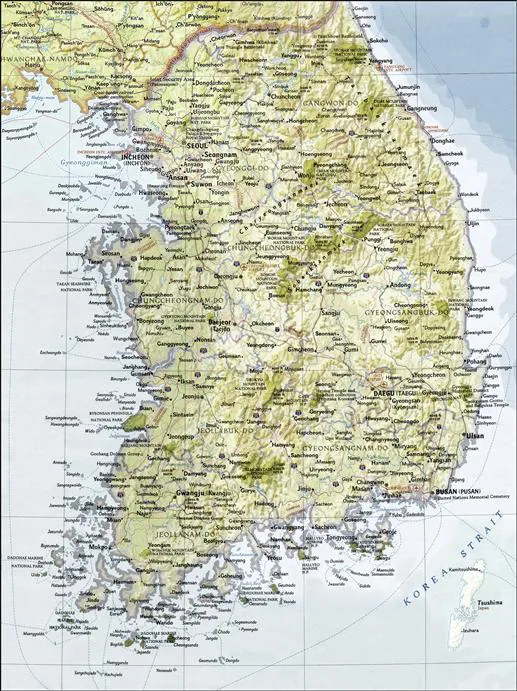
Figure 1.2 Geographic map of South Korea. Source: National Geographic (2003) by permission of the National Geographic Society.
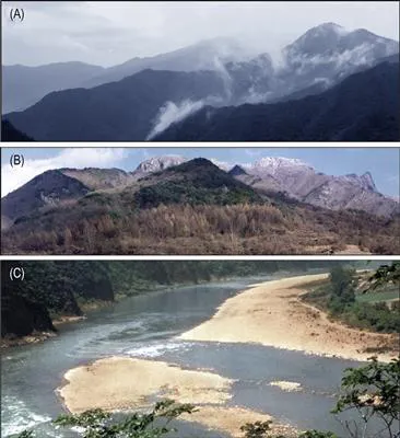
Figure 1.3 (A) View of a mountain chain in the southeast of Taebaek city, Gangwon Province. The ridges comprise sedimentary rocks (limestone and sandstone) that formed in shallow water environments during the Paleozoic (about 520–250 Ma) and deformed in the Mesozoic (ca. 250–150 Ma). The mountains represent remnant of continuous denudation for the last 150 million years. (B) Snow covered Wolak mountain in the background. It consists of granite intruded into metasedimentary rocks. (C) The meandering East River showing mid-channel and sidebars of gravelly sands.
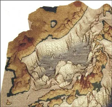
Figure 1.4 Topographic relief of the Korean Peninsula and the northeast Asian margin. Source: Courtesy of K. Tamaki.
The Korean Peninsula comprises denudation remnant of deformed basement rocks and sedimentary successions, concealing a long history of crustal deformation (Figure 1.5). Sedimentary rocks especially contain records of environmental change through Earth’s history, including climate change, the rise and fall of sea level, and the movement of tectonic plates over millions of years. The peninsula presents a number of fundamental questions as to its origin and dynamic processes. What constitutes the scenic mountains and ridges? When and how did these mountain chains form? Was it due to the collision of the tectonic plates? How often was the continent submerged under the sea throughout Earth’s history? How are the rocks in the peninsula linked to those of China and Japan? What are the origins of the deep basins and submarine plateaus in the East Sea? How did the continent under the Yellow Sea form and evolve? How would the coastal areas be affected by sea-level change over timescales of a few decades to centuries? These are commonly asked questions regarding dynamic processes and environmental changes of the Korean Peninsula on land and under the sea.
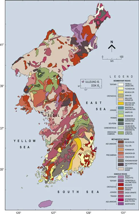
Figure 1.5 Geologic map of the Korean Peninsula. Source: Korea Institute of Energy and Resources (1981) by permission of the Korea Institute of Geoscience and Mineral Resources.
1.2 Sedimentary Facies Analysis
Sedimentary rocks are important constituents (more than 50%) of the crust of the Korean Peninsula. Sedimentary rocks (and sediments) are characterized by grain size and sedimentary structures, i.e., sedimentary facies, defined as a depositional unit characterized by a particular combination of grain size (lithology) and sedimentary (physical and biological) structures (Figure 1.6). Each unit of sedimentary facies represents distinct depositional processes that act on the sediments in particular environments (Figure 1.7). Genetically related facies can form a group, defined as a facies association or a sequence that has some environmental significance. An analysis of sedimentary facies thus leads the way to diagnosing depositional processes and environments (Dalrymple, 2010).
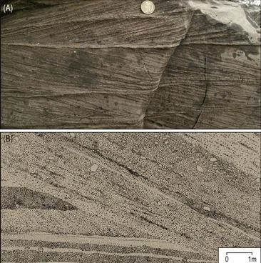
Figure 1.6 Sedimentary facies. (A) Bidirectional cross-bedded sandstone, Mantou Formation, Shandong Province, China. (B) Line drawing of large-scale scour at the base of foreset. The lower left part is characterized by cross stratified, disorganized, and openwork amalgamated beds of conglomerates similar to Gilbert-type topset facies. The foreset is characterized by steeply inclined beds of stratified and inversely graded conglomerates, Doumsan Fan Delta, Pohang Basin.
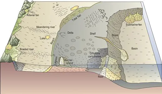
Figure 1.7 A large-scale view of depositional environments on Earth’s surface.
Sedimentary facies analysis is essential to the study of stratigraphy, which is primarily concerned with the recognition of distinct bodies of rocks in a chronological framework. A lithostratigraphic unit is defined by its lithologic characteristics in stratigraphic position relative to other bodies of sedimentary rock. A sedimentary rock unit can also be characterized by its fossil contents, biostratigraphy. Various other methods have also been used to define stratigraphic units, including magnetostratigraphy and chemostratigraphy.
Sedimentary facies analysis leads to an understanding of controls on basin evolution, including tectonics, climate changes, and sea-level changes (Miall, 2000, 2010). Plate movement causes subsidence of the crust, which provides the space for the accumulation of sediments. Sedimentary basins are commonly formed according to the plate tectonic regime: divergent, convergent, transcurrent, intraplate, and hybrid settings. Subsidence is induced by a thinning of the crust due to stretching, erosion, and magmatic withdrawal as well as tectonic and sedimentary loading and others (Busby and Azor, 2011). Uplift/subsidence also affects climate changes and the amounts of sediment supply. Along with these factors, sea-level changes control depositional processes and environments, especially in the shoreline and shallow waters.
Sedimentary facies analysis eventually leads to sequence stratigraphy, which is the study of rock relationships within a chronostratigraphic framework of repetitive, genetically related strata bounded by surfaces of erosion or nondeposition, or their correlative conformities (Posamentier et al., 1988; Van Wagoner et al., 1990). Sequence stratigraphic analysis focuses on the geometric characters of stratal patterns and identifications of key surfaces to determine the chronological order of basin fills (Catuneanu, 2006; Emery and Myers, 1996). The underlying tenet of sequence stratigraphy was that a change in sea level would result in a change in stratal patterns, which could be compared among basins worldwide. This deductive generic view of sequence stratigraphy has hampered, however, to further process-based sedimentological approach to an integrated basin analysis. The high variability of bounding surfaces and stratigraphic units requires inductive analysis for individual rock records (Catuneanu et al., 2009, 2010). Modern sequence stratigraphy focuses on the changes in stratal stacking patterns in response to varying accommodation and sediment supply through time (Catuneanu et al., 2010; Miall, 2010). Attention is now given to the specifics of how stratal architecture can throw light on depositional processes and allogenic controls.
Over the past 30 years, extensive sedimentary facies analyses have been made in major sedimentary basins of the Korean Peninsula, including the siliciclastics, carbonates, and mixed siliciclastic–carbonate successions as well as the nonmarine deposits. The results have led to significant advancement in the understanding of depositional processes and environments as well as of dynamic crustal evolution of the peninsula on land and under...
Table of contents
- Cover image
- Title page
- Table of Contents
- Copyright
- Preface
- Acknowledgments
- 1. Introduction
- 2. Tectonic Setting
- 3. Phanerozoic Granites
- 4. Okcheon Basin
- 5. Taebaeksan Basin
- 6. North China Platform in Shandong Province
- 7. Pyeongan Supergroup
- 8. Tectonic Evolution
- 9. Gyeongsang Arc System
- 10. Other Cretaceous Basins
- 11. Tertiary Basins
- 12. East Sea
- 13. Jeju Island
- 14. Yellow Sea
- 15. Summary
- References
Frequently asked questions
Yes, you can cancel anytime from the Subscription tab in your account settings on the Perlego website. Your subscription will stay active until the end of your current billing period. Learn how to cancel your subscription
No, books cannot be downloaded as external files, such as PDFs, for use outside of Perlego. However, you can download books within the Perlego app for offline reading on mobile or tablet. Learn how to download books offline
Perlego offers two plans: Essential and Complete
- Essential is ideal for learners and professionals who enjoy exploring a wide range of subjects. Access the Essential Library with 800,000+ trusted titles and best-sellers across business, personal growth, and the humanities. Includes unlimited reading time and Standard Read Aloud voice.
- Complete: Perfect for advanced learners and researchers needing full, unrestricted access. Unlock 1.5M+ books across hundreds of subjects, including academic and specialized titles. The Complete Plan also includes advanced features like Premium Read Aloud and Research Assistant.
We are an online textbook subscription service, where you can get access to an entire online library for less than the price of a single book per month. With over 1.5 million books across 990+ topics, we’ve got you covered! Learn about our mission
Look out for the read-aloud symbol on your next book to see if you can listen to it. The read-aloud tool reads text aloud for you, highlighting the text as it is being read. You can pause it, speed it up and slow it down. Learn more about Read Aloud
Yes! You can use the Perlego app on both iOS and Android devices to read anytime, anywhere — even offline. Perfect for commutes or when you’re on the go.
Please note we cannot support devices running on iOS 13 and Android 7 or earlier. Learn more about using the app
Please note we cannot support devices running on iOS 13 and Android 7 or earlier. Learn more about using the app
Yes, you can access Geology and Sedimentology of the Korean Peninsula by Sung Kwun Chough in PDF and/or ePUB format, as well as other popular books in Physical Sciences & Geology & Earth Sciences. We have over 1.5 million books available in our catalogue for you to explore.