eBook - ePub
Paleomagnetism
Continents and Oceans
- 386 pages
- English
- ePUB (mobile friendly)
- Available on iOS & Android
eBook - ePub
Paleomagnetism
Continents and Oceans
About this book
Paleomagnetism is the study of the fossil magnetism in rocks. It has been paramount in determining that the continents have drifted over the surface of the Earth throughout geological time. The fossil magnetism preserved in the ocean floor has demonstrated how continental drift takes place through the process of sea-floor spreading. The methods and techniques used in paleomagnetic studies of continental rocks and of the ocean floor are described and then applied to determining horizontal movements of the Earth's crust over geological time. An up-to-date review of global paleomagnetic data enables 1000 million years of Earth history to be summarized in terms of the drift of the major crustal blocks over the surface of the Earth.
The first edition of McElhinny's book was heralded as a "classic and definitive text." It thoroughly discussed the theory of geomagnetism, the geologic reversals of the Earth's magnetic field, and the shifting of magnetic poles. In the 25 years since the highly successful first edition of Palaeomagnetism and Plate Tectonics (Cambridge, 1973) the many advances in the concepts, methodology, and insights into paleomagnetism warrant this new treatment. This completely updated and revised edition of Paleomagnetism: Continents and Oceans will be a welcome resource for a broad audience of earth scientists as well as laypeople curious about magnetism, paleogeography, geology, and plate tectonics.
Because the book is intended for a wide audience of geologists, geophysicists, and oceanographers, it balances the mathematical and descriptive aspects of each topic.
- Details the theory and methodology of rock magnetism, with particular emphasis on intrepreting crustal movements from continental and oceanic measurements
- Outlines Earth history for the past 1000 million years, from the Rodinia super-continent through its breakup and the formation of Gondwana to the formation and breakup of Pangea and the amalgamation of Eurasia
- Provides a comprehensive treatment of oceanic paleomagnetism
- Provides a set of color pateogeographic maps covering the past 250 million years
- Written by two internationally recognized experts in the field
Trusted by 375,005 students
Access to over 1.5 million titles for a fair monthly price.
Study more efficiently using our study tools.
Information
Chapter One
Geomagnetism and Paleomagnetism
1.1 Geomagnetism
1.1.1 Historical
The properties of lodestone (now known to be magnetite) were known to the Chinese in ancient times. The earliest known form of magnetic compass was invented by the Chinese probably as early as the 2nd century B.C., and consisted of a lodestone spoon rotating on a smooth board (Needham, 1962; see also Merrill et al., 1996). It was not until the 12th century A.D. that the compass arrived in Europe, where the first reference to it is made in 1190 by an English monk, Alexander Neckham. During the 13th century, it was noted that the compass needle pointed toward the pole star. Unlike other stars, the pole star appeared to be fixed in the sky, so it was concluded that the lodestone with which the needle was rubbed must obtain its “virtue” from this star. In the same century it was suggested that, in some way, the magnetic needle was affected by masses of lodestone on the Earth itself. This produced the idea of polar lodestone mountains, which had the merit at least of bringing magnetic directivity down to the Earth from the heavens for the first time (Smith, 1968).
Roger Bacon in 1216 first questioned the universality of the north-south directivity of the compass needle. A few years later Petrus Peregrinus questioned the idea of polar lodestone deposits, pointing out that lodestone deposits exist in many parts of the world, so why should the polar ones have preference? Petrus Peregrinus reported, in his Epistola de Magnete in 1269, a remarkable series of experiments with spherical pieces of lodestone (Smith, 1970a). He defined the concept of polarity for the first time in Europe, discovered magnetic meridians, and showed several ways of determining the positions of the poles of a lodestone sphere, each method illustrating an important magnetic property. He thus discovered the dipolar nature of the magnet, that the magnetic force is both strongest and vertical at the poles, and became the first person to formulate the law that like poles repel and unlike poles attract. The Epistola bears a remarkable resemblance to a modern scientific paper. Peregrinus used his experimental data as a source for new conclusions, unlike his contemporaries who sought to reconcile observations with pre-existing speculation. Although written in 1269 and widely circulated during the succeeding centuries, the Epistola was not published in printed form under Peregrinus’ name until 1558.
Magnetic declination was known to the Chinese from about 720 A.D. (Needham, 1962; Smith and Needham, 1967), but knowledge of this did not travel to Europe with the compass. It was not rediscovered until the latter part of the 15th century. By the end of that century, following the voyages of Columbus, the great age of exploration by sea had begun and the compass was well established as an aid to navigation. Magnetic inclination (or dip) was discovered by Georg Hartmann in 1544, but this discovery was not publicized. In 1576 it was independently discovered by Robert Norman. Mercator, in a letter in 1546, first realized from observations of magnetic declination that the point which the needle seeks could not lie in the heavens, leading him to fix the magnetic pole firmly on the Earth. Norman and Borough subsequently consolidated the view that magnetic directivity was associated with the Earth and began to realize that the cause was not the polar region but lay closer to the center of the Earth.
In 1600, William Gilbert published the results of his experimental studies in magnetism in what is usually regarded as the first scientific treatise ever written, entitled De Magnete. However, credit for writing the first scientific treatise should probably be given to Petrus Peregrinus for his Epistola de Magnete; Gilbert, whose work strongly influenced the course of magnetic study, must certainly have leaned heavily on this previous work (Smith, 1970a). He investigated the variation in inclination over the surface of a piece of lodestone cut into the shape of a sphere and summed up his conclusions in his statement “magnus magnes ipse est globus terrestris” (the Earth globe itself is a great magnet). Gilbert’s work, confirming that the geomagnetic field is primarily dipolar, thus represented the culmination of many centuries of thought and experimentation on the subject. His conclusions put a stop to the wild speculations that were then common concerning magnetism and the magnetic needle. Apart from the roundness of the Earth, magnetism was the first property to be attributed to the body of the Earth as a whole. Newton’s theory of gravitation came 87 years later with the publication of his Principia.
1.1.2 Main Features of the Geomagnetic Field
If a magnetic compass needle is weighted so as to swing horizontally, it takes up a definite direction at each place and its deviation from geographical or true north is called the declination (or magnetic variation), D. In geomagnetic studies D is reckoned positive or negative according as the deviation is east or west of true north. In paleomagnetic studies D is always measured clockwise (eastwards) from the present geographic north and consequently takes on any angle between 0° and 360°. The direction to which the needle points is called magnetic north and the vertical plane through this direction is called the magnetic meridian. A needle perfectly balanced about a horizontal axis (before being magnetized), so placed that it can swing freely in the plane of the magnetic meridian, is called a dip needle. After magnetization it takes up a position inclined to the horizontal by an angle called the inclination (or dip), I. The inclination is reckoned positive when the north-seeking end of the needle points downwards (as in the northern hemisphere) or negative when it points upwards (as in the southern hemisphere).
The main elements of the geomagnetic field are illustrated in Fig. 1.1. The total intensity F, declination D, and inclination I, completely define the field at any point. The horizontal and vertical components of F are denoted by H and Z. Z is reckoned positive downwards as for I. The horizontal component can be resolved into two components, X (northwards) and Y (eastwards). The various components are related by the equations:
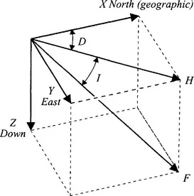
Fig. 1.1 The main elements of the geomagnetic field. The deviation, D, of a compass needle from true north is referred to as the declination (reckoned positive eastwards). The compass needle lie...
Table of contents
- Cover image
- Title page
- Table of Contents
- Inside Front Cover
- Copyright page
- Preface
- Chapter 1: Geomagnetism and Paleomagnetism
- Chapter 2: Rock Magnetism
- Chapter 3: Methods and Techniques
- Chapter 4: Magnetic Field Reversals
- Chapter 5: Oceanic Paleomagnetism
- Chapter 6: Continental Paleomagnetism
- Chapter 7: Paleomagnetism and Plate Tectonics
- References
- Index
- International geophysics series
Frequently asked questions
Yes, you can cancel anytime from the Subscription tab in your account settings on the Perlego website. Your subscription will stay active until the end of your current billing period. Learn how to cancel your subscription
No, books cannot be downloaded as external files, such as PDFs, for use outside of Perlego. However, you can download books within the Perlego app for offline reading on mobile or tablet. Learn how to download books offline
Perlego offers two plans: Essential and Complete
- Essential is ideal for learners and professionals who enjoy exploring a wide range of subjects. Access the Essential Library with 800,000+ trusted titles and best-sellers across business, personal growth, and the humanities. Includes unlimited reading time and Standard Read Aloud voice.
- Complete: Perfect for advanced learners and researchers needing full, unrestricted access. Unlock 1.5M+ books across hundreds of subjects, including academic and specialized titles. The Complete Plan also includes advanced features like Premium Read Aloud and Research Assistant.
We are an online textbook subscription service, where you can get access to an entire online library for less than the price of a single book per month. With over 1.5 million books across 990+ topics, we’ve got you covered! Learn about our mission
Look out for the read-aloud symbol on your next book to see if you can listen to it. The read-aloud tool reads text aloud for you, highlighting the text as it is being read. You can pause it, speed it up and slow it down. Learn more about Read Aloud
Yes! You can use the Perlego app on both iOS and Android devices to read anytime, anywhere — even offline. Perfect for commutes or when you’re on the go.
Please note we cannot support devices running on iOS 13 and Android 7 or earlier. Learn more about using the app
Please note we cannot support devices running on iOS 13 and Android 7 or earlier. Learn more about using the app
Yes, you can access Paleomagnetism by Michael W. McElhinny,Phillip L. McFadden, Renata Dmowska,James R. Holton,H. Thomas Rossby in PDF and/or ePUB format, as well as other popular books in Ciencias físicas & Geología y ciencias de la Tierra. We have over 1.5 million books available in our catalogue for you to explore.