eBook - ePub
The Western Alps, from Rift to Passive Margin to Orogenic Belt
An Integrated Geoscience Overview
- 432 pages
- English
- ePUB (mobile friendly)
- Available on iOS & Android
eBook - ePub
The Western Alps, from Rift to Passive Margin to Orogenic Belt
An Integrated Geoscience Overview
About this book
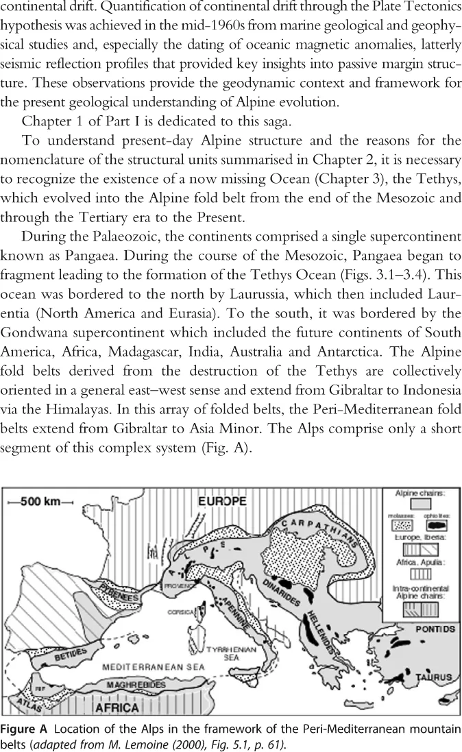
The Western Alps, from Rift to Passive Margin to Orogenic Belt addresses the evolution of the Alpine fold belt for the first time in the English language. It builds on classical Alpine geological studies made since the start of the 19th century by combining that research with modern results obtained over the past 50 years using new marine geological and geophysical technologies. The book thus provides an integrated overview of the evolution of the Alps from rift to passive margin to the present fold belt over a significant time span.
- An integrated multidisciplinary synthesis of the evolution of the Alps from rift to passive margin to foldbelt
- 175 figures, structural maps and cross sections
- An index of localities referred to in the fext and figures
- A brief summary of the history and development of ideas concerning the evolution of fold belts and passive margins since the 19th century
- Provides basis for further enquire and research
- Provides wider context relevant to marine and oil industry geoscientists
Trusted by 375,005 students
Access to over 1.5 million titles for a fair monthly price.
Study more efficiently using our study tools.
Information
Topic
Physical SciencesSubtopic
Geology & Earth SciencesPart One
Introduction
Introduction
Chapter One
Geosynclines, Passive Margins, Foreland Basins and Folded Belts
An Introduction
Pierre-Charles De Graciansky; David G. Roberts; Pierre Tricart Ecole Nationale Supérieure des Mines de Paris (France)
University of London, Egham, Surrey (United Kingdom)
University of Grenoble (France)
University of London, Egham, Surrey (United Kingdom)
University of Grenoble (France)
Publisher Summary
This chapter discusses geosynclines, passive margins, foreland basins, and folded belts. Application of the geosynclinal model provided guidelines for geological exploration and thinking in different fold belts worldwide and particularly those surrounding the Mediterranean. The shallow Moho under rifts and passive margins shows stretching of the crust and lithosphere. Foreland basins are associated with continental collision and formed by flexure of the lithosphere. They are elongated basins that thicken toward the adjoining contemporaneous fold or orogenic belt. The deflection of the lithosphere that forms the accommodation space infilled by foreland basin sediments is determined by the flexural rigidity of the lithosphere and the magnitude of the load imposed by the orogenic belt or wedge. The chapter also describes the Wilson cycle from the mountain belts, passive margins, and foreland basin-folded belts.
1 Prologue
Although geological sampling of surficial sediments in shallow and deep water dates back to the Challenger expedition in the 19th century, detailed studies of continental margins did not begin until after World War II. While early gravity expeditions led by Meinesz (1941) among others had yielded some insights into the deeper structure of the margins of the Pacific and Atlantic Oceans, the use of sonar and other techniques developed during the war allowed for rapid mapping of the sea floor and also investigation of the deeper structure beneath the shelf continental slope and abyssal plains.
It had long been recognized that pelagic sediments identified by the Challenger expedition (Murray and Renard 1891) had their equivalents in folded belts. However, the range of possible interpretations remained large especially in view of the then established view of the permanence of the ocean basins. Simplicity versus complexity were the two bywords that differentiated the community of marine geoscientists from those concerned with terrestrial geology and geoscience.
Suess in his seminal global geology summary (1885) noted that ‘the possibility was recognised of deducing from the uniform strike of the folds of a mountain chain, a mean general direction or trend line: such trend lines were seldom seen to be straight but consisted of arcs or curves, often violently bent curves of accommodation; the trend lines of central Europe were observed to possess a certain regular arrangement and to be traceable in part as far as Asia. It was further recognised that the ocean from the mouth of the Ganges to Alaska and to Cape Horn is bordered by folded mountain chains while in the other hemisphere this is not the case so thatPacific and Atlantic types may be recognised.’ Suess thus recognized, over a hundred years ago, the fundamental differences between the active (Pacific) and passive (Atlantic) continental margins. He noted the continuity of the circum Pacific and Alpine–Himalayan fold belts whose association with calc alkaline volcanism and deep earthquakes is now very well known and understood. Suess was also well aware of the problems of major marine transgressions especially that of the Late Cretaceous. However, Suess thought that the ocean crust was similar to that of the continents and that the oceans owed their origins to ‘subsidence and collapse’.
However, the technological hurdles that had to be overcome to determine the geology of continental margins were matched by the problems imposed by the complex and intense deformation of folded belts exposed on land.
2 Orogenesis, Rock Deformation and Development of the Thrust Concept
H.B. de Saussure (1740–1799), the Swiss naturalist from Geneva, was one of the first to express the idea that the torsion of beds observed on the flanks of Alpine valleys might be caused by ‘forcing back’ of rock material. His classic interpretation of the fold of the Arpenaz waterfall (Fig. 1.1) which dominates the Arve valley near the small town of Sallanches (between Chamonix and Geneva) was made, however, without any of the present knowledge of the rheological properties of rocks.
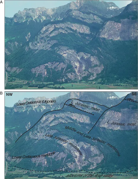
Figure 1.1 Fold of the Arpenaz waterfall, Haute Savoie (France). H.B. de Saussure (1740–1799), probably the first or among the first Alpine geologists, described the fold of the Arpenaz waterfall between Geneva and Chamonix in the Arve valley. To explain the observed deformation, he proposed that the Jurassic and Cretaceous limestones were soft muds at the time of deformation. Today, one of the interesting aspects of this fold is that it shows the divergence of structure towards the external part of the fold belt, here to the NW. Horace Benedict de Saussure (1790).
The permanence of continents and oceans was considered a basic truth by authors of the first three quarters of the 19th century. In consequence, they found difficulty in conceiving that the rocks forming the mountains had been subjected to horizontal displacements greater than those observed in associated folded beds. Not until the 1880s would the existence of thrusts be demonstrated clearly.
A comparison of concurrent structural interpretations of the Glarus area (Switzerland) classically exemplifies the debate at the end of the 19th century on this issue (Fig. 1.2).
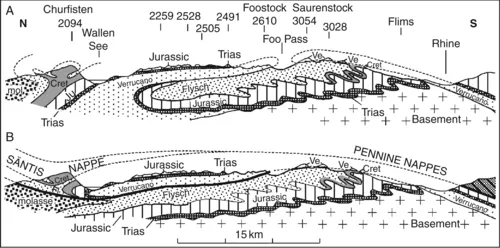
Figure 1.2 Two structural interpretations of the Glarus Alps. (A) Albert Heim sketched two large facing recumbent folds. A fan fold is required to explain the Churfisten structure on the left of section. The interpretation resolves the problem of abnormal superposition with respect to the normal way up succession at the same time minimizing the magnitude of the sub-horizontal tectonic transport of thrust material. The illustration provided by Heim in his 1878 paper is superb. It adopts and recaptures the earlier conclusions of Arnold Escher (1866). M: Molasse; f: Flysch; c: Cretaceous; J: Jurassic.; t Trias; p: Permian. From A. Heim 1878. (B) Marcel Bertrand introduced the notion of tectonic ‘covering’ originating the concept of the thrust nappe. He had not visited the field from the time of 1884 publication on the subject. He used structural results related to the coal basin of northern France to reinterpret the conclusions of A. Heim without contesting the validity of the observations. His sketch illustrates the concept according to which thrust nappes are derived by rupture of the inverse flank of a recumbent fold. From Marcel Bertrand (1883–1884), reproduced after Bailey (1935), Fig. 10, p. 40.
The interpretation of Heim (1891) which portrays two facing folded beds adroitly resolved the problem of abnormal superposition with respect to the normal bed succession while reconciling the intellectual requirement to minimize the amplitude of sub-horizontal displacements of rocks (Fig. 1.2A).
The 1884 interpretation of Bertrand in the same area subsequently gained the support of the community from the end of the 19th century. This described one of the first Alpine thrusts using modern extant ideas (Fig. 1.2B). From then on, classic thrust interpretations were made by great authors such as Schardt (1893) for the Prealps (Fig. 2.8), Lugeon (1902) for the Helvetic nappes, Termier (1903) for the Western Alps and for the Eastern Alps (Fig. 2.6A).
3 Mountain Belts and the Geosynclinal Theory (1859–1965)
The enormous thicknesses of sediments documented in fold belts and their adjacent basins caused major difficulties reconciled in the ‘geosynclinal’ theory (Fig. 1.3A) of Hall (1859) and Dana (1873). These thicknesses far exceeded the depths of the modern oceans and the sediments typically consisted of shallow marine deposits. Obviously subsidence had to have taken place to allow the accumulation of such thicknesses. Dana used the term ‘geosynclinal’ with reference to a subsiding and infilling basin resulting from his concept of crustal contraction due to a cooling earth.
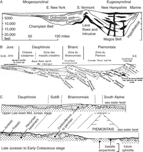
Figure 1.3 (A) Interpretation of the Appalachian system in Middle Ordovician time. This reconstruction derives from the Hall and Dana’s geosynclinal model. It has been the starting point for the interpretation of mountains for about a century (1858–1965). From Drake et al. (1959), Fig. 7, p. 7(B) Interpretation of the Alpine Geosynclinal, after Gignoux (1950). The Alpine geosynclinal model was taught from the 1930s to the end of the 1950s. It described a ‘geanticline’ for the Brianconnais cordillera characterized by littoral sediments (figured here by dotted lines) separating two troughs with thick sedimentation. This cordillera was identified as an ‘embryonic nappe’. Ophiolites were supposed to have been injected at the base of the internal cordillera, which formed another ‘...
Table of contents
- Cover image
- Title page
- Table of Contents
- Copyright page
- Dedication
- Foreword
- Acknowledgements
- List of Figures
- Part I: Introduction
- Part II: The Tethys Phase
- Part III: From the Tethys to the Alpine Fold Belt
- References
- Geographical Index
- Subject Index
Frequently asked questions
Yes, you can cancel anytime from the Subscription tab in your account settings on the Perlego website. Your subscription will stay active until the end of your current billing period. Learn how to cancel your subscription
No, books cannot be downloaded as external files, such as PDFs, for use outside of Perlego. However, you can download books within the Perlego app for offline reading on mobile or tablet. Learn how to download books offline
Perlego offers two plans: Essential and Complete
- Essential is ideal for learners and professionals who enjoy exploring a wide range of subjects. Access the Essential Library with 800,000+ trusted titles and best-sellers across business, personal growth, and the humanities. Includes unlimited reading time and Standard Read Aloud voice.
- Complete: Perfect for advanced learners and researchers needing full, unrestricted access. Unlock 1.5M+ books across hundreds of subjects, including academic and specialized titles. The Complete Plan also includes advanced features like Premium Read Aloud and Research Assistant.
We are an online textbook subscription service, where you can get access to an entire online library for less than the price of a single book per month. With over 1.5 million books across 990+ topics, we’ve got you covered! Learn about our mission
Look out for the read-aloud symbol on your next book to see if you can listen to it. The read-aloud tool reads text aloud for you, highlighting the text as it is being read. You can pause it, speed it up and slow it down. Learn more about Read Aloud
Yes! You can use the Perlego app on both iOS and Android devices to read anytime, anywhere — even offline. Perfect for commutes or when you’re on the go.
Please note we cannot support devices running on iOS 13 and Android 7 or earlier. Learn more about using the app
Please note we cannot support devices running on iOS 13 and Android 7 or earlier. Learn more about using the app
Yes, you can access The Western Alps, from Rift to Passive Margin to Orogenic Belt by Pierre-Charles de Graciansky,David G. Roberts,Pierre Tricart in PDF and/or ePUB format, as well as other popular books in Physical Sciences & Geology & Earth Sciences. We have over 1.5 million books available in our catalogue for you to explore.