eBook - ePub
About this book
During the past few decades, deep-sea research benefited greatly from a number of newly developed, highly sophisticated exploration techniques and comprehensive datasets, thanks to the immense industrial interest in deep-sea sediments.
The book Deep-Sea Sediments focuses on the sedimentary processes operating within the various modern and ancient deep-sea environments. The individual chapters track the way of sedimentary particles from continental erosion or production in the marine realm, to transport into the deep sea, to final deposition on the sea floor. The sedimentary processes cover several types of sediment gravity flow and contour currents, pelagic settling and hemipelagic advection, planktic and benthic bioproductivity, and volcanoclastic sedimentation. In addition, the relationships between depositional environment and endobenthic organisms as well as early diagenetic processes at and within the deep-sea floor are dealt with. Facies models of the wide range of depositional products hold the key for a process-related interpretation of ancient deposits. Changes in sea-water chemistry, major innovations in organism evolution, and changes in external controls on sedimentation and productivity are discussed in the context of overarching trends in ocean history.
Deep-sea sediments are not only of interest because of the numerous interacting processes involved in their formation, but they represent also a nearly inexhaustible archive of long-term climatic changes. Consequently, the book also includes an introduction to the climatic interpretation of the various proxies that reveal global changes during the Mesozoic greenhouse and Neogene icehouse conditions. In order to address the specific interest of the oil and gas industry in deep-water sediments, the investigation techniques that are applied in this context and the methods to predict both the occurrences and the characteristics of hydrocarbon reservoirs are included as well.
- Examines the rapidly evolving field of deep-sea sedimentary research
- Focuses on sedimentary and diagenetic processes, with theory and case histories
- Covers the climate record, hydrocarbon reservoirs, and other topics of interest
- Features a multimedia component with colour versions of figures
Tools to learn more effectively

Saving Books

Keyword Search

Annotating Text

Listen to it instead
Information
Chapter 1 Progress in Deep-Sea Sedimentology
1 Introduction
In this book, all marine domains extending seaward of the shelf break are considered as deep-sea. This domain represents 63.6 % of the Earth’s surface (the ocean in its entirety covers 361×106 km2 or 70.8% of the Earth’s surface, including continental shelves). From a stricter geological point of view, the oceanic domain would begin at the boundary between the high-density (3.25 on average), usually thin (5 km in average) oceanic crust and the thick (30 km on average) low-density (2.7 in average) continental crust. A transitional crust may exist in between.
The study of deep-sea sediments benefited greatly from recent improvements in technologies. These improvements have been driven by academic needs (most of the sea floor remains unexplored in detail and most of the topography of abyssal plains has not been mapped with accurate tools) and by economic needs, such as the demand for mineral deposits (metal-bearing nodules, exploration of ultra-deep offshore oil). These newly-developed technologies benefited from both in situ data collection and data interpretation in laboratory.
In terms of data collection, this includes:
– Sea-floor morphology (multibeam bathymetry),
– subsurface investigation (seismic tools),
– high-resolution echosounders,
– 3-D tools,
– sampling gear (interface corer).
In terms of data interpretation in the laboratory, this includes:
– core scanners for measurement of geotechnical and physical properties, X-ray, geochemistry,
– the development of biological tracers and biomarkers for palaeoenvironmental reconstruction,
– the improvement and development of stratigraphic tools and dating methods based on radiogenic and non-radiogenic elements (especially for the Quaternary), the development of micro-lithostratigraphy (IRD, tephra recognition) and magnetostratigraphy.
1.1 Scope of the book
The chapters of this book have the following objectives:
– to explain the formation and supply of sedimentary particles by continental erosion (river load, ice or wind transport), coastal erosion, current-induced winnowing, through volcanic and authigenic processes, and by means of biogenic productivity;
– to describe the way the sediments are transported from the source area (continental edge, slope, surface water) to the accumulation zone in the deep-sea;
– to present the early geochemical transformations affecting the particles in the water column or the sediments as soon as they are produced and accumulate on the sea floor;
– to show how sediments are preserved on the sea floor despite erosion and dissolution;
– to present the characteristic features and main changes in worldwide ocean sedimentation with focus on “modern” oceans that have been formed since the disintegration of Pangaea (Mesozoic-Cenozoic);
– to discuss major changes in biogenic productivity, sea-water chemistry, and external controls of deep-sea sedimentary processes, depending on long-term trends in ocean history;
– to present the academic (e.g., palaeoclimatic studies), societal (e.g., natural hazards) and industrial interests (e.g., the exploration for mineral resources) in the study of deep-sea sediments.
2 What are Deep-Sea Sediments?
The sea-water environment can be subdivided into shallow (epicontinental) seas and deep seas. The morphology of modern oceans and marginal seas is based on the water depth and on changes in the slope gradient (Fig. 1.1). Using a classical cross-section through a passive continental margin, the shallowest environment is the continental shelf (or platform), which extends in the continental domain from the shoreline to the shelf break. It represents 26×106 km2 (7.2% of the marine area). In this area, the sea-floor gradient is < 0.5°. In offshore direction, the water depth extends down to 100–110 m such as on the north-western African margin (Seibold and Hinz, 1974) or 200 m on most of the continental margins, including the northern European and the North-American Atlantic margins. Its extent can be from several hundreds of kilometres (1500 km for the Siberian shelf, > 600 km for the southern Argentina–Patagonian Shelf) to a few kilometres (off Nice in the Mediterranean). Active continental margins, such as the South-American Pacific margin, are usually only a few kilometres wide.
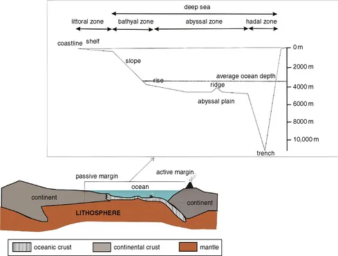
Figure 1.1 Cross-section through an ocean, showing the various deep-sea environments and domains. Lithosphere includes upper part of upper mantle plus oceanic or continental crust. (A multi-colour version of this figure is on the included CD-ROM.)
The continental shelf is exposed to numerous oceanographic processes that are absent in deep seas. Most of them are related to atmospheric processes. They include swell and storm waves that generate oscillatory motions in the water column (producing specific sedimentary structures such as hummocky cross-stratifications), tides, shallow contour currents, as well as shelf and coastal currents, including littoral drift. The continental shelf is separated from the continental slope by the shelf break, which is defined by a change in the slope gradient. The slope steepens from a gradient < 1° on the shelf to 3–5° in average along the slope, to sometimes more than 20° in areas where canyons are incised the slope and the shelf. Further downslope, it passes into the continental rise at a water depth of about 2500 m. The continental slope corresponds approximately to the bathyal zone (200–3000 m). On the rise, the slope gradient decreases to 1–2° and the relief becomes smoother. Because of this change, the continental rise is the preferential area for final deposition of terrigenous sediment that bypassed the shelf and slope area. Together, the continental shelf, slope and rise form the continental margin. The margin can be passive and tectonically quiescent (North Atlantic margin) or active and tectonically dynamic (circum-Pacific margins).
At about 5000 m water depth, the rise passes into the abyssal plain. Abyssal plains represent the largest oceanic domains with a mean water depth of ~ 3800 m. Abyssal plains are “flat” at a large scale. A closer look reveals, however, that their “flatness” is disrupted by tectonic and volcanic features: transform faults at different scales and strike-like faults with hanging walls of several hundreds of metres or even several kilometres in height and related local sedimentary basins. There are, in addition, hot-spot-related volcanic mounds and islands, volcano alignments forming the oceanic ridges, channels and thick and extensive accumulations of sediments forming drifts, and levees, gypsum diapirs; there are also dissolution structures. The continental rise and abyssal plains constitute the abyssal domain (3000–6000 m). Only 2% of the total ocean surface is deeper than 6000 m (hadal domain). In subduction areas, the presence of a subduction trench generates the deepest oceanic environments, down to 11,020 m (Mariana Trench). There, the presence of an accretionary prism can generate important relief-forming processes, such as mud diapirs and volcanoes (which may be related to the upward motion of deep fluids) and pockmarks, which are due to liquefaction related to fluid escape.
The sediments in the deep-sea consist of (1) clastic particles derived from eroded rocks and sediments outcropping either on the emerged continents or previously deposited in a marine environment, (2) particles formed by volcanic eruptions, (3) particles formed by living organisms, including organic matter, skeletal hard parts of calcareous, opaline or phosphatic composition, and faecal particles, and (4) particles formed by chemical precipitation of the elements contained in the salty sea water (average concentration of dissolved salts in sea water is 35.5 g/l). Most of chemical processes include microbiotic reaction...
Table of contents
- Cover
- Title Page
- Copyright
- Dedication
- Table of Contents
- Contributors
- Preface
- Chapter 1 Progress in Deep-Sea Sedimentology
- Chapter 2 Gravity Processes and Deposits on Continental Slope, Rise and Abyssal Plains
- Chapter 3 Contour Currents and Contourite Drifts
- Chapter 4 Pelagic Sedimentation in Modern and Ancient Oceans
- Chapter 5 Hemipelagic Advection and Periplatform Sedimentation
- Chapter 6 Benthic Deep-Sea Carbonates: Reefs and Seeps
- Chapter 7 Volcaniclastic Processes and Deposits in the Deep-Sea
- Chapter 8 Deep-Sea Ichnology: The Relationships Between Depositional Environment and Endobenthic Organisms
- Chapter 9 Early Diagenesis of Deep-Sea Sediments
- Chapter 10 Industrial Application of Deep-Sea Sediments
- Chapter 11 Mesozoic Pelagic Sediments: Archives for Ocean and Climate History during Green-House Conditions
- Chapter 12 Climate Records of Deep-Sea Sediments: Towards the Cenozoic Ice House
- Index
Frequently asked questions
Yes, you can cancel anytime from the Subscription tab in your account settings on the Perlego website. Your subscription will stay active until the end of your current billing period. Learn how to cancel your subscription
No, books cannot be downloaded as external files, such as PDFs, for use outside of Perlego. However, you can download books within the Perlego app for offline reading on mobile or tablet. Learn how to download books offline
Perlego offers two plans: Essential and Complete
- Essential is ideal for learners and professionals who enjoy exploring a wide range of subjects. Access the Essential Library with 800,000+ trusted titles and best-sellers across business, personal growth, and the humanities. Includes unlimited reading time and Standard Read Aloud voice.
- Complete: Perfect for advanced learners and researchers needing full, unrestricted access. Unlock 1.4M+ books across hundreds of subjects, including academic and specialized titles. The Complete Plan also includes advanced features like Premium Read Aloud and Research Assistant.
We are an online textbook subscription service, where you can get access to an entire online library for less than the price of a single book per month. With over 1 million books across 990+ topics, we’ve got you covered! Learn about our mission
Look out for the read-aloud symbol on your next book to see if you can listen to it. The read-aloud tool reads text aloud for you, highlighting the text as it is being read. You can pause it, speed it up and slow it down. Learn more about Read Aloud
Yes! You can use the Perlego app on both iOS and Android devices to read anytime, anywhere — even offline. Perfect for commutes or when you’re on the go.
Please note we cannot support devices running on iOS 13 and Android 7 or earlier. Learn more about using the app
Please note we cannot support devices running on iOS 13 and Android 7 or earlier. Learn more about using the app
Yes, you can access Deep-Sea Sediments by in PDF and/or ePUB format, as well as other popular books in Physical Sciences & Geology & Earth Sciences. We have over one million books available in our catalogue for you to explore.