- 472 pages
- English
- ePUB (mobile friendly)
- Available on iOS & Android
eBook - ePub
Field Guide to Rivers of North America
About this book
Based on the comprehensive, award-winning book Rivers of North America, the new Field Guide to Rivers of North America describes 200 of North America's most significant rivers in a reader-friendly, concise format. The guide is organized by geographic regions - each section begins with a map showing the relationship of rivers within one territory and a summary of the region's most important elements. Each individual river summary includes a two-page spread with a basin map, a full-color photograph and key river characteristics. The compact format of this guide will be particularly useful to scientists carrying out field research in areas such as field ecology, entomology, botany. It is an easy-to-use reference that can easily be packed away with other scientific gear. Anglers and recreational boating enthusiasts will find a wealth of information on river topography, native and nonnative fish species, as well as average temperatures that will help them plan their next adventure.The only field guide to cover this broad geographic area. Each river features:
- Color topographic river basin map
- Color photograph
- Precipitation graph
- Vital physical and biological statistics
Trusted by 375,005 students
Access to over 1.5 million titles for a fair monthly price.
Study more efficiently using our study tools.
Information
Topic
Physical SciencesSubtopic
Geology & Earth SciencesChapter 1
Introduction
Arthur C. Benke; Colbert E. Cushing
Freshwaters and the rivers that carry them are the continent’s most important natural resource in terms of natural biodiversity, a source of water for domestic consumption and irrigation, and various industrial uses. Rivers also happen to be one of the most dramatic features of a continent, are appreciated for their beauty, and often are used for fishing and recreation. They are the inevitable result of precipitation falling across the land, coalescing into streams, and uniting into ever larger streams and rivers. Over millions of years, these networks of flowing waters have delivered sediments and nutrients to downstream areas, sometimes eroding valleys and at other times depositing sediments, before eventually reaching the sea or an inland lake. This movement of water and material has helped shape the terrain, created a diversity of freshwater environments along its path, and allowed the evolution of thousand of species of plants, animals, and microbes. Together, these flowing water environments, with their uniquely adapted species, form the river ecosystems that we see today.
Given the enormous importance of rivers, the basic intention of this book is to present a compact guide to many of the major rivers of North America. This book is based on our Rivers of North America (Benke and Cushing 2005), which is a large reference volume of more than 1100 pages. The purpose of our 2005 book was to provide a better understanding of North American rivers and help lead to wiser management, sustainability, and restoration of these essential resources. The purpose of the present book is also to provide a better understanding of rivers, but intended to reach a wider audience. This Guide is essentially a distillation of the single-river summaries found in the 2005 book, arranged in the same regional chapters in an easily accessible format.
The North American continent contains a tremendous diversity of river sizes and types. Rivers range from the frigid and often frozen Arctic rivers of northern Canada and Alaska to the warm tropical rivers of southern Mexico. They range from the high-gradient turbulent rivers draining the western mountains to the low-gradient, placid rivers flowing across the southeastern Coastal Plain. River size ranges from what are essentially small streams to the enormous Mississippi, the 2nd longest river in the world, and the 9th largest by discharge (Leopold 1994). Such variations in latitude, topography, and size contribute to the great variation in biodiversity and ecological characteristics that we see among the continent’s rivers.
Total annual discharge from North American rivers is approximately 8,200 km3/yr or about 17% of the world total (Shiklomanov 1993). The Mississippi is by far the largest river, yet its mean discharge is only 7% of total continental discharge (580 km3/yr or 18,400 m3/s) (Shiklomanov 1993, Karr et al. 2000). Among the other top 25 rivers by discharge, more than a dozen have annual discharges greater than 2000 m3/s, with the largest being the St. Lawrence, Mackenzie, Ohio, Columbia, and Yukon (Table 1). All are rivers that flow to the sea, except the Ohio, which contributes almost half the flow of the Mississippi River. The Nelson and Missouri rivers are among the top five in drainage area, but only rank 11 and 15, respectively, in discharge because their basins receive only moderate precipitation. Three rivers with exceptionally large drainage basins, but not among the top 25 by discharge, are the Colorado, Rio Grande, and Arkansas (see bottom of Table 1). The Colorado and Rio Grande rivers each drain >600,000 km2 (among the top ten by basin area), but are located in arid regions, and have substantially lower discharge than many rivers draining much smaller basins. In addition to these extremely large rivers and river basins, there are many rivers of moderate-to-large size (100 to >1000 m3/s) that each flow for several hundred kilometers to the sea or are tributaries of larger rivers.
Table 1
Largest rivers of North America ranked by virgin discharge. All rivers may be found in this book except the Koksoak and La Grande.
| River Name | Discharge (m3/s) | Basin area (km2) | |
| 1 | Mississippi | 18,400 | 3,270,000 |
| 2 | St. Lawrence | 12,600 | 1,600,000 |
| 3 | Mackenzie | 9,020 | 1,743,058 |
| 4 | Ohio | 8,733 | 529,000 |
| 5 | Columbia | 7,730 | 724,025 |
| 6 | Yukon | 6,340 | 839,200 |
| 7 | Fraser | 3,972 | 234,000 |
| 8 | Upper Mississippi | 3,576 | 489,510 |
| 9 | Slave (Mackenzie basin) | 3,437 | 606,000 |
| 10 | Usumacinta | 2,687 | 112,550 |
| 11 | Nelson | 2,480 | 1,072,300 |
| 12 | Liard (Mackenzie basin) | 2,446 | 277,000 |
| 13 | Koksoak (Quebec) | 2,4201 | 133,4002 |
| 14 | Tennessee (Ohio basin) | 2,000 | 105,870 |
| 15 | Missouri | 1,956 | 1,371,017 |
| 16 | Ottawa (St. Lawrence basin) | 1,948 | 146,334 |
| 17 | Mobile | 1,914 | 111,369 |
| 18 | Kuskokwim | 1,900 | 124,319 |
| 19 | Churchill (Labrador) | 1,861 | 93,415 |
| 20 | Copper | 1,785 | 63,196 |
| 21 | Skeena | 1,760 | 54,400 |
| 22 | La Grande (Quebec) | 1,7201 | 96,8662 |
| 22 | Stikine | 1,587 | 51,592 |
| 24 | Saguenay (St. Lawrence basin) | 1,535 | 85,500 |
| 25 | Susitna | 1,427 | 51,800 |
| Additional large basins | |||
| Rio Grande | ∼100 | 870,000 | |
| Colorado | 550 | 642,000 | |
| Arkansas | 1,004 | 414,910 | |
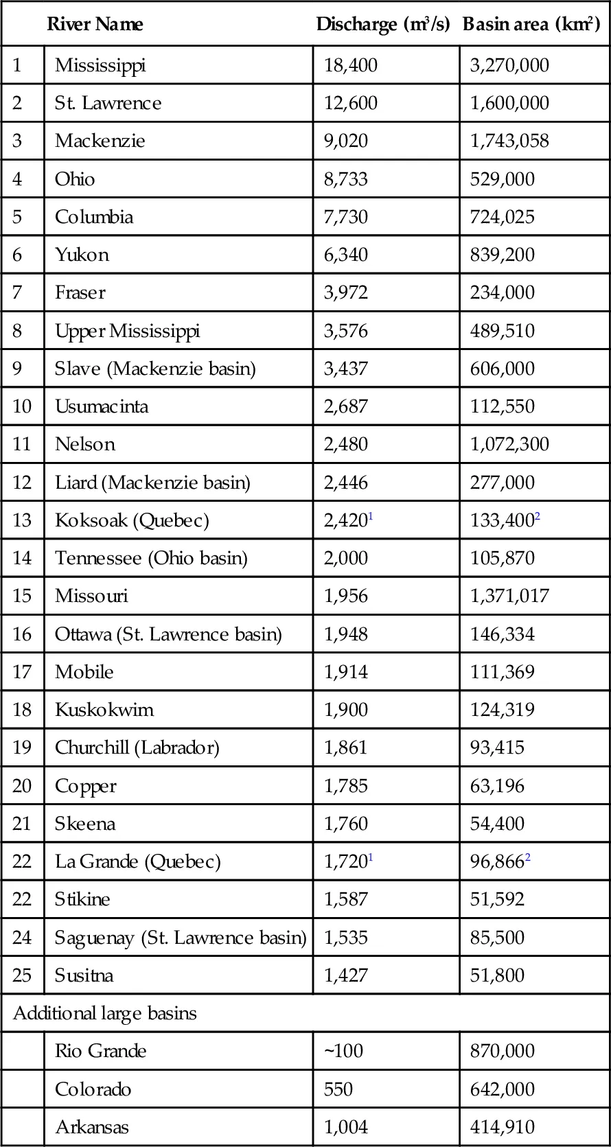
1 Dynesius and Nilsson (1994).
2 Leopold (1994).
Although humans have been attracted to rivers throughout North America for more than 12,000 years, it has not been until the past 100 years that industrialization has caused a radical transformation of most rivers. They have been dammed for flood control, hydropower, and navigation; dewatered for human and agricultural consumption; contaminated with waste products; and invaded by many nonnative specie...
Table of contents
- Cover image
- Title page
- Table of Contents
- Copyright page
- Preface
- Acknowledgements
- Chapter 1: Introduction
- Chapter 2: Atlantic Coast Rivers of the Northeastern United States
- Chapter 3: Atlantic Coast Rivers of the Southeastern United States
- Chapter 4: Gulf Coast Rivers of the Southeastern United States
- Chapter 5: Gulf Coast Rivers of the Southwestern United States
- Chapter 6: Lower Mississippi River and Its Tributaries
- Chapter 7: Southern Plains Rivers
- Chapter 8: Upper Mississippi River Basin
- Chapter 9: Ohio River Basin
- Chapter 10: Missouri River Basin
- Chapter 11: Colorado River Basin
- Chapter 12: Pacific Coast Rivers of the Coterminous United States
- Chapter 13: Columbia River Basin
- Chapter 14: Great Basin Rivers
- Chapter 15: Fraser River Basin
- Chapter 16: Pacific Coast Rivers of Canada and Alaska
- Chapter 17: Yukon River Basin
- Chapter 18: Mackenzie River Basin
- Chapter 19: Nelson and Churchill River Basins
- Chapter 20: Rivers of Arctic North America
- Chapter 21: Atlantic Coast Rivers of Canada
- Chapter 22: St. Lawrence River Basin
- Chapter 23: Rivers of Mexico
- Index of Rivers
Frequently asked questions
Yes, you can cancel anytime from the Subscription tab in your account settings on the Perlego website. Your subscription will stay active until the end of your current billing period. Learn how to cancel your subscription
No, books cannot be downloaded as external files, such as PDFs, for use outside of Perlego. However, you can download books within the Perlego app for offline reading on mobile or tablet. Learn how to download books offline
Perlego offers two plans: Essential and Complete
- Essential is ideal for learners and professionals who enjoy exploring a wide range of subjects. Access the Essential Library with 800,000+ trusted titles and best-sellers across business, personal growth, and the humanities. Includes unlimited reading time and Standard Read Aloud voice.
- Complete: Perfect for advanced learners and researchers needing full, unrestricted access. Unlock 1.5M+ books across hundreds of subjects, including academic and specialized titles. The Complete Plan also includes advanced features like Premium Read Aloud and Research Assistant.
We are an online textbook subscription service, where you can get access to an entire online library for less than the price of a single book per month. With over 1.5 million books across 990+ topics, we’ve got you covered! Learn about our mission
Look out for the read-aloud symbol on your next book to see if you can listen to it. The read-aloud tool reads text aloud for you, highlighting the text as it is being read. You can pause it, speed it up and slow it down. Learn more about Read Aloud
Yes! You can use the Perlego app on both iOS and Android devices to read anytime, anywhere — even offline. Perfect for commutes or when you’re on the go.
Please note we cannot support devices running on iOS 13 and Android 7 or earlier. Learn more about using the app
Please note we cannot support devices running on iOS 13 and Android 7 or earlier. Learn more about using the app
Yes, you can access Field Guide to Rivers of North America by Arthur C. Benke,Colbert E. Cushing in PDF and/or ePUB format, as well as other popular books in Physical Sciences & Geology & Earth Sciences. We have over 1.5 million books available in our catalogue for you to explore.