- 448 pages
- English
- ePUB (mobile friendly)
- Available on iOS & Android
eBook - ePub
About this book
The devastating impacts of tsunamis have received increased focus since the Indian Ocean tsunami of 2004, the most destructive tsunami in over 400 years of recorded history. The tsunamis that occurred as a result of the earthquake in Japan in March 2011 further emphasized the need for detection, monitoring, and early-warning technologies. This professional reference is the first of its kind: it provides a globally inclusive review of the current state of tsunami detection technology and will be a much-needed resource for oceanographers and marine engineers working to upgrade and integrate their tsunami warning systems. It focuses on the two main tsunami warning systems (TWS): International and Regional. Featured are comparative assessments of detection, monitoring, and real-time reporting technologies. The challenges of detection through remote measuring stations are also addressed, as well as the historical and scientific aspects of tsunamis.
- Offers readers the only source of practical content on the technological details of the subject
- Written by a tsunami detection and monitoring expert who has 32 years of experience in the field
- Companion web site featuring multi-media components, timely updates on fast-paced technological developments, and an online forum where scientists can exchange ideas, discuss technological updates and provide the author with valuable feedback
Trusted by 375,005 students
Access to over 1.5 million titles for a fair monthly price.
Study more efficiently using our study tools.
Information
Topic
Physical SciencesSubtopic
OceanographyChapter 1. Introduction
The oceans, which provide us with living and nonliving resources and regulate the weather, can be hostile at times. The August 27, 1883, tsunami (which was generated by the Krakatau volcano explosion in Indonesia) is the first known global tsunami (Symons, 1888; Choi et al., 2003; Pelinovsky et al., 2005). The May 22, 1960, Chilean tsunami is one of the most destructive trans-Pacific tsunamis and one of two known global tsunamis (Berkman and Symons, 1960; Wigen, 1960). The catastrophic and highly destructive December 26, 2004, Sumatra tsunami is the third known global tsunami, which severely damaged the coastal regions of the Indian Ocean, including those of 12 countries: Indonesia, Thailand, Myanmar, Malaysia, India, Sri Lanka, Bangladesh, Maldives, Somalia, Kenya, Tanzania, and South Africa. This tsunami killed more than 230,000 people; injured almost 283,000 people from about 60 countries; caused the deaths of nationals from 73 countries in this age of globalization and ecotourism; and left millions homeless and displaced (Stein and Okal, 2005; Lay et al., 2005; Titov et al., 2005; Rabinovich and Thomson, 2007). This is just one example of a tsunami's severe striking power. The Indian Ocean tsunami of December 26, 2004, with its sequel of death and destruction, showed us nature at its horrendous worst. The long-term psychosocial and intergenerational impact of the Indian Ocean tsunami is likely to be experienced for decades. In association with the 2004 Sumatra tsunami, the coastal areas of the Indian Ocean received the brunt of destruction and loss of life, with the most distant recorded death having occurred in Port Elizabeth (in the Republic of South Africa), about 8000 km from the earthquake epicenter.
The Indian Ocean experienced its most devastating natural disaster through the action of the 26 December 2004 tsunami. This event revealed the destructive effects of tsunamis, with a maximum runup exceeding 30 meters in Banda Aceh and 10 meters at several sites in Sri Lanka (Inoue et al., 2007). Sri Lanka was found to be most vulnerable to tsunamis generated from the Sunda Arc region, located approximately 1500 km to the east (See Figure 1.1a). The narrow continental shelf and the steep continental slope mean that Sri Lanka is extremely vulnerable to the action of tsunamis (See Figure 1.1b), because the shoaling effect occurs over a shorter distance and there is negligible amount of energy dissipated over the continental shelf region. There are also no major submarine topographic features between the tsunami source region and Sri Lanka to dissipate or refract the tsunami waves. As a result, Sri Lanka was the second-most affected country for the 2004 tsunami event (Pattiaratchi and Wijeratne, 2009). Although the north-western region of Australia is located close to the Sunda Arc region, the wide continental shelf was found to have a large influence on tsunami impacts at the shoreline. It was noticed that presence of the Exmouth Plateau influences tsunami propagation through refraction, with a concentration of energy along some regions of the coastline, especially in the Geraldton region (See Figure 1.1c).
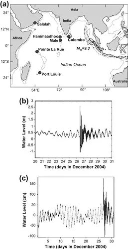 |
| Figure 1.1 (a) Map of the Indian Ocean showing the location of the Mw = 9.3 December 2004 earthquake (star), the aftershock zone (dotted area) together with positions of 6 selected sea-level stations. Source: Rabinovich et al., 2006; Reproduced with kind permission of Springer Science and Business Media; (b) Time-series of the sea-level record from Colombo, Sri Lanka, from 20 to 31 December, 2004 and (c) from Geraldton, Western Australia, for December, 2004 showing the scale of the tsunami with respect to the tidal range and also the presence of high-frequency oscillations subsequent to the tsunami. Source: Pattiaratchi and Wijeratne, 2009; Reproduced with kind permission of Springer Science and Business Media. |
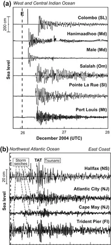
The powerful tsunami of 26 December 2004 was recorded all over the World Oceans, from Antarctica in the south to the far North Pacific and the North Atlantic Oceans, including most of the sites in Chile, Brazil, Peru, Mexico, California, British Columbia, Alaska, Hawaii, the Aleutian and the Kuril Islands. Figure 1.2 shows time-series of tsunami wave heights as recorded at selected sea-level stations in the three major ocean basins and some island locations. Exceptions are the stations located deeply inside straits and inlets, stations sheltered from open ocean waves (e.g., Seattle, Tacoma, Vancouver and Queen Charlotte City [See Figure 1.3]), and open coast stations that are strongly affected by wind waves and swell, and consequently having very low signal-to-noise ratio (Rabinovich, et al., 2006).
 |
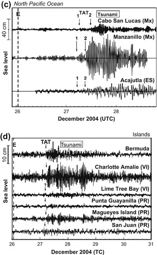 |
| Figure 1.2 Tsunami records for the 2004 Sumatra tsunami for selected sites in (a) Indian Ocean; (b) Northwest Atlantic Ocean; (c) North Pacific Ocean; and (d) some Island locations. Dashed vertical line labeled “E” denotes the time of the main earthquake shock. “TAT” is the tsunami arrival time; arrows and numbers denote arrivals of the first and second wave trains. Source: Rabinovich et al., 2006; Reproduced with kind permission of Springer Science and Business Media. |
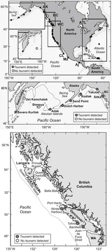 |
| Figure 1.3 Maps indicating several sites in the Pacific Ocean where December 2004 Indian Ocean tsunami were detected and a few sites where this tsunami was not detected. Source: Rabinovich et al., 2006; Reproduced with kind permission of Springer Science and Business Media. |
Historically, there have been several other tsunamis as well, which proved to be disastrous at different regions at varying levels at different occasions in the past; having killed tens of thousands of people and caused severe damage to the coastal areas of the world. As noted by Rabinovich et al., (2006), it is, perhaps, not a coincidence that the first known global tsunami event, i.e., the tsunami associated with the Krakatau Volcano eruption of August 27, 1883, and the third historically documented global tsunami event (i.e., December 2004 Sumatra tsunami) also occurred in the Indonesian Archipelago. The fact that both the 1883 and the 2004 global tsunami events originated in the same region demonstrates the potential of this region as a major source for worldwide catastrophic tsunamis. Although more than 75 percent of all tsunamis in the World Ocean have originated in the Pacific Ocean, two of the three most destructive global tsunamis have originated in the Indian Ocean. It is to be noted that the 2004 tsunami event has been followed by annual occurrence of oceanwide tsunamis (i.e., those which influence areas far from the generation region) in 2005 (earthquake magnitude 8.6 on 28 March), in 2006 (earthquake magnitude 7.7 on 17 July), and in 2007 (earthquake magnitude 8.5 and 7.9 on 12 September). The directions of tsunami wave propagation during these earthquake events were different, but oriented primarily towards the south/south-west direction (Figure 1.4). The extent of the 2005 and 2007 Sumatra tsunamis permeated as far as Sri Lanka (Pattiaratchi and Wijeratne, 2009) and even into the Arabian Sea.
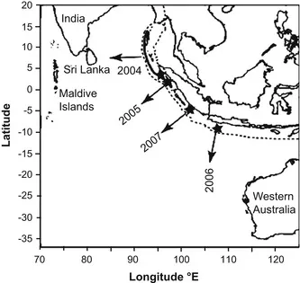 |
| Figure 1.4 Map of the eastern Indian Ocean showing the location of the earthquake epicenters (indicated by stars) and direction of the primary wave propagation for the 2004, 2005, 2006, and 2007 Indian Ocean tsunamis. Note that there were two earthquakes in September 2007 within 12 hours. The dashed line indicates the plate boundary; the thick black line indicates the area of rupture for the 2004 tsunami. Source: Pattiaratchi and Wijeratne, 2009; Reproduced with kind permission of Springer Science and Business Media. |
The September 2007 tsunami was recorded in the Lakshadweep archipelago in the Arabian Sea, and Goa on the west coast of India (Prabhudesai et al., 2008) although it was too weak to cause casualties. In recent years, the Indian Ocean continues to be haunted by earthquake-generated tsunamis, the latest being the August 10, 2009 earthquake at the Andaman Island in the Indian Ocean. The most recent in 2009 is the September 29, 2009 earthquake (magnitude 8.0) at the Samoa Islands region of the South Pacific Ocean. The Pacific Tsunami Warning and Mitigation System coordinated by UNESCO’s Intergovernmental Oceanographic Commission (IOC) issued a clear warning throughout the region 16 minutes after the earthquake. People who have been able to receive the warning messages evacuated to upper grounds and their lives were saved. The response was described as good, and many people seem to have learned the lessons from the 2004 Indian Ocean tsunami. However, in regions very close to the earthquake site, the short time available for warning and evacuation of coastal populations posed a major challenge to local authorities; with coastal residents in some areas not having received the requisite information in time.
Several sea-level gauges that were positioned all over the world recorded the tsunami waves caused by the Great Sumatra-Andaman Earthquake on December 26, 2004, revealing its truly global reach. Although no direct damage or destruction has been reported for this tsunami event outside the Indian Ocean, sea-level records available from different parts of the world demonstrate the ability of tsunami waves to penetrate all the world oceans (Merrifield et al., 2005; Titov et al., 2005; Woodworth et al., 2005). This tsunami is one of a small number known to have been observed around the world. It is also the first global-scale tsunami in the “instrumental era,” and was measured by an unprecedented number of tide gauges (sea-level gauges) throughout the world oceans. The total number of known records of this tsunami in the Indian, Atlantic, and Pacific Oceans is about 250, from which relatively high-quality worldwide sea-level measurements are available (Titov et al., 2005; Rabinovich, 2009). More than 50% of these records are for regions where tsunamis had never before been recorded (the Atlantic coasts of Africa and South America, the Antarctica coast, and a major part of the Indian Ocean) and were made by instruments that were not designed to measure tsunami waves. The 2004 tsunami also was recorded by a number of bottom pressure gauges that had been installed on the shelf and deep in the ocean within the framework of nontsunami projects, including those examining oceanic circulation, climatic change, ocean stratification and transport, and related ocean drilling studies. These observations have yielded valuable scientific information on the physics, dynamics, and energy characteristics of tsunami waves. In addition, such multifarious tsunami measurements collected by different types of instruments with different sampling intervals and deployed at sites strongly dissimilar in their local topographic and geographical properties are invaluable for specialists working on tsunami measurements and early tsunami warnings (Rabinovich, 2009).
The 2004 Sumatra tsunami is now recognized as the most globally distributed and accurately measured tsunami in recorded history. Tsunami amplitudes along many Indian Ocean coastlines were measured in meters and in some cases the waves were large enough to destroy the sea-level recording equipment (Merrifield et al., 2005). For example, the sea-level gauge at Colombo (Sri Lanka) was damaged by the first tsunami wave and did not operate for 3 hours and 30 minutes, coinciding with the arrival of the highest waves (Pattiaratchi and Wijeratne, 2009), and eyewitness reports had to be relied upon (Rabinovich and Thomson, 2007). Likewise, the sea-level gauge at Nagapattinam, located on the most strongly affected sector of the Indian coast, was heavily damaged by the tsunami waves so that the 2004 tsunami record could not be retrieved (Nagarajan et al., 2006).
Available records from the African continent suggest that the Sumatra tsunami showed its presence in African countries as well, although its intensity deteriorated significantly on the western coastline of this continent (Joseph et al., 2006; Rabinovich and Thomson, 2007). Amplitudes along the Atlantic coastlines, especially those of North and South America, were often tens of centimeters (Rabinovich, 2005). The Atlantic Ocean historically has had no tsunami warning systems (TWSs), and no standard instruments designed for tsunami measurements existed. Unlike the Pacific Ocean, the Atlantic Ocean is not bordered by major subduction zones, which are the main sources of large tsunamis (Lockridge et al., 2002; Gusiakov, 2006). So infrequent were tsunamis in the Atlantic that in the period immediately following the 2004 Sumatra tsunami, few experts had expected that this tsunami would be recorded outside the Indian Ocean. Nevertheless, a few days after the earthquake, tsunami waves were identified in several sea-level gauge records on the coast of North America. On the South American coast in the Atlantic, detection of the 2004 tsunami includes sites in Brazil (Candella, 2005; Melo and Rocha, 2005; Franca and de Mesquita, 2007) and Argentina (Dragani et al., 2006), which are regions where tsunamis had never been recorded previously. The 2004 tsunami was also detected in several records from the South and Central Atlantic, in particular at Signy (South Orkney Islands), Port Stanley (Falkland Islands...
Table of contents
- Cover Image
- Table of Contents
- Front Matter
- Copyright
- Preface
- Acknowledgments
- Chapter 1. Introduction
- Chapter 2. Tsunami Generation and Historical Aspects
- Chapter 3. Tsunami Databases
- Chapter 4. Geophysical Tsunami Hydrodynamics
- Chapter 5. Impact of a Tsunami on Coastal and Island Habitats
- Chapter 6. The Protective Role of Coastal Ecosystems
- Chapter 7. Earthquake Detection and Monitoring for Early Warnings of Seismogenic Tsunamis
- Chapter 8. Numerical Models for Forecasting
- Chapter 9. The Role of IOC-UNESCO in Tsunami Early Warnings
- Chapter 10. Earthquake Monitoring for Early Tsunami Warnings
- Chapter 11. Open Ocean Tsunami Detection
- Chapter 12. Land-Based Measurements of Inundation to Confirm Tsunamigenesis
- Chapter 13. The Technology of End-to-End Communication: Sending the Message
- Chapter 14. IOC-UNESCO Tsunami Early Warning Systems
- Chapter 15. Technological Challenges In Detecting Tsunamis
- Chapter 16. Sea-Level Measurements From Coasts and Islands
- Chapter 17. Sea Level Measurements From Deep-Sea Regions
- Chapter 18. Telemetry of Sea-Level Data
- Chapter 19. Evaluating and Assessing Tsunamis Technologies for Specific Situations
- Chapter 20. Extracting Tsunami Signals From Sea-Level Records
- Chapter 21. Conclusions
- References
- Bibliography
- Index
Frequently asked questions
Yes, you can cancel anytime from the Subscription tab in your account settings on the Perlego website. Your subscription will stay active until the end of your current billing period. Learn how to cancel your subscription
No, books cannot be downloaded as external files, such as PDFs, for use outside of Perlego. However, you can download books within the Perlego app for offline reading on mobile or tablet. Learn how to download books offline
Perlego offers two plans: Essential and Complete
- Essential is ideal for learners and professionals who enjoy exploring a wide range of subjects. Access the Essential Library with 800,000+ trusted titles and best-sellers across business, personal growth, and the humanities. Includes unlimited reading time and Standard Read Aloud voice.
- Complete: Perfect for advanced learners and researchers needing full, unrestricted access. Unlock 1.5M+ books across hundreds of subjects, including academic and specialized titles. The Complete Plan also includes advanced features like Premium Read Aloud and Research Assistant.
We are an online textbook subscription service, where you can get access to an entire online library for less than the price of a single book per month. With over 1.5 million books across 990+ topics, we’ve got you covered! Learn about our mission
Look out for the read-aloud symbol on your next book to see if you can listen to it. The read-aloud tool reads text aloud for you, highlighting the text as it is being read. You can pause it, speed it up and slow it down. Learn more about Read Aloud
Yes! You can use the Perlego app on both iOS and Android devices to read anytime, anywhere — even offline. Perfect for commutes or when you’re on the go.
Please note we cannot support devices running on iOS 13 and Android 7 or earlier. Learn more about using the app
Please note we cannot support devices running on iOS 13 and Android 7 or earlier. Learn more about using the app
Yes, you can access Tsunamis by Antony Joseph in PDF and/or ePUB format, as well as other popular books in Physical Sciences & Oceanography. We have over 1.5 million books available in our catalogue for you to explore.