- 246 pages
- English
- ePUB (mobile friendly)
- Available on iOS & Android
eBook - ePub
About this book
Synoptic Analysis and Forecasting: An Introductory Toolkit provides the bridge between the introductory fundamentals of a meteorology course and advanced synoptic-dynamic analysis for undergraduate students. It helps students to understand the principles of weather analysis, which will complement computer forecast models. This valuable reference also imparts qualitative weather analysis and forecasting tools and techniques to non-meteorologist end users, such as emergency/disaster managers, aviation experts, and environmental health and safety experts who need to have a foundational knowledge of weather forecasting.- Presents the fundamentals of weather analysis and forecasting- Offers clear accessible writing aimed at students from a variety of mathematical backgrounds- Discusses the reading and interpretation of surface observations and METAR code, processes associated with the motion and intensity of cyclones and anticyclones, and quantitative and/or qualitative diagnosis of processes associated with ascent and descent
Tools to learn more effectively

Saving Books

Keyword Search

Annotating Text

Listen to it instead
Information
1
Meteorological Conventions
Abstract
Meteorological observations and forecasts use a universal time system known as Universal Coordinated Time (UTC) or Zulu (Z). It is vital to be able to convert time in Z to whichever local time zone the observer or forecaster is working in. While most meteorological variables use the MKS unit system, there are some exceptions such as temperature, wind speed, and pressure. Temperatures are generally reported in degrees Celsius, with one major exception: surface temperatures in the United States, which use degrees Fahrenheit. Wind speeds are generally reported in knots, while atmospheric pressure most commonly is given in millibars, equivalent to the hectopascal. Finally, wind directions are reported in degrees as where the wind is coming from, using a coordinate system unique to meteorology.
Keywords
Meteorological conventions; Units of measure; Time zones; Zulu time; Temperature; Wind speed and direction; Atmospheric pressure
1.1 Time Zones and Zulu (Z) Time
Weather analysis and forecasting are global pursuits. The forecaster should not limit him or herself to learning only about their city, region, country, or continent. Because numerical weather prediction models and forecasts are produced across the globe, it is crucial that the meteorological enterprise operates largely independent of time zones. In fact, the word synoptic is derived from Greek, meaning “at the same time.”
Meteorological observations and forecasts use Universal Coordinated Time (UTC), otherwise known as Zulu (Z)1 or Greenwich Mean Time (GMT), which operates on a 24-h clock. This system was first devised in the United Kingdom and is based on the time at Greenwich, England, which is located on the Prime Meridian (0° longitude). In order to become familiar with typical meteorological analysis and forecast times, it is crucial to know how to convert from Z to your local time zone and vice versa.
The conversion from Z to your local time requires knowledge of how many time zones you are away from Greenwich, England, and what time of year it is (i.e., whether it is Daylight Saving Time). For example, 12Z is noon in Zulu time; at the same time, the US east coast is 7 a.m. local time in the winter (Eastern Standard Time) and 8 a.m. local time in the summer (Eastern Daylight Time). In California and British Columbia, 12Z is 4 a.m. Pacific Standard Time and 5 a.m. Pacific Daylight Time, respectively. Table 1.1 details the time conversion and local times for various locations across North America at key meteorological observation times.
Table 1.1
Examples of Time Conversions From Zulu (Z) Time for Specific Locations Across North America
| Time Zone | Cities Included | Hours Behind Z | 00Z | 12Z |
| Atlantic Standard Time (AST) | Halifax, Hamilton (Bermuda), San Juan (Puerto Rico) | 4 | 8 p.m. AST | 8 a.m. AST |
| Eastern Standard Time (EST) | New York City, Miami, Toronto | 5 | 7 p.m. EST | 7 a.m. EST |
| Central Standard Time (CST) | Chicago, Houston, Winnipeg | 6 | 6 p.m. CST | 6 a.m. CST |
| Mountain Standard Time (MST) | Denver, Albuquerque, Calgary | 7 | 5 p.m. MST | 5 a.m. MST |
| Pacific Standard Time (PST) | Los Angeles, Seattle, Vancouver | 8 | 4 p.m. PST | 4 a.m. PST |
| Alaska Standard Time (AKST) | Juneau, Anchorage, Nome | 9 | 3 p.m. AKST | 3 a.m. AKST |
| Hawaii Standard Time (HST) | Honolulu, Hilo, Pearl City | 10 | 2 p.m. HST | 2 a.m. HST |
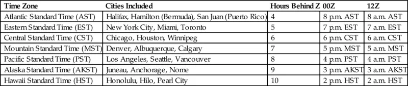
For Daylight Saving Time, one fewer hour should be subtracted from Z.
1.2 Common Units of Measurement
Most meteorological variables and calculations are handled using standard metric (SI) meters-kilograms-seconds (MKS) un...
Table of contents
- Cover image
- Title page
- Table of Contents
- Copyright
- Preface
- Acknowledgments
- 1: Meteorological Conventions
- 2: Surface Observations and Instrumentation
- 3: METAR Code
- 4: Upper-Air Observations
- 5: Isopleths and Upper-Tropospheric Charts
- 6: Lower-Tropospheric Charts
- 7: Upper-Tropospheric Processes
- 8: Lower-Tropospheric Processes
- 9: Putting It All Together
- 10: Fronts and Drylines
- 11: Satellite Imagery
- 12: Radar Imagery
- 13: Thermodynamic Diagram Basics
- 14: Thermodynamic Diagram Interpretation
- 15: Weather Forecasting Basics
- Index
Frequently asked questions
Yes, you can cancel anytime from the Subscription tab in your account settings on the Perlego website. Your subscription will stay active until the end of your current billing period. Learn how to cancel your subscription
No, books cannot be downloaded as external files, such as PDFs, for use outside of Perlego. However, you can download books within the Perlego app for offline reading on mobile or tablet. Learn how to download books offline
Perlego offers two plans: Essential and Complete
- Essential is ideal for learners and professionals who enjoy exploring a wide range of subjects. Access the Essential Library with 800,000+ trusted titles and best-sellers across business, personal growth, and the humanities. Includes unlimited reading time and Standard Read Aloud voice.
- Complete: Perfect for advanced learners and researchers needing full, unrestricted access. Unlock 1.4M+ books across hundreds of subjects, including academic and specialized titles. The Complete Plan also includes advanced features like Premium Read Aloud and Research Assistant.
We are an online textbook subscription service, where you can get access to an entire online library for less than the price of a single book per month. With over 1 million books across 990+ topics, we’ve got you covered! Learn about our mission
Look out for the read-aloud symbol on your next book to see if you can listen to it. The read-aloud tool reads text aloud for you, highlighting the text as it is being read. You can pause it, speed it up and slow it down. Learn more about Read Aloud
Yes! You can use the Perlego app on both iOS and Android devices to read anytime, anywhere — even offline. Perfect for commutes or when you’re on the go.
Please note we cannot support devices running on iOS 13 and Android 7 or earlier. Learn more about using the app
Please note we cannot support devices running on iOS 13 and Android 7 or earlier. Learn more about using the app
Yes, you can access Synoptic Analysis and Forecasting by Shawn Milrad in PDF and/or ePUB format, as well as other popular books in Biological Sciences & Environmental Science. We have over one million books available in our catalogue for you to explore.