Situated on Broadway between Fourteenth and Seventeenth Streets, Union Square occupies a central place in both the geography and the history of New York City. Though this compact space was originally designed in 1830 to beautify a residential neighborhood and boost property values, by the early days of the Civil War, New Yorkers had transformed Union Square into a gathering place for political debate and protest. As public use of the square changed, so, too, did its design. When Frederick Law Olmsted and Calvert Vaux redesigned the park in the late nineteenth century, they sought to enhance its potential as a space for the orderly expression of public sentiment. A few decades later, anarchists and Communist activists, including Emma Goldman, turned Union Square into a regular gathering place where they would advocate for radical change. In response, a series of city administrations and business groups sought to quash this unruly form of dissidence by remaking the square into a new kind of patriotic space. As Joanna Merwood-Salisbury shows us in Design for the Crowd, the history of Union Square illustrates ongoing debates over the proper organization of urban space—and competing images of the public that uses it.
In this sweeping history of an iconic urban square, Merwood-Salisbury gives us a review of American political activism, philosophies of urban design, and the many ways in which a seemingly stable landmark can change through public engagement and design.
Published with the support of Furthermore: a program of the J. M. Kaplan Fund.
Trusted by 375,005 students
Access to over 1 million titles for a fair monthly price.
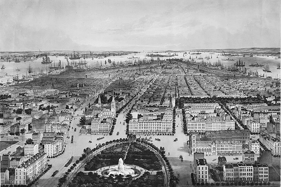
In 1849 John Bachmann created a picture of the entire city of New York, an aerial view looking south from Union Square to Washington Square and the port beyond. Bachmann was a Swiss-born printmaker who had completed several bird’s eye views of American cities in the mid-nineteenth century, views all the more difficult to produce because they were drawn from the imagination: there was as yet no technology in place to raise the illustrator so high.1 This is the earliest known of his works. As reflected in his mind’s eye, Union Square was an urban set piece, the northern terminus of the city and the antithesis of the commercial area around Wall Street and City Hall. This was the home of the “the upper ten thousand,” or just “the upper ten”—the elite of New York society, whose members were characterized not by their noble birth but by their possession of money, taste, and good manners.2 As the astute English visitor Isabella Bird noted a few years later, while in England the word “society” was used to denote the aristocracy and those who moved in their circle, “New York has its charmed circles also; a republic admits of the greatest exclusiveness.”3 Two squares, Washington and Union, were the physical manifestation of that exclusiveness, a spatial realization of the greatly uneven benefits that capitalist speculation had brought to the city. Unsurprisingly, those who lived there did not see their enclave as a sign of social or economic inequity: to them the squares and the magnificent homes surrounding them were evidence of the supremacy of republican capitalism, under which social and economic advancement was open to all comers. In the mid-nineteenth-century mind-set, the increasingly ostentatious homes built there were ornaments to the city in much the same way the squares were. On display to all who wished to see them, they beautified the city as a whole, providing evidence of its prosperity and an incentive to entrepreneurial newcomers.4
1.1 “New-York.” Print by John Bachmann, 1849.
The completion of Union Square in 1839 marked the segregation of New York City into two distinct territories. No longer clustered around the site of the colonial settlement at the southern end of Manhattan, the city had grown, its path directed by the ambitious grid plan laid out in 1811. “Downtown,” the area around the docks and Wall Street, was the center of the city’s business, manufacturing, and political life. Two miles further north, the fashionable “Uptown” district comprised a series of then recently built residential enclaves anchored by landscaped squares. Union Square, where Broadway terminated at Fourteenth Street, was the heart of Uptown. Elliptical in shape, the Square appears antithetical to the 1811 grid plan, whose designers emphatically rejected the inclusion of, “circles, ovals or stars”—typical of public spaces designed after the European model—in favor of a homogenous and orthogonal grid designed to communicate the republican ideal of equality. The creation of Union Square was part of a larger project to improve New York City, a task that encompassed a broad range of activities including planning, drainage, road building, and the construction of transportation systems and a clean water supply, all of which accompanied the rapid growth of the city in the early decades of the nineteenth century. These improvements were grounded in a doctrine of progress that supported the ideals held by the early city planners. Created in the second quarter of the nineteenth century, Washington, Tompkins, Union, Stuyvesant, and Madison Squares were considered “ornaments” to the city, aesthetic counterparts to less visible infrastructural improvements that were transforming the thriving commercial metropolis.
Samuel Bulkley Ruggles, the impresario behind the creation of Union Square, was a practitioner of urban improvement. A lawyer and property speculator, he leased property rather than buying it outright, amassing a large parcel of land holdings between Fourteenth and Twenty-Third Streets, a parcel whose value he sought to increase via the construction of public works. While chiefly remembered as the creator of Gramercy Park, a private square, Ruggles was also a commissioner of the Eerie Canal Company and of the Croton Aqueduct, linked activities that restructured the city and the regional landscape surrounding it. In this way he helped flesh out the cartographic bones laid down by the Commissioners’ Plan of 1811, creating elegant public and private parks within it, and linking it productively to its larger geographic terrain. Beginning in the late 1820s he argued for the improvement of the uneven and unkempt parcel of land known as Union Place, one of the few areas designated for public use in the original city plan. Ruggles’s efforts to improve Union Place, and the conflicting ways in which his contemporaries viewed those efforts, illustrate the transformation of ideas about the function and value of public space in New York City between the early and mid-nineteenth century.
Private and Public Space in the New York City Grid
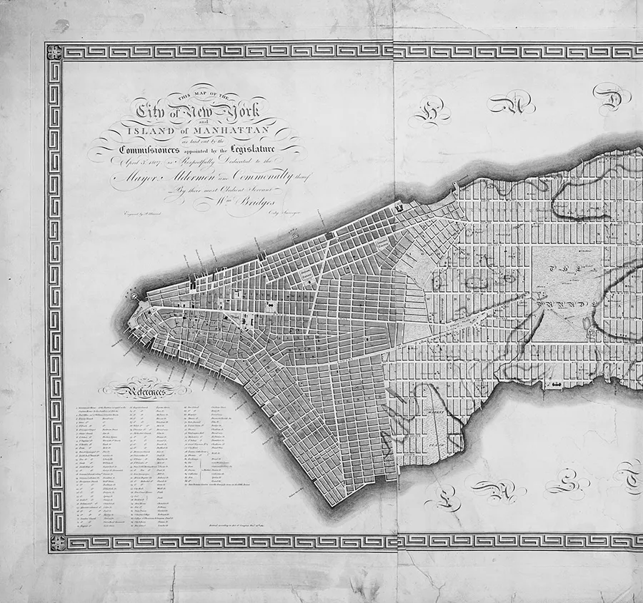
Union Place was a product of the expansion of New York City during the prosperous second and third decades of the nineteenth century. Following the end of the War of 1812, which eased trade with Europe, and the completion of the Erie Canal in 1825, which opened up trade with the newly created western states, the city experienced an economic boom, one that financed dramatic growth in business and plentiful new construction.5 Already a commercial metropolis, New York soon usurped Boston and Philadelphia as the center of global trade on the North American continent. As the population grew and capital accumulated, New Yorkers were anxious to invest their profits in their enlarging city and to improve its appearance befitting its new status. Beyond the colonial-era settlement at the southern end of Manhattan, the rocky and wild island was largely rural, sparsely populated with small farms, country estates, and a few villages such as Harlem to the north. Barely noticeable on the surface of the fields and dirt roads, however, lay a signifier of things to come: a network of survey markers, iron bolts inserted into the ground. These markers were laid out under the direction of a surveyor named John Randel Jr.6 In 1807 the New York State legislature had appointed a commission to “regulate” the city’s streets and to accommodate its growth.7 The state-appointed “Commissioners of Streets and Roads”—Simeon De Witt, Gouverneur Morris, and John Rutherford—had no doubt that the city would continue to flourish, projecting a fourfold increase in population to four hundred thousand people by the middle of the century. In 1811 they unveiled a plan to cater to this increase, dividing the island of Manhattan north of Houston Street into an enormous matrix of twelve north-south avenues and 155 east-west streets. Once completed, the grid plan would create 2,028 rectangular parcels of land, irrespective of existing geography or settlements. Randel was the surveyor employed to translate the abstract grid into reality. In his hands, Manhattan was about to become a “theater of progress.”8
1.2 Southern section of the Commissioner’s Plan for New York City, 1811.
The plan that Randel worked for years to implement was one of a series of projects to regulate and improve American towns and cities beginning in the late eighteenth century. Influenced by high-minded if not utopian Enlightenment ideals, they were intended to guide the creation and growth of settlements on the new continent in the most efficient way possible, ensuring those settlements were both socially and economically profitable.9 Characterized by the subjugation of the environment to human use, they involved the aggressive leveling of natural topography and the application of a rigid urbanizing geometry. As the architectural historian Dell Upton has noted, in the early years of the American republic the simple grid plan with its evenly spaced streets and equally sized city blocks was a popular regulating device, both because it was easy to implement and understand and also because of its egalitarian symbolism. Though it dated back to ancient times, the grid could be seen as the spatial expression of republicanism, a political philosophy that had at its core
a notion of political sovereignty vested in the people as a whole, understood as a collection of free individuals who were in some fundamental way essentially the same, therefore comparable, whatever their contingent differences in status or condition. Order in such a body politic arose from within, from the character of its citizens, rather than being imposed by a higher authority.10
In these terms the homogeneity and regularity of the grid plan was a reflection of the democratic ideal: like all citizens, all plots of land were equivalent, and none was valued above another. While Upton credits the gridded towns common to early American city planning with utopian aspirations, other scholars have described them as the outcome of pragmatic thinking rather than applied political philosophy. More specifically, they are sometimes regarded as the spatial embodiment of capitalism, a system under which the process of urbanization is driven solely by the need to ensure the efficient flow of wealth.11 This interpretation, in which the chief virtue of the grid is that it divides the land available for development into parcels that are easy to measure and trade, is supported by contemporary accounts. The surveyor Randel praised the 1811 plan for Manhattan as an effective mechanism for, “buying, selling, and improving real estate.”12 In these terms it has come to be seen, fairly or not, as a monument to the primacy of real estate speculation, one in which property values outweighed considerations such as the beauty of republican simplicity.13 There is no doubt that the philosophical and economic justifications underlying the grid plan were inextricably linked: capitalism was the economic and de facto governing system of the new republic. By creating thousands of nearly identical small lots, the Commissioners’ Plan greatly increased the amount of land available for sale and settlement and, as a result, greatly augmented the number of land owning (and thus voting) citizens. Over time the expansion of the city was accompanied by the expansion of its polity.
This system of urban organization had a particular and lasting effect on the relationship between private and public space. As the geographer Don Mitchell has noted, emphasizing the interests of private property owners had important consequences for the development of the public realm: “The public sphere of American (and other capitalist) democracies is . . . understood as a voluntary community of private (and usually propertied) citizens.”14 In other words, private landowners acting collectively created public space and determined how it would be used. This was especially true of early nineteenth-century New York City where the municipal government played a relatively small role and attended to a limited range of planning activities. In this context, any public benefit resulting from urban improvements was largely the work of private individuals.
Samuel Ruggles and the Improvement of Union Place
This is the milieu in which Samuel Ruggles began his real estate ventures in the 1820s. While speculative investors were buying up and filling out the grid, few dedicated public spaces existed within it and even fewer were created. Ruggles held no official position when he began his work in what we would today call urban planning. Instead he acted through his connections with the Whig elite who controlled the city government. Born in 1801 to a comfortably well-off Hudson Valley family, he had studied at Yale before establishing a law practice in New York City in 1822.15 Although a newcomer to New York society, he joined its highest ranks by marrying Mary Rosalie Rathbone, the daughter of a wealthy merchant, John Rathbone. Rathbone began his career in the salt trade, establishing his business, John Rathbone and Co. (later John Rathbone and Son), near the East River docks at Front Street in 1804. Rathbone and his son, John Jr., were so successful that they were regarded as “almost the head of the mercantile body of our greatest commercial city.”16 The family gained considerable political influence when John Jr., Ruggles’s brother-in-law, was elected a member of the state legislature in 1823. Before long Ruggles was advising his in-laws and their friends on property management. Soon he began to invest in property on his own accord, using some of his wife’s money and a modest inheritance from his father. By the 1830s he was a wealthy man, one of the founders of the Bank of Commerce, with his success enabling him to attain political office: in 1838 he was elected to the New York State Assembly.
While he was only one of many entrepreneurs hoping to benefit from the city’s rapid expansion, Ruggles was one of an elite group with the determination and connections to make significant alterations to the fabric of New York City. In this he was particularly well equipped because of his prodigious energy and his skills as a publicist. Until 1830 all decisions about public works were made by the twenty members of the Common Council, the governing body of the city elected by propertied citizens. With the grid plan laid out, this council had little inclination to plan any major urban design initiatives. Instead they responded to the lobbying of an ad hoc “public” made up of propertied citizens who occasionally came together to determine what they saw as a common need. Municipal records from this time consist largely of petitions to the council from private citizens, including requests for the development of particular streets and (in fewer cases) public squares, as well as incidental projects such as the erection of statues. Many of these petitions began with public meetings organized by the urban elite where property owners discussed their own needs and desires, which, they believed, were broadly commensurate with the general public good.
At this time the sparsely populated area north of Fourteenth Street, designated the Twelfth Ward, was undergoing something of a real estate gold rush, and the abstract lines of the 1811 street grid were beginning to assume a physical reality.17 Enterprising businessmen were buying and leasing land in the area, realizing that the encroachment of commercial premises further and further north along Broadway was making it a desirable investment, despite its current isolation. Ruggles focused his attention on lots between Nineteenth and Twenty-Fourth Streets, the Bloomingdale Road (now Broadway), and Second Avenue. Still rural, the real estate holdings he acquired were part of an old landholding known as the “Gramercy Farm.” Because the terrain was irregular, differentiated by hills and swamps, Ruggles began the work of having his properties graded, and in the process he established a contracting business that did similar work for the city.
In the 1830s the social center of New York lay a mile to the south near what is now Cooper Square, around Lafayette Place and Fourth Avenue. Befitting his status as an ambitious and well-connected lawyer, Ruggles lived there, at 36 Bond Street. His neighbors were members of New York’s political, social, and business elite, including, as a street manual described it, “the mayor of the city; the town’s most popular physician; the pastor of one the largest and wealthiest churches; a Senator of the United States; one of the city’s two representatives in Congress; an ex-secretary of the treasury; a major general in the army who became one of our most distinguished soldiers and a candidate for the presiden...
Table of contents
Cover
Title Page
Copyright Page
Contents
List of Illustrations
Acknowledgments
Introduction
1 An Ornament to the City, 1811–1850
2 The Altar of Patriotism, 1856–1865
3 Olmsted and Vaux’s Plaza, 1865–1872
4 The People’s Forum, 1872–1886
5 The Home of Discontent, 1886–1917
6 City Beautiful Civic Center, 1898–1933
7 Cold War Park, 1934–1965
8 Renewal, Revitalization, and Place Making, 1966–1998
Conclusion
Notes
Index
Frequently asked questions
Yes, you can cancel anytime from the Subscription tab in your account settings on the Perlego website. Your subscription will stay active until the end of your current billing period. Learn how to cancel your subscription
No, books cannot be downloaded as external files, such as PDFs, for use outside of Perlego. However, you can download books within the Perlego app for offline reading on mobile or tablet. Learn how to download books offline
Perlego offers two plans: Essential and Complete
Essential is ideal for learners and professionals who enjoy exploring a wide range of subjects. Access the Essential Library with 800,000+ trusted titles and best-sellers across business, personal growth, and the humanities. Includes unlimited reading time and Standard Read Aloud voice.
Complete: Perfect for advanced learners and researchers needing full, unrestricted access. Unlock 1.4M+ books across hundreds of subjects, including academic and specialized titles. The Complete Plan also includes advanced features like Premium Read Aloud and Research Assistant.
Both plans are available with monthly, semester, or annual billing cycles.
We are an online textbook subscription service, where you can get access to an entire online library for less than the price of a single book per month. With over 1 million books across 990+ topics, we’ve got you covered! Learn about our mission
Look out for the read-aloud symbol on your next book to see if you can listen to it. The read-aloud tool reads text aloud for you, highlighting the text as it is being read. You can pause it, speed it up and slow it down. Learn more about Read Aloud
Yes! You can use the Perlego app on both iOS and Android devices to read anytime, anywhere — even offline. Perfect for commutes or when you’re on the go. Please note we cannot support devices running on iOS 13 and Android 7 or earlier. Learn more about using the app
Yes, you can access Design for the Crowd by Joanna Merwood-Salisbury in PDF and/or ePUB format, as well as other popular books in History & Urban Planning & Landscaping. We have over one million books available in our catalogue for you to explore.