Activating Urban Waterfronts shows how urban waterfronts can be designed, managed and used in ways that can make them more inclusive, lively and sustainable. The book draws on detailed examination of a diversity of waterfronts from cities across Europe, Australia and Asia, illustrating the challenges of connecting these waterfront precincts to the surrounding city and examining how well they actually provide connection to water. The book challenges conventional large scale, long-term approaches to waterfront redevelopment, presenting a broad re-thinking of the formats and processes through which urban redevelopment can happen. It examines a range of actions that transform and activate urban spaces, including informal appropriations, temporary interventions, co-design, creative programming of uses, and adaptive redevelopment of waterfronts over time. It will be of interest to anyone involved in the development and management of waterfront precincts, including entrepreneurs, the creative industries, community organizations, and, most importantly, ordinary users.
eBook - ePub
Activating Urban Waterfronts
Planning and Design for Inclusive, Engaging and Adaptable Public Spaces
- 250 pages
- English
- ePUB (mobile friendly)
- Available on iOS & Android
eBook - ePub
Activating Urban Waterfronts
Planning and Design for Inclusive, Engaging and Adaptable Public Spaces
About this book
Trusted by 375,005 students
Access to over 1.5 million titles for a fair monthly price.
Study more efficiently using our study tools.
Information
Topic
ArchitectureSubtopic
Sustainability in ArchitecturePart I
Plugging the Waterfront into the City
Chapter 1
Three ‘Southbanks'
During the last few decades, the waterfront areas of many ‘post-industrial’ cities in North America, Britain, Europe, Australia and elsewhere have undergone a remarkable transformation. Emerging from industrial degradation and from burial under transportation infrastructure, inner-urban harbours and riverfronts have been reborn as showpiece cultural and leisure precincts (Pinder et.al. 1988; Meyer 1999). This waterfront redevelopment has gone hand-in-hand with a broader renaissance of inner cities after decades of suburban dispersion. Urban waterfronts have become key drawcards for foreign tourists, visitors from the suburbs, and new upmarket residents. They are locus for a variety of cultural institutions, ranging from elitist (concert halls and art galleries) to populist (casinos, movie theatres and aquariums). They provide extensive new areas of high-quality public open space in precisely those parts of the city where land values are highest and social life at its most dense. In their elongated form, they also establish new linkages between existing inner-city areas, intensifying the interconnectedness of urban functions. They have dramatically increased the activity in inner cities during evenings and weekends. The opening up of the urban riverfront has brought about an extensive re-orientation of the entire city, both spatially and behaviourally.
A Common History of Waterfront Regeneration
In London, Melbourne and Brisbane, three former industrial waterfront areas which were all redeveloped into leisure precincts called ‘Southbank’ each lie on the opposite side of the river to their cities' central activities districts. These Southbanks have historically been relatively poorly connected by transport infrastructure to their north riverbanks. A brief historical introduction reveals the similarities of planning approaches and design in the three cases, as well as differences in the opportunities framed by each context (Figure 1.1).
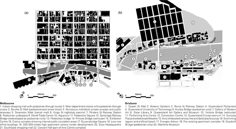
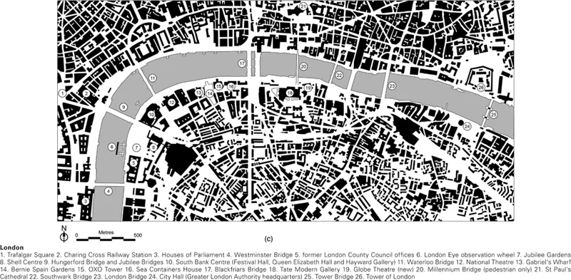
Figure 1.1Maps of Southbanks in Melbourne (a), Brisbane (b) and London (c) to the same scale, showing their connections to their respective central city areas on the opposite riverbanks.
Source: Quentin Stevens and Ha Thai
In London, the Thames River only had its one original crossing point until the Westminster Bridge opened in 1750. The south riverbank, opposite the City, has always been very low-lying, and it was only in the 1860s with the construction of the Albert Embankment that the land here was stabilised and new landfill extended into the width of the river. This neighbourhood, Southwark, had, like many medieval suburbs outside cities' walls, long been a place of noxious industries and ‘low’ entertainment such as bull rings, bear pits, wrestling and brothels. A theatre district, including the famous Globe Theatre, developed here in the 1580s and ’90s to serve the rapid growth of Elizabethan London, burgeoning when seditious theatre was barred from the City (Hall 1998). By the 1800s, an increasing number of bridges and the rapidly increasing number and size of ships and cargoes led to London's port moving downriver, and the South Bank's many warehouses fell into decline (Ball and Sutherland 2001). The 1943 London Plan formally designated the area a cultural precinct. After extensive wartime bombing, many remaining warehouses were demolished for the 1951 Festival of Britain, a large temporary exposition. The remaining Festival Hall was joined in the 1960s by the Brutalist, inward-facing Hayward Gallery and Queen Elizabeth Hall, and numerous new, insular Modernist office buildings monopolised the riverfront (Simões Aelbrecht 2017). The Globe Theatre was rebuilt in 1996 by private investors. The revival in both government and private investment in British cities through the ‘Urban Renaissance’ agenda of Tony Blair's New Labour (1997–2010) drove extensive re-investment in the Southwark waterfront, including a major refurbishment of the cultural venues in the Southbank Centre, the new Tate Modern art gallery (2000) in the renovated Bankside Power Station, and two new pedestrian bridges in 2002. The Millennium Bridge linked the Tate Modern to St. Paul's Cathedral. Two broad new Jubilee bridges were suspended alongside the Hungerford Bridge that carried trains into Charing Cross Station, replacing very cramped older footbridges.
The Southbank of Melbourne's Yarra River also has a long history of use for leisure functions such as temporary fun parks. In 1964, the state government built a major public art gallery on the south side of the main Princes Bridge which linked the city to its southern suburbs. Beginning in 1982, a new government acquired 100 hectares of land stretching more than 1km along the water's edge and produced a long-term planning framework. The art gallery was expanded into an Arts Centre with a concert hall and theatres by 1984. A museum was planned for the other, western end of the precinct to provide a second anchor for a new 15m-wide publicly-accessible riverfront promenade. The first private investment was a set of medium-rise office buildings on the suburban office-park model. A new pedestrian bridge which linked across to the precinct opened in 1989, followed in 1992 by SouthGate, a shopping, dining and hotel complex backed by two office towers. These two developments started to realise and expand the leisure potential of the area.
Another new government after 1992 brought deregulation of the planning function and more commercially-driven investments on the waterfront from both private and public sectors. The Esso corporate headquarters filled the remaining site in the eastern part of the Southbank in 1995. The partially-built museum to the west was converted and completed in 1996 as the largest exhibition centre in the Asia-Pacific region. The 500m of remaining frontage between the two precincts was filled in 1997 by the Crown Casino, a single 500,000m2 building on an eight hectare site, encompassing gaming tables, cinemas, nightclubs, restaurants, shops and a 43-storey hotel tower. A new public square was constructed in the middle of the length of Southbank, as were several apartment towers set back behind the river frontage, the tallest being 200m and 300m high (Sandercock and Dovey 2002; Dovey 2005).
Brisbane's South Bank had previously been the site of the city's wharves, cold storage, fish market, and interstate rail freight terminal. The area contained numerous cheap hotels and boarding houses, as well as live theatres, cinemas, dance halls and nightclubs which made it the city's entertainment quarter. With the wharves falling into disuse during the 1960s, the State Government of Queensland first began large-scale redevelopment of the area in 1977 with plans for a multi-venue Cultural Centre at the south end of the Victoria Bridge connection to the Central Business District (CBD), and the reclamation of 1.9 hectares of the river. The first stage, the Queensland Art Gallery, was completed in 1982, with the Queensland Museum, State Library and Performing Arts Centre all finished by the mid-1980s. These brutalist buildings are all by the same architect, Robin Gibson, and are linked by elevated pedestrian concourses. A small privately-run maritime museum had opened on a disused wharf approximately 1.5km south along the riverfront in 1979 (Longhurst 1992; Fagence 1995; Mullins et.al. 1999).
In 1983 Brisbane was awarded the right to host the 1988 World Expo, the year of Australia's bicentennial celebrations, and legislation was passed to acquire a 500m-wide strip of derelict riverfront between the Cultural Centre and the Maritime Museum to use as the Expo site. These 16 hectares were raised above the 100-year floodplain (Craik 1992; Fagence 1995; Mules 1998). After Expo, a 1989 Act of Parliament created a public corporation for redevelopment of the site as public parklands, plus 27 hectares of surrounding land for a mixture of commercial and residential uses. An approved development plan was gazetted in 1990, and a new public riverfront park, which incorporated a rainforest and an artificial beach at the edge of a freshwater swimming ‘lagoon’, was opened in 1992. Apartments, a convention and exhibition centre and associated hotels were completed during the mid 1990s (Queensland Government 1990; Mules 1998; Mullins et.al. 1999). A new pedestrian bridge connecting the south end of the South Bank precinct to the CBD was opened in 2001 at a cost of AUD $35 million (Wanna 2001). The Queensland Gallery of Modern Art, at the north end of the Cultural Centre, was opened late 2006, and another pedestrian bridge was designed to connect this end of South Bank to the CBD and to redevelopment of the north bank opposite (Department of Public Works 2005). The South Bank Parklands currently attract more than 5 million visitors each year (Mullins et. al. 1999).
These three case studies follow a typical pattern where decades of disinvestment and the undesirable image of remaining land uses had lowered waterfront property values, creating opportunities for government intervention, large-scale recapitalisation and speculative gain. Yet this success was only possible because of a much broader shift in value: people became newly attracted to the city centre and to the water's edge. The question of what makes inner-urban waterfronts special, valuable sites for public leisure is the focus of this chapter. Answers focus on the potential which such sites provide for a range of experience and leisure behaviour.
Gordon (1996) suggests a number of key stratagems for the successful planning and design of urban waterfronts (see Table 1.1). The last four of the five issues Gordon presents all speak to a concern with the creation of an inclusive social leisure environment, a place where different people and activities can come together and mix. The first three of the listed issues highlight the strong emphasis on visual quality and legibility, which is a product of the high visibility of waterfront sites, their commonly degraded appearance, and the wider ‘thematisation’ of urban leisure environments (Sorkin 1992; Loukaitou-Sideris and Banerjee 1998). These two larger themes – leisure space as urban diversity and leisure space as image – form the focus of the current analysis.
|
Source: Gordon (1996), drawing on Eckstut (1986).
Gordon highlights the importance for all investors in waterfronts of having design guidelines which ensure high quality. However, questions remain as to what can actually provide the measure for design quality. This chapter attempts to provide a framework for considering quality in urban waterfront redevelopment which is both informed by a robust theory of leisure behaviour and linked to the study of the actual everyday function, sensory experience and use of waterfront spaces. The chapter seeks to identify how the pursuit of the design objectives listed above give shape to the scope of people's leisure behaviour ‘on the ground’ in urban waterfront precincts.
Dodson and Kilian (1998) move the critique of waterfronts beyond their simplistic depiction as spectacularised theme parks (Harvey 1989; Sorkin 1992) to examine the proposition that urban waterfronts are in fact contested ‘sites of control and resistance’, where consumers (sic) are actively involved in the ongoing production of the meaning of place, bringing with them different identities, values, perceptions and practices (Dodson and Kilian 1998, 156). They find that visitors are drawn to the urban waterfront chiefly because of the diversity of other people and experiences on offer, and they critique the frequent use of design, marketing and management to achieve racial and class exclusivity. They note some users' resistance to the consumption orientation of the waterfront, through such activities as protest marches which are ‘antithetical to the purposes of the designers' (Dodson and Kilian 1998, 160). Unfortunately, Dodson and Kilian's own data is limited to a visitor survey conducted by the Cape Town waterfront's managers and newspaper reports, and provides few specifics about environment-behaviour relations.
Relatively little research on waterfront leisure precincts has involved going down to these sites and observing how various groups of people actually use them, particularly during the times when there are no scheduled events to stimulate activity, and trying to understand how design characteristics of the waterfront leisure landscape shape and support perceptions ...
Table of contents
- Cover
- Half Title
- Title
- Copyright
- Contents
- List of Contributors
- Acknowledgements
- Introduction
- Part I Plugging the Waterfront into the City
- Part II Switching the Waterfront On
- Conclusion
- Bibliography
- Index
Frequently asked questions
Yes, you can cancel anytime from the Subscription tab in your account settings on the Perlego website. Your subscription will stay active until the end of your current billing period. Learn how to cancel your subscription
No, books cannot be downloaded as external files, such as PDFs, for use outside of Perlego. However, you can download books within the Perlego app for offline reading on mobile or tablet. Learn how to download books offline
Perlego offers two plans: Essential and Complete
- Essential is ideal for learners and professionals who enjoy exploring a wide range of subjects. Access the Essential Library with 800,000+ trusted titles and best-sellers across business, personal growth, and the humanities. Includes unlimited reading time and Standard Read Aloud voice.
- Complete: Perfect for advanced learners and researchers needing full, unrestricted access. Unlock 1.5M+ books across hundreds of subjects, including academic and specialized titles. The Complete Plan also includes advanced features like Premium Read Aloud and Research Assistant.
We are an online textbook subscription service, where you can get access to an entire online library for less than the price of a single book per month. With over 1.5 million books across 990+ topics, we’ve got you covered! Learn about our mission
Look out for the read-aloud symbol on your next book to see if you can listen to it. The read-aloud tool reads text aloud for you, highlighting the text as it is being read. You can pause it, speed it up and slow it down. Learn more about Read Aloud
Yes! You can use the Perlego app on both iOS and Android devices to read anytime, anywhere — even offline. Perfect for commutes or when you’re on the go.
Please note we cannot support devices running on iOS 13 and Android 7 or earlier. Learn more about using the app
Please note we cannot support devices running on iOS 13 and Android 7 or earlier. Learn more about using the app
Yes, you can access Activating Urban Waterfronts by Quentin Stevens in PDF and/or ePUB format, as well as other popular books in Architecture & Sustainability in Architecture. We have over 1.5 million books available in our catalogue for you to explore.