![]()
CHAPTER – 1
INTRODUCTION
Geography is the study of the surface of the earth, its physical features, location, size and shape, natural resources and climate. It influences the development of the people who reside there and teaches them to cope with different types of terrain like the deserts, mountains, plains and isolated islands. Cultural geography comprises human interaction which includes the intermingling of economics, migration, language, religion and culture. In geopolitics, these very elements of geography influence the strategic thinking of a nation and play a vital role in defining and shaping peace and security in the region. Therefore the national power, national interests and national strategic thinking could also be attributed to geographic factors.1
The theory that geography affects a state’s strategic culture means that it is inherently linked to politics. Clausewitz suggests that “war is nothing but the continuation of political efforts by other means” and thus “the plan for the war results directly from the political conditions of the two belligerent states, as well as from their relations to other powers.” Clausewitz propounded the idea of geopolitical strategy but it was not until Halford J. Mackinder in his article titled “The Geographical Pivot of History” that geography began to grow in importance in influencing a state’s strategic culture.2 Mackinder’s most powerful ‘Heartland’ theory was basically a struggle between the land based and sea based powers. He saw that with no new places to conquer, the sea and land based powers would fight for world dominance and the victor would setup a world empire.3 Mackinder advocated that maritime powers have always benefitted due to their geographic advantage accrued because the sea front provided them with greater strategic security allowing them to trade on a far larger scale as compared to land powers.
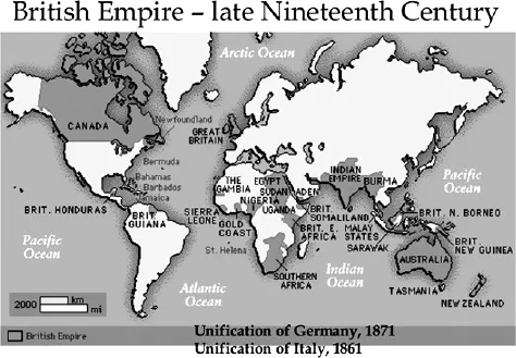
The British Empire of the eighteenth and nineteenth centuries is an excellent illustration of a state exploiting their natural geographic strengths to develop a power base capable of projecting their force on a global scale as well as be the centre for world trade. In essence British political, military and economic strategies were reflections of Britain’s island geography.4 The British method of war was to land relatively small bodies of troops at chosen points, to get a strategic result. Victory was assured by the control of the seas.
Source: http://www.slideshare.net/gchee99/lecture-7a-world-war-i
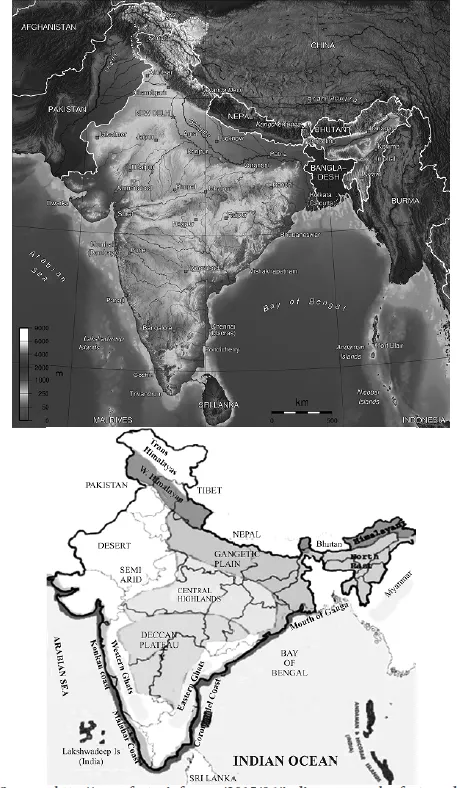
A look at the geographical entity of India indicates its unique character. India is the seventh largest country in the world with a land area of 3.2 million sq km. Its territorial borders were settled by adjudication but later have been forged through conflict and are still contested. India’s land boundaries total 15,106.7 km. India shares common borders with Pakistan (3,323 km; the Jammu and Kashmir border is 1,085 km), China (Line of Actual Control is 3,488 km), Bhutan (699 km), Nepal (1,751 km), Myanmar (1,643 km), and Bangladesh (4,096.7 km). Although India and Sri Lanka do not share a land boundary, the narrowest distance between the two countries is only 64 km across the Palk Strait. Most of Jammu and Kashmir is contested with Pakistan, and the Aksai Chin area of Jammu and Kashmir is disputed with China, as is the border of Arunachal Pradesh in northeast India.5 Nepal claims a 75 sq km area called Kalapani6. The 40 year old maritime dispute between India and Bangladesh related to New Moore Island (South Talpatty) in the Bay of Bengal has been resolved by the UN Tribunal recently. Similarly the decades old pending border demarcation with Bangladesh has also been resolved in 2015. India shares maritime borders with five countries.
Source – http://www.factsninfo.com/2015/06/indian-geography-facts-and-information.html
The total coastline is 7,516 km in length, comprising 5,422 km for the mainland, 132 km for the Lakshadweep Islands, and 1,962 km for the Andaman and Nicobar Islands. The Indian peninsula juts 1,980 km into the Indian Ocean. Fifty percent of the Indian Ocean basin lies within a 1,500 km radius of India, a reality that has strategic implications. Under the 1982 United Nations Convention on the Law of the Sea, India has a 200 nautical mile Exclusive Economic Zone (EEZ), a 12 nautical mile territorial sea, a 24 nautical mile contiguous zone, and a legal continental shelf extending to a depth of 2,500 metres or to the end of the continental margin. India has 1,197 islands in the Indian Ocean. (572 in the Andaman and Nicobar – 37 of which are inhabited – and 23 in the Lakshadweep – 10 of which are inhabited. In addition, there are 447 islands off the western coast and 151 islands off the eastern coast.7
Source: http://iasmania.com/physiographic-divisions-of-india/
Since independence, India has been searching to attain a strategic identity and thereafter to articulate stable strategic thought. India’s strategic thinking is deeply affected by its geography, history, culture and the British rule for about 200 years. The enormous size of the country with its linguistic, religious, cultural and ethnic diversity at times appears to be in contrast to its internal bickering over attainment of political power and strife on the one hand and national interests on the other. Geography has had a profound effect on the thinking of Indian leaders, making them believe that its greatness lies in its geo-strategic location, size and large population. It gives rise to the thought that India can play a pre-eminent role in the region. The Himalayan range and Hindukush Mountains in the north have always acted as a physical barrier both climatically as well as to keep out external intruders. Whereas, the seas surrounding peninsular India give the natural protection from maritime invasion as also bestow the innate advantage of sitting astride the shipping lanes between Europe, Middle East and Australia, South East, Japan. Besides these advantages, the vast network of rivers make North India a fertile location from where invaders from Aryan civilisations have made forays for centuries being attracted to the Indian riches and thus building large kingdoms. Hence for centuries these invasions from land have brought in different cultures and traditions that have interlaced with our original psyche and merged into a comprehensive society. Therefore, since most of these invaders came over the land, our overall mindset has assumed a continental orientation over the oceans.8
South India was relatively insulated from these attackers. Infact, their outlook was more oriented towards the oceans as they indulged in trade with the Arabs and Europeans and thus had retained their Dravidian languages and culture. Parts of the Coromandel and Malabar coasts have a very rich maritime heritage and thus were more agriculture and trade oriented.
Gurcharan Das in his article in “Times of India” 14 Jun 2015 brings out amply that India possessed a rich maritime culture with bustling trade with the Romans in the Muziris port of Kerala nearly 2000 years back. He goes on to narrate that this trade continued till the seventeenth century with the Portuguese and the British. India was a great trading nation at times accounting for 20 percent of world trade in those times. However, he claims that India’s power has always been ‘soft’ not expressed through military conquests but only export of goods and ideas. Indian culture travelled mostly through trade during the fourth and the twelfth centuries which saw a major decline after the British occupation.9
The northern orientation and mindset has led to an overall land oriented outlook. Even today Pakistan in the northwest occupies most of our attention followed by China in the north and north east. Whereas, southern India is more maritime in its outlook and chooses to look seaward in its strategic approach. Thus this difference in orientation could be seen as both, unifying as well as dividing India in its strategic attitude. The very same natural obstacles in the north that are perceived by India to keep external invaders at bay have become mental boundaries within whose confines lies our strategic vision.
India of Mauryan Empire was known for its statecraft with the legendary Chanakya writing volumes on establishing correlation between exercise of soft and hard power and the Chola Empire extended upto present day South East Asia. In the subsequent period, India saw most of foreign incursions mainly from the north with none being defeated totally. This led to India always fighting on the defensive in its own terrain with no forward or offensive strategy of curbing such invaders. Besides, as various states were fragmented, there was no unity amongst them to provide comprehensive security cover for the combined region. All these are pointers that there was not much stress given to strategic thought since long. There was no vision on maritime outlook except for a few states in South India. Infact, the total failure of the Moghuls to perceive a threat from the seas when the Europeans landed unopposed indicates lack of vision by the Moghuls and in turn the Indians. However, subsequently the Indian trade by sea prospered but the goods were still transported mainly in foreign bottoms. Thus history has played a major role in our neglect of the seas.10
Soon after WW-II, India gained independence in 1947. Thereafter, the Indian Army was immediately occupied with the Pakistan incursions in Kashmir and the Royal Indian Navy which was a very small force had to start a new genre of thought on redefining its maritime strategy. The strategic environment changed in the late 1950s with a belligerent Pakistan in the West and a communist led China to the North/ Northeast; our preoccupation to handle these two countries limited our vision to develop a proactive national maritime strategy with a global outlook and led to “Sea Blindness” – which essentially portrays insensitivity to the role the oceans and consequently the islands in nation building. Thus the inability of the Government and by extension the population in general of understanding the maritime domain, not only from just the military point of view, but also from a wider economic and technological perspective has led to the neglect of our strategic security and economic prosperity. Even though India has a rich maritime heritage, the recurring attacks through the Asian landmass on our territorial integrity and poorly demarcated borders have blinded our approach towards discharging our responsibilities as a nation with a god-gifted maritime advantage.
George K. Tanham has also enunciated that the deeply embedded habits of thoughts related to Indian geography, history, culture and belief systems exert a powerful influence on perceptions of military power and national security which have shaped its strategic thinking and culture.11 Indian focal point therefore remains the neighbouring states as there are a host of security problems and dilemmas that confront the strategic thinkers. A strategic culture with a broad maritime outlook has not been allowed to settle due to repeated skirmishes over land. There is a reluctance to explore the potential of the maritime dimension of the strategically located Andaman and Nicobar Islands as the lessons of the past seem to have percolated the sub-conscious, thus making them disregard maritime affairs.
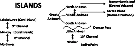
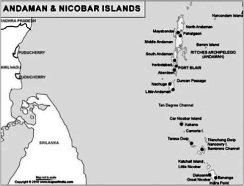
Andaman & Nicobar Islands is a Union Territory of India and is located over 1200 km east of the Indian mainland. The topography of the Andaman and Nicobar Islands has a typical character with the presence of 572 islands and islets, spread over a length of 720 Km in a broken chain which form geologically a part of the land mass of South East Asia including, North East India, Myanmar, Malaysia, Thailand and Indonesia. Only 37 of these islands are inhabited. This island chain can be classified into two groups of islands with the North Andaman, Middle Andaman, South Andaman and Little Andaman forming the Andaman group, and Great Nicobar, Car Nicobar, Nancowry, Katchal and Chowra forming the Nicobar group. This archipelago of 572 islands covers an area of 8249 square kilometres.12
Source: http://www.indiaprofile.com/india-maps/andaman-nicobar-map.html
Located on the trade routes from India to East Asia, the Andaman and Nicobar islands have been known from earliest times and have historically been inhabited by tribal population. The 7th century Chinese Buddhist monk I-ching, the Arab travellers of the 9thcentury, and Marco Polo (c. 1254 – 1324) are among those who mentioned the islands. The name Andaman most likely is derived from the name of Lord Hanuman from Hindu mythology. The name Nicobar probably derives from the Tamil word nakkavaram (land of the naked).13 Occupation by the Chola dynasty during 1014 -1042, its use as a maritime base for Maratha ships in the 17thcentury, establishment of a base in these islands by Admiral Kanhoji Angre to achieve naval supremacy in the region and its annexation by the British and occupation by the Japanese during the WW II to progress their strategic interests – indicates the appreciation of its strategic significance since time immemorial.
The modern history of these islands begins with the British rule in 1788, when Lord Cornwallis, the governor-general of India, sent Lieutenant Archibald Blair and Lieutenant R. H. Colebrook to find the suitability of the islands for housing the British Colony. On their recommendation, the first settlements were established on Chattam Island, a small island near Port Cornwallis. But after the famous, so called ‘Sepoy Mutiny’ in 1857, the British founded a penal settlement in Andaman and Nicobar Islands with an intension to accommodate criminals, especially the ever increasing number of rebels charged with disloyalty towards the British regime. Initially, nearly 200 prisoners were housed on Viper Island. Construction of the jail at Port Blair commenced in November 1887 using the...