- 352 pages
- English
- ePUB (mobile friendly)
- Available on iOS & Android
eBook - ePub
Geographic Objects with Indeterminate Boundaries
About this book
Current geographical information systems GIS deal almost exclusively with well-defined, static geographical objects ranging from physical landscapes to towns and transport systems. Such objects, exactly located in space, can easily be handled by modern GIS, yet form only a small proportion of all the possible geographical objects.; This book challenges the assumption that the world is compsed of exactly defined and bounded geographic objects such as land parcels, rivers and countries. ignoring the essential complexity of the world, current GIS do not adequately address problems as diverse as the resolution of crime between national boundaries, or the interpretation of views of people from different cultures. This work, bringing together a range of specialists from fields such as linguistics, computer science, land surveying, cartography and soil science, examines current research into the challenges of dealing with geographical phenomena that cannot easily be forced into one of the two current standard data models.
Tools to learn more effectively

Saving Books

Keyword Search

Annotating Text

Listen to it instead
Information
Topic
Physical SciencesSubtopic
Civil EngineeringPART ONE
Introductions by the Editors
CHAPTER ONE
Natural Objects with Indeterminate Boundaries
Department of Physical Geography, University of Utrecht, The Netherlands
To think is to forget a difference, to generalize, to abstract. In the overly replete world of Funes there was nothing but details, almost contiguous details.
Jorge Luis Borges, Funes the Memorious (1962)
The aim of this introduction is to provide a backdrop for subsequent chapters, particularly those in Parts 5 and 6. It reviews the basic concepts of ‘objects’ and ‘fields’ used for modelling geographic objects and their handling using conventional discrete logic and explains how these conventional approaches are insufficient for working with complex, polythetic natural phenomena. The basic principles of geostatistics for dealing with quantitative variation in fields are explained. The main ideas of fuzzy set theory and fuzzy k-means classification are introduced and illustrated by applications that (a) demonstrate the decrisping of idealized polygon boundaries, and (b) the extraction of crisp boundaries as zones of confusion between interpolated, polythetic, overlapping classes.
1.1 Simple data models: Objects and fields
In order to model natural phenomena in terms that people can understand it has always been necessary to abstract and to generalize. Because most natural phenomena are complex, varying at many scales in space and time, geographers, soil scientists, geologists, hydrologists, climatologists and other environmental scientists have been forced to select the most important aspects of any given phenomenon and to use these as the basis for information storage and transfer.
Generalizing and abstracting complex, multiscale phenomena requires serious thought: it is far from easy. The ‘best’ generalization for one purpose may be unsuitable for another. Ideally, each discipline and each scientist would derive a separate generalization for every different situation as the need arises but in practice, and certainly in times before computers and remote sensing, that was simply not possible. To reduce the natural environment to terms that could be easily understood, where information could be stored and exchanged readily, required agreements and standardization. These led to a plethora of classification systems, mapping conventions and jargon that sometimes served their purpose, and sometimes failed as efficient carriers of information. The testing of classification and map quality in soil science, for example, became a major research activity in the years between 1965 and 1985 as scientists increasingly discovered that the classification and mapping systems they had established did not always provide a sound basis for information transfer (cf. Beckett and Webster, 1971; Burrough, 1993). Raper and Livingstone (1995) argue convincingly that the failure to appreciate the interactions between three-dimensional spatial and temporal extents of environmental objects and the nature of physical processes that mould them has resulted in serious philosophical and practical problems when attempting to link environmental models with GIS.
1.1.1 Geographic data models in space and time
Until recently, two diametrically opposed geographic data models were available for encapsulating the important aspects of physical phenomena as perceived by the natural environmental scientist: these are the exact object model and the continuous field model. Ideal geographic entities have crisply defined spatial boundaries and a well defined set of attributes. A typical example is the land parcel in which the boundaries have been accurately surveyed and the attributes of area, ownership, actual use, permitted use, tax value, and so on, apply uniformly to the whole object. On the other hand, there are geographical phenomena that are more often thought of as continuous fields - air pressure, elevation as represented by the hypsometric surface, hydraulic heads or pollution plumes. These are usually represented by smooth mathematical surfaces (often polynomial functions) that vary continuously and smoothly over space-time.
In the conventional exact object model of geographical phenomena, natural entities are represented by crisply delineated ‘points’, lines’, ‘areas’ (and in three dimensions) ‘volumes’ in a defined and absolute reference system. Lines link a series of exactly known coordinates (points), areas are bounded by exactly defined lines (which are called ‘boundaries’) and volumes are bounded by smooth surfaces. Lines are linked by a defined topology to form networks which, if open, can represent rivers or blood veins, or if closed, the abstract or defined boundaries of polygons that in turn represent land parcels, soil units or administrative areas. The properties of the space at the points, along the lines or within the polygons or volumes are described by attributes, whose values are assumed to be constant over the total extent of the object. This is the choropleth (areas of equal value) model. Cartographic convention has reinforced these abstractions by insisting that mapped boundaries should only be represented by lines of a given style and thickness.
In the simplest form of the continuous field model there are no boundaries. Instead, each attribute is assumed to vary continuously and smoothly over space: its variation can be described efficiently by a smooth mathematical function and it can be visualized by lines of equal value (isopleths, or contours). In practice, these fields are often discretized to a regular grid at a given level of resolution.
Both the conventional object model and the continuous field model (Figure 1.1) are two extreme abstractions of reality that are attractive for their logical consistency and their ease of handling using conventional reasoning and mathematics.
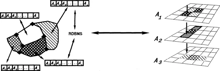
Figure 1.1 Examples of simple spatial objects and fields. Left: a simple object structure with topology and attributes for each polygon. Right: Simple continuous fields (discretized) with a separate layer for each attribute.
Both are easily implemented in computerized information systems. The object model in its simplest form has been implemented using a relational database structure for the attributes and a network data structure for the topology: the continuous field can be handled in a purely relational database structure once it has been discretized to a regular grid. Alternatively, it can be approximated by a network database structure such as a TIN (triangular irregular network) if discretized by a Delauney triangulation (Burrough, 1986). In the TIN the attribute values at data points at the apices of the triangle represent the variation of the elevation field, but each triangle carries a constant value of the local second derivatives of the field, namely, the slope and aspect. Both object and field models have become so accepted as fundamental aspects of geographic information systems that few persons question their general validity.
Both models have been implemented using the graphic models of vector and raster structures. The vector structure enhances even further the abstraction to exact objects because in the computer digitized lines are by definition infinitely thin (Figure 1.2, left), while the raster structure introduces approximations in shapes and form because of discretization on a regular grid (Figure 1.2, right). Directed pointers between objects can easily be handled in vector system but network interactions can only be handled in raster system by considering cell-to-cell neighbour interactions.
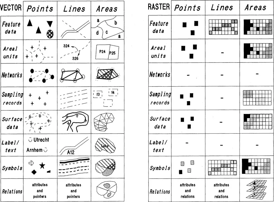
Figure 1.2 Conventional representation of objects and fields in vector and raster GIS.
In the sciences that map natural phenomena - surveying, geology, soil science, geomorphology, vegetation, land use, climate, hydrology, etc. - general agreements have developed over the years about when either one of the two data models should be used. In general, when the phenomenon being studied is interpreted as a predominantly static, qualitative complex entity which can be mapped on external features of the landscape then the object model is used (e.g. soil series, land systems, lithologic units, ecotopes). When single quantitative attributes are measured and mapped then the continuous field model is used (e.g. isohyets for rainfall, isobars for atmosphere, contour lines for elevation, etc.).
Note that in the conventional descriptions of phenomena, entities and fields are seen as frozen in time; the possible change in form or composition as a result of a physical process is usually ignored. At best, time is also discretized in steps, by displaying entities and patterns at different ...
Table of contents
- Cover
- Half Title
- Series Page
- Title Page
- Copyright Page
- Contents
- Series Editors’ Preface
- Editors’ Preface
- Contributors
- European Science Foundation
- Part One Introductions by the Editors
- Part Two Objects versus Fields: Contrast in Concepts
- Part Three Languages to Describe Shape
- Part Four Qualitative Topological Relations and Indeterminate Boundaries
- Part Five Data Models for Indeterminate Objects and Fields
- Part Six Practical Issues of Dealing with Objects with Indeterminate Boundaries
- Part Seven Postscript
- Index
Frequently asked questions
Yes, you can cancel anytime from the Subscription tab in your account settings on the Perlego website. Your subscription will stay active until the end of your current billing period. Learn how to cancel your subscription
No, books cannot be downloaded as external files, such as PDFs, for use outside of Perlego. However, you can download books within the Perlego app for offline reading on mobile or tablet. Learn how to download books offline
Perlego offers two plans: Essential and Complete
- Essential is ideal for learners and professionals who enjoy exploring a wide range of subjects. Access the Essential Library with 800,000+ trusted titles and best-sellers across business, personal growth, and the humanities. Includes unlimited reading time and Standard Read Aloud voice.
- Complete: Perfect for advanced learners and researchers needing full, unrestricted access. Unlock 1.4M+ books across hundreds of subjects, including academic and specialized titles. The Complete Plan also includes advanced features like Premium Read Aloud and Research Assistant.
We are an online textbook subscription service, where you can get access to an entire online library for less than the price of a single book per month. With over 1 million books across 990+ topics, we’ve got you covered! Learn about our mission
Look out for the read-aloud symbol on your next book to see if you can listen to it. The read-aloud tool reads text aloud for you, highlighting the text as it is being read. You can pause it, speed it up and slow it down. Learn more about Read Aloud
Yes! You can use the Perlego app on both iOS and Android devices to read anytime, anywhere — even offline. Perfect for commutes or when you’re on the go.
Please note we cannot support devices running on iOS 13 and Android 7 or earlier. Learn more about using the app
Please note we cannot support devices running on iOS 13 and Android 7 or earlier. Learn more about using the app
Yes, you can access Geographic Objects with Indeterminate Boundaries by Peter A. Burrough,A. Frank in PDF and/or ePUB format, as well as other popular books in Physical Sciences & Civil Engineering. We have over one million books available in our catalogue for you to explore.