The topic of inquiry is a political, military, and economic history of ancient Macedon during the reign of Philip II (359–336) in the fourth century BC. The first two chapters analyze the early history of Macedon and the development of the political, military, social, and economic institutions of the Macedonian kingdom. The balance of the book discusses the rise of Macedon from a small kingdom on the periphery of the Greek world to become the master of ancient Hellas and the Balkan world south of the Danube River.The central figure of the book is Philip II who ascended the throne as a young man in his early twenties after the defeat and death of his brother and six thousand Macedonians by the hostile Illyrians. The book follows his twenty-three-year reign as he guides the Macedonian people to the pinnacle of power and dominance over their neighbors in the Balkan world. You will witness the political, military, and economic growth of the kingdom that Philip created through his numerous reforms and conquests. His energetic, cunning, and inspired leadership will be revealed in these accomplishments. At Philip's death in 336, the foundation of power was established that his son Alexander the Great would use to conquer the Persian Empire.As Philip's power grew, you will encounter his seven wives that formed the basis of his diplomatic arrangements to protect the kingdom. You will be introduced to the leading characters whether family, friend, or foe. These include his wife and son Olympias and Alexander; friends Antipater and Parmenio; and foes Bardylis, Onomarchus, Demosthenes, and Artaxerxes III.The book concludes with an analysis of the assassination of Philip and Alexander's consolidation of power in the Balkan world in 335 BC before he embarks on his legendary journey.
- 322 pages
- English
- ePUB (mobile friendly)
- Available on iOS & Android
eBook - ePub
About this book
Trusted by 375,005 students
Access to over 1.5 million titles for a fair monthly price.
Study more efficiently using our study tools.
Information
Chapter One
Who Were the Macedonians?
Geography
Before we can tell the story of Philip II and Macedonia, we must answer one question. Who is a Macedonian? Geography, climate, language, religion, political, and social behaviors are the basic criteria to define a Macedonian.
The geography and climate of Macedonia determined the settlement pattern of the early inhabitants. Unfortunately, the borders of ancient Macedonia varied through the centuries. The ancient geographers had difficulty in determining these borders.1 However, they all agreed that Macedonia and Hellas (Greece) were separate entities. The familiar kingdom of Philip II and Alexander the Great did not appear until the 350s BC.
Map 4—Northern Greece and Macedonia
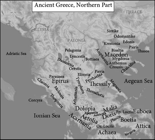
Map 4—Northern Hellas and Macedonia
(https://commons.wikimedia.org/wiki/Atlas_of_the_Macedonian Empire)
Author: MaryroseB54
The political kingdom known as Macedon was comprised of two regions known as Upper and Lower Macedonia.2 It was located north of Mt. Olympus, which separated Macedonia from Hellas. Lower Macedonia occupied the fertile plain along the northern coastline of the Thermaic Gulf. In the classical period, its inhabitants primarily lived on the land or in cities identified as poleis by Greek writers. However, unlike the Greek polis (city-state), these cities were not independent. Although self-governing in local affairs, they were subject to the rule of the king at Aegae. He conducted foreign policy and could interfere in local affairs when he deemed it necessary. Whether the kingdom was strong or weak, Lower Macedonia remained subordinate to the king. Although a few inhabitants engaged in trade and industry, the great majority were occupied in agriculture and pastoralism. Lower Macedonia was bordered to the east by the Chalcidic peninsula and the Thermaic Gulf. Its southern border ends at the Pierian Mountains, which separates Macedonia from the Greeks in Perrhaebia and Thessaly.
To the north and west, separated by hills, lies Upper Macedonia. Except for its eastern border on the Strymon River, Upper Macedonia is ringed by mountain ranges that separate it from Greece, Paeonia, Epirus, and Illyria. Only a handful of passes allow access from Upper Macedonia to its neighbors.3 The Haliacmon corridor, following the Haliacmon River through Orestis, Elimea, and Tymphaea, provides a major entrance route from Upper Macedonia into central Hellas. Most inhabitants were either farmers in the valleys or pastoralists, moving their herds of goats or sheep between the valleys and the mountains contingent on the season and food supply. There were small towns or villages but no large urban centers that could be defined as a city or polis in the Greek definition.4
The climate of Upper Macedonia is more continental than the Mediterranean climate of the Greek peninsula. This means that the weather pattern was generally cooler and wetter, especially in the mountain regions. Although summers could be hot, the winters were colder. Rather than wet and dry seasons (May to September) common to the Mediterranean moisture pattern, the average monthly rainfall was more evenly dispersed throughout the year. As a result, this rainfall pattern was more conducive to the yield of agriculture, support of animal herds, and the growth of the hardwood forests (oak, beech, fir, and pine) that prospered in Upper Macedonia.5
Upper Macedonia comprised the cantons of Tymphaea, Elimea (Elimiotis), Orestis, Eordaea, Lyncus (Lyncestis), and Derriopus. These cantons had their own independent ruling houses. Their political origins are unknown but may have derived from early tribal organizations. The rulers of Lyncus claimed that they were descended from the Bacchiadae of Corinth in the seventh century (Strabo.7.C326).6 Lower Macedonia comprised the areas of Bottiaea (Emathia), Eordaea, and Almopia and were inhabited by ethnic Macedones (Thuc.2.99).7 The fertility of the Macedonian plain derives from the silt deposits of the Haliacmon, Axios (modern Vardar), Loudias, and Echedorus (modern Gallikos) Rivers as they flow into the Thermaic Gulf.
Lower Macedonia was controlled by the Temenid king at Aegae, the initial capital of Macedon. Under strong kings, such as Alexander I (498–454) and Philip II (359–336), some of these Upper Macedonian districts became either subjects or allies of Lower Macedonia. Consequently, Macedonia became a player in the Hellenic political world. Under weak kings, the royal houses of Upper Macedonia ignored the Temenid king and ruled their cantons as independent kings (Thuc.2.99). Not until the fourth century did the cantons of Elimea and Lyncus become fully integrated into the Macedonian kingdom. Unfortunately, when the Macedonian kingdom was weak, these upper cantons were often exposed to depredations from their neighbors in Paeonia, Illyria, Epirus, and Thrace. Likewise, the inhabitants of Lower Macedonia were subject to the power politics of the southern Hellenic poleis. It was not until the reign of Philip II that Upper and Lower Macedonia were firmly united into one kingdom.
Although not generally associated with Macedonia proper, an interesting concept defined by Borza is the region he defines as Eastern Macedonia.8 This area comprises the lands east of the Axios River to the area east of the Strymon River, which includes the mines around Mt. Pangaeum.9 The borders of this region with Thrace were always in a state of flux during the classical period. From Alexander I until the final incorporation under Philip II, this region was constantly fought over between the Greeks, Macedonians, and Thracians. The inhabitants of the region included Macedonians, Thracians, Greeks, and a mixture of other groups. This region remained a core part of Macedonia throughout the Hellenistic period.
Ethnic Origins
The earliest habitation of the Balkans and Greece is dated between fifty thousand and thirty thousand years ago when Neanderthals roamed the region.10 Through the millennia, multiple migrations occurred. The origins of these ethnic groups, including Greeks and Macedonians, are not completely understood. The areas of Pelagonia and Lyncus in Upper Macedonia were settled in the Late Neolithic Age (c. 4000–2800 BC). By the middle Bronze Age (c. 1900 BC), the Indo-Europeans began to appear. Although they may have brought the earliest ...
Table of contents
- Chapter One
- Chapter Two
- Chapter Three
- Chapter Four
- Chapter Five
- Chapter Six
- Chapter Seven
- Chapter Eight
- Chapter Nine
Frequently asked questions
Yes, you can cancel anytime from the Subscription tab in your account settings on the Perlego website. Your subscription will stay active until the end of your current billing period. Learn how to cancel your subscription
No, books cannot be downloaded as external files, such as PDFs, for use outside of Perlego. However, you can download books within the Perlego app for offline reading on mobile or tablet. Learn how to download books offline
Perlego offers two plans: Essential and Complete
- Essential is ideal for learners and professionals who enjoy exploring a wide range of subjects. Access the Essential Library with 800,000+ trusted titles and best-sellers across business, personal growth, and the humanities. Includes unlimited reading time and Standard Read Aloud voice.
- Complete: Perfect for advanced learners and researchers needing full, unrestricted access. Unlock 1.5M+ books across hundreds of subjects, including academic and specialized titles. The Complete Plan also includes advanced features like Premium Read Aloud and Research Assistant.
We are an online textbook subscription service, where you can get access to an entire online library for less than the price of a single book per month. With over 1.5 million books across 990+ topics, we’ve got you covered! Learn about our mission
Look out for the read-aloud symbol on your next book to see if you can listen to it. The read-aloud tool reads text aloud for you, highlighting the text as it is being read. You can pause it, speed it up and slow it down. Learn more about Read Aloud
Yes! You can use the Perlego app on both iOS and Android devices to read anytime, anywhere — even offline. Perfect for commutes or when you’re on the go.
Please note we cannot support devices running on iOS 13 and Android 7 or earlier. Learn more about using the app
Please note we cannot support devices running on iOS 13 and Android 7 or earlier. Learn more about using the app
Yes, you can access Philip II of Macedon by Mark Luttenberger in PDF and/or ePUB format, as well as other popular books in History & Historical Biographies. We have over 1.5 million books available in our catalogue for you to explore.