The Geology, Ecology, and Human History of the San Luis Valley explores the rich landscapes and diverse social histories of the San Luis Valley, an impressive mountain valley spanning over 9,000 square miles that crosses the border of south-central Colorado and north-central New Mexico and includes many cultural traditions. Twenty-six expert scholars and educators—including geologists, geographers, biologists, ecologists, linguists, historians, sociologists, and consultants—uncover the natural and cultural history of the region, which serves as home to the Sangre de Cristo Mountains, the San Juan Mountains, Great Sand Dunes National Park and Preserve, and the Rio Grande headwaters.
The first section, "The Geology and Ecology of the San Luis Valley," surveys the geomorphology, hydrology, animal and plant life, conservation, management, and mining of the valley's varied terrain. The second section, "Human History of the San Luis Valley," recounts the valley's human visitation and settlement, from early indigenous life to Spanish exploration to Hispanic and Japanese settlements. This section introduces readers to the region's wide range of religious identities—Catholic, Latter-day Saint, Buddhist, Jehovah's Witness, Amish, and Mennonite—and diverse linguistic traditions, including Spanish, English, Dutch, Danish, Japanese, and Mayan. The final section, "Travel Itineraries," addresses recreation, specifically fly-fishing and rock climbing.
The book provides a comprehensive overview of the endemic flora and fauna, human history of indigenous lifeways, and diverse settlement patterns that have shaped the region. The Geology, Ecology, and Human History of the San Luis Valley will appeal to students and scholars of geology, ecology, environmental history, and cultural history, as well as residents and tourists seeking to know more about this fascinating and integral part of Colorado and New Mexico.
Contributors:
Benjamin Armstrong, Timothy Armstrong, Deacon Aspinwall, Robert Benson, Lorrie Crawford, Kristy Duran, Jeff Elison, Eric Harmon, Devin Jenkins, Bradley G. Johnson, Robert M. Kirkham, Bessie Konishi, Angie Krall, Richard D. Loosbrock, Richard Madole, A. W. Magee, Victoria Martinez, James McCalpin, Mark Mitchell, R. Nathan Pipitone, Andrew Valdez, Rio de la Vista, Damián Vergara Wilson
eBook - ePub
Geology, Ecology, and Human History of the San Luis Valley
- English
- ePUB (mobile friendly)
- Available on iOS & Android
eBook - ePub
Geology, Ecology, and Human History of the San Luis Valley
About this book
Trusted by 375,005 students
Access to over 1.5 million titles for a fair monthly price.
Study more efficiently using our study tools.
Information
Publisher
University Press of ColoradoYear
2020Print ISBN
9781646420414
9781646420391
eBook ISBN
9781646420407
Part I
Geology and Ecology of the San Luis Valley
Chapter 1
Geologic History of the San Luis Valley
Robert M. Kirkham and A. W. Magee
The complex geologic history of the San Luis Valley (SLV or the Valley) has intrigued geologists for well over a century. This chapter summarizes the many publications produced by these geologists. Three “recent” geologic events are chiefly responsible for the spectacular modern landscape of the Valley. The eastern San Juan Mountains are a large erosional remnant of the middle Tertiary Southern Rocky Mountain Volcanic Field, whereas the flat valley floor and the Sangre de Cristo Mountains that rise abruptly up from it owe their origin to the still active, late Cenozoic Río Grande rift. Pleistocene glaciation and related processes sculpted the mountains and deposited sediment. The Great Sand Dunes resulted from the combined effects of rifting, glaciation, and wind. Although the rift-related Sangre de Cristo Mountains are a younger physiographic feature than the eastern San Juan Mountains, most rocks exposed in the Sangres are hundreds of millions of years older than those in the San Juans.
The SLV also had a fascinating geologic history prior to the Southern Rocky Mountain Volcanic Field. For example, much of the Valley floor was formerly a mountain range, not just once but twice. During the late Paleozoic, the towering Uncompahgre–San Luis Uplift rose up where the flat Valley floor is today; where the Sangre de Cristo Mountains now stand high above the Valley floor, there was a deep structural trough that accumulated thousands of meters of sediment shed from the uplift. During the Late Cretaceous–early Tertiary Laramide Orogeny a second ancient mountain range, the San Luis Uplift, occupied much of today’s Valley floor. Deep structural basins existed west of the Laramide uplift: the Monte Vista Basin was between Alamosa and Del Norte, and the San Juan Sag, now concealed beneath a thick pile of volcanic rocks in the eastern San Juan Mountains, was farther west.
Geographic and Physiographic Setting
The SLV is a large, high-altitude, intermontane valley within the Southern Rocky Mountains that stretches across south-central Colorado and north-central New Mexico. The SLV includes the broad, elongate, low-relief Valley floor and parts of two majestic mountain ranges that drain into the Valley. Plate 1 shows the extent of the Valley and its major geographic and physiographic features.
The Valley encompasses the headwaters of the Río Grande and extends from the drainage divide in the San Juan and Tusas Mountains on the west to the crest of the Sangre de Cristo Mountains on the east. The northern end of the Sangre de Cristo Mountains and southern end of the Sawatch Range bound the northern end of the Valley, while the Valley’s southern end is near Pilar, New Mexico. Based on these limits, the SLV extends across nearly 25,000 km2 (9,650 miles2).
The Conejos and Red Rivers are major tributaries of the Río Grande. Surface water in most other streams and creeks in the northern part of the Valley, including San Luis Creek, either infiltrates into the ground, is diverted for irrigation, or flows into closed basins before reaching the Río Grande—helping to recharge both unconfined and confined aquifers below the Valley floor (Harmon, this volume).
The gradually rising San Juan Mountains on the west side of the Valley are known as the Eastern San Juans. A subset of the Eastern San Juans is the La Garita Mountains, which extend from near Creede toward Saguache. The section of the Eastern San Juans between US Highway 160 and the state line is also known as the South San Juans. Continuing south into New Mexico are the Tusas Mountains.
The narrow Sangre de Cristo Mountains rise abruptly above the eastern Valley floor. Within the SLV, the Sangres are subdivided into three ranges. The Northern Sangre de Cristo Range extends from Poncha Pass southward to the Blanca Massif, which includes four “fourteeners,” peaks with an altitude of 14,000 feet (4,268 m) or more. Another group of fourteeners is found within the Northern Sangres above the town of Crestone.
At Blanca Massif the range bends sharply and trends east-northeast for ~22 km (~14 miles). At La Veta Pass the range returns to its southerly trend and continues to just beyond the state line, forming the Culebra Range. A single fourteener exists in the Culebra Range; it is the highest privately owned peak in the United States.
Near the state line the Sangres swing southwestward. The Taos Range starts there and extends south beyond Taos. It includes the highest peak in New Mexico. Both the Northern Sangres and the Taos Range rise abruptly from the Valley floor, whereas a wide section of relatively low-lying foothills borders the west side of the Culebra Range. A relatively low-altitude, west-trending spur called the Picurís Mountains splits off the south end of the Taos Range.
Upson (1939) subdivided the Valley into several physiographic areas, defined in part by the San Luis Hills that rise up between Alamosa and the state line. The large, broad, relatively flat region north of the San Luis Hills is the Alamosa Basin. Much of Alamosa Basin north of the Río Grande is an internally drained, closed, topographic basin.
Culebra Reentrant is the area where the Culebra Range is recessed eastward relative to the Northern Sangre de Cristo Range and the Taos Range. Between the Culebra Reentrant and San Luis Hills is the Costilla Plains. The Taos Plateau occupies much of the southern part of the SLV. Many young volcanoes rise above the Taos Plateau, including San Antonio Mountain and Ute Mountain. The deep, narrow Río Grande Gorge was cut by the Río Grande as it eroded through the Taos Plateau.
Geologic History
Figure 1.1 is a geologic time chart annotated with the SLV’s major geologic events. Geologic formations found in the Valley are listed in the stratigraphic chart in figure 1.2. Plate 2 is a simplified geologic map showing where formations, or groups of formations, crop out in the Valley. Only major faults that are still active are depicted on plate 2. They include the Sangre de Cristo fault zone, Embudo fault, Valley View fault zone, and Mesita fault.
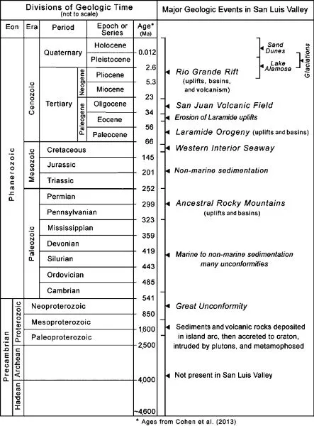
Figure 1.1. Geologic time chart, annotated with major geologic events in San Luis Valley.
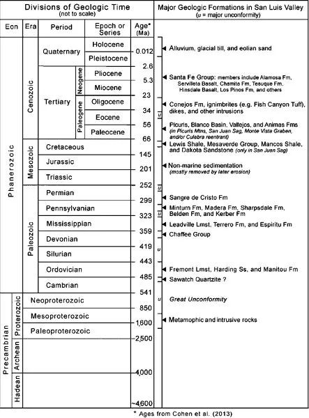
Figure 1.2. Stratigraphic chart showing the major bedrock formations in San Luis Valley. u; major unconformity.
Geologic time is informally subdivided into the Precambrian and Phanerozoic. The Precambrian started when the Earth formed nearly 4.6 billion years ago (4.6 Ga), and it ended about 541 million years ago (541 Ma) when a diverse assemblage of hard-shelled animals first appeared, marking the beginning of the Phanerozoic. The Precambrian consists of three time intervals: the Hadean, Archean, and Proterozoic Eons.
During the Hadean, planet Earth had just formed and was still very hot as a result of widespread volcanism, a partially molten surface, and frequent collisions with other solar system bodies. Rocks of Hadean age are not found in the Valley and are very rare on the planet. Archean rocks comprise the original North American craton, which consists of several assembled blocks, including the Wyoming Craton. The southern margin of the Archean craton lies in Wyoming and northwestern Colorado; hence Archean rocks do not exist in the Valley.
Proterozoic Eon
The SLV’s oldest rocks are 1.7 to 1.8 Ga Paleoproterozoic metamorphic and igneous rocks. Thus the first ~2.8 billion years (~61%) of Earth’s history are not recorded in the Valley’s rocks. Many of the metamorphic rocks were originally sedimentary or volcanic rocks that were deeply buried, then metamorphosed by ~1.7 Ga intrusions that are chiefly granitic. Mafic intrusions of this age exist in some areas.
Much of the Paleoproterozoic rock exposed in the Valley consists of foliated granitic rocks and gneiss in the core of the Sangre de Cristo Mountains. Paleoproterozoic metavolcanic rocks, pegmatite dikes and lenses, and metasedimentary rocks such as quartzite, metaconglomerate, and slate are also present. Metasedimentary rocks are widespread in the Picurís Mountains (Bauer and Williams 1989).
Mesoproterozoic plutons intruded the Paleoproterozoic rocks at ~1.4 Ga (e.g., Tweto 1980; Wobus 1984; Karlstrom et al. 2004; Lindsey 2010). Mafic gabbro dikes locally intruded the Paleoproterozoic crystalline rocks in the Sangre de Cristo Mountains. Some geologists assign a Neoproterozoic age to them (e.g., NMBG&MR 2003; Lindsey et al. 2012), while others classify them as Cambrian (Reed 1984) or undifferentiated early Paleozoic/Neoproterozoic (e.g., Wallace and Lindsey 1996; Kirkham et al. 2005b; Fridrich and Kirkham 2007; Thompson et al. 2015).
Whi...
Table of contents
- Cover
- Title Page
- Copyright Page
- Contents
- Foreword: “Wherever I Go, the Valley Goes with Me”
- Acknowledgments
- Introduction: The View from Blanca Peak
- Part I: Geology and Ecology of the San Luis Valley
- Part II: Human History of the San Luis Valley
- Part III: Travel Itineraries
- List of Contributors
- Index
Frequently asked questions
Yes, you can cancel anytime from the Subscription tab in your account settings on the Perlego website. Your subscription will stay active until the end of your current billing period. Learn how to cancel your subscription
No, books cannot be downloaded as external files, such as PDFs, for use outside of Perlego. However, you can download books within the Perlego app for offline reading on mobile or tablet. Learn how to download books offline
Perlego offers two plans: Essential and Complete
- Essential is ideal for learners and professionals who enjoy exploring a wide range of subjects. Access the Essential Library with 800,000+ trusted titles and best-sellers across business, personal growth, and the humanities. Includes unlimited reading time and Standard Read Aloud voice.
- Complete: Perfect for advanced learners and researchers needing full, unrestricted access. Unlock 1.5M+ books across hundreds of subjects, including academic and specialized titles. The Complete Plan also includes advanced features like Premium Read Aloud and Research Assistant.
We are an online textbook subscription service, where you can get access to an entire online library for less than the price of a single book per month. With over 1.5 million books across 990+ topics, we’ve got you covered! Learn about our mission
Look out for the read-aloud symbol on your next book to see if you can listen to it. The read-aloud tool reads text aloud for you, highlighting the text as it is being read. You can pause it, speed it up and slow it down. Learn more about Read Aloud
Yes! You can use the Perlego app on both iOS and Android devices to read anytime, anywhere — even offline. Perfect for commutes or when you’re on the go.
Please note we cannot support devices running on iOS 13 and Android 7 or earlier. Learn more about using the app
Please note we cannot support devices running on iOS 13 and Android 7 or earlier. Learn more about using the app
Yes, you can access Geology, Ecology, and Human History of the San Luis Valley by Jared Maxwell Beeton, Charles Nicholas Saenz, Benjamin James Waddell, Jared Maxwell Beeton,Charles Nicholas Saenz,Benjamin James Waddell in PDF and/or ePUB format, as well as other popular books in History & North American History. We have over 1.5 million books available in our catalogue for you to explore.