Trinacria, the ancient name for Sicily extending back to Homeric Greek, has understandably been the focus of decades of archaeological research. Recognizing Sicily's rich prehistory and pivotal role in the history of the Mediterranean, Sebastiano Tusa - professor, head of heritage agencies and councillor for Cultural Heritage for the Sicilian Region - promoted the exploration of the island's heritage through international collaboration. His decades of fostering research initiatives not only produced rich archaeological results spanning the Palaeolithic to the modern era but brought scholars from a range of schools and disciplines to work together in Sicily. Through his efforts, uniquely productive methodological, theoretical and interpretative networks were created. Their impact extends far beyond Sicily and Italy. To highlight these networks and their results, the Institutum Romanum Finlandiae, the Swedish Institute in Rome, the Norwegian Institute in Rome, the British School at Rome and the Assessorato dei Beni Culturali of Sicily, with generous support from the Swedish Riksbankens Jubileumsfond, assembled this anthology of papers. The aim is to present a selection of the work of and results from contemporary, multi-national research projects in Sicily. The collaboration between the Sicilian and international partners, often in an interdisciplinary framework, has generated important results and perspectives. The articles in this volume present research projects from throughout the island. The core of the articles is concerned with the Archaic through to the Roman period, but diachronic studies also trace lines back to the Stone Age and up to the contemporary era. A range of methods and sources are explored, thus creating an up-to-date volume that is a referential gateway to contemporary Sicilian archaeology.

eBook - ePub
Trinacria, 'An Island Outside Time'
International Archaeology in Sicily
- 240 pages
- English
- ePUB (mobile friendly)
- Available on iOS & Android
eBook - ePub
Trinacria, 'An Island Outside Time'
International Archaeology in Sicily
About this book
Trusted by 375,005 students
Access to over 1.5 million titles for a fair monthly price.
Study more efficiently using our study tools.
Information
Subtopic
Ancient HistoryIndex
Social Sciences1
Topographical research and geophysical surveys at Naxos in Sicily 2012–2019
Maria Costanza Lentini, Jari Pakkanen and Apostolos Sarris
Abstract
The collaborative project between the Archaeological Park of Naxos, the Finnish Institutes at Athens and in Rome and the GeoSat Research Lab at FORTH has over the years surveyed the whole urban area of the ancient settlement of Naxos in Sicily. The application of modern topographical survey methods and technologies and the multidisciplinary approach have both produced an insightful renewal of the research of the ancient city with the enhancement of the data previously collected in over 50 years of excavations. The measurement campaigns have been associated with geophysical surveys and short excavation campaigns including an environmental case study (2015–2016). This paper focuses on the results of both measurement campaigns and geophysical surveys. The measurement campaigns resulted in the first geo-referenced plan of the ancient city, which can be used to analyse the grid design of the Classical city. The field seasons in 2014, 2015 and 2016 included a major element of geophysical survey. Initially, the main aim was to find out which methods work best at Naxos and then cover as much territory as possible. The fastest method, magnetic gradiometry, is not able to detect archaeological features at Naxos due to the magnetic bedrock. Therefore, the methods used in 2015 and 2016 included soil resistivity and ground penetrating radar (GPR). During these years we covered approximately 10,000 m2. The new areas covered in 2016 were concentrated on the outskirts of the town. The results of the GPR especially have been highly encouraging: in many sectors we can see the walls of individual Classical houses, which follow the orientation of the 5th-century BC city grid. In the same season new data were acquired on the eastern extent of the Archaic South-West Sanctuary. The GPR has thus been shown to be effective even in detecting the oldest Archaic city.
This paper focuses on the results of the campaigns of measurement and geophysical survey conducted as part of the collaborative project between the Naxos Archaeological Park and the Finnish Institutes at Athens and in Rome. Reaching a more in-depth understanding of the urban landscape of ancient Naxos was the central objective of the project. The field research took place from 2012 to 2019. It produced a considerable range of new results and a better understanding of the ancient city compared to previous research. The application of modern topographic recording technologies and the multidisciplinary approach to the archaeological remains have been fundamental to obtaining these results. Equally important was building on the legacy of the in-depth and advanced research of the city reached in over 60 years of systematic excavations and fieldwork evident in the extensive range of publications on the site.
Naxos was the earliest of the Greek colonies in Sicily with a traditional foundation date of 734 BC (Thuc. 6.3.1). The settlers arrived from Chalcis in Euboea and Naxos in the Cyclades (Hellanicus FGrH 4 F 82). Its primacy and the special status of the altar of Apollo Archegetes at Naxos continued to be recognised by the later Greek colonies (Thuc. 6.3.1).1 The site is located on the east coast of Sicily between Messina and Catania: all ships sailing west following the coastline of south Italy would have first landed at Naxos.
The 5th-century history of Naxos was troubled and dramatic. It was first taken over by the tyrant of Gela, Hippocrates, in c. 492 BC (Hdt. 7.154) and in c. 476 BC Hieron of Syracuse forced the inhabitants to move to Leontinoi (Diod. Sic. 11.49.1–2). Even though the sources do not mention the establishment of the new regular layout of the city, it can be dated to soon after this date based on the material record. Therefore, it was highly likely a direct result of the establishment of the new Syracusan rule. The tyranny in Syracuse fell in 467 BC and the exiled Naxians were allowed to return in c. 461 (Diod. Sic. 11.76.3). The three Ionian cities of east Sicily, Naxos, Leontinoi and Katane, were allies of Athens in the Peloponnesian War and supported the campaign against Syracuse in 415–413 BC (Thuc. 4.65.1–2; 6.20.3). After the Athenian defeat in 403 BC, Dionysios of Syracuse completely destroyed Naxos (Diod. Sic. 14.15.2). Naxos did not recover from this destruction and the new urban centre, Tauromenion, was established across the bay on the hills to the north of Naxos in the 4th century BC. The area of the port was inhabited until the 6th century AD and there are some traces of settlement until the 8th century.2
The Classical city grid of Naxos is characterised by a system of three principal streets, plateiai, running approximately east–west with a series of north–south crossroads, stenopoi. The central plateia is named A, the one running in the southern section of the city is B and the northern one C. The stenopoi are numbered from west to east.
Updating the topography of the city
The ancient city of Naxos is located to the south of the modern town of Giardini Naxos. Based on recent topographical fieldwork, the area inside the city walls can be estimated as 36 ha on the promontory of Schisò bordered on the west side by the Santa Venera river and in the north extending to the north of the Shipshed complex and comprising the Larunchi Hill (Plate 1.1).3
The systematic excavations at Naxos were started in 1953 soon after the ones at Megara Hyblaia and Leontinoi.4 P. Pelagatti was the director of the excavations in 1961–1981, which resulted in the discovery of the two superimposed urban plans. The Archaic layout was polycentric (mid-7th century BC) and the Classical one was an orthogonal grid with elongated insulae (c. 470 BC).5 The city plan with both urban phases drawn up by Pelagatti – the plan that is the basis of the new geo-referenced map – has provided a very valuable tool for planning of further fieldwork as well as for safeguarding the site, which in 2007 became an archaeological park. The regularity of the later plan has made it possible to reconstruct the city layout also in the unexcavated zones, as has now been verified in the geophysical surveys of 2014–2016.
The recent fieldwork has greatly enhanced our knowledge of Naxos from the beginning of the first Greek settlement to its destruction in the late 5th century. The late Archaic Shipshed Complex (neoria)6 is located to the north of the most probable location of the agora at the northern edge of the city (Plate 1.1).7 The archaeological work in this sector has been critical for establishing the design pattern of the city of Naxos. It has made it possible to establish where the public hub was located in antiquity, emphasising the importance of the northern part of the city for civic and military functions and the link between the harbour and the agora. The bay must have played a central role in the ancient landscape of Naxos. The area north of the harbour is also the most likely location of the famous and never discovered altar of Apollo Archegetes.8
The extensive excavations in the central part of the Schisò promontory at the crossroads of plateia A and stenopos 11 have resulted in a large range of new data on the urban layouts and changes, from the first Greek settlement through the Archaic plan – which was only arranged per strigas in the early 6th century BC – to the highly regular Classical layout of the city (Plate 1.1).9
The topographical field seasons concentrating on the whole urban landscape of Naxos were carried out in 2012 and 2013. Since 2014, the total station measurement campaigns have largely concentrated on the area of the intersection A11 and on the Shipshed Complex as well as on the south-west sanctuary. Photogrammetry has been used for documentation of the archaeological remains since the 2014 season and aerial photogrammetry with a drone was used in 2017. The three-dimensional block-by-block line-drawing documentation using total stations can now be combined with textured photogrammetry models for large sections of the archaeological site (Plate 1.1).10
The principal aim of the geophysical survey conducted from 2014 to 2016 was to verify the extent of Classical buildings inside the ancient city walls and to test whether Archaic structures could be identified. During the 2014 explorative fieldwork season the quality of the collected signals was tested and it was determined that the fastest method, magnetic gradiometry, cannot give significant results at Naxos. The noise levels resulting from the magnetic bedrock and lenses created by the eruptions from Etna are too high. However, the results from soil resistivity and especially GPR were discovered to be highly effective in picking up the signals from the house foundations, and these two methods were used in 2015 and 2016 to cover as much ground as possible.
The intersection All and the evidence for the first colonial settlement
At the crossroads, the discoveries relating to the earlier phases of the colony have a particular importance and we focus on these. The data from the excavations carried out at plateia A, the nearby area to the north and the area just to the south of intersection A11 below a very large Byzantine landfill, give a surprising insight into the early landscape of the settlement after the phase of its establishment.
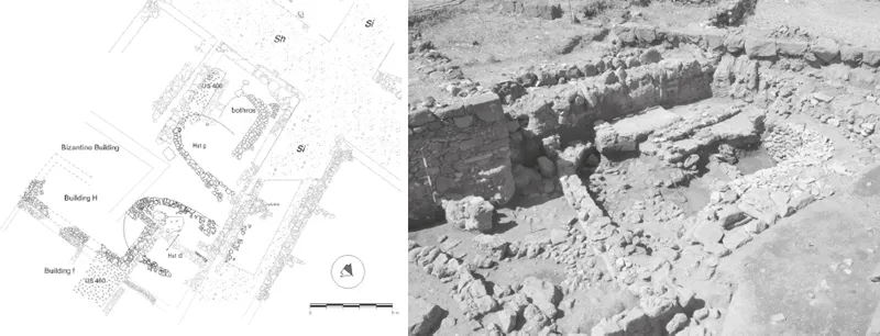
Figure 1.1. Naxos. Plan of the enclosure at the north-western corner of the crossroads of Street Si and Sh. View from the north of Hut g and the bothros.
Two curvilinear buildings ...
Table of contents
- Cover
- Title Page
- Copyright
- Contents
- Preface (Valeria Li Vigni Tusa)
- List of contributors
- Introduction (Arja Karivieri, Peter Campbell, Kristian Göransson and Christopher Prescott)
- In memory of Sebastiano Tusa, 2 August 1952–10 March 2019 (Paola Pelagatti)
- 1. Topographical research and geophysical surveys at Naxos in Sicily 2012-2019: Maria Costanza Lentini, Jari Pakkanen and Apostolos Sarris
- 2. Francavilla di Sicilia: a Greek settlement in the hinterland of Naxos: Kristian Göransson
- 3. The praedia Philippianorum: a late Roman estate at Gerace near Enna: R. J. A. Wilson
- 4. Akrai, south-eastern Sicily: a multidisciplinary study on the impact of ancient humans on the natural landscape: Roksana Chowaniec, Rafał Fetner, Girolamo Fiorentino, Anna Gręzak and Matilde Stella
- 5. The Marzamemi Maritime Heritage Project: from the seabed to the museum and beyond: Justin Leidwanger, Elizabeth S. Greene, Leopoldo Repola and Fabrizio Sgroi
- 6. The Hellenistic house in motion: reflections on the CAP excavations at Morgantina (2014-2019): D. Alex Walthall
- 7. The Morgantina baths in their urban context: Sandra K. Lucore
- 8. Sicily in the Iron Age and the concept of the Greek chora: Johannes Bergemann with a contribution by Rebecca Diana Klug
- 9. The Himera Project of the University of Bern: a collaboration with the Parco Archeologico di Himera: Elena Mango
- 10. Halaesa (Tusa, Messina): undertakings of the French Archaeological Mission, 2016-2019: the discovery of the theatre and problems in its excavation: Michela Costanzi
- 11. The research project led by the University of Zurich on Monte Iato: the last 10 years: Christoph Reusser
- 12. The gymnasion of Iaitas/Ietas discovered? New excavations in the eastern quarter on Monte Iato: Martin Mohr
- 13. The Salemi Survey Project: the longue durée of interior western Sicily 1500 BC-AD 1500: Michael J. Kolb, Pierfrancesco Vecchio and Rossella Giglio
- 14. The ‘Archaeological Map of Lilybaeum’: Donatella Ebolese, Mauro Lo Brutto, Antonella Mandruzzato, Debora Oswald and Martina Seifert
- 15. Mapping cross-channel connections: the Arizona Sicily Project, preliminary report of the 2018 and 2019 seasons: Emma Blake, Robert Schon and Rossella Giglio
- 16. The Battle of the Aegates Islands, 241 BC: mapping a naval encounter, 2005–2019: Sebastiano Tusa, Peter Campbell, Mateusz Polakowski, William M. Murray, Francesca Oliveri, Cecilia A. Buccellato, Adriana Fresina and Valeria Li Vigni
- 17. I.Sicily and Crossreads: a digital epigraphic corpus for ancient Sicily: Jonathan R.W. Prag
- Plate section
Frequently asked questions
Yes, you can cancel anytime from the Subscription tab in your account settings on the Perlego website. Your subscription will stay active until the end of your current billing period. Learn how to cancel your subscription
No, books cannot be downloaded as external files, such as PDFs, for use outside of Perlego. However, you can download books within the Perlego app for offline reading on mobile or tablet. Learn how to download books offline
Perlego offers two plans: Essential and Complete
- Essential is ideal for learners and professionals who enjoy exploring a wide range of subjects. Access the Essential Library with 800,000+ trusted titles and best-sellers across business, personal growth, and the humanities. Includes unlimited reading time and Standard Read Aloud voice.
- Complete: Perfect for advanced learners and researchers needing full, unrestricted access. Unlock 1.5M+ books across hundreds of subjects, including academic and specialized titles. The Complete Plan also includes advanced features like Premium Read Aloud and Research Assistant.
We are an online textbook subscription service, where you can get access to an entire online library for less than the price of a single book per month. With over 1.5 million books across 990+ topics, we’ve got you covered! Learn about our mission
Look out for the read-aloud symbol on your next book to see if you can listen to it. The read-aloud tool reads text aloud for you, highlighting the text as it is being read. You can pause it, speed it up and slow it down. Learn more about Read Aloud
Yes! You can use the Perlego app on both iOS and Android devices to read anytime, anywhere — even offline. Perfect for commutes or when you’re on the go.
Please note we cannot support devices running on iOS 13 and Android 7 or earlier. Learn more about using the app
Please note we cannot support devices running on iOS 13 and Android 7 or earlier. Learn more about using the app
Yes, you can access Trinacria, 'An Island Outside Time' by Christopher Prescott, Arja Karivieri, Peter Campbell, Kristian Göransson, Sebastiano Tusa, Christopher Prescott, Arja Karivieri, Peter Campbell, Kristian Göransson in PDF and/or ePUB format, as well as other popular books in Social Sciences & Ancient History. We have over 1.5 million books available in our catalogue for you to explore.