The Mountaineer Site presents over a decade's worth of archaeological research conducted at Mountaineer, a Paleoindian campsite in Colorado's Upper Gunnison Basin. Mountaineer is one of the very few extensively excavated, long-term Folsom occupations with evidence of built structures. The site provides a rich record of stone tool manufacture and use, as well as architectural features, and offers insight into Folsom period adaptive strategies from a time when the region was still in the grip of a waning Ice Age.
Contributors examine data concerning the structures, the duration and repetition of occupations, and the nature of the site's artifact assemblages to offer a valuable new perspective on human activity in the Rocky Mountains in the Late Pleistocene. Chapters survey the history of fieldwork at the site and compare and explain the various excavation procedures used; discuss the geology, taphonomic history, and geochronology of the site; analyze artifacts and other recovered materials; examine architectural elements; and compare the present and past environments of the Upper Gunnison Basin to gain insight into the setting in which Folsom groups were operating and the resources that were available to them.
The Folsom archaeological record indicates far greater variability in adaptive behavior than previously recognized in traditional models. The Mountaineer Site shows how accounting for reduced mobility, more generalized subsistence patterns, and variability in tool manufacture and use allows for a richer and more accurate understanding of Folsom lifeways. It will be of great interest to graduate students and archaeologists focusing on Paleoindian archaeology, hunter-gatherer mobility, lithic technological organization, and prehistoric households, as well as prehistorians, anthropologists, and social scientists.
Contributors: Richard J. Anderson, Andrew R. Boehm, Christy E. Briles, Katherine A. Cross, Steven D. Emslie, Metin I. Eren, Richard Gunst, Kalanka Jayalath, Brooke M. Morgan, Cathy Whitlock
eBook - ePub
Mountaineer Site
A Folsom Winter Camp in the Rockies
- English
- ePUB (mobile friendly)
- Available on iOS & Android
eBook - ePub
About this book
Trusted by 375,005 students
Access to over 1.5 million titles for a fair monthly price.
Study more efficiently using our study tools.
Information
Publisher
University Press of ColoradoYear
2021Print ISBN
9781646423095
9781646421398
eBook ISBN
9781646421404
1
Introduction
Brian N. Andrews, David J. Meltzer, and Mark Stiger
Over the last twenty-five years or so, it has become increasingly evident that hunter-gatherers across the North American West exploited and/or resided in high-altitude settings, which, following Aldenderfer (2006), we define as locations at elevations greater than 2,500 meters above sea level (e.g., Benedict 1992a, 1992b, 2007; Bettinger 1991; Cannon et al. 2015; LaBelle and Cassells 2012; Morgan et al. 2012; Pitblado 2016; Pitblado and Brunswig 2007; Stiger 2006; Stirn 2014; Thomas 2014). The question is no longer whether groups occupied the Rocky Mountains or the high mountains of the Great Basin, habitats long supposed to have been either avoided altogether or used briefly and perhaps only during times of stress elsewhere (e.g., Benedict and Olson 1978; Husted 1969, 1974; Kroeber 1939; Steward 1938). Rather, the issues now revolve around when those regions were first inhabited, how hunter-gatherers made use of these habitats and their resources, the adaptive (perhaps physiological ones) challenges these environments may have posed, and the duration and intensity of human occupation at different times (e.g., Andrews 2010; Kornfeld 2013, 2015; Morgan 2015; Pitblado 2016; Surovell 2009).
Recent research in the Rocky Mountains has demonstrated that although there are a few occurrences of isolated Clovis-age material in the region, the earliest substantial and securely documented human presence was by Folsom groups (Andrews 2010; Frison 2004; Jodry 1999b; Kornfeld 2015; Pitblado 2016; Pitblado and Brunswig 2007; Stiger 2006). In fact, most reported Folsom sites in Colorado are in the southern Rocky Mountains and not the Great Plains portion of the state. Folsom sites are present in the upper drainage basins of the Colorado, Arkansas, Rio Grande, Gunnison, and Platte Rivers. Likewise, almost all of the excavated Paleoindian residential structures in southern Wyoming, Colorado, and northern New Mexico are found in similar headwaters settings, perhaps indicating a focus on overwintering and exploiting aggregated animal resources (Stiger 2013).
Viewed over time, of course, the great majority of sites in the Rocky Mountains postdate the Paleoindian period and in fact fall later in the Holocene, with a frequency spike in the last millennia prior to the Contact period. Many of these sites were briefly occupied summer hunting localities or had other specialized uses (e.g., Benedict 1981, 1985, 1992a, 1992b, 1996, 2000; LaBelle and Pelton 2013; Morgan et al. 2012). Far less common were high-elevation residential villages; where these occur, they appear to be summer occupations as well, though not necessarily hunting camps. At High Rise Village and other high-altitude temporary residential localities in the Wind River Range of the Rocky Mountains, for example, groups were likely exploiting seasonally available plants such as geophytes or pine nuts (Morgan et al. 2012; Stirn 2014; comparable purposes and patterns are seen in the high-elevation villages of the Great Basin [e.g., Bettinger 1991, 2008; Thomas 2014, 2015]).
Those broad temporal patterns notwithstanding, the upper drainages of the southern Rockies, particularly the Upper Gunnison Basin (UGB), are an exception. There are more known and excavated Folsom than Late Prehistoric sites, along with a spike in occupation during the Early Archaic, ca. 8,000–5,500 radiocarbon years BP (Reed and Metcalf 1999; Stiger 2001). In this volume, we report on a still rarer phenomenon: a longer-term Folsom residence, the Mountaineer site.
The Mountaineer Site
Mountaineer is located in the Upper Gunnison Basin, a high-elevation region nearly surrounded by mountains on the western slope of the Continental Divide (figure 1.1). The site is at an elevation of ~2,625 meters above sea level (masl) atop an isolated mesa, Tenderfoot Mountain (referred to locally as “W” Mountain),1 which is situated at and overlooks the confluence of the Gunnison River and one of its major tributaries, Tomichi Creek.
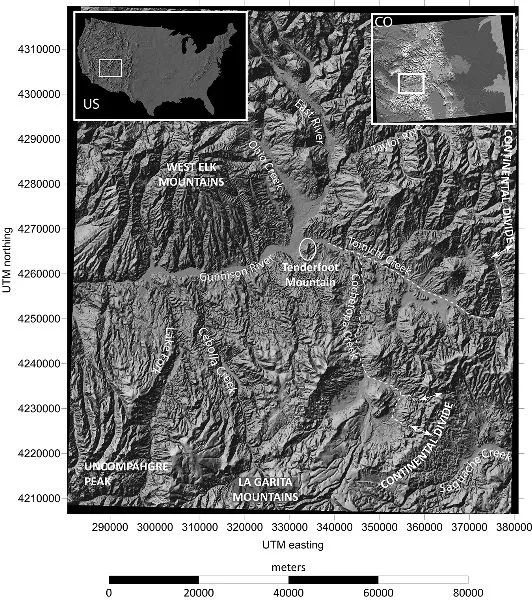
Figure 1.1. DEM location map of Tenderfoot Mountain in the Upper Gunnison Basin, Colorado
Tenderfoot Mountain rises to visual prominence almost 300 meters above the floor of the UGB (figure 1.2), which is itself at an elevation of ~2,350 masl. Despite the rise in elevation, the slopes of Tenderfoot Mountain are generally smooth, with routes to the top that are not particularly challenging (figure 1.3). Once on top, the surface is virtually level, though overall the northern end of the mesa is ~25 m higher than the southern end. Today, the mesa is covered in grass and sagebrush, with small groves of aspen, Douglas fir, and juniper scattered around its upper flanks, particularly in protected cornices.
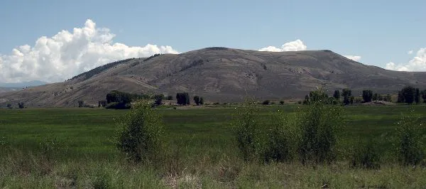
Figure 1.2. View of Tenderfoot Mountain rising above basin floor of the UGB, from the west

Figure 1.3. DEM of Tenderfoot Mountain and its immediate vicinity. Bottom: vertical profiles from the basin floor to the Mountaineer site (MTN), with 5× vertical exaggeration.
Tenderfoot Mountain is roughly lozenge-shaped in plan, ~1.25 km long and ~0.45 km wide, its long axis oriented a few degrees east of north. A perimeter walk around the mesa top (a distance of ~2.64 km) offers a commanding view of ~800 km2 of the surrounding landscape. Just how much of that area could have been seen in earlier times would, of course, have depended on the amount of obscuring vegetation (figure 1.4). The view to the north and west today includes the relatively level floor of the basin and the Gunnison River coming down from the north and, to the north and east, Tomichi Creek, which flows from east to west along the northwest edge of Tenderfoot Mountain and joins the Gunnison River a few kilometers west of the site. To the east, south, and southwest, the view from the top takes in numerous small drainages and low hills. This 360° vantage from atop Tenderfoot Mountain was perhaps what attracted foragers to this spot in prehistoric times, as it would have allowed them to observe any large game moving across the basin floor below.
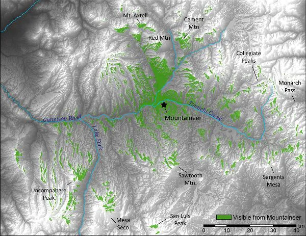
Figure 1.4. Viewshed from a walk around the 2.64-km perimeter of Tenderfoot Mountain. The area in dark gray (811.5 km2) is visible from the top of the mountain, indicating the extent of the immediate area hunter-gatherers could have watched for game, as well as more distant areas they could have monitored for evidence of fire, changes in the weather, or evidence of snowfall that might be expected to drive animals down to lower elevations. GIS analysis and image courtesy of Leslie Reeder-Myers.
The idea that past groups spent time atop Tenderfoot Mountain was first noted in 1992 by archaeologists from Western State College in Gunnison (now Western Colorado University, hereafter WCU). In 1994, following a survey associated with the construction of wireless phone towers atop Tenderfoot Mountain, the Mountaineer site was formally recorded as 5GN2477. It was initially classified as a rhyolite quarry and non-diagnostic lithic scatter. However, closer inspection in 2000 revealed flaked stone concentrations on the surface associated with Folsom fluted projectile points and preforms (Stiger and Bjornstad 2002, 2003). Subsequent intensive surface surveys indicated that multiple dense and spatially discrete clusters of Folsom-age artifacts were present along with scattered artifacts of later periods.
Since 2000, much of the surface of Tenderfoot Mountain has been systematically surveyed, and over 640 m2 have been excavated in five Folsom-specific cultural areas (designated Blocks A, B, C, D, and F). As part of these investigations, an additional 31 m2 were excavated in two archaeologically barren “control” areas (Blocks X and Y). Over the course of investigations in the Folsom areas, more than 100,000 stone artifacts were recovered from surface and excavated contexts, including 108 Folsom fluted projectile points and preforms and almost 800 stone tools (Andrews 2010; Morgan 2015). The Folsom components of the Mountaineer site are scattered over ~17 hectares, making it one of the most spatially extensive known Folsom sites (Andrews et al. 2008).
More intriguing, some of the clusters (in excavation Blocks A, B, C, and F) appear to have harbored structures. Block A, the first to be excavated, yielded a range of stone artifacts including Folsom projectile points and preforms, knives, scrapers, and other tools, along with remains of a hearth in an area ~3 m in diameter, cleared of the naturally occurring surface rocks (Stiger 2002). Subsequently and just to the north, excavations revealed a roughly circular distribution of large rocks (>35 cm in maximum dimension) roughly ~6 m in diameter, which included artifacts along with charcoal, bone, and burned mud (clay) daub. The latter discovery was interpreted as the remains of a Folsom-age dwelling, with the large rocks apparently arranged to form the foundation and lower walls, thought to have anchored wooden poles that served as its upper walls (Stiger 2006). The inference was warranted by several daub fragments that preserved the rounded form and bark imprint of aspen poles (Stiger 2006:figure 8; chapter 7, this volume).
Assuming that this interpretation is correct, Mountaineer would be a rare instance of a Paleoindian site that produced traces of a habitation structure (notable other occurrences with more or less compelling evidence of the remains of structures include the Folsom component at Agate Basin, Wyoming [Frison 1982a]; the Folsom site of Barger Gulch, Colorado [Surovell and Waguespack 2007; Waguespack and Surovell 2014]; the eastern fluted point occupations at Bull Brook, Massachusetts [Robinson et al. 2009], and Thunderbird [Gardner 1983]; and the Folsom/Midland component at Hell Gap, Wyoming [Irwin-Williams et al. 1973]).
The lack of Folsom or other Paleoindian habitation structures is assuredly not because Late Pleistocene hunter-gatherers never sought shelter. Rather, and granting sampling issues, it is likely because they were highly mobile peoples who may have only briefly occupied a place on the landscape. Being less “place-oriented” (Hill et al. 2011:766), they rarely needed to invest the labor to construct substantial, longer-lasting dwellings (Surovell 2009:66–67). We do not assume that the evidence from Mountaineer is indicative of year-long residence at this particular spot, but that is not to preclude the possibility that it was an element of longer-term residence in the UGB (see also Kornfeld 2015:323).
Subsequent survey and excavations in the other areas at Mountaineer by WCU and Southern Methodist University (SMU, under the auspices of the Quest Archaeological Research Program) documented several more areas of the site with architectural and artifact patterns similar to those in Block A. That finding, along with clues that these marked multiple, possibly contemporaneous Folsom-age structures at the site—perhaps occupied for an extended period of time—makes the Mountaineer site unusual and worthy of archaeological attention.
Paleoindians in the Rockies
That said, the presence of a Folsom site in the Rocky Mountains and more specifically in the southern Rocky Mountains is not unprecedented (Andrews 2010; Pitblado 2016; Pitblado and Brunswig 2007). Reports of isolated surface finds of Folsom and “Folsom-like”2 points in the region began to appear in the 1930s and 1940s, following the widespread recognition of the age and significance of these distinctive forms (Hurst 1941, 1943, 1945, 1947; Huscher 1939; Wormington 1944, 1949). However, early on it was uncertain whether there had been a Paleoindian presence in the mountains, an idea most vigorously promoted by Hurst (e.g., 1943), or if these isolated finds were—as Wormington (1944:11, 1949:24) suggested—dropped by visiting hunters who were otherwise “largely, although not entirely, confined to the High Plains area.”
This question arose because early discoveries of Paleoindian sites were largely confined to the Great Plains and were associated with the bones of large mammals. This pattern was a consequence of the manner in which Paleoindian sites were then often found: by searching for artifacts at localities where large mammal bones had been spotted (Meltzer 2006a, 2006b). It led to the inference that Paleoindians were big-game hunters, and as their prey were considered denizens of the Plains grasslands, it was likewise assumed that this was the region principally inhabited by Paleoindians, a view codified in syntheses in the 1940s and 1950s (e.g., Roberts 1940; Sellards 1952; Wormington 1939, 1944, 1949).
More important, however, this view was not just about where Paleoindians were. There was also a strongly held view of where they were not: the Rocky Mountains. That notion was first explicitly expressed in the mid-1950s by Jennings and others (1956) as the Desert Culture concept. The Desert Culture involved the “intensive exploitation of the environment, [which was] nonspecialized in the sense of no major reliance on one resource, but close adaptation to everything available including small mammals such as rodents” (Jennings et al. 1956:70). That adaptation was thought to extend over an area “from Oregon to the Valley of Mexico and from the eastern foothills of the Rocky Mountains to the Pacific Coast” (Jennings et al. 1956:69). The Desert Culture was “distinguishable in its culture pattern from the big-game huntin...
Table of contents
- Cover
- Title Page
- Copyright Page
- Contents
- Acknowledgments
- 1. Introduction
- 2. Geology, Site Formation, and Geochronology
- 3. The Environmental Context
- 4. Archaeological Research Design and Field Methods
- 5. Blocks X and Y
- 6. Spatial Characterization of the Large Rock Patterns in Blocks C, X, and Y
- 7. Block A
- 8. Block B
- 9. Block C
- 10. Block D
- 11. Block F
- 12. The Mountaineer Folsom Projectile Point Assemblage
- 13. A Quantitative Test of Folsom Unifacial Tool Recycling in Block C
- 14. The Mountaineer Faunal Remains
- 15. The Mountaineer Site: Summary and Conclusions
- Appendix: Field Procedures and Protocols
- References
- Index
- Authors
Frequently asked questions
Yes, you can cancel anytime from the Subscription tab in your account settings on the Perlego website. Your subscription will stay active until the end of your current billing period. Learn how to cancel your subscription
No, books cannot be downloaded as external files, such as PDFs, for use outside of Perlego. However, you can download books within the Perlego app for offline reading on mobile or tablet. Learn how to download books offline
Perlego offers two plans: Essential and Complete
- Essential is ideal for learners and professionals who enjoy exploring a wide range of subjects. Access the Essential Library with 800,000+ trusted titles and best-sellers across business, personal growth, and the humanities. Includes unlimited reading time and Standard Read Aloud voice.
- Complete: Perfect for advanced learners and researchers needing full, unrestricted access. Unlock 1.5M+ books across hundreds of subjects, including academic and specialized titles. The Complete Plan also includes advanced features like Premium Read Aloud and Research Assistant.
We are an online textbook subscription service, where you can get access to an entire online library for less than the price of a single book per month. With over 1.5 million books across 990+ topics, we’ve got you covered! Learn about our mission
Look out for the read-aloud symbol on your next book to see if you can listen to it. The read-aloud tool reads text aloud for you, highlighting the text as it is being read. You can pause it, speed it up and slow it down. Learn more about Read Aloud
Yes! You can use the Perlego app on both iOS and Android devices to read anytime, anywhere — even offline. Perfect for commutes or when you’re on the go.
Please note we cannot support devices running on iOS 13 and Android 7 or earlier. Learn more about using the app
Please note we cannot support devices running on iOS 13 and Android 7 or earlier. Learn more about using the app
Yes, you can access Mountaineer Site by Brian N. Andrews,David J. Meltzer,Mark Stiger in PDF and/or ePUB format, as well as other popular books in Social Sciences & Archaeology. We have over 1.5 million books available in our catalogue for you to explore.