![]()
PART I THE ORIGINS OF URBAN POLITICS AND POLICY
CHAPTER 1 Cities and Urbanization in the United States: A Statistical Overview
CHAPTER 2 Cities in the Early Republic
CHAPTER 3 Industrial Cities
CHAPTER 4 Neoliberal Cities
![]()
chapter 1
Cities and Urbanization in the United States
A Statistical Overview
by Todd Gardner
URBAN GROWTH IN THE UNITED STATES HAS been strongly influenced by technological developments, particularly improvements in transportation systems. As a result, distinct regional patterns of metropolitan development have emerged throughout U.S. history as metropolitan areas have emerged at different times in different parts of the country. Industrialization brought rapid urban growth first to the northeastern part of the country and then to the Great Lakes region, establishing the Industrial Belt. By the twentieth century, metropolitan growth was occurring rapidly along the Pacific coast. Though development in the South and West generally lagged behind that of the rest of the country, several cities in these areas grew rapidly before World War II, setting the stage for the emergence of the Sunbelt in recent decades. In the past century, most urban growth has occurred outside of the boundaries of traditional urban cores, resulting in decentralized, politically fragmented metropolitan regions.
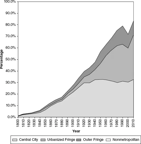
In 1950, the U.S. Census Bureau introduced the Standard Metropolitan Area to tabulate statistics for large cities and their suburbs. The standards for delineating metropolitan areas have changed somewhat since then, as these areas have gone by different names at different times: Standard Metropolitan Statistical Areas (SMSA), then Metropolitan Statistical Areas (MSA), and Core Based Statistical Areas (CBSA). Despite the changes, these definitions are roughly comparable from decade to decade. No consistent metropolitan definition existed prior to 1950, however, so this analysis uses a standardized metropolitan definition based on an earlier classification the Census Bureau used before 1950 called the “Metropolitan District.”1 Pulling together all of these definitions, Figure 1.1 shows the growth of the metropolitan population in the United States from 1800 to 2010.
Despite the comparability problems of this approach, the following metropolitan growth eras are evident in Figure 1.1:
• Urban concentration to 1880,
• Metropolitan emergence from 1880 to 1920,
• Early suburban expansion from 1920 to 1950, and
• Automobile-oriented suburban growth from 1950 to the present.
Prior to industrialization, densely populated cities grew rapidly, while the population of the urban fringe remained small. Until 1840, urban growth was limited to a few port cities, but beginning in the middle of the nineteenth century, inland river cities and urban centers in the Great Lakes area emerged. From 1880 to 1920, industrialization gave rise to several large urban centers. In this period, central cities continued to grow, and the proportion residing in fringe areas increased as many cities built streetcar systems. After 1920, growth stagnated in urban cores, while growth rates in fringe areas increased. After World War II, suburban growth accelerated, and urban development expanded outward from core areas as a result of widespread automobile ownership and the construction of the Interstate Highway System. Within these broad outlines, there are, of course, a collection of varying metropolitan centers, each with its own unique history of development.
EARLY PORT CITIES, 1800–1840
The earliest urban growth occurred in port cities such as New York, Philadelphia, Boston, and Baltimore in the northeastern part of the country and New Orleans in the South. Until the late nineteenth century, urban growth was constrained by the lack of mass transportation systems. Urban development extended only as far as a person could comfortably walk to reach necessary destinations. These compact “walking cities” rarely extended beyond a three-mile radius. The percentage of the population residing on the metropolitan fringe was small, never rising above three percent of the total national population.
In the earliest censuses taken in the United States, New York and Philadelphia were the largest urban centers. Though New York has always claimed the title of the largest city in the United States, Philadelphia and its adjacent densely populated suburbs actually accounted for a larger population than New York before 1810. The 1790 census reported that 42,520 people lived in Philadelphia and its suburbs, while the population of New York was only 33,131 that year. In 1800, the combined population of Philadelphia, Northern Liberties, and Southwark was 61,559 people, while New York’s population was 60,489 in that year. New York was somewhat unique among large cities in that it had a relatively large jurisdiction early in its history, including the entire island of Manhattan, although much of this territory was undeveloped throughout most of the nineteenth century. Brooklyn was largely rural until commuter service to New York was established in 1814, initiating a period of rapid population growth.
In his classic history of the American suburbs, Crabgrass Frontier (1985), Kenneth Jackson asserts that Brooklyn was the first commuter suburb, but a number of Philadelphia suburbs predate Brooklyn. During the first half of the nineteenth century, Philadelphia was a city with a land area of only two square miles (the area now referred to as “Center City”), around which densely populated suburbs developed. Southwark was incorporated in 1762, followed by Northern Liberties in 1803, Moyamensing in 1812, and Spring Garden in 1813, whereas the city of Brooklyn was not incorporated until 1836, making it something of a latecomer. Jackson acknowledges the early growth of Philadelphia’s suburbs, but he emphasizes that these communities were poor, while Brooklyn was populated by wealthy commuters. In 1854, the Pennsylvania state legislature consolidated the city and county of Philadelphia, increasing the land area of the city to nearly 130 square miles.
Boston began annexing nearby communities much earlier than Philadelphia. The original city of Boston was located on a small peninsula in Boston Harbor. South Boston was annexed to the city in 1804 and East Boston in 1836. These early annexations had only a small impact on Boston’s population growth, though. East Boston and South Boston made up only a single ward and, by 1850, accounted for less than 10 percent of the city’s population. Boston’s main period of territorial expansion occurred between 1867 and 1876. During these years, Boston annexed Roxbury (1867), Dorchester (1869), Charlestown (1873), West Roxbury (1873), and Brighton (1876), increasing the area of the city from 7 to 38 square miles and adding well over 100,000 persons to the population of the city.
After 1810, New York City has maintained the status of being not only the largest city in the United States but also the center of the largest metropolitan region in the country. Though the communities near New York City were small, their populations were growing at a more rapid rate than the city itself, particularly after 1830. In 1847, the New York Tribune complained about the growth of suburban areas coming at the expense of the city:
Among neighboring communities, Brooklyn’s growth was especially rapid, and by the latter half of the nineteenth century, it had become a major city in its own right. At the time of the consolidation of New York City and the outer boroughs in 1898, Brooklyn was the fourth-largest city in the country.
Although urban development was quite dense, the largest cities—New York, Philadelphia, and Boston—already had substantial metropolitan fringe populations by the middle of the nineteenth century. While these early suburbs were residential communities, historian Henry Binford points out that they were distinct from the commuter suburbs of the Industrial Era. Prior to the development of residential suburban communities, the term “suburb” meant an undifferentiated zone on the outskirts of an urban center, a zone of transition between the urban center and the rural countryside. As Binford describes, however, these early suburbs did have distinct identities.3 A British traveler made the following observation:
Binford goes on to say that although early suburbs were crucial in the development of commuter suburbs of the Industrial Era, they constituted a unique municipal form. The suburban communities often initiated the transportation links between city and suburb. Mid–nineteenth-century suburban communities were based primarily on agriculture, taking advantage of the large nearby market.
In contrast to New York, Philadelphia, and Boston, which grew rapidly and had extensive metropolitan areas by the middle of the nineteenth century, were Baltimore and New Orleans, which grew less rapidly and experienced little of the political fragmentation that accompanied the process of metropolitan growth in the northeast. Areas adjacent to these cities were lightly populated, and few communities on the periphery became independent, incorporated municipalities. The city of Baltimore separated itself from its suburbs in another way, however, when it became independent of Baltimore County in the 1860s. Baltimore City expanded its territorial boundaries only twice in its history. In 1888, 18 square miles of Baltimore County were added to the city, and another 48 square miles were annexed in 1918. Because of the slow growth of this area, these annexations were sufficient to maintain a majority of the metropolitan population within the political boundaries of the central city. As with Baltimore, the slow growth of New Orleans resulted in the concentration of population within the political boundaries of the central city, even though the city annexed relatively little territory.
URBAN CONCENTRATION TO 1880
In the middle of the nineteenth century, the fastest metropolitan growth occurred among inland river cities. Not only did St. Louis, Cincinnati, and Pittsburgh have much higher growth rates than did the older coastal cities in this period, but these areas also had substantial fringe populations. In many cases, the river created a barrier to a city’s expansion. In some metropolitan areas, the river formed a state boundary, and some neighboring communities across the river became cities in their own right, such as Covington and Newport, Kentucky, near Cincinnati; and New Albany and Jeffersonville, Indiana, in metropolitan Louisville. East St. Louis, across the Mississippi River from St. Louis and lying in Illinois, did not begin to grow rapidly until the late nineteenth century, while St. Louis captured much of its outlying growth by annexing large parts of St. Louis County, culminating in a large annexation in 1876 and a subsequent separation of the city and county, as in the case of Baltimore. St. Louis has not substantially changed its boundaries since then.
In the latter part of the nineteenth century, the most rapid metropolitan growth occurred in the Great Lakes area, and Chicago emerged as the most dynamic urban center in the nation. After the Great Fire of 1871, much of Chicago had to be rebuilt, but even this catastrophic event barely slowed the pace of its growth. Historian Michael Ebner has pointed out that the benefits of suburban living received a great deal of attention after the fire. In 1873, the Chicago Sun Times took stock of the metropolitan growth of Chicago, acknowledging the role of railroads in the growth of the city.