![]()
17 LOUGHCREW CAIRNS
COUNTY MEATH
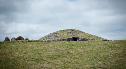
Cairn T at Loughcrew
The incredible passage-tomb cemetery of Loughcrew is located near the village of Oldcastle in County Meath. The most striking features of the archaeological landscape of Loughcrew are the three large cairns that dominate the summit of three steep hills, Patrickstown, Carnbane West and Carnbane East. The most visited is Carnbane East because it has the largest of the tombs, Cairn T, the focal point of the whole cemetery.
Cairn T dates back to approximately 3000 BC. On the summit of Carnbane East, Cairn T is surrounded by a number of smaller tombs. The large cairn measures around 35 metres (115 ft) in diameter, and this passage tomb has a cruciform chamber and some of the finest examples of Neolithic art in Ireland. Visit during the autumn or spring equinox to witness sunlight entering the chamber to illuminate the inside of the tomb (cloud cover permitting).
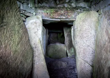
Entering the tomb itself is an atmospheric experience: the passageway is lined with large orthostats that display intricate carvings of spirals, lines, lozenges, zigzags, circles and cup marks.
The passageway to the burial chamber at Loughcrew
The Hag’s Chair is one of the kerbstones that surround Cairn T; it displays megalithic art but unfortunately the carvings are very difficult to make out today, except near the base, if the light is strong enough. The cross inscribed on the seat is clearer. It possibly represents the use of the stone as a Mass Rock during penal times. It was also thought to have been used as a ceremonial or inauguration chair during the early medieval period.
The Irish name of Loughcrew, Sliabh na Calliagh, is thought to derive from Sliabh na Caillí, ‘The Hill of the Witch’. Folklore has it that the monuments at Loughcrew were formed when a witch called An Cailleach Bhéara was challenged to drop an apron full of stones on each of the three Loughcrew peaks: if she succeeded she would be proclaimed the ruler of all Ireland. She was successful on the first two peaks, but missed the third and fell to her death.
Loughcrew is one of the most rewarding sites to visit in Ireland, and a true must-see for anyone who visits the Boyne Valley. In comparison to Newgrange, Loughcrew is rarely visited, and offers perhaps a more intimate experience with the Neolithic passage-tomb builders. There are free guided tours by OPW staff between 30 May and 28 August. At other times of the year, the key must be collected from Loughcrew Gardens Coffee Shop (a deposit and identification are required). Please note that the walk up to the site is quite steep so suitable footwear should be worn.
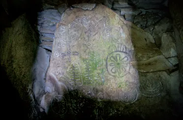
The highly decorated Equinox Stone
The site affords some spectacular views of County Meath as well as a truly wonderful archaeological experience.
LOUGHCREW CAIRNS
SITE MAP 3
Coordinates: Lat: 53.744677, Long: -7.112322
Grid reference: N 58549 77595
Opening times: Open all year round. An OPW guide is at the site from 30 May to 28 August. For the rest of the year, a key can be obtained from Loughcrew Gardens Coffee Shop. A deposit must be left to get the key and is refundable when the key is returned.
Entry fee: Free
Facilities: None, but there is a coffee shop, as well as toilets and gardens, close to the site. Please see www.loughcrew.com for more information.
Car parking: There is a small car park at the site
Directions: To get to Loughcrew from Oldcastle, travel south on the R195 for about 2km. Turn left onto the L2800 and continue on this road for another 3km, keeping left at the fork to reach the car park.
Nearest town: Oldcastle, about 6km to the north
18 KELLS
COUNTY MEATH
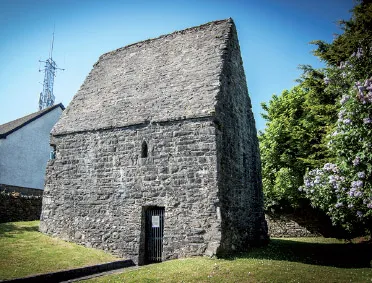
St Colmcille’s House in Kells, County Meath
Kells has a treasure trove of superb heritage sites to discover. Kells, or Ceanannas Mór (meaning ‘Great Fort’), was associated with legendary figures from the Irish sagas like Conn of the Hundred Battles and Cormac Mac Airt. Evidence of the importance of the area during the prehistoric period can be seen in the enormous hillfort on the Hill of Lloyd to the north-east of the town. Legend has it that Queen Medbh and her armies camped on the hill on their way to steal the Brown Bull of Cooley in the Táin Bó Cúailnge saga. More recently, Edward Bruce, brother of Robert the Bruce, also camped on the hill, following his victory over the Anglo-Normans at the Battle of Kells in 1315. Today the Spire of Lloyd, a wonderfully quirky inland lighthouse constructed in 1791, stands at the summit of the hillfort and gives outstanding views over the landscape.
The town of Kells rose to prominence in the early medieval period. The High King Diarmuid Mac Caroll is said have granted the dún (fort) of Ceanannas to St Colmcille (also known as St Columba) in the sixth century to establish a monastery. Little remains to be seen of the earliest phases of this once great monastery. Excavations behind St Colmcille’s House (see p. 57) in the late 1980s uncovered some seventh-century activity; however, the clearest evidence comes from the ninth century onwards. St Colmcille’s community on the island of Iona (off the western coast of Scotland) had been repeatedly raided by the Vikings, and in 804 the monks were granted land at Kells. By 878 the raids on Iona had become so frequent that the relics of Colmcille were moved from Iona to Kells (presumably including the famous Book of Kells now on display at Trinity College Dublin).
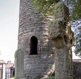
The round tower and South Cross in Kells
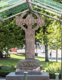
The Market Cross in Kells
By the early tenth century, Kells became an important monastery. One of the key features remaining from this period is the remarkable round tower. It probably served as a bellhouse and would have been an obvious marker in the landscape to weary pilgrims travelling to visit the sacred relics of St Colmcille. This tower also has a darker story, for it is within it that Murchad Ua Máel Sechnaill, King of Mide and High King of Tara, was murdered in 1076.
Close to the tower is one of the early medieval high crosses at Kells. This, the South Cross, was crafted in the ninth century. It was the only high cross to have borne the name of its maker, having once borne an inscription in Latin (now sadly worn away) that read ‘Muirdeach made this’.
Two other early medieval high crosses are within the walls of the monastic site: the North Cross, which has biblical depictions, and the so-called ‘unfinished cross’, which is located just to the side of the eighteenth-century church.
Perhaps the finest high cross at Kells is now located just outside the Old Courthouse. It originally stood in the centre of the crossroads in the town but was moved to its present location to protect it from damage from traffic. The cross is ninth-century and stands almost 3.5 metres (11.5 ft) tall. It depicts stories from the Bible, but also displays some more unusual designs, like the Celtic spirals, which may have drawn their influence from the tombs of the Boyne Valley. It also displays wrestling figures, horsemen with shields, centaurs and a wonderful depiction of a deer hunt.
Along with the monastic site, Kells also boasts a rare example of an early Irish church known as St Colmcille’s House, located on Church Lane. The stone-built church possibly dates to as early as the ninth century, and local tradition has it that it was in this building that the Book of Kells was completed.
KELLS
SITE MAP 3
Coordinates: Lat: 53.727175, Long: -6.877011
Grid reference: N 58549 77595
Opening times: Open all year round
Entry fee: Free
Facilities: Coffee shops and toilets located in the town. See: www.visitingkells.ie for more information about facilities.
Car parking: Car parking throughout Kells
Directions: Kells is located just off the M3 motorway and all the sites in the town are within walking distance
Nearest town: Trim, about 27km to the south
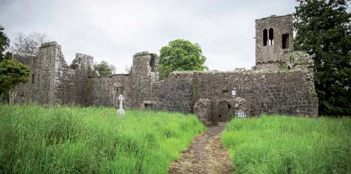
19 RATHMORE CHURCH
COUNTY MEATH
Rathmore Church, County Meath
Rathmore Church is situated outside the town of Athboy in rolling Meath pastureland. The c...