Thinking Like a Geographer focuses on high-interest, career-related topics in the elementary curriculum related to geography. Students will explore interdisciplinary content, foster creativity, and develop higher order thinking skills with activities aligned to relevant content area standards. Students will develop and practice geography skills, such as reading and creating maps, graphs, and charts; examining primary and secondary sources; and thinking spatially on a variety of scales. Thinking Like a Geographer reflects key emphases of curricula from the Center for Gifted Education at William & Mary, including the development of process skills in various content areas and the enhancement of discipline-specific thinking and habits of mind through hands-on activities.
Grade 2
eBook - ePub
Thinking Like a Geographer
Lessons That Develop Habits of Mind and Thinking Skills for Young Geographers in Grade 2
- 132 pages
- English
- ePUB (mobile friendly)
- Available on iOS & Android
eBook - ePub
Thinking Like a Geographer
Lessons That Develop Habits of Mind and Thinking Skills for Young Geographers in Grade 2
About this book
Trusted by 375,005 students
Access to over 1.5 million titles for a fair monthly price.
Study more efficiently using our study tools.
Information
UNIT 1
WHAT DO GEOGRAPHERS DO?
DOI: 10.4324/9781003239055-1
RATIONALE
This unit will introduce students to the study of geography in a way that makes geography applicable to their lives. This foundational understanding will help students apply geographic skills throughout the curriculum.
PLAN
Students will develop a definition for the profession of a geographer using a Frayer model. They will learn that geographers study the Earth’s surface, observe patterns in physical and human systems, ask questions about the Earth and its people, gather and organize geographic information, and analyze the data to answer questions. In Lesson 1.1, students will be introduced to the concept of “geographer.” In Lesson 1.2, students will be introduced to geographic inquiry processes. Students will read a sample story and then create geographic questions of their own to be investigated in the final project at the end of the units.
LESSON 1.1
WHAT IS A GEOGRAPHER?
DOI: 10.4324/9781003239055-2
RESOURCES AND MATERIALS
- Lesson 1.1 Frayer Model
- GPS navigation system or application (e.g., Google Maps)
- Video: “What Does It Mean to Be a Geographer?” (https://www.youtube.com/w atch?v= Jy9iOHD2ZN8)
ESTIMATED TIME
25-30 minutes
OBJECTIVES
In this lesson, students will:
- use a Frayer model to develop a definition of what geographers do in their careers,
- learn about the characteristics of individuals who work in the field of geography, and
- understand that geographic inquiry is a multistep process.
PRIOR KNOWLEDGE
Vocabulary: navigation, geographer, characteristics, example, nonexample, career
INSTRUCTIONAL SEQUENCE
- Show students a navigation application, such as Google Maps, or a GPS device. Ask: When are these kinds of applications used? Allow several volunteers to share examples. Students may mention needing to navigate in a new location or trying to find the fastest route to a location in busy traffic.
- Tell students: The study of the Earth is known as geography. The people who help create these navigation apps are known as geographers because they study the Earth and then use that information to help people and the environment.
- Distribute Lesson 1.1 Frayer Model. Draw or project a version of the handout onto the board for all students to see.
- Ask student volunteers to share words describing the characteristics of people who study Earth. Possible responses might include: people who are adventurous, people who also like science, people who like to talk to other people, people who like to travel, etc. Write responses on the board so that students can follow along and complete the “Characteristics” quadrant of their Frayer models.
- Play the video “What Does It Mean to Be a Geographer?” on mute so that students can see (but not hear) images of geographers working. Flave students work in pairs to complete the “Examples” and “Nonexamples” quadrants of the Frayer model, using what they see in the video. Replay the video on a continuous loop throughout this step.
- Flave students share their definitions of “geographer” with the class. Then, play “What Does It Mean to Be a Geographer?” with the sound on. Have students compare their responses about the characteristics and tasks of geographers to the description in the video. (Note. The video uses complex and content-specific vocabulary that might require definition or explanation, even for advanced students.)
EXTENSION ACTIVITIES
- Contact a local university and invite a geography professor or student to present to your class about what he or she is studying or hopes to do as a career.
- Contact your state geographic alliance for resources to share with students.
ASSESSMENT OBSERVATION
Students should identify at least three things from the video as examples of tasks geographers might do as part of their work. Possible answers include: traveling to different countries, observing people and other living creatures, flying over different types of land, working with different groups of people, teaching in schools, working with maps and globes, or studying the weather and climate.
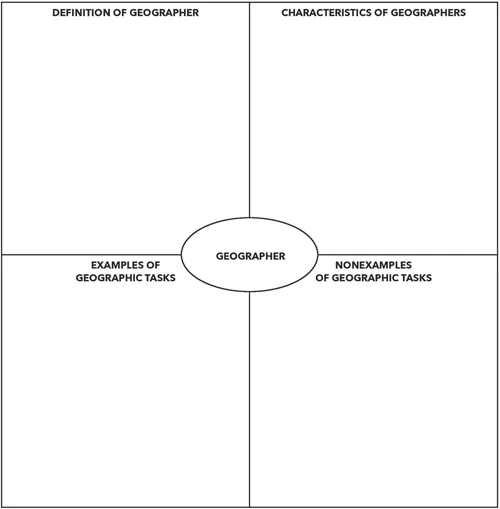
LESSON 1.1
Frayer Model
Frayer Model
NAME: ___________ DATE: _____________
Directions: Complete the following Frayer model for "geographer." Consider the definition and characteristics of a geographer, as well as examples and nonexamples of geographic tasks.
LESSON 1.2
THE PROCESS OF GEOGRAPHIC INQUIRY
DOI: 10.4324/9781003239055-3
RESOURCES AND MATERIALS
- Lesson 1.2 Geography in Action
- Dictionary
ESTIMATED TIME
35-40 minutes
OBJECTIVES
In this lesson, students will:
- consider a scenario that models the geographic inquiry process in the classroom from a student’s perspective,
- reflect on the geographic process used, and
- develop possible geographic questions to explore in a future project.
PRIOR KNOWLEDGE
Vocabulary: inquire, inquiry
Skills: geographic inquiry (similar to scientific inquiry, with which students may have some experience)
INSTRUCTIONAL SEQUENCE
- Ask students: What does it mean to inquire or to be inquisitive? Use a dictionary or another resources if needed to establish that inquiring involves asking questions. Tell students: You will learn about the process that geographers use to do their jobs. This process involves asking questions, gathering information, determining what that information means, and then answering the original question with evidence from the data.
- Distribute Lesson 1.2 Geography in Action and discuss the scenario with students. Have students answer the questions about the scenario. (Note. The scenario presented is based off of the National Geography Standards suggested activities for fourth grade. If needed, the scenario could be modified to better reflects students’ lives.)
- Ask students to think about their community. In the Extend Your Thinking section of Lesson 1.2 Geography in Action, have students write at least three questions that they could answer using the geographic inquiry process as it was modeled in the scenario.
- In partners or small groups, have students share their questions to check that the questions are geographic. Geographic questions focus on “where” and “why there” and usually involve a problem that needs to be solved or that the geographer wants to better understand. In contrast, scientific questions focus on “how,” while historic questions focus on “when” and “why then.”
- Collect student responses. You will return these responses to students for use in the final project.
EXTENSION ACTIVITIES
- Have students create illustrations or a comic strip about the geographic inquiry story.
- Have students create a skit or make a video of the geographic inquiry story.
- Have students research real traffic data in your community. Many local police departments keep such data on geographic information systems (GIS).
ASSESSMENT OBSERVATIONS
- Students may require some guidance in making sure their questions are geographic.
- Students should be able to identify when a question is geographic or nongeographic.
LESSON 1.2
Geography in Action
Geography in Action
Directions: Read the story below and answer the questions that follow.
One morning on your way to school you notice that a new traffic light has been installed at a busy intersection. A few other students notice as well and start talking about the new light with your teacher. One student who walks to school tells the teacherthat she did not feel safe crossing at the intersection before the stoplight was installed.
Your classmate's experience makes you wonder about other students who walk to school. How many other dangerous intersections are located around the school, and where are they located? Your teacher asks, "What makes an intersection dangerous?" You suggest that the number of cars and the speed at which the cars travel can make an intersection dangerous.
Your teacher assigns homework for all students. You must record the location of intersections you see around the community and identify them as safe or dangerous. She also suggests that you write down when you observed the intersections, the speed of cars, the number of cars, and anything else that you feel explains the situation at the intersections.
A week later, students turn in their homework. Your teacher contacts a friend who works forthe police department, who creates a map that shows the intersections in different colors based on the data students gathered and the number of traffic accidents that the police have responded to at each location.
Using this information, you find that nearly all of the students travel through a very busy and dangerous intersection at Water Street and Main Street several times a week. You also discoverthatthe posted speed limit there is 35 miles per hour. During a class discussion about the data, you recommend lowering the speed limit to 25 miles per hour. Your teacher suggests that you write a letter to the department of transportation and city council explaining the data the class gathered and your recommendations for change.
- What questions did students need to answer about intersections in the area?
- How did students gather information to answerthe questions?
- How did the police officer organize the information?
- What were the results of the students' research?
- What did students do as a result of the research?
Extend Your Thinking
Think about your community. What are three geographic questions you could ask, research, and answer?
- ________________________
___________________________ - ________________________
___________________________
_____...
Table of contents
- Cover
- Half Title
- Title Page
- Copyright Page
- Table of Contents
- Introduction
- Unit 1: What Do Geographers Do?
- Unit 2: What Tools Do Geographers Use?
- Unit 3: How Do People Move?
- Unit 4: What Is a Region?
- Unit 5: Where Do People Live?
- Unit 6: How Do Geographers Learn About People?
- Unit 7: How Do Countries Connect With Each Other?
- Final Project: You Can Be a Geographer
- Reference
- About the Author
Frequently asked questions
Yes, you can cancel anytime from the Subscription tab in your account settings on the Perlego website. Your subscription will stay active until the end of your current billing period. Learn how to cancel your subscription
No, books cannot be downloaded as external files, such as PDFs, for use outside of Perlego. However, you can download books within the Perlego app for offline reading on mobile or tablet. Learn how to download books offline
Perlego offers two plans: Essential and Complete
- Essential is ideal for learners and professionals who enjoy exploring a wide range of subjects. Access the Essential Library with 800,000+ trusted titles and best-sellers across business, personal growth, and the humanities. Includes unlimited reading time and Standard Read Aloud voice.
- Complete: Perfect for advanced learners and researchers needing full, unrestricted access. Unlock 1.5M+ books across hundreds of subjects, including academic and specialized titles. The Complete Plan also includes advanced features like Premium Read Aloud and Research Assistant.
We are an online textbook subscription service, where you can get access to an entire online library for less than the price of a single book per month. With over 1.5 million books across 990+ topics, we’ve got you covered! Learn about our mission
Look out for the read-aloud symbol on your next book to see if you can listen to it. The read-aloud tool reads text aloud for you, highlighting the text as it is being read. You can pause it, speed it up and slow it down. Learn more about Read Aloud
Yes! You can use the Perlego app on both iOS and Android devices to read anytime, anywhere — even offline. Perfect for commutes or when you’re on the go.
Please note we cannot support devices running on iOS 13 and Android 7 or earlier. Learn more about using the app
Please note we cannot support devices running on iOS 13 and Android 7 or earlier. Learn more about using the app
Yes, you can access Thinking Like a Geographer by Rebecca M. Burley in PDF and/or ePUB format, as well as other popular books in Education & Education Teaching Methods. We have over 1.5 million books available in our catalogue for you to explore.