This practical handbook bridges the gap between those scientists who study landscapes and the planners and conservationists who must then decide how best to preserve and build environmentally-sound habitats. Until now, only a small portion of the relevant science has influenced the decision-making arenas where the future of our landscapes is debated and decided.
The authors explain specific tools and concepts to measure a landscape's structure, form, and change over time. Metrics studied include patch richness, class area proportion, patch number and density, mean patch size, shape, radius of gyration, contagion, edge contrast, nearest neighbor distance, and proximity. These measures will help planners and conservationists make better land use decisions for the future.
eBook - ePub
Measuring Landscapes
A Planner's Handbook
- 272 pages
- English
- ePUB (mobile friendly)
- Available on iOS & Android
eBook - ePub
Measuring Landscapes
A Planner's Handbook
About this book
Trusted by 375,005 students
Access to over 1 million titles for a fair monthly price.
Study more efficiently using our study tools.
Information
Topic
ArchitectureSubtopic
Architecture General1
Landscape Ecology
A Spatial and Human-Oriented Ecology
During the eighteenth and nineteenth centuries, many scientists developed the basis for what would become the science of ecology (Forman and Godron 1986). Haeckel introduced the term ecology in 1866, originally meaning “knowledge of the house (hold)” (Capra 1996), as a sister science of economy, which is literally “the management (and counting) of the house (hold)” (Zonneveld 1995).
Ecology is concerned with the interactions between organisms and their environment and how those interactions determine the distribution of both plants and animals (O’Callaghan 1996).
Ecology focuses on the study of ecosystems, and on the vertical relationships (topology) between the different components of ecosystems, such as climate, water, soil, bedrock, flora, and fauna.
1.1. Foundations of Landscape Ecology
Landscape ecology emerged in Europe in the 1950s and shares its heritage with the related disciplines of biogeography and ecology. One of the principal distinctions between landscape ecology and other branches of ecology is the emphasis and focus on the spatial patterning of multiple ecosystems in heterogeneous landscapes.
Landscape ecology introduced several perspectives and principles that have become fundamental for planners. One such perspective is the spatial dimension of ecological processes. Vertical (topological) relationships are considered together with horizontal (chorological) relationships between the ecosystems that comprise a landscape. Landscape ecology offers theory and empirical evidence that enables scientists and planners to understand and compare different spatial configurations of land cover types (Forman 1995), and enables planners to anticipate and manage the ecological consequences of a plan.
A second fundamental perspective is the focus of landscape ecology on human ecology, and on the application in planning and management. In landscape ecology, human activities are considered part of ecosystems, not as a separate component.
A third perspective consists of adopting the landscape as the principal unit of study. Together with a systemic, holistic approach, landscape ecology provides an integrated analysis of the complex, human-made landscapes that are fast becoming dominant worldwide.
In nature, form and function constitute a unity because they are reciprocally influential in a closely integrated relationship responsible for landscape evolution. In this context, the form and function principle is particularly useful to planning since it allows one to relate physical characteristics of the landscape and the spatial configuration of a plan with landscape functions and the processes that shape and alter those same characteristics. Although these might have slightly different meanings, land use, land cover, spatial structure, and pattern are fundamental concepts for both landscape ecologists and planners (Antrop 2001). Landscape ecologists focus on detecting structure where planners work on creating new structures. The former look at spatial patterns to learn about landscape processes and functions, the latter focus on guiding these according to planning goals (Antrop 2001).
1.2. A Landscape Perspective
There is enormous global diversity in landscape types, from grasslands and deserts, to forests and tundra, with many gradations between these types and the level of human activity occurring within them—activities such as agriculture, urban and suburban development, forestry, and mining. Each of these landscape types has several dimensions: ecological, economic, social, cultural, and aesthetic. Depending on one’s professional or disciplinary viewpoint, landscapes can be seen from multiple perspectives. One perspective views the visible component of the landscape, the so-called “phenosystem” (González Bernáldez 1981), primarily as an aesthetic phenomenon as in the seventeenth century landscape painting. Another perspective views landscapes as “closer to the eyes than to the mind, more related to the heart, the soul, the moods than to the intellect” (Hardt 1970 cited in Bastian 2001, 758). Others view landscape as a socio-spatial entity (Linehan and Gross 1998), or as landscape products (Taborda 2000). Others perceive landscapes as geographic surface units, focused on their natural components including: water, hills, fields, and forests (Wascher 2000). Since the beginning of the twenty-first century, the landscape concept has been evolving towards a transdisciplinary perspective (Naveh 1991; Tress and Tress 2001) (see Box 1.1).
Box 1.1. Landscapes as Multidimensional Entities
Landscape ecology originally focused on three landscape characteristics: structure, function, and change. And respectively on (1) the distributional patterns of landscape elements or ecosystems, (2) the flows of animals, plants, energy, mineral nutrients, and water between these elements, and (3) the ecological changes in the landscape mosaic over time. Forman and Godron (1986) defined three fundamental elements of landscape structure: patches, corridors, and the matrix. Together these constitute the widely accepted “patch-corridor-matrix” or mosaic model (Forman 1995).
However, landscapes are more than biophysical elements. Both nature and culture interact to produce patterns, to influence functions and to effect change. Some argue that if we are to promote an integration of biophysical and cultural approaches, we should be focusing on commonalities instead of focusing on differences (Botequilha Leitão 2001). So what do natural sciences (e.g., ecology) have in common with social sciences (e.g., sociology), or humanities (e.g., history)?
Marcucci (2000) argues that a historical model is best to integrate a spatial, geographical dimension and to allow cultural systems to be represented as sequential phenomena related to place. He also emphasizes the significance of geography in history that, by accounting for the profound impact of ecological flows on landscape evolution, helps place it in a regional context and supports the recreation of ecological stages of the land. According to Cronon (1990 cited in Marcucci 2000, 75) “landscape ecology is that form of ecology which is credited with bringing ecology and history together.” Other authors found social system variables to have a clear influence on spatial differentiation of ecological impacts (Pickett et al. 1997; Grove and Burch 1997).
Thus it seems that the spatial dimension could provide for a common linkage among several disciplines. Spatially-explicit landscape models can articulate the linkages between natural and cultural variables. As Brandt (2000) states, it is not a matter of opposing the human mind to nature, but to stress the important and special dynamics between them (Brandt 2000). Close cooperation is needed to transcend the realms of natural sciences and reach out to human and social sciences, which are connected with human land uses (Naveh 1998 and 2001; Marcucci 2000). Although the transdisciplinary challenge is being addressed by different disciplines, a truly integrative approach is yet to be fully developed and achieved, one that would consider the different landscape dimensions equitably, in one single model, and that should prove to be operational and applicable to planning. Recently a transdisciplinary landscape model was proposed by Tress and Tress (2001), which considers five landscape dimensions: spatial, temporal, mental, as the nexus of nature and culture, and as a complex system. Although promising, this approach is at an early stage of development.
The message to take home is that nature and culture are complementary, not counterparts, and the landscape represents the very point of contact between them (Naveh 1998;Tress and Tress 2001).
1.3. Main Characteristics of Landscape Ecology
To use landscape pattern metrics appropriately, it is important to understand their scientific context. While the range of applications for landscape metrics may be diverse, most metrics were developed and adapted specifically for landscape ecological research applications. Therefore, the more knowledge planners possess about landscape ecology principles and concepts, the easier it becomes for them to use landscape metrics appropriately.
In this handbook we have adopted a widely accepted definition of landscape: a kilometer-wide mosaic over which particular local ecosystems and land uses recur (Forman and Godron 1986; Forman 1995). A landscape mosaic is comprised of spatial elements (e.g., patches, corridors, and matrices, described below), and landscape metrics help to measure, describe, and understand the significance of these elements or their spatial pattern. Although we focus on a spatial approach to understand landscapes, we acknowledge the need to perceive landscapes as multidimensional entities that can be understood from a transdisciplinary perspective (see Box 1.1). Additionally, we find the spatial approach to understanding landscapes to be compatible with other approaches from other disciplines including: anthropology, sociology, history, and economics.
Landscape ecology focuses on the relationship between landscape structure and function and the ways landscapes change over time. To introduce this we will first examine the conceptual fundamentals of landscape structure and function. Then we will examine fundamental conceptions of landscape change, focusing on issues that are highly relevant for planning.
1.3.1. Landscape Structure
Landscape structure is a description of the spatial relationships among ecosystems, or more specifically the distribution of energy, materials, and species in relation to the size, number, types, and configurations of ecosystems.
There are several principal ways to describe the structure of landscapes, each using different kinds of data. With point data, the property of interest is usually the geographic location of each point, although measured attributes at each location may also be of interest. Linear networks within a landscape may be useful in the study of hydrologic systems (such as rivers and streams), wildlife corridors, or transportation and energy networks. Surficial, or continuous surface data is useful to address landscape variability as gradients (McGarigal and Cushman 2005). Categorical data assumes a patchy landscape structure, as commonly seen in soil or land cover maps. In this handbook the categorical data model is used, which has been widely adopted by planners.
Forman and Godron (1986) use three fundamental landscape elements to define landscape structure: patches, corridors, and the matrix. With these three elements any landscape (e.g., urban, agricultural, forested) can be described. According to Forman (1995, 7), the model that coalesces these landscape elements, the mosaic model, has analogies in other disciplines such as art, architecture, urban planning, and medicine. In the circulatory system of the human body, an organ (heart) and tubes (veins, arteries) together form a structure that allows blood to move (flow) and transport oxygen (function) within an overall context of other systems in the body (matrix). Over time body shape and size changes, thus altering body functions. Another example of this analogy is provided by Kevin Lynch’s typology of urban form including: districts, edges, nodes (patches), paths (corridors), and landmarks (Lynch 1960).
In addition to landscape elements per se, it is important to account for the spatial relationships among the elements that make up a landscape. Are they clustered and adjacent to one another, or dispersed and far apart? In a landscape ecological approach, landscape elements can only be fully understood by understanding their context. The ecological significance of spatial characteristics (size, shape, or spatial distribution) of landscape elements is given not by these characteristics per se, but by considering the effect of those characteristics on each other and on other elements of the landscape. All landscape elements, regardless of their specific land cover type, influence landscape functions through their spatial characteristics. This is a fundamental interrelationship applicable to any landscape type—urban, rural, or natural (see Box 1.2).
Box 1.2. Structure as a Holistic Property of Landscapes
Many contemporary landscape ecologists argue that a holistic conception of landscapes is needed to understand how landscape elements relate to each other (Naveh and Lieberman 1994; De Leo and Levin 1997; Antrop 1998; Tress and Tress 2001). By definition, holism states that the sum is more than the mere sum of their parts (Figure 1.1). Holism provides a new way to analyze; it argues that landscape elements receive their meaning or significance by their context, or their position within the whole (Antrop 1998, 157).
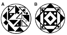
Figure 1.1. Holism. The significance of spatial structure and relationships between components in a given system, e.g., landscape elements in a given landscape. B is not the mere sum of the components in A due to different interactions across system components, changed by an alteration on the spatial organization of the elements, i.e., structure. With permission from Bòlos 1992
Additionally “systems thinking is a method of scientific enquiry that allows one to understand and investigate complex realities” such as landscapes (Tress and Tress 2001, 149). Holistic thinking “provides the basis for studying certain wholes or systems, without knowing all the details of its internal functions” (Zonneveld 1988, 8).
The modelling approach used to study the dynamic interactions between landscape spatial structure and functions is similar to those so-called black box models, which are useful to model complex systems. In these we know both the inputs (change in structure, e.g., shape of a patch), and the outputs (change in a certain function, e.g., increase in movement of a certain species of interest, or an ecological process), but we do not comprehend entirely the mechanisms of this relationship (what is behind what happens between input and output) (Figure 1.2).
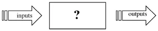
Figure 1.2. “Black box” modelling approach. Both input and output are known, but often the mechanisms or the causal relationships that operate between inputs and outputs are not well understood.
Isolation is a landscape characteristic emerging from a given landscape structure, measurable by particular landscape metrics. Ecological significance of isolation of a certain patch only has meaning if the patch is considered within its landscape context. For example, what is the relationship of the patch to other patches in its neighborhood? (Figure 1.3).
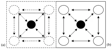
Figure 1.3. The concept of isolation is understood differently at the patch and landscape (context). The box represents the focus of the analysis, i.e., our landscape; circles represent landscape spatial elements, and the arrows represent landscape flows between elements. Solid lines represent elements and flows that are being considered, dashed lines represent those that are disregarded. Note that in the left diagram (a) the focus is on the central patch. Landscape context, including all other patches around it and the relationships between these, is ignored. Thus the ecological significance of the isolation of the central patch in (a) only makes sense if we consider what...
Table of contents
- About Island Press
- Title Page
- Copyright Page
- Dedication
- Table of Contents
- Foreword
- Preface - The Need for Sustainable Planning
- Acknowledgments
- 1 - Landscape Ecology
- 2 - Planning the Landscape
- 3 - The Selected Set of Landscape Metrics
- 4 - Applications of Landscape Metrics in Planning and Management
- 5 - Recommendations on the Use of Landscape Metrics to Support the Planning of Sustainable Landscapes
- Glossary
- References
- Author Bios
- Index
- Island Press Board of Directors
Frequently asked questions
Yes, you can cancel anytime from the Subscription tab in your account settings on the Perlego website. Your subscription will stay active until the end of your current billing period. Learn how to cancel your subscription
No, books cannot be downloaded as external files, such as PDFs, for use outside of Perlego. However, you can download books within the Perlego app for offline reading on mobile or tablet. Learn how to download books offline
Perlego offers two plans: Essential and Complete
- Essential is ideal for learners and professionals who enjoy exploring a wide range of subjects. Access the Essential Library with 800,000+ trusted titles and best-sellers across business, personal growth, and the humanities. Includes unlimited reading time and Standard Read Aloud voice.
- Complete: Perfect for advanced learners and researchers needing full, unrestricted access. Unlock 1.4M+ books across hundreds of subjects, including academic and specialized titles. The Complete Plan also includes advanced features like Premium Read Aloud and Research Assistant.
We are an online textbook subscription service, where you can get access to an entire online library for less than the price of a single book per month. With over 1 million books across 990+ topics, we’ve got you covered! Learn about our mission
Look out for the read-aloud symbol on your next book to see if you can listen to it. The read-aloud tool reads text aloud for you, highlighting the text as it is being read. You can pause it, speed it up and slow it down. Learn more about Read Aloud
Yes! You can use the Perlego app on both iOS and Android devices to read anytime, anywhere — even offline. Perfect for commutes or when you’re on the go.
Please note we cannot support devices running on iOS 13 and Android 7 or earlier. Learn more about using the app
Please note we cannot support devices running on iOS 13 and Android 7 or earlier. Learn more about using the app
Yes, you can access Measuring Landscapes by Andre Botequilha Leitao,Joseph Miller,Jack Ahern,Kevin McGarigal in PDF and/or ePUB format, as well as other popular books in Architecture & Architecture General. We have over one million books available in our catalogue for you to explore.