This book explores the notion of mapping in architectural discourse. First locating, positioning and theorizing mapping, it then makes explicit the relationship between research and design in architecture through cartography and spatial analysis.
It proposes three distinct modalities: tool, operation and concept, showing how these methods lead to discursive aspects of architectural work and highlighting mapping as an instrument in developing architectural form. It emphasizes the importance of place and time as fundamental terms with which to understand the role of mapping. An investigation into architectural discourse, this book will appeal to academics and researchers within the discipline with a particular interest in theory, history and cartography.
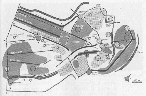
With the publication of The Image of the City1 in 1960, urban planner and scholar Kevin Lynch intended to make a set of planning tools for urban design available to a larger public of scholars, academics, practitioners and even non-professionals.2 In the book, Lynch explicated how an individual’s experience of the city is the result of several navigations through the city over time, which is subsequently spatially organized in the individual’s mind. The accumulated knowledge of these navigational experiences of the city is, furthermore, formalized into a ‘mental map’.3 Investigating these mental maps had enabled Lynch to distinguish the underlying principles of the spatial experience of the city. The Image of the City publication actually came out of a larger research project, financed by the Rockefeller Foundation and titled ‘The Perceptual Form of the City’, which Lynch had started in 1954 together with Gyorgy Kepes.4The Image of the City allowed Lynch to clarify the spatial entities that constitute the primary elements with which one moves and spatially orients oneself in a city. These five spatial elements were termed ‘paths’, ‘edges’, ‘districts’, ‘nodes’ and ‘landmarks’ by Lynch,5 and they formed ‘simply the raw material of the environmental image at the city scale’6 (Figure 1.1). Lynch’s insistence on the importance of analyzing mental maps with the specific purpose of understanding the individual’s experience of the city has since qhad some considerable following, and this field of expertise has become more generally known as ‘cognitive mapping’.
Figure 1.1 Kevin Lynch, the ‘visual form of Boston as seen in the field’, indicating the position and frequency intensity of paths, edges, nodes, districts and landmarks in the city. Map from: The Image of the City, 1960.
With respect to clarifying the emergence and subsequent significations of cognitive mapping, substantial work has been done by scholars Rogers M. Downs and David Stea and by Jörg Seifert. Downs and Stea have extensively discussed the variety of discursive applications of cognitive mapping itself, while Siefert provided for an overview of the mental-map discourse by discussing the consequential positions that were taken after Lynch’s publication.7 Downs and Stea located the historical origin of environmental cognitive mapping in the 1954 doctoral dissertation by Terence Lee, a British psychologist, and in much earlier work in geography8 and psychology, namely by Binet (1894), Claparède (1903), Gulliver (1908) and Trowbridge (1913).9 According to Downs and Stea, cognitive mapping ‘involves the use of a set of operations, which translate information taken from the spatial environment into an organized representation so that, at a later date, this representation will be useful to us’.10 A cognitive map is thus a personal, ordered representation of the built environment and is therefore indicative of the way we spatially understand the environments in which our day-to-day activities take place.
By emphasizing the clarity of the visual quality of the city image, Lynch’s argument in The Image of the City culminated in a plea for the design of healthy, clear and understandable spaces in city planning. Lynch showed how urban forms and urban planning do not necessarily have to be based on geometrical principles of composition, nor on apparent needs that are derived from societal developments, nor even be the result of a political decision-making process11 but could be based on the visual aspect of spatial experience, what would later result in the clearer statement on the importance of the perceptual form of the city. Lynch’s mental maps were translations of these visual images into cartographic representations, with, if one intends to remain precise, an emphasis on the image rather than the map as the core of his research. Seifert has confirmed this by pointing out that Lynch emphasized the term ‘image-ability’ more and more, since he had come to realize that orientation would not be able to cover the entire spectrum of the image of the city an individual would have in her/his mind.12 It should be additionally understood that, by focusing on American cities, Lynch’s mental maps were mainly addressing spatial issues, rather than formal issues, since formal composition is hardly relevant within the context of the American city.13
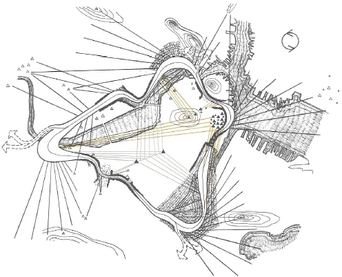
Also in The View from the Road,14 Lynch’s co-authored investigative work on the spatial experience of the motorway and car travel, particular attention is given to the use of maps in attempting to achieve the objective of shaping the highway’s visual experience.15 Here, orientation is ‘the general image of the road and the landscape that develops in the mind, partly as a result of what is presently visible, partly as a result of the memory of past experience’.16 The authors conclude that the basic components of the highway experience are to be found in four aspects, namely, the details of the roadscape itself, the experience of motion in space, spatial orientation and the significance of the surrounding landscape17 (Figure 1.2). Contrary to The Image of the City project, in which the maps were only used as investigative tools, the emphasis in this work is simultaneously placed on the technique of recording, analyzing and expressing the road’s ‘visual sequences’18 and on ‘methods of design’,19 resulting in a well-developed and clearly explained notation system that is employed and formalized in the maps. The related, highly specific notation technique, which was influenced by the work of Philip Thiel, is intended precisely to enable both the analysis and the design of the road’s experience.20
In hindsight, Lynch’s investigations constituted one of the first times, in the history of architectural thinking at least, when methods of mapping had been made the primary means to make immanent spatial conditions ‘accessible’ for (urban) design. By bringing forward the role information plays in the way one navigates and orients oneself in urban spaces, information that comes out of one’s surroundings and is processed by the individual into a mental image,21 Lynch was able to clarify how the experience of urban spaces could be improved by translating the description of contemporary city dweller’s mental images into (mental) maps. However, this descriptive aspect of Lynch’s mappings also constitutes one of the more fundamental points of critique that his studies have since received. The fact that the persons interviewed in the investigations verbally described these mental maps, after which the researchers drew them, had significantly limited the outcome of the investigations by imposing a notation system a-priori.22 As Downs and Stea have stated: ‘Above all, we should avoid getting “locked” into a form of thinking through which we, as investigators, force a subject to “produce” a cartographic cognitive map and which we then “verify” against an objective cartographic map’.23 Still, in its deployment of cartographic techniques and procedures in the investigation of urban space, Lynch’s analytical work has remained extremely influential and even ground-breaking to such an extent that his The Image of the City is nowadays considered a seminal work.24 Already in the late 1970s, Downs and Stea had described Lynch’s 1960 influential study of urban navigation as ‘still the most cited and widely read work on cognitive mapping’,25 and its influence, as well as its appeal and scientific importance, has hardly diminished since. Both The Image of the City and The View from the Road have been, even if the first seems nowadays somewhat outdated, extremely clear in explaining how orientation in the city works and how these orientation processes can be made insightful through the use of maps.
Figure 1.2 Donald Appleyard, Kevin Lynch and John R. Myer, the ‘space-motion and view diagram, counterclockwise travel’ of the Boston Expressway, depicting issues of the roadscape itself, senses of motion, landscape features and senses of orientation. Map from: The View from the Road, 1965.
This crediting of Lynch26 does not mean that cartographic techniques in spatial analysis had not been used previously. Several projects and works can and will be mentioned in the course of this book, in which specific cartographic techniques were either used or developed to enable the registration/preparation of architectural form and/or the interpretation of urban spatial configurations or processes. Lynch, however, was one of the first in architectural discourse to attempt to methodically analyze ‘visual form at the urban scale’27 by using maps as the primary research tool. Since then, in general at least, the use of cartographic techniques, the reference to maps and the use of ‘spatial mapping’ as a critical praxis has taken a significant advancement in a vast array of disciplines, including architecture, both in terms of significance and in terms of implementation. Especially the past two decades have shown the enormous impact of technological inventions of navigational instruments (such as GPS or CIS) and the similarly influential impact of simple navigational tools (such as TomTom and Google Earth). These developments were furthe...
Table of contents
Cover
Half Title Page
Series Page
Title Page
Copyright Page
Contents
List of figures
Acknowledgements
Introduction
Part 1 The emergent in mapping
Part 2 Mapping towards architectural construct
Epilogue
Index
Frequently asked questions
Yes, you can cancel anytime from the Subscription tab in your account settings on the Perlego website. Your subscription will stay active until the end of your current billing period. Learn how to cancel your subscription
No, books cannot be downloaded as external files, such as PDFs, for use outside of Perlego. However, you can download books within the Perlego app for offline reading on mobile or tablet. Learn how to download books offline
Perlego offers two plans: Essential and Complete
Essential is ideal for learners and professionals who enjoy exploring a wide range of subjects. Access the Essential Library with 800,000+ trusted titles and best-sellers across business, personal growth, and the humanities. Includes unlimited reading time and Standard Read Aloud voice.
Complete: Perfect for advanced learners and researchers needing full, unrestricted access. Unlock 1.4M+ books across hundreds of subjects, including academic and specialized titles. The Complete Plan also includes advanced features like Premium Read Aloud and Research Assistant.
Both plans are available with monthly, semester, or annual billing cycles.
We are an online textbook subscription service, where you can get access to an entire online library for less than the price of a single book per month. With over 1 million books across 990+ topics, we’ve got you covered! Learn about our mission
Look out for the read-aloud symbol on your next book to see if you can listen to it. The read-aloud tool reads text aloud for you, highlighting the text as it is being read. You can pause it, speed it up and slow it down. Learn more about Read Aloud
Yes! You can use the Perlego app on both iOS and Android devices to read anytime, anywhere — even offline. Perfect for commutes or when you’re on the go. Please note we cannot support devices running on iOS 13 and Android 7 or earlier. Learn more about using the app
Yes, you can access Mapping in Architectural Discourse by Marc Schoonderbeek in PDF and/or ePUB format, as well as other popular books in Architecture & Architecture Criticism. We have over one million books available in our catalogue for you to explore.