![]()
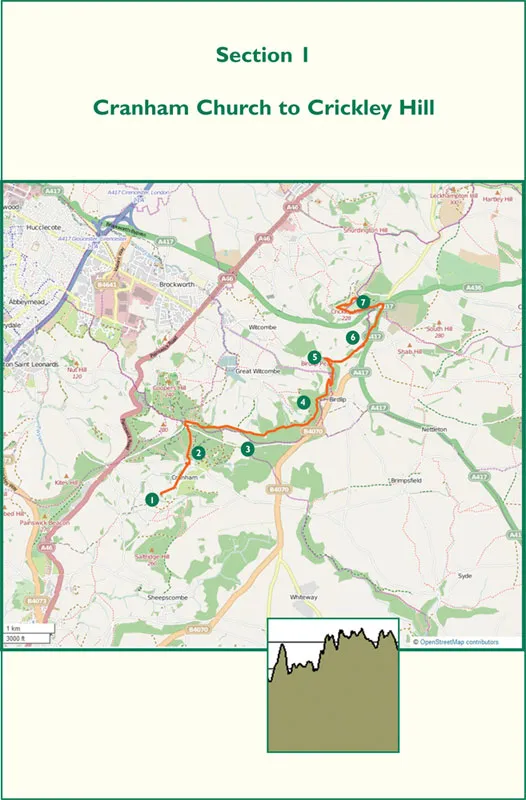
Section 1
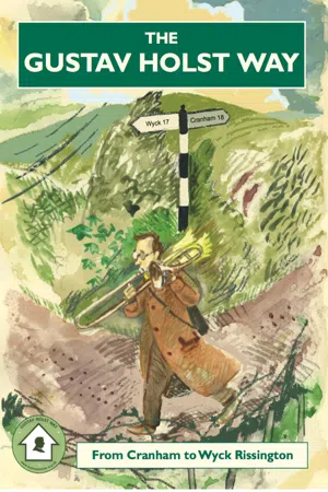
Cranham Church (grid ref 891124) to Crickley Hill
Distance: 5.7 miles/9.2 km
Grading: Moderate/strenuous
Time: 3 hours
From lofty Cranham village through extensive beech woods to pass along the Cotswold Edge, emerging on open, high ground with magnificent views, ending at Crickley Hill Country Park.
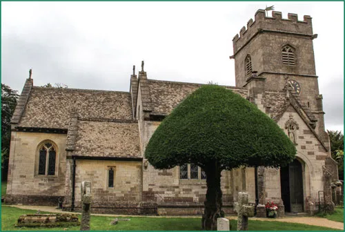
The starting point of the Gustav Holst Way is the 14th century church of St James the Great (1) on the south-west side of Cranham: a place of fond family memories for the budding composer. Holst’s mother Clara played the harmonium and arranged the flowers at the church, and her highly musical son would surely have taken to the keyboard on some of his regular visits. Set on an escarpment on a western fold of the Cotswolds, Cranham is almost completely encircled by ancient beech woods. Clinging to the hillside, its upper reaches extend as high as 923ft (281m): the village in midwinter can be bleak indeed, and if you plan to tackle this opening section any time between November and March, you would be wise to check the local weather forecast before setting off.
St James the Great Church Cranham
In common with many churches in the area, St James boasts a colourful array of kneelers embroidered by the parishioners, one of which is dedicated to Holst’s hymn and embellished with snowflakes and a musical notation of his melody. The church briefly found itself in the glare of the media in the summer of 2011, when the pop star Lily Allen was married there.
Outside the church, a distinctive green roundel on the noticeboard indicates the ‘official’ start of the Holst Way. The composer’s bespectacled silhouette on posts (and stickers on lamp-posts) will be your constant companion over the next 35 miles.
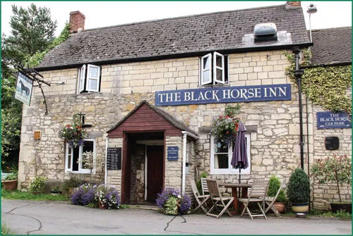
Follow the road until you pass the primary school on the right. To the left, a gently sloping sward of grass leads you downhill to a track and a wooden swing-gate giving access to Cranham Common. A little further on is the ivycovered Black Horse Inn.
Turn left at the pub, dropping towards the lower part of the village. After 80m you pass Midwinter Cottage (2), its name marked on a white wroughtiron gate.
Continue downhill to the lower part of the village and turn right onto the main street. Walk about 50m uphill and turn left onto the signposted footpath, which crosses a stream and enters Buckholt Wood. A wider path intersects with this path, but continue straight ahead on a gradually steepening gradient. Yellow directional arrows marked on tree trunks point the way up the wooded slope, which can be exceptionally muddy in wet conditions. Keep going for about 400m until you arrive at a T-junction. Turn left, and scramble up the steeper and narrower path that eventually emerges from the wood at a road, opposite Woodland House. Buckholt Wood is one of two or three sections of the walk where you can easily lose your way. If this happens, keep going up the slope and regain your bearings at the road.
Cross the road at Woodland House and turn left, passing a larger property called ‘The Buckholt’ (3). This house has close associations with the Holst family (see page 12). At the end of the garden wall, turn right off the road and take the right of two signed footpaths. After 150m, turn right onto a forest track which makes a gentle descent through the trees until it meets the Cotswold Way, the 102-mile National Trail between Bath Abbey and Chipping Campden. Turn right onto this much wider, well-marked path which follows the line of the Cotswold edge as it passes through Witcombe Wood. Shortly after a left turn at a T-junction (clearly marked by roundels) the path crosses the road just below Birdlip village (4) and continues uphill through the trees for about 400m. At another T-junction, a fingerpost indicates the continuation of the route to the right, but a 200m diversion left to ‘The Peak’ (5) will be rewarded with panoramic views over the scarp edge to the Severn Vale. Make sure you keep to the left (of several paths) on your return to the fingerpost.
From here, the Holst/Cotswold Way zig-zags as it nears the edge of the wood and takes a left turn through a gate into an open field: welcome daylight after the best part of an hour’s walking beneath the shady canopy of beech trees. Keep to the left of the field, pass through another gate, and turn right up a flight of steps shortly after a solitary white house appears in the distance. A little further on is the Barrow Wake viewpoint (6), from where the Malvern Hills are usually visible about 20 miles away. Shortly afterwards, the path runs alongside the A417, dropping down towards the Air Balloon public house beside a very busy roundabout. On the far side, pass through a gate into some open National Trust land signposted ‘The Scrubs’ that is part of Crickley Hill Country Park, a Site of Special Scientific Interest (SSSI) containing an Iron Age hill-fort and other, earlier, ancient settlements dating from 3500BC and finally abandoned during the Dark Ages, around 500AD. Follow the Cotswold Way signs through the park to the visitor centre (7), which has some interesting displays explaining the development of the site, toilets, and offers a limited selection of snacks and refreshments between 1 April and 30 September.
When did the Great War end?
The gateway to Cranham church was built in thanksgiving for victory in the Great War. Dated 1914-19, it commemorates ‘seven of Cranham and five of Prinknash’ who died in the conflict. Why 1919? Although an Armistice was agreed between the Allies and Germany in November 1918, peace was not officially declared between Britain and Germany until the Treaty of Versailles the following June, and it was as late as September 1919 before a peace accord was finally agreed between the Allies and Austria. Many Great War memorials around the country (including the one on the Promenade in Cheltenham) reflect this lengthy delay in bringing ‘the war to end all wars’ to a conclusion.
Midwinter Cottage
While staying at the cottage in 1904, Holst composed a setting for ‘In the Bleak Midwinter’ to a poem by Christina Rossetti that had been published 32 years earlier. Christina was the sister and muse of the Pre-Raphaelite Brotherhood leader, Dante Gabriel Rossetti. She knew Gloucestershire well, often visiting her uncle, Henry Polydore, who lived in Cheltenham. The hymn, known as Cranham, first appeared in the English Hymnal of 1906 and, although other composers (including Benjamin Britten and Harold Edwin Darke) have put Rossetti’s words to music, Holst’s plaintive melody remains among the most evocative of all English Christmas carols.
The Buckholt
Much extended over the years, this house was originally known as Buckholt Cottage and belonged to Holst’s maternal great-grandfather, David Whatley, whose daughter Mary was born in 1806. Mary married Samuel Lediard at the age of 20, and one of their nine children was Clara, Holst’s mother. After her husband died suddenly of typhoid fever in 1852, Mary had to look after the large family alone, and lived with them in Buckholt Cottage for some years before moving to No 4 Pittville Terrace in Cheltenham to enable her to send Clara to Cheltenham Ladies’ College, and her son Henry to Cheltenham College. Clara married Adolphus von Holst, and their son Gustav was born in the house in 1874. Grandmother Mary ended her days at Cowley, near Oxford, where she died in 1895.
![]()
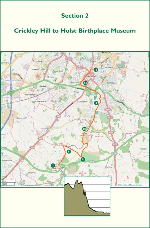
Section 2
Crickley Hill (grid ref 930164) to Holst Birthplace Museum
Distance: 7.3 miles/11.5km
Grading: Moderate
Time: 3 hours
From Crickley Hill country park along the Cotswold Edge to Leckhampton Hill, passing Devil’s Chimney before descending on an old quarry incline to Cheltenham and finishing at Holst’s birthplace in Pittville.
Turning right out of the Crickley Hill visitor centre (7), join the Cotswold Way. After 100m, turn left through a gap in the fence and immediately right through a gate. After the best part of a mile turn right into Greenway Lane, which is bordered by beech trees (some more than 250 years old) and leads to a crossroads. Carry straight on along a minor road which passes the National Star College (8) to the right.
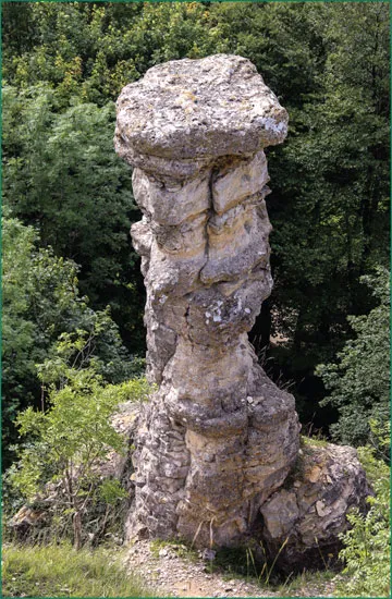
Continue along the lane for approximately 200m, and turn left on to a track signposted ‘Cotswold Way, Leckhampton Hill 1½ miles, Restricted Byway’. The track makes a steady ascent past Cotswold Hills Golf Club, skirting a large field to reach a T-junction at Hartley Lane (9). Turn left and follow the lane for 300m before turning right at the Cotswold Way sign on to a narrow track which climbs through trees and shrubs above Wagoner’s Quarry car park on the left, leading to a swathe of open grassland on the edge of the escarpment. Much of t...