A local historian explores the rich history of this rugged Canadian coastline with fascinating research and twenty-five historical photos.
The beautiful harbours of Nova Scotia take many forms. Some are broad and studded with islands, while others are long inlets carved out by glaciers. Prized by the indigenous Mi'kmaq people as well as European settlers, they contain fascinating tales from the Age of Sail the American Revolution, the Golden Age of Piracy, and much more.
Featuring profiles of more than fifty harbours—from the Bedford Basin to Shelburne Harbour to Cobequid Bay, Louisbourg, and Canso—
Nova Scotia's Historic Harbours explores each harbour's historical significance. Local historian Joan Dawson shows how these communities have been shaped by the sea, and how Nova Scotia's growth has been driven by its wealth of harbours.
- 293 pages
- English
- ePUB (mobile friendly)
- Available on iOS & Android
eBook - ePub
About this book
Trusted by 375,005 students
Access to over 1.5 million titles for a fair monthly price.
Study more efficiently using our study tools.
Information
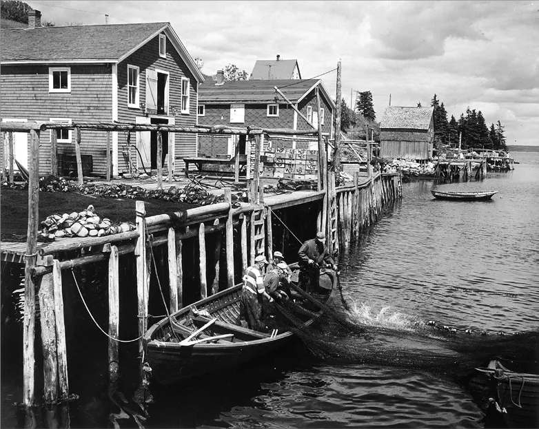
South Shore
St. Margarets Bay
Peggys Cove
This exploration of Nova Scotia’s harbours continues by following the Lighthouse Route, leading out of Halifax towards St. Margarets Bay and the village of Peggys Cove. Tucked among granite rocks scraped bare by glaciers, this picturesque fishing village lies at the eastern entrance to the bay, which extends between the Chebucto and Aspotogan Peninsulas. Of all the beautiful, rocky inlets within a short drive of Halifax, Peggys Cove is the best-known.
The much-photographed lighthouse perched on granite rocks, and the fishing boats in its enclosed harbour make Peggys Cove a popular destination. The cove’s earliest residents would be astonished by the busloads of cruise-ship passengers who are disgorged onto the parking lots to swarm over the rocks during summer and early fall. Once known as Eastern Point Harbour or Peggs Harbour, the origin of the name is shrouded in mystery; some accounts link it to St. Margarets Bay (“Peggy” being a nickname for Margaret), others to the wife of an early settler. A more romantic story is that a woman named Peggy was the sole survivor of a shipwreck, and she lived in the cove and married a local resident.
By the early twentieth century the population of the village had grown to about three hundred, with houses scattered on the rocky ground on both sides of the harbour. The residents were mostly fishers, or employed in fish processing. In addition to the lobster cannery, there were flakes for drying salt cod. There was also a school and a general store. St John’s Anglican Church, built in the 1890s, is still in use.
The iconic lighthouse was built in 1868, to guide shipping safely into St. Margarets Bay. For many years it was operated as a post office, and visitors enjoyed sending postcards with the distinctive postmark that included the lighthouse image. Artist William deGarthe made his summer home in the cove and began a career of portraying scenes from village life, in particular the lives of fishers in the twentieth century. He also carved the Fishermen’s Memorial Monument on the rock face near his house, honouring the local families. This ten-year project was incomplete at the time of his death, but was completed by another artist who had worked with him during the first five years.
Although the permanent population of the village has shrunk to about thirty, there are still full-time fishers using the wharves. The Peggy’s Cove Commission oversees the preservation of the village’s character by careful regulation, so visitors today can see the harbour and the cluster of homes around it much as they would have been one hundred years ago.
Little Harbours on the Bay
The journey continues around the bay past other scenic harbours. Many centuries ago, these inlets were havens for transient European fishers. Settlement began in the area in the latter part of the eighteenth century with the Dauphinees and the Boutiliers, whose roots were in Montbéliard, France. They came from Lunenburg to a cove on the eastern side of the bay with a wide view across the water that became known as French Village. Families spread out from there, leaving their names in the fishing villages around the bay. In 1794, James Frederick Boutilier and his cousin John Coulaw Boutilier bought land at what came to be known as Boutiliers Point, naming the nearby harbour of Cowlow Cove. Other family members settled on the east side of the bay, at Boutiliers Cove.
Brothers John and Frederick Dauphinee moved across the bay to the harbour that is now Hubbards, giving their name to Dauphinees Beach and Dauphinees Point. The village that grew up there was called Hibberts Cove, said to be named after Hibbert Dauphinee, and later known as Hubbards. Its residents caught and processed fish, and cut lumber. Today, Hubbards is a growing community that welcomes visitors, especially for festive lobster suppers.
Fishing was the chief occupation of all the villages around the bay for many generations but in the twentieth century, the younger generations started to move away to find work in cities. Several older homes became summer cottages for people from Halifax, who might come and stay for all of June and July. There were train stations serving French Village, St. Margarets Bay, Ingramport, and Hubbards, so it was not uncommon for men to commute daily, or perhaps just on Friday and Monday. Eventually cars replaced trains, and today an increasing number of people live at the head of the bay and work in Halifax. Fishing boats still work out of small harbours from Northwest Cove to Peggys Cove, and lobster has replaced cod and mackerel as the most important catch.
On the opposite side of the bay, Northwest Cove is also a long-established fishing harbour. Less well-known than Peggys Cove, it has a similar history of settlement. It shared with Peggys Cove the effects of a major disaster that took place in St. Margarets Bay in 1998. Just after 10:30 p.m. on September 2, when most of the residents had gone to bed, they were startled by a loud boom out on the water, followed by the sound of sirens. A passenger plane, Swissair 111, travelling from New York to Geneva, was in trouble. The pilot had hoped to make an emergency landing in Halifax, but the plane came down in the water at the entrance to the bay.
Word quickly spread that a plane had crashed and local fishers from all around the bay, who were accustomed to looking out for their colleagues at sea, quickly set out in their boats in a vain search for survivors. They were unprepared for the devastating scene of wreckage they found. In the following days and weeks, residents from all around the bay were involved in supporting the teams whose gruesome task was the retrieval of the remains of the plane and its 229 passengers. They were also there to help the relatives of the victims who flew in from many parts of the world. The disaster had a profound emotional effect on many people in the communities around St. Margarets Bay.
Stark granite memorials have been erected on each side of the entrance to the bay, looking towards the spot where the tragedy took place. Today, visitors to these quiet places recall the greatest disaster in St. Margarets Bay’s history.
Mahone Bay
The scenic route continues around Mahone Bay, between the Aspotogan Peninsula and Lunenburg. There are numerous islands in this bay—said to be as many as there are days in the year, although this is a generous estimate. The name Mahone may come from the French word mahonne, referring to a type of boat apparently favoured by pirates who lurked among the islands to attack passing vessels. For hundreds of years there were Mi’kmaw communities on islands and inlets all along the coast, and today there is a reserve at Gold River, part of the Acadia First Nation.
Today, there are small communities around the bay, the two largest of which are Chester and the town of Mahone Bay.
Chester
Chester is a charming little community blessed with two harbours. What is known locally as “the peninsula” is in fact an island, joined to the village by a narrow causeway that leads to some of the most expensive properties in the area.
The town plan was laid out by Jonathan Prescott in about 1760 for settlers from New England. He combined his skills as a surveyor and a surgeon and became captain of the Chester militia. Prescott and another man, Benjamin Bridge, were already established in the area when the first New Englanders arrived.
The newcomers were welcomed, both by these residents and by the local Mi’kmaq, who danced for their entertainment on the first evening, bringing food and items to sell. A journal kept by the Rev. John Seccombe, one of the community leaders, tells of a Mi’kmaw woman bringing five salmon and eight salmon trout in a birchbark canoe. “One of the salmon weighed twenty-two pounds and one dozen of the trout weighed fourteen pounds.” Indigenous hunters continued to supply the new residents with partridge, moose, bear, and other items. Mi’kmaw women brought sealskins for sale, and on one occasion traded mink pelts and a large bearskin for a quart of wine.
By 1763, thirty families were living in Chester. They cleared land for homes and gardens, but the soil was unsuitable for extensive agriculture, and they made their living by fishing and lumbering. Soon, fifty families had settled, and two sawmills were operating. Fishers based in Chester’s harbours sold cod, salmon, and mackerel. The fishery, boat building, lumbering, and the export of forest products were the main occupations for many years.
During the American Revolution, privateering took place around Chester and elsewhere in the bay. In 1776, a Chester schooner, the Patty, was captured by an American vessel and taken away with a local boy on board. In 1782, three American privateers entered the harbour and fired at the town. The militia’s guns were unable to deter them and the crews landed, ostensibly seeking permission to bury their dead. Jonathan Prescott became suspicious and invited the schooner captains to his house to discuss arrangements. While they were there, Prescott’s son knocked on the door, asking loudly where he might billet a hundred Lunenburg militiamen. He was told to put them in Houghton’s barn, ready for an assault in the morning. The ruse was effective, and the privateers, thinking they would be outnumbered, made a discreet withdrawal.
More privateering occurred during the War of 1812, and in 1813 the American privateer Young Teazer was pursued into Mahone Bay having escaped from an encounter with British ships at the mouth of Halifax Harbour. After a long chase among the islands, the vessel ran aground on Quaker Island, off Chester Harbour. She was fired on by guns on shore, and the captain realized that the game was up. One of the ship’s officers, a deserter from the British navy, knew that he would be hanged if he was caught. To avoid capture, he set fire to the powder magazine, and the vessel exploded in a sheet of flame. He and many of his shipmates were killed, and of the eight survivors, most were severely injured.
The story does not end there. Local historian Mather Byles DesBrisay wrote, “A superstition has arisen amongst the inhabitants of the islands in Chester Bay, that the Teazer, like the Flying Dutchman of old, supernaturally visits the waters in which she met her fate, and that the ‘Teazer light’ has long been a matter of alarm to many while passing over Chester Bay.” Tales of the fiery ghost ship are still told in local communities.
A grand regatta was held in September 1856, attended by over three thousand people. Races were held for various types o...
Table of contents
- Preface
- Introduction
- Bays and Harbours
- Comings and Goings
- The Fishery
- Shipbuilding
- Halifax’s Harbours
- South Shore
- Acadian Shore
- Bay of Fundy
- Northumberland Shore
- Cape Breton Island
- Eastern Shore
- Afterword
- Acknowledgements
- Bibliography
Frequently asked questions
Yes, you can cancel anytime from the Subscription tab in your account settings on the Perlego website. Your subscription will stay active until the end of your current billing period. Learn how to cancel your subscription
No, books cannot be downloaded as external files, such as PDFs, for use outside of Perlego. However, you can download books within the Perlego app for offline reading on mobile or tablet. Learn how to download books offline
Perlego offers two plans: Essential and Complete
- Essential is ideal for learners and professionals who enjoy exploring a wide range of subjects. Access the Essential Library with 800,000+ trusted titles and best-sellers across business, personal growth, and the humanities. Includes unlimited reading time and Standard Read Aloud voice.
- Complete: Perfect for advanced learners and researchers needing full, unrestricted access. Unlock 1.5M+ books across hundreds of subjects, including academic and specialized titles. The Complete Plan also includes advanced features like Premium Read Aloud and Research Assistant.
We are an online textbook subscription service, where you can get access to an entire online library for less than the price of a single book per month. With over 1.5 million books across 990+ topics, we’ve got you covered! Learn about our mission
Look out for the read-aloud symbol on your next book to see if you can listen to it. The read-aloud tool reads text aloud for you, highlighting the text as it is being read. You can pause it, speed it up and slow it down. Learn more about Read Aloud
Yes! You can use the Perlego app on both iOS and Android devices to read anytime, anywhere — even offline. Perfect for commutes or when you’re on the go.
Please note we cannot support devices running on iOS 13 and Android 7 or earlier. Learn more about using the app
Please note we cannot support devices running on iOS 13 and Android 7 or earlier. Learn more about using the app
Yes, you can access Nova Scotia's Historic Harbours by Joan Dawson in PDF and/or ePUB format, as well as other popular books in History & Military & Maritime History. We have over 1.5 million books available in our catalogue for you to explore.