A brisk chronicle of Vancouver, BC, from early days to its emergence as a global metropolis, refracted through the events, characters and communities that have shaped the city.
In Becoming Vancouver award-winning historian Daniel Francis follows the evolution of the city from early habitation by the Musqueam, Squamish and Tsleil-Waututh First Nations, to the area's settlement as a mill town, to the flourishing era speakeasies and brothels during the 1920s, to the years of poverty and protest during the 1930s followed by the long wartime and postwar boom to the city's current status as real-estate investment choice of the global super-rich. Tracing decades of transformation, immigration and economic development, Francis examines the events and characters that have defined the city's geography, economy and politics.
Francis enlivens his text with rich characterizations of the people who shaped Vancouver: determined Chief Joe Capilano, who in 1906 took a delegation to England to appeal directly to King Edward VII for better treatment of Indigenous peoples; brilliant and successful Won Alexander Cumyow, the first recorded person of Chinese descent born in Canada; L.D. Taylor, irrepressible ex-Chicagoan who still holds the record as the city's longest-serving mayor; and tireless activist Helena Gutteridge, Vancouver's first woman councillor.
Vancouver has been called a city without a history, partly because of its youth but also because of the way it seems to change so quickly. Newcomers to the city, arriving by the thousands every year, find few physical reminders of what was before, making a work like Becoming Vancouver so essential.
Trusted by 375,005 students
Access to over 1.5 million titles for a fair monthly price.
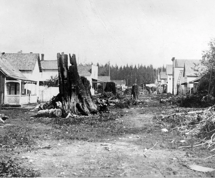
Water Street was the core of old Gastown and Vancouver’s “Main Street” when the city was incorporated in 1886. City of Vancouver Archives, AM54-S4-: Str P8
Chapter One Birth, and Rebirth
Depending on one’s point of view, the “founder” of the city of Vancouver might be a combative sawmill manager, a voluble saloon keeper or an arrogant railway tycoon. The sawmill owner was Edward Stamp, a sea captain from Northumberland who, impressed by what appeared to be the limitless abundance of the coastal forest, launched the British Columbia and Vancouver Island Spar, Lumber and Saw Mill Company on the south shore of Burrard Inlet in 1865. More succinctly known as Hastings Mill, this enterprise provided the economic lifeblood for the tiny community of loggers and drinkers that eventually became the city.
The saloon keeper was John Deighton, known to his customers as Gassy Jack for his tendency to run off at the mouth. “He was a man without education,” remarked the historian F.W. Howay, “but that did not prevent him from airing his views on any and every subject . . .”17 Deighton arrived by canoe from New Westminster in September 1867, washing up not far from Stamp’s mill with his young Squamish wife, Quahail-ya, a barrel of whiskey and a primitive business plan. Offering free drinks to anyone who would help him, he soon had his Globe House saloon up and running, serving the thirsty millhands. Gastown, the jerry-built settlement that grew up around Deighton’s establishment, was the original core of what emerged as downtown Vancouver.
At the other end of the social spectrum to Gassy Jack was the railway tycoon William Cornelius Van Horne, plump, prosperous and ever so much the man in charge. It was Van Horne, the general manager of the Canadian Pacific Railway, who selected Vancouver as the western terminus for his transcontinental line—he even chose its name—thereby ensuring the city’s future as Canada’s entrepôt on the Pacific and gateway to the great world beyond. Any one of this disparate trio might reasonably lay claim to being the “founding father” of Vancouver.
Unless, of course, you consider August Jack’s people, the Indigenous residents, who, as the 1933 map made clear, populated the inlet in significant numbers long before the arrival of outsiders. These Coast Salish people—known today as the Musqueam, Squamish and Tsleil-Waututh First Nations—used the waters of the Fraser River and Burrard Inlet to fish, hunt seals and waterfowl, and gather shellfish. In the dense forest and open marshes that covered the site of the future city, they tracked deer, bear and smaller animals, and gathered fruits and edible plants. The temperate climate nurtured the tall trees that provided the wood they used to manufacture their lodges, canoes, utensils and monumental art. Again, as the map made clear, they named all the major landmarks, from Siwash Rock (Slah-kay-ulsh) to Kitsilano Beach (Skwayoos) to Point Grey (Ulksen) to Brockton Point (Paapee-ak), and they inhabited several villages and seasonal camps within what are now the city limits.
When the twenty-three-year-old Spanish navigator José María Narváez appeared off Point Grey in the summer of 1791, several canoes of Musqueam came out from a village at the mouth of the Fraser River to trade. Narváez’s expedition, which consisted of forty-one officers and crew aboard the 11-metre sloop Santa Saturnina and an accompanying longboat, was the first European venture into what the Spanish called the Gran Canal de Nuestra Señora del Rosario la Marinera, what came to be known as the Strait of Georgia or, more recently, the Salish Sea. The Gran Canal held out the possibility that it was the entrance to the fabled Northwest Passage—the Spanish called it the Strait of Anián—connecting the Pacific and Atlantic Oceans across the top of North America. Such a passage, if it existed, would allow Europeans to access more easily the rich trade of the Far East. The Musqueam, knowing as they did the convoluted geography of the coast, could have told Narváez that he was on a wild goose chase, but the language barrier made an exchange of information difficult. The Santa Saturnina continued on its way around the tip of Point Grey into Burrard Inlet, where Narváez anchored briefly off Spanish Banks and then again off the northern shore just outside the narrow entrance to what appeared to be a long channel. The passage looked like it might lead somewhere promising, but Narváez was impatient to continue his investigations of the Gran Canal so he pushed on to the northwest, leaving the future site of Vancouver unexamined.
A year later it was the turn of British mariners. Captain George Vancouver had been sent to the northwest coast to achieve two objectives: first, to negotiate a truce with the Spanish, and second, to settle one way or another whether the rumoured northwest passage actually existed. He had two vessels under his command, the Discovery and the Chatham, with a total of 145 sailors and marines. After a year-long voyage from England, the two ships arrived off northern California in mid-April 1792 to begin their survey of the coastline. Initially Vancouver worked from the ships, but once his vessels entered the Strait of Juan de Fuca, the coast became more complicated, and the meticulous inlet-by-inlet investigation was carried out by the men in longboats. On June 12, two of these boats, one containing Vancouver himself, rowed around Point Grey into Burrard Inlet (named during the visit after Captain Harry Burrard of the Royal Navy). Crossing to the northern shore, they located and entered the narrow opening that Narváez had seen the summer before. The accounts left by the British are not exact, but it seems that the boats were welcomed by two groups of First Nations in canoes. One group were Squamish people from Homulcheson, their village at the mouth of the Capilano River. The other were Musqueam from Xway’xway, a beachfront site known today as Lumberman’s Arch in Stanley Park. Many years later Andy Paull described the scene to Major Matthews as he had heard it from the elders: “Our people threw in greeting before him [Vancouver] clouds of snow white feathers which rose, wafted in the air aimlessly about, then fell like flurries of snow to the water’s surface, and rested there like white rose petals scattered before a bride. It must have been a pretty welcome.”18
As it opened before him, the inner harbour would have seemed an auspicious lead in Vancouver’s search for a passage. To his right the land was low and wooded right down to the shoreline. To his left a wall of forested mountains rose almost from the water’s edge, their flanks broken by a series of rivers and streams tumbling down to the sea. Vancouver must have recognized the value of the dense forest that one day would provide stout timbers for his own navy and fuel an industry to support a community that would take his name. For the moment, however, he had to admit that the inlet was a dead end, as chimerical as all the other nooks and crannies he had investigated. After camping for one night on the south shore opposite the entrance to Indian Arm, the two boats returned through the narrows and continued their survey into Howe Sound and as far north as Jervis Inlet, before heading back to the mother ships, which were waiting in Birch Bay.
By this time it was June 21, and as they neared Point Grey they encountered, much to their surprise, a pair of vessels flying Spanish colours. These were the Sutil, commanded by Dionisio Alcalá-Galiano, and the Mexicana under Cayetano Valdés. The Spanish were back in the Gran Canal conducting their own follow-up of Narváez’s visit. Captain Vancouver boarded the Sutil and shared breakfast with Galiano and his officers. The two commanders agreed to pursue their exploration of the coast together. But before the Europeans set sail for the north, the Spanish sent a pair of boats to assure themselves that Burrard Inlet, which they called Canal de Floridablanca, did indeed lead nowhere. Nine days had passed since Vancouver’s reconnaissance. The Spanish made their way through the First Narrows and as far as the head of the inlet. Unlike the British, they investigated the length of Indian Arm, where they encountered a camp of Tsleil-Waututh people with whom they had a short meeting. Then they retraced their steps and departed the main inlet after recording that the local people called it “Sasamat.”
The world that these European mariners entered in the 1790s was not the same world they would have seen had they arrived even a few years earlier. George Vancouver remarked on the number of deserted villages he and his officers observed. A smallpox epidemic had swept through the southern coast in the 1780s, killing as much as 80 per cent of the population in some areas. (Another epidemic may have followed in about 1800, and subsequent ones came later in the century, culminating in the smallpox outbreak of 1862, which claimed an estimated one-third of the First Nations population of coastal BC.) When August Jack Khahtsahlano told Major Matthews that “about a million” First Nations people once lived in the area, he was estimating—overestimating, actually—the much larger population that had existed before the white man’s diseases took their toll. In Burrard Inlet, for example, the Tsleil-Waututh by some accounts numbered about ten thousand people pre-contact, a total that had plummeted to one hundred individuals by the 1830s. The Squamish suffered a comparable decline.
One of the largest settlements on the future site of Vancouver was an ancient Musqueam village and cemetery on the opposite side of the Point Grey peninsula, on the north arm of the Fraser River. Known to the Musqueam as c̓əsnaʔəm, and to outsiders as the Marpole Midden, or the Great Fraser Midden, it dates back several thousand years, though its presence only became known to archaeologists and historians when a road-building gang “rediscovered” it in 1884. The site contained an extensive shell midden, which, when excavated by archaeologists, revealed stone and bone tools, human and animal remains, and other artifacts. In 1933 it was declared a National Historic Site.
The midden site is located upstream from a village encountered by Simon Fraser when he arrived in early July 1808. Fraser was a Nor’Wester, an employee of the Montreal-based North West Company of fur traders. In their quest for furs the traders had pushed across the continent and were now seeking a navigable route between their interior posts and the Pacific. Thinking that the river (which now bears his name) might offer such a route, Fraser had set off from Fort George (Prince George) to explore it all the way to the sea. According to his own account, when he landed at the Musqueam village he found “but a few old men and women; the others fled into the woods upon our approach.” Fraser was investigating the shed-style plank dwellings occupied by the Musqueam when one of the people who had been showing him around warned him that he should get away before the others returned. “Having spent one hour looking about this place we went to embark,” he recorded in his journal, “when we found the tide had ebbed, and left our canoe on dry land. We had, therefore, to drag it out to the water some distance. The Natives, no doubt seeing our difficulty, assumed courage, and began to make their appearance from every direction […] howling like so many wolves and brandishing their war clubs. At last we got into deep water, and embarked.”19 After continuing downstream to within sight of the open ocean, Fraser decided to turn back and returned up the river to the interior without further hostility. It is possible that the Musqueam were so hostile because word had reached them that days earlier Fraser had stolen a canoe from some First Nations people near the future site of New Westminster. His own canoes were so battered they had become useless, and Fraser may simply have been borrowing a replacement that he meant to return. Whatever the case, it was not encouraging that relations between the Musqueam and outsiders began with a theft.
The Musqueam ranged widely across the peninsula between the river and Burrard Inlet that we now know as Point Grey, which Major Matthews’s map of place names called Ulksen. They made seasonal visits to English Bay, where they had resource sites at Spanish Banks and Jericho, and Stanley Park. And they occupied Xway’xway, the substantial village site at Lumberman’s Arch. In 1888 road builders discovered a large midden of crushed shells covering a 1.6-hectare site at Xway’xway to a depth of up to 2.5 metres. Evidence suggests that Indigenous people occupied the site for thousands of years before contact, and that other sites in what is now the park were also used for gathering food, for spiritual practices and for burying the dead. The territories of the Musqueam, Squamish and Tsleil-Waututh First Nations overlapped each other so that members of the latter two nations also frequented the park and other sites around what is now Vancouver. In the words of the geographer Cole Harris, the Lower Mainland was “a Native place”: an ancient homeland with a long history.20
Following the visits by George Vancouver, the Spanish and Simon Fraser, outsiders did not return to Point Grey and Burrard Inlet for several decades. The Hudson’s Bay Company built Fort Langley in 1827, about 50 kilometres from the mouth of the Fraser, and the coastal people travelled upriver to trade there. The discovery of gold in the gravel bars of the Fraser Canyon brought thousands of prospectors to the interior, an influx that led to the creation of the colony of British Columbia in 1858 and its capital city, Queensborough (New Westminster), located on the north side of the Fraser about 20 kilometres inland from its mouth. But Burrard Inlet was distant from all this activity, off the beaten path for the traders and gold seekers. As a result, outside interest did not refocus on the future site of Vancouver until the end of the 1850s.
In 1859 Captain George Henry Richards, in command of the steam sloop HMSPlumper, carried out a survey of Burrard Inlet for the British Admiralty. The vessel’s chief engineer, Francis Brockton, acting on a report from local First Nations, located a seam of coal on the south shore of the inner harbour near the foot of what is now Bute Street. Richards named the spot “Coal Harbour” and, on his map, labelled the entire future downtown as the “Coal Peninsula.” The Admiralty was keen on locating sources of coal to fuel its steam vessels. The seam turned out to be of inferior quality and was never mined. Nonetheless, a few years later it attracted the interest of the first people who actually pre-empted land on the future site of Vancouver. John Morton had arrived in New Westminster from England, in 1862, along with his cousin, Samuel Brighouse, and a friend, William Hailstone, intending to make for the goldfields upriver. The three Englishmen instead heard about the coal deposits and, under the terms of the Pre-emption Proclamation issued tw...
Table of contents
Half Title Page
Title Page
Contents
Epigraph
Introduction
Naming Names
Chapter One: Birth, and Rebirth
Chapter Two: Railtown
Chapter Three: Intolerance
Chapter Four: War, and Postwar
Chapter Five: Protest
Chapter Six: The Modernist City
Chapter Seven: The City of Grass
Chapter Eight: Vancouverism and its Discontents
Afterword: Next Vancouver
Acknowledgements
Notes
Sources
Index
Copyright
Frequently asked questions
Yes, you can cancel anytime from the Subscription tab in your account settings on the Perlego website. Your subscription will stay active until the end of your current billing period. Learn how to cancel your subscription
No, books cannot be downloaded as external files, such as PDFs, for use outside of Perlego. However, you can download books within the Perlego app for offline reading on mobile or tablet. Learn how to download books offline
Perlego offers two plans: Essential and Complete
Essential is ideal for learners and professionals who enjoy exploring a wide range of subjects. Access the Essential Library with 800,000+ trusted titles and best-sellers across business, personal growth, and the humanities. Includes unlimited reading time and Standard Read Aloud voice.
Complete: Perfect for advanced learners and researchers needing full, unrestricted access. Unlock 1.5M+ books across hundreds of subjects, including academic and specialized titles. The Complete Plan also includes advanced features like Premium Read Aloud and Research Assistant.
Both plans are available with monthly, semester, or annual billing cycles.
We are an online textbook subscription service, where you can get access to an entire online library for less than the price of a single book per month. With over 1.5 million books across 990+ topics, we’ve got you covered! Learn about our mission
Look out for the read-aloud symbol on your next book to see if you can listen to it. The read-aloud tool reads text aloud for you, highlighting the text as it is being read. You can pause it, speed it up and slow it down. Learn more about Read Aloud
Yes! You can use the Perlego app on both iOS and Android devices to read anytime, anywhere — even offline. Perfect for commutes or when you’re on the go. Please note we cannot support devices running on iOS 13 and Android 7 or earlier. Learn more about using the app
Yes, you can access Becoming Vancouver by Daniel Francis in PDF and/or ePUB format, as well as other popular books in Historia & Historia de Norteamérica. We have over 1.5 million books available in our catalogue for you to explore.