From Scafell's towering volcanic crags to the deep lake-filled glacial valleys of Wasdale and Buttermere, the Lake District possesses an extraordinary variety of scenery in a relatively small area. This dramatic landscape has inspired writers, climbers, painters, and all who seek the solitude and beauty of the high fells – and wish to understand the forces that have shaped this unique place. With over 230 illustrations including maps and superb photographs with unique aerial views and panoramas, it includes: easy-to-understand explanations of how the rocks formed; how the geology affects the landscape and an exploration of the long human story of Lakeland landscapes. There are guided excursions to seven easily accessible geological locations and a dedicated website, with a Google Earth photographic guide to all the main localities mentioned in the book: lakedistrictgeology.co.uk This book will enable you to 'read' the landscape, understand how the region's rocks were formed, how glaciers and rivers sculpted the fells and valleys, and how human interaction with geology and climate has helped to create the Lake District today.
- English
- ePUB (mobile friendly)
- Available on iOS & Android
eBook - ePub
About this book
Trusted by 375,005 students
Access to over 1.5 million titles for a fair monthly price.
Study more efficiently using our study tools.
Information
Topic
Physical SciencesSubtopic
Geology & Earth SciencesCHAPTER 1
Birth of the Lake District
A remarkable interaction between geology, climate and human activity has produced some of the world’s most glorious scenery in the fells and valleys of this corner of northwest England. The 2362 square kilometres of the National Park boast England’s highest mountain, its largest lake and many of its most dramatic landscapes.

The Lake District. The white line of the National Park boundary encloses the high fells and lakes of Cumbria.
Today, Lakeland attracts millions of visitors every year, but until the mid-eighteenth century no sensible person would have chosen to go there for pleasure or recreation. Most considered it a remote and intimidating wasteland, a view expressed by Daniel Defoe in 1724:
Westmorland, eminent only for being the wildest, most barren and frightful of any that I have passed over in England … bounded by a chain of almost impassable mountains, which in the language of the country are called Fells.
In the second half of the eighteenth century, perspectives shifted as ideas of the ‘picturesque’ took hold in the popular imagination. The Lakes began to attract writers and artists, who were thrilled and inspired by the wildness of the mountain scenery and captivated by the dramatic juxtaposition of ‘frightful’ crags with the pastoral tranquillity of the valleys and lakes.
Early geologists
While the Lake District played a unique part in the development of the Romantic imagination, it also attracted a new sort of adventurer — geologists who classified the region’s rocks and minerals, and who sought to understand the processes that had created its remarkable landscape. The region produced its own pioneers in the field, notably Jonathan Otley (born in Grasmere in 1766 and later a resident of Keswick) and the illustrious Adam Sedgwick (born in Dent), who became Woodwardian Professor of Geology at the University of Cambridge. Sedgwick and Otley first met in 1823, and they remained friends and geological collaborators until Otley’s death in 1856.
In 1820, Otley published a short letter relating to his findings in a rather obscure Cumbrian journal known as The Lonsdale Magazine. Entitled ‘On the Succession of the Rocks in the District of the Lakes’, it was reproduced later that year in the more widely read Philosophic Magazine. In it, Otley described for the first time the three distinct belts of rock that underlie the Lake District, and their relative ages.
He observed that the first, and lowest, in the series ‘forms the mountains Skiddaw, Saddleback, Grisedale Pike and Grasmoor, with most of the Newlands mountains… All the rocks of this division are of a dark colour, inclining to black, and generally of a slaty structure’. Otley called these rocks ‘Clayslates’. Next, he identified what he called the ‘Greenstones’:
Rocks more varied in their composition … generally of a pale bluish-grey colour. The mountains of Eskdale, Wasdale, Borrowdale, Langdale, Grasmere, Patterdale, Martindale, Mardale, etc including the highest mountains … are all in this division.
Last, he described ‘the third division’, which ‘[formed] only inferior elevations’. This belt ‘[commenced] with a bed of a dark blue limestone … succeeded by rocks of excellent flags … and dark-coloured roofing slate’. These rocks form the low country around Windermere and Coniston Water.
This was an era when amateurs could still make an important contribution to the young science of geology, and Otley’s recognition of the three-fold division of the region’s rocks was certainly crucial. For this insight (and his other observations on cleavage and bedding described in Chapter 5), he is rightly called the ‘father of Lakeland geology’.
By the middle of the nineteenth century, all discerning visitors to the region were expected to have at least some interest in its geology. Wordsworth included three long passages written by Adam Sedgwick in the 1842 edition of his famous Guide to the Lakes. These beautifully summarized what was then known about the region’s geology, and they are still worth reading today. Sedgwick observed that the high Cumbrian fells appear as a jumble of peaks and valleys markedly set apart from the more subdued hills that surround them:
By whatever line a good observer enters the region … he must be struck with the great contrast between the hills and mountains that are arranged on its outskirts, and those which rise up towards its centre. On the outskirts, the mountains have a dull outline, and a continual tendency to a tabular form: but those in the interior have a much more varied figure, and sometimes present outlines which are peaked, jagged, or serrated.
The rocks around the edges of the high fell country sometimes lie on top of Lakeland rocks, which are often hard and slaty, with some tilted or contorted layers. Sedgwick surmised that the Lake District rocks must be much older than those of the surrounding regions. By the time the younger rocks of the periphery were laid down, the older rocks were already, as he put it, ‘as hard and solid as they are at the present day’.
Modern dating techniques (see Chapter 4) have confirmed that the early geologists got it right. It is now known that the rocks making up the heart of the Lake District are between 400 and 485 million years old. By contrast, the rocks around the edges of the region are at least tens of millions of years younger.

Looking north to the Lakeland Fells from Scout Scar, Kendal. The viewpoint is a ridge of the Carboniferous limestone that underlies the Yorkshire Dales, but the older rocks of the Lake District emerge from beneath the limestone at the base of the cliff. Millions of years ago, the limestone extended across the entire region.
Jonathan Otley’s theory about the three-fold division of the rocks of the Lake District has also stood the test of time. His ‘Clayslates’ of the northern fells are now known as the Skiddaw Group (or, more informally, the Skiddaw slates). They are the oldest rocks in the region, formed from marine muds and silts, and found mainly in the fells between Keswick and Cockermouth (and in an isolated patch at Black Combe near Millom).
Resting on the Skiddaw slates, and therefore younger, are Otley’s ‘Greenstones’, now known as the Borrowdale Volcanic Group (or simply the Borrowdale volcanics). These are mainly lava and ash, erupted from long-gone volcanoes. Since the rock layers incline to the south overall, the Borrowdale volcanics are found to the south of the Skiddaw slates, forming the high central and eastern fells.
South of the central fells, the volcanic rocks are overlain by marine mudstones and sandstones belonging to the Windermere Supergroup (known as the Windermere group for simplicity). These mudstones and sandstones lie beneath the southern Lake District.
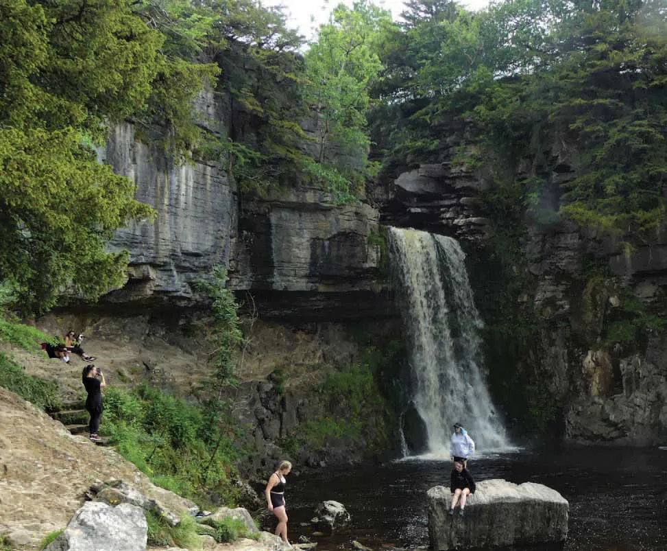
Thornton Force in the Yorkshire Dales. The lip of the fall is formed from layers of grey Carboniferous limestone. Below these limestone layers are revealed much older brown-coloured rocks, comparable to the slates and sandstones of the Lake District.
Many of the sediments that gave rise to the rocks of all three of the main divisions originally contained clays, and have been converted to slates by being deeply buried and squeezed during large-scale earth movements in the distant past. Slates are therefore common in all three of the main divisions of Lakeland rocks, and have been of great importance in the economy of the region. (The origin of slates is discussed in more detail in Chapter 5.)
Both Otley and Sedgwick recognized a fourth category: granites. These formed when molten rock created deep within the crust rose upwards, forcing its way into the other rock groups. The two main areas of granite are around Eskdale in the southwest, and between Ennerdale and Buttermere. Smaller outcrops occur near Skiddaw and Shap.
The mountainous Lake District
The Lake District is often referred to as being ‘mountainous’, but this does not refer only to its height. The Lake District fells are indeed high by English standards, but not exceptionally so. Cross Fell in the northern Pennines rises to 893m - higher than all but a handful of Lakeland fells - and the Pennines as a whole have a greater area of land over 600m. ‘Mountainous’ in this context means that the Lake District fells share many characteristics with major mountain ranges - steep slopes, deep valleys, rocky peaks, and so on - but on a small scale.
Why is this? Well, a superficial answer might be that the Lake District rocks are harder than those surrounding them, and so they have resisted erosion. Like many simple answers, this has some foundation in truth, but fails to get to the heart of the matter. The gentle landscape surrounding the Lake District is certainly formed from younger rocks, but it is debatable whether they are particularly soft and easily eroded. The red sandstones of the Eden valley and the Solway coast are hard enough to make excellent building stones, for example, while the limestones and sandstones that extend east to the Pennines give rise to extensive high plateaux, including Cross Fell.
A more accurate answer might be that, over geological time, the area has actually risen up, relative to its surroundings. Rocks like those of the Lake District are in fact present below much of England but they are normally hidden hundreds of metres below the surface. There is plenty of evidence to support this version of events. For instance, in some places at the edge of the National Park, such as Scout Scar, younger rocks clearly sit on top of much older ones. The same relationship is seen further east, in the deep valley bottom of the Ingleton Waterfalls Walk, off the A65 in the Yorkshire Dales. Here, erosion has cut down through the overlying limestone to reveal more ancient rocks, very like those seen in the Lake District.
So it is likely that limestones (like those of the Pennines), and other sedimentary rocks, were originally deposited above the rocks of the present-day Lake District. They were then removed by erosion, not because they were particularly soft, but because earth movements lifted up the Lake District relative to surrounding areas.

Geological map of the Lake District, showing the location of the described excursions. The old rocks of the Lake District form three distinct northeast-southwest bands, with the younger rocks in a ring around them.

Cumbria from space (ESA Sentinel 2 image, June 2020). Skiddaw Group and Bo...
Table of contents
- Cover
- Halftitle
- Title
- Copyright
- Contents
- Natural Forces
- 2 Sculpting the Landscape with Ice
- 3 Sculpting the Landscape with Water
- 4 Time Travel
- 5 Making Lakeland’s Rocks
- 6 Geology and Scenery
- Humans, Geology and Landscape
- 8 Wool, Walls and Wood
- 9 From Crags to Riches
- 10 Protecting a Fragile Landscape
- The Excursions
- 2 The Skiddaw Granite in Sinen Gill
- 3 Volcanic Rocks in Seathwaite
- 4 Coniston Copper Mines
- 5 Beatrix Potter’s Silurian Country
- 6 Around Tarn Hows
- 7 Limestone Landscape at Whitbarrow Scar
- Further Reading
- Image Credits
- Index
Frequently asked questions
Yes, you can cancel anytime from the Subscription tab in your account settings on the Perlego website. Your subscription will stay active until the end of your current billing period. Learn how to cancel your subscription
No, books cannot be downloaded as external files, such as PDFs, for use outside of Perlego. However, you can download books within the Perlego app for offline reading on mobile or tablet. Learn how to download books offline
Perlego offers two plans: Essential and Complete
- Essential is ideal for learners and professionals who enjoy exploring a wide range of subjects. Access the Essential Library with 800,000+ trusted titles and best-sellers across business, personal growth, and the humanities. Includes unlimited reading time and Standard Read Aloud voice.
- Complete: Perfect for advanced learners and researchers needing full, unrestricted access. Unlock 1.5M+ books across hundreds of subjects, including academic and specialized titles. The Complete Plan also includes advanced features like Premium Read Aloud and Research Assistant.
We are an online textbook subscription service, where you can get access to an entire online library for less than the price of a single book per month. With over 1.5 million books across 990+ topics, we’ve got you covered! Learn about our mission
Look out for the read-aloud symbol on your next book to see if you can listen to it. The read-aloud tool reads text aloud for you, highlighting the text as it is being read. You can pause it, speed it up and slow it down. Learn more about Read Aloud
Yes! You can use the Perlego app on both iOS and Android devices to read anytime, anywhere — even offline. Perfect for commutes or when you’re on the go.
Please note we cannot support devices running on iOS 13 and Android 7 or earlier. Learn more about using the app
Please note we cannot support devices running on iOS 13 and Android 7 or earlier. Learn more about using the app
Yes, you can access Lake District by Ian Francis,Stuart Holmes,Bruce Yardley in PDF and/or ePUB format, as well as other popular books in Physical Sciences & Geology & Earth Sciences. We have over 1.5 million books available in our catalogue for you to explore.