The spatial turn has brought forward new analytical imperatives about the importance of space in the relationship between physical and social networks of meaning. This volume explores this in relation to approaches and methodologies in the study of urban space in Roman Italy.
As a consequence of these new imperatives, sociological studies on ancient Roman cities are flourishing, demonstrating a new set of approaches that have developed separately from "traditional" historical and topographical analyses. Rethinking the Roman City represents a convergence of these different approaches to propose a new interpretive model, looking at the Roman city and one of its key elements: the forum. After an introductory discussion of methodological issues, internationally-know specialists consider three key sites of the Roman world – Rome, Ostia and Pompeii. Chapters focus on physical space and/or the use of those spaces to inter-relate these different approaches. The focus then moves to the Forum Romanum, considering the possible analytical trajectories available (historical, topographical, literary, comparative and sociological), and the diversity of possible perspectives within each of these, moving towards an innovative understanding of the role of the forum within the Roman city.
This volume will be of great value to scholars of ancient cities across the Roman world, well as historians of urban society and development throughout the ancient world.
Trusted by 375,005 students
Access to over 1.5 million titles for a fair monthly price.
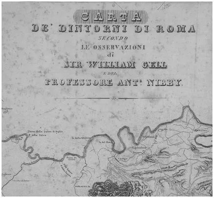
If one can identify a divergence between two traditions of topography, one, typically favoured by British scholars, concerned in the first place with landscape and the spatial context of human activity, the other, typically favoured by Italian scholars, concerned primarily with physical structures and the evidence, literary, epigraphic and historical associated with them, then this divergence seems already apparent in the collaboration between Sir William Gell and Professor Antonio Nibby in the early 19th century. It was their collaboration that produced one of the most important and influential studies of the environs of Rome, the Tentamen Topographicum or Carta de’ dintorni di Roma, published in map form in 1827 (Figure 1.1). They brought together highly complementary skills from two very different traditions. Their collaboration illustrates well the enormous benefits derived from the cross-fertilization of these traditions, benefits that were to be illustrated again and again in the following centuries by the work associated with the British School at Rome, from Thomas Ashby to John Ward-Perkins, each of them enthusiastic collaborators with their Italian opposite numbers. But the same Gell-Nibby collaboration betrays the extent to which the fault-lines remained, and far from producing one new integrated tradition, led to an enduring divergence.
The collaboration of this disparate couple dates back to 1820, when they worked together to produce a new survey and discussion of the walls of Rome, Le mura di Roma. To this joint enterprise they each brought an impressive background in publications. Gell, the elder of the two (born in 1777), had travelled extensively in the Mediterranean.2 His diplomatic mission to Ottoman Ionia in 1803 gave him the opportunity to put Iris skills as a draughtsman to the test in a brilliant collaboration with Edward Dodwell (though it did not as the DNB claimed lead to his knighthood), and led to widespread acclaim for his topographical writings, noticed somewhat satirically by Byron (whose initial “I leave topography to coxcomb Gell” was emended to “Classic Gell”, and then “rapid Gell”, the last because he surveyed the Troad in a mere three days). Next (in 1804) he toured Greece with Edward Dodwell. leading to publications on Ithaca (1807), the Itinerary of Greece (1810) and the Morea (1817), each a composite of travelogue, antiquarian learning and exquisite watercolour views.
From 1814 he was in Italy as chamberlain of the ill-fated Princess Caroline, whom the Prince Regent tried unsuccessfully to divorce on his accession as George IV in 1820. It was here that he pursued, in collaboration with John Gandy, the project that was to make his international fame, the description of the recent excavations in Pompeii, the Pompeiana, which appeared in two volumes in 1819.3 To his approach and methods I will return, but in terms of reputation, by the time he took up residence in Rome in 1820. he was already a figure of established renown as a topographer.
Figure 1.1 Title of Gell and Nibby’s Carta de’ dintorni di Roma, from Nibby’s revised edition of 1837.
Antonio Nibby, though 15 years Gell’s junior, and a mere 28 in 1820, was also a figure of established reputation, promoted in that same year to the chair of archaeology at the Archiginnasio Romano (the future La Sapienza). He worked in a long tradition of Roman topography. Between 1818 and 1820 he was responsible for a four-volume updated edition of Famiano Nardini’s Roma antica, establishing himself as the author of the most authoritative guide to Roman antiquities;4 at the same time he revised Vasi’s Roman itinerary and produced his own collection of the principal monuments of Rome.5 In the following year (1819), he published an archaeological survey of main monuments of the centre of Rome, Del ForoRomano della via sacra dell’anfiteatro favio e de’ luoghi adjacenti. Among his claims to topographic fame was his identification of the Basilica of Constantine (or Maxentius), previously taken for the Templum Pads. Simultaneously with his studies of Roman topography, he was working on the environs of Rome. In 1819 he produced the two volumes on Viaggio antiquario ne conform di Roma, a thorough account of the principal sites of the agro romano.
The collaboration of 1820 on the walls of Rome was thus between two wellestablished and widely published hgures. As its introduction stresses, it represented original research: there was a vast bibliography on other monuments of Rome, but the walls, startlingly, had never been studied, and in a very short time they were able to put together a topographic discussion accompanied by a map of the city and its walls, and 31 handsome copper plates, illustrating stretches of the walls, and in particular the gates. The success of the joint project led to a further and more important collaboration on the environs of Rome, a project that started in 1822 and lasted five years. As is clear from the way they write about each other in their prefaces, they had highly complementary skill sets and respected each other for them. Gell, though a graduate of Cambridge and elected a fellow of Emmanuel College, and therefore well educated in the Classics, did not feel full confidence in handling the written sources. Just as he used John Gandy to provide this dimension for Pompeii, he looked to the learning of Nibby, and his close knowledge of the Italian topographic tradition, which hinged on interpretation of the sources. Gell’s own expertise lay in the visual and spatial. As Nibby put it,
sir William Gell assunse a se la triangolazione de’luoghi, e la dilineazione del suolo; io indossai il fardello delle ricerche storiche ed antiquarie; ambedue poi separatamente perlustrammo le terre, onde poteme indicare i particolari.
(Analisi v)
The division of labour between Gell the map-maker and Nibby the antiquarian was clear, but in practice not complete, for Nibby soon found himself recruited as an assistant map-maker. As he continues:
Ed io particolarmente delineai sui luoghi quei tratti che Gell a cagione dello stato infelice di sua salute non poteva perlustrare.
(ibid)
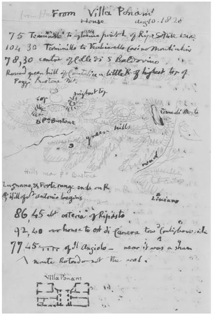
Cell notoriously suffered from gout, a condition which eventually killed him. and one may wonder at his sheer determination in undertaking a project which involved many miles of walking through rough and steep terrain, since his method involved reaching high points from which to triangulate the surrounding countryside (Figure 1.2). Just how close this collaboration became emerges vividly from Nibby’s notebooks from his fieldwork, which are preserved in the archive of the British School at Rome. The first dozen or so pages consist almost entirely of notes on the literary and epigraphic sources which he was expected to collect. But then we find him accompanying Gell on his fieldtrips and gradually acquiring the
Figure 1.2 Page of Gell’s notebook for 10 August 1828, showing use of trigonometric readings from Villa Ponam.
essential skills of surveying, making sketches of interesting features and views and sketching maps of specific areas (Figures 1.3-1.4). He rapidly became proficient. though the one feature that is missing is the feature that characterizes Gell’s own notebooks (held by the same archive), namely, lists of numbers derived from the trigonometric readings taken from each viewpoint (Figure 1.2).
On this account of the collaboration. Gell may sound like a mere technician and Nibby the true topographer. But the relationship was considerably more complex. Gell was indeed a skilled technician who mastered the use of the latest technology: in the case of the Pompeicma, his forte was die use of the camera lucida, which enabled him to draw buildings with a level of accuracy only surpassed by the photography, which emerged immediately after his death in 1836.6 For topographical surveying, his chosen instrument was the sextant. As he explains:
triangulation was constructed by means of a small sextant, made by Berge, the successor of Ramsden.
(Topography iv)
As we will see. his use of the latest instrumentation did indeed enable him to take map-making for Italy to a new level of accuracy. But he was also a man driven by intellectual curiosity.
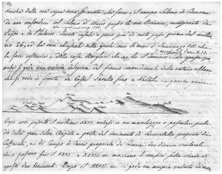
Figure 1.3 Page from Nibby’s notebook showing the view of the Alban Hills as seen from the casa Borghese, from Castel Savello to Velletri, "una veduta deliziosa”.
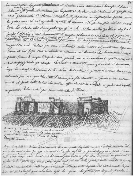
Figure 1.4 Page from Nibby’s notebook showing the citadel of Ardea.
In the preface to his Topography of Rome and Its Vicinity, he explains the nature of his collaboration with Nibby. Their original project was concerned with the territory of archaic Rome, the Rome of the kings:
The impossibility of procuring information from existing maps or books, respecting those places which existed contemporaneously with early Rome, or previous to its foundation, was the first inducement to examine the country; a map of Roman territory, under the kings, being all that was first intended.7
But as he goes on to explain, that would mean on the one hand going as far south as Suessa Pometia. and on t...
Table of contents
Cover
Half Title
Series
Title
Copyright
Dedication
Contents
List of figures
List of contributors
Acknowledgements
Introduction
PART I Methodological approaches
1 Topography between two worlds: William Gell and Antonio Nibby
2 Some thoughts on current trends in archaeology of once-townscapes compared with rural landscapes in the Mediterranean world
PART II Cities with optimal data: Rome, Ostia and Pompeii
3 Topography and Classical Archaeology: landscape Biography
4 Sensory-Spatial History at Ostia: embodied Space of Street Porticoes
5 Rethinking Relationships between Ostia and Portus
6 Visual communication in the streets of Pompeii
PART III A key public space in the Roman city: the Forum
7 Archaeologists in the Forum
8 Historians in the Forum
9 Children and Public Space in Early Imperial Rome
10 Transformations of public space in the cities of Italy under the Principate: the case of the Forum
Index
Frequently asked questions
Yes, you can cancel anytime from the Subscription tab in your account settings on the Perlego website. Your subscription will stay active until the end of your current billing period. Learn how to cancel your subscription
No, books cannot be downloaded as external files, such as PDFs, for use outside of Perlego. However, you can download books within the Perlego app for offline reading on mobile or tablet. Learn how to download books offline
Perlego offers two plans: Essential and Complete
Essential is ideal for learners and professionals who enjoy exploring a wide range of subjects. Access the Essential Library with 800,000+ trusted titles and best-sellers across business, personal growth, and the humanities. Includes unlimited reading time and Standard Read Aloud voice.
Complete: Perfect for advanced learners and researchers needing full, unrestricted access. Unlock 1.5M+ books across hundreds of subjects, including academic and specialized titles. The Complete Plan also includes advanced features like Premium Read Aloud and Research Assistant.
Both plans are available with monthly, semester, or annual billing cycles.
We are an online textbook subscription service, where you can get access to an entire online library for less than the price of a single book per month. With over 1.5 million books across 990+ topics, we’ve got you covered! Learn about our mission
Look out for the read-aloud symbol on your next book to see if you can listen to it. The read-aloud tool reads text aloud for you, highlighting the text as it is being read. You can pause it, speed it up and slow it down. Learn more about Read Aloud
Yes! You can use the Perlego app on both iOS and Android devices to read anytime, anywhere — even offline. Perfect for commutes or when you’re on the go. Please note we cannot support devices running on iOS 13 and Android 7 or earlier. Learn more about using the app
Yes, you can access Rethinking the Roman City by Dunia Filippi in PDF and/or ePUB format, as well as other popular books in History & Ancient History. We have over 1.5 million books available in our catalogue for you to explore.