Ovid tells the story of Latona, the mother by Jupiter of Apollo and Diana. In her flight from the jealous Juno, she arrives faint and parched on the coast of Asia Minor. Kneeling to sip from a pond, Latona is met by the local peasants, who not only deny her effort but muddy the water in pure malice. Enraged, Latona calls a curse down upon the stingy peasants, turning them to frogs.In his masterful study, Thomas F. Hedin reveals how and why a fountain of this strange legend was installed in the heart of Versailles in the 1660s, the inaugural decade of Louis XIV's patronage there. The natural supply of water was scarce and unwieldy, and it took the genius of the king's hydraulic engineers, working in partnership with the landscape architect André Le Nôtre, to exploit it. If Ovid's peasants were punished for their stubborn denial of water, so too the obstacles of coarse nature at Versailles were conquered; the aquatic iconography of the fountain was equivalent to the aquatic reality of the gardens. Latona was designed by Charles Le Brun, the most powerful artist at the court of Louis XIV, and carried out by Gaspard and Balthazar Marsy. The 1660s were rich in artistic theory in France, and the artists of the fountain delivered substantial lectures at the Académie royale de peinture et de sculpture on subjects of central concern to their current work. What they professed was what they were visualizing in the gardens. As such, the fountain is an insider's guide to the leading artistic ideals of the moment.Louis XIV was viewed as the reincarnation of Apollo, the god of creativity, the inspiration of artists and scientists. Hedin's original argument is that Latona was a double declaration: a glorification of the king and a proud manifesto by artists.
eBook - ePub
The Fountain of Latona
Louis XIV, Charles Le Brun, and the Gardens of Versailles
- 320 pages
- English
- ePUB (mobile friendly)
- Available on iOS & Android
eBook - ePub
About this book
Trusted by 375,005 students
Access to over 1.5 million titles for a fair monthly price.
Study more efficiently using our study tools.
Information
Publisher
University of Pennsylvania PressYear
2022Print ISBN
9780812253757
9780812253757
eBook ISBN
9780812298376
Topic
ArtSubtopic
History of ArtCHAPTER 1
Foundations
During the second half of 1666, workers in the gardens of Versailles inserted wire grates in the discharge pipes of twelve basins “to prevent dirt and toads from entering.” Identical measures, “to prevent frogs from entering,” were taken in 1667 and again in 1668. The little meddlers seem to have been plotting to avenge their Lycean forebears by sabotaging the hydraulic system of Louis XIV! Their assaults ended once and for all in 1669.1 The system had prevailed over nature’s repeated and determined efforts to obstruct it.
Of the twelve pipes, three originated in the Parterre de Latone, the wide-open space inside the arms of the Fer-à-Cheval. Three basins resided there at the time of the batrachian invasions, each equipped with a pipe for the release of surplus water into the nearby woods. They were arranged in a triangular pattern and are not difficult to locate in the center of garden-wide plans from 1666 (fig. 10) and 1668 (fig. 11). The basin along the axis is oval in shape, the two companions round. The trio appears in the sunlit background of a bird’s-eye view of 1668 from the brush of Pierre Patel (figs. 12, 13).2
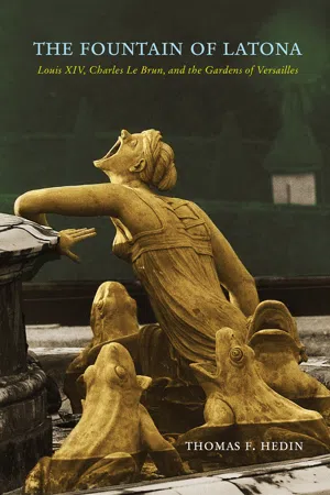
The scenic fountains of the Parterre de Latone were carried out between 1666 and 1670. All three were designed by Charles Le Brun, the premier peintre du roi, far and away the most powerful artist at the court of Louis XIV. To convert his designs into three dimensions, Le Brun called on the Marsy brothers, Gaspard and Balthazar, two of the most trusted members of his team of sculptors. In the center of the oval basin, Le Brun placed the heroine who lent her name to the vicinity (fig. 2). She and her twins were marooned on an island rising just above water level; they faced the château, to the east. Except for a narrow shoreline, the island was no larger than the ensemble. There was no escaping the menace of the six adult peasants, each of whom was transformed into a frog to some degree; full frogs, former peasants that they once were, sat in regular intervals along the grassy border. In the round basins were the so-called Lizard fountains, a pair of young peasants in each, a clump of marsh reeds, or aigrettes, separating them; their grassy borders were inhabited by turtles, crocodiles, and lizards, not to mention still more frogs.3 The entire Lycean community was cast in lead, then gilded, in stunning contrast to the white Carrara marble of the Latona group.4 When we discuss Latona in general terms, let it be agreed that both Lizards are included in the conversation.
To Begin, the Landscape …
The gardens of Versailles were some forty years old when the Ovidian episode of Latona and the Lycean peasants was programmed for the spinal axis in the middle of the 1660s. Indeed, there had already been several earlier phases of elaboration, each a pointed response to its predecessor.
The forests to the southwest of Paris were rich in game, and the allure of the rustic surroundings inspired Henri de Bourbon, later Henri IV, to hunt there over the course of several decades.5 Louis XIII, who succeeded his father on the throne in 1610, continued the royal practice, traveling periodically from Paris or Saint-Germain-en-Laye with friends to hunt in the woods near Versailles, sometimes even spending the night in a shack or barn. In 1623, he abandoned his carefree ways and ordered the construction of a house of cheap, impermanent materials “for his use, on the rising ground of the windmill near [the village of] Versailles”—so reads a legal agreement of that year.6 The humble style of the house befit the rustic setting. There is reason to attribute the design to the king, or to associate it closely with him. In form it was fortlike, a square courtyard framed on the sides by stables and kitchens and at the back by living quarters, the whole surrounded by a moat and, farther out, by a wall. The house opened onto a pair of four-part parterres, one of which displaced the windmill. The estate was laid out along an east-west axis, the same spinal axis that divides the gardens in half today. An expanse of fields, lying just beyond the twin parterres and on lower ground, was then acquired. No plan or view of this initial phase is known to exist, but a recent reconstruction by Jean-Claude Le Guillou is a superb substitute.7
Toward the end of the 1620s, about two-thirds of the acquired fields were subdivided by allées into ten quadrangles, a gigantic Saint Andrew’s Cross cutting through the heart of the grid.8 In 1631, Louis XIII responded to the new acquisition of land by replacing the house with a larger, more commodious stone-and-brick château on the designs of Philibert Le Roy. To the ten quadrangles already in place, a supplemental four were purchased at the close of the 1630s, opening up enough land for the spinal axis to reach as far as the Bassin des Cygnes, yet another new feature.9 The “Du Bus plan,” though it was executed at the outset of the 1660s and distorts the relative proportions of the quadrangles, is a witness to this phase of evolution (fig. 8).10 Out front, the twin parterres gave way to a single square parterre with an inner square of allées and a central basin. A basin was inserted at the intersection of the Cross.
Our visual guide to the next, penultimate phase is the “Institut plan” of 1663 (fig. 9).11 Ephemeral though it was, the plan is a record of the earliest contributions of the great landscape architect André Le Nôtre.12 His plan featured three independent gardens, one for each facade; each garden was equal in width to the facade overlooking it, and a central axis ran through each.13 The Orangerie of Louis Le Vau had been constructed to the south in the previous year, in coordination with Le Nôtre’s new gardens on that side, one for flowers, others for vegetables and fruit, another for an orchard. He covered the northern axis with lawns, basins of assorted shapes, and a cascade that narrowed as it fell away, lending an illusory depth to the view; some but probably not many of the aquatic features shown here were realized.14 On the Grand Parterre in front of the western facade he planted two rectangular lawns, separating them by a walk that led to a round basin and a pair of small, segmental lawns; there, the ground began sloping down.15 The outer ramps arched inward on their descent, meeting at the bottom and traveling together to a second round basin, then to a square intersection, and finally to the Bassin des Cygnes.16 He eliminated the Saint Andrew’s Cross in favor of twin quinconces, the so-called Deux-Bosquets, one on each side of the spine.17
No sooner had Le Nôtre transformed the gardens than he did so again, this time thoroughly and, for the most part, lastingly. To this day, the gardens of Versailles have never undergone a more profound change. With this phase, which opened in 1664–65, we enter the world of our Latona. Three (nameless) plans from 1666 alert us to the magnitude of his alterations (e.g., fig. 10),18 as do three from 1668 (e.g., fig. 11).19 The south, already the site of the Orangerie and the gardens of natural produce, remained essentially the same. By contrast, Le Nôtre radically revised the north, doubling it in size by shifting the axis to the west and by formalizing the blocks of land on that side; the upper half of the new territory, at first called the Parterre de Gazon and later the Parterre du Nord, was split into two equal parts, a round basin in each; a long pathway, the Allée d’Eau, led to a large round basin, the Rondeau (Chapter 2).
The western axis, our primary attention, was reformed no less radically than its northern cousin. The approach from upper to lower level, which on the Institut plan had taken the form of arching ramps that converged at the bottom, now consist of ramps that diverge at the top, widening as they drop down and embracing a vast open space below, the “nouvelle parterre,” as it was known in the middle of 1665.20 The nouvelle parterre was later identified as the Parterre de l’Ovale for the shape of the axial basin, and still later as the Parterre de Latone for the Titaness who ruled over it. At first, the reconstructed area as a whole was called the “demi-lune” or “amphithéâtre,” but “Fer-à-Cheval” was soon preferred.
Pedestrians descend the Fer-à-Cheval in stages, by taking a flight of eleven steps to a first landing, then a flight of fourteen steps to a wider second landing; at each end of this lower landing, a narrow flight of steps leads to the floor of the gardens. The outer ramps were graded to accommodate wheeled vehicles.
On top, the two rectangular lawns on the Grand Parterre gave way to the more spacious Parterre de Broderie, and the round basin at the end was superseded by a larger one—a basin, though it lay above, that played a surprising role in the origins of Latona (Chapter 7). It took much more than a year of herculean effort by the landscapers to level the end of the Grand Parterre and to contour the Fer-à-Cheval.
The boundaries of the gardens had been defined in the 1630s by the formation of the fourteen-unit grid. This “Petit Parc,” as it was called early on, was bordered on the south by the Orangerie and on the north by the Rondeau; the château framed it on the east, the Bassin des Cygnes on the west. Ranging beyond the edges of the “Petit Parc” was the “Grand Parc,” a wild preserve for hunting, shooting, and riding. The Ménagerie of Le Vau, from 1662, lay to the southwest (fig. 10, upper left corner).
… And, Together with the Landscape, the Water …
André Félibien, the author of the first official guidebook of Versailles and the historiographe of the Bâtiments du Roi, was attentive to the same topographical features that stand out in Louis XIII’s legal agreement of 1623. The château, he wrote in 1674, rests on “a little eminence rising at the middle of a wide valley surrounded by hills.”21 Just that casually he pointed to two blessings of the site: that the château lay atop an elevation, above a habitat for game and a source of water, was one; that the ground ran gradually downhill from the château, a precondition for a system of gravity-fed basins, was the other.
It is a high form of irony that in Ovid’s story the Lycean peasants deny the element of water to Latona and he...
Table of contents
- Cover
- Series Page
- Title Page
- Copyright
- Dedication
- Contents
- Acknowledgments
- Note on Measurements
- List of Illustrations
- Prologue
- Chapter 1. Foundations
- Chapter 2. Fountains in Context
- Chapter 3. Original State
- Chapter 4. Visual Narrative
- Chapter 5. Latona Group
- Chapter 6. Lycean Peasants
- Chapter 7. Panegyric and Manifesto
- Epilogue
- Photographs
- Appendix A. Execution of the Fountain
- Appendix B. Mansart’s Marble Cone
- Appendix C. Marsy’s Lecture of 7 December 1669
- Appendix D. Nathan Whitman’s “Fronde Thesis”
- Appendix E. Translations of Ovid
- Appendix F. Elaborations of the Western Axis, Briefly
- List of Abbreviations
- Notes
- Bibliography
- Index
Frequently asked questions
Yes, you can cancel anytime from the Subscription tab in your account settings on the Perlego website. Your subscription will stay active until the end of your current billing period. Learn how to cancel your subscription
No, books cannot be downloaded as external files, such as PDFs, for use outside of Perlego. However, you can download books within the Perlego app for offline reading on mobile or tablet. Learn how to download books offline
Perlego offers two plans: Essential and Complete
- Essential is ideal for learners and professionals who enjoy exploring a wide range of subjects. Access the Essential Library with 800,000+ trusted titles and best-sellers across business, personal growth, and the humanities. Includes unlimited reading time and Standard Read Aloud voice.
- Complete: Perfect for advanced learners and researchers needing full, unrestricted access. Unlock 1.5M+ books across hundreds of subjects, including academic and specialized titles. The Complete Plan also includes advanced features like Premium Read Aloud and Research Assistant.
We are an online textbook subscription service, where you can get access to an entire online library for less than the price of a single book per month. With over 1.5 million books across 990+ topics, we’ve got you covered! Learn about our mission
Look out for the read-aloud symbol on your next book to see if you can listen to it. The read-aloud tool reads text aloud for you, highlighting the text as it is being read. You can pause it, speed it up and slow it down. Learn more about Read Aloud
Yes! You can use the Perlego app on both iOS and Android devices to read anytime, anywhere — even offline. Perfect for commutes or when you’re on the go.
Please note we cannot support devices running on iOS 13 and Android 7 or earlier. Learn more about using the app
Please note we cannot support devices running on iOS 13 and Android 7 or earlier. Learn more about using the app
Yes, you can access The Fountain of Latona by Thomas F. Hedin in PDF and/or ePUB format, as well as other popular books in Art & History of Art. We have over 1.5 million books available in our catalogue for you to explore.