A pictorial history of the development of New York City's Central Park from conception to completion.
Drawing on the unparalleled collection of original designs for Central Park in the New York City Municipal Archives, Cynthia S. Brenwall tells the story of the creation of New York's great public park, from its conception to its completion. This treasure trove of material ranges from the original winning competition entry; to meticulously detailed maps; to plans and elevations of buildings, some built, some unbuilt; to elegant designs for all kinds of fixtures needed in a world of gaslight and horses; to intricate engineering drawings of infrastructure elements. Much of it has never been published before. A virtual time machine that takes the reader on a journey through the park as it was originally envisioned,
The Central Park is both a magnificent art book and a message from the past about what brilliant urban planning can do for a great city.
eBook - ePub
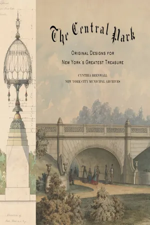
The Central Park
Original Designs for New York's Greatest Treasure
- 501 pages
- English
- ePUB (mobile friendly)
- Available on iOS & Android
eBook - ePub
About this book
Trusted by 375,005 students
Access to over 1.5 million titles for a fair monthly price.
Study more efficiently using our study tools.
Information
Topic
ArchitectureSubtopic
Architecture GeneralCHAPTER 1
THE GENIUS OF THE PLAN
By titling their plan for Central Park “Greensward,” a term used to describe a wide-open, grass-covered ground or turf, Calvert Vaux and Frederick Law Olmsted set the stage to transform a broken, swampy terrain with pockets of settlement into a pastoral oasis for millions of city dwellers. While the park looks and feels like the last remaining parcel of nature left on the island of Manhattan, it was almost entirely man-made. The composed landscape was created through a combination of visionary planning, brilliant engineering, and a massive human effort.
From a masterful drainage system devised by a twenty-four-year-old engineer to the decorative park benches created for the restful enjoyment of those promenading on the Mall, this chapter explores the infrastructure of Central Park. Drawings of features such as the underground technology that was required to prepare the Lake for winter skating; the sunken transverse roads used to carry traffic through the park without intruding on the flow of people, horses, and carriages within the park, not to mention its pastoral views; and the endless charming architectural details and thoughtful designs for more utilitarian additions, underscore the behind-the-scenes thought and labor needed to make the park an artistic masterpiece for the ages.
PARK DRAINAGE
Before construction began, the parkland’s 843 acres of rough and varied terrain contained five major watersheds, with a natural drainage system that flowed out toward the East River. Thanks to the poor quality of its soil and the high embankments—remnants of creating uniform street grades—that surrounded it, many areas were filled with pools of stagnant water. Engineer-in-Chief Egbert Viele, who had undertaken a topographical survey of the site before assuming his position, warned the Board that if the land was not properly drained, it would remain, “a pestilential spot, where rank vegetation and miasmatic odors taint every breath of air.” In addition to health concerns caused by the standing water, drainage was also imperative to maintaining the loose, fertile soil required for the vast amount of planting that would be needed to turn the bleak landscape into the parkland that the city was expecting.
Twenty-four-year-old engineer George E. Waring Jr. was hired to develop and implement a drainage system, a monumental effort that made the park possible. In June of 1858, Waring and a team of four hundred laborers began digging ditches, opening natural streams, and clearing trenches three to four feet deep at forty-foot intervals to install a system of drain tiles—essentially perforated clay pipes that collect water from the surrounding soil. The pipes drew water down into collecting drains, and where several drains met, a silt basin was placed to allow water to pass while removing any foreign materials.
By December 1858, Waring and his team had laid over twenty miles of drain tile, created thirteen basins, and had managed to reroute enough water to fill the twenty-acre Lake to the depth of four feet, in order for it to be ready for the 1859 winter ice-skating season.1 Olmsted reported to the Board in March of that year that “the results of the drainage, thus far, had been satisfactory, many parts of the Park which were impassable swamps before drainage, being now hard and dry. Various pools of standing water have disappeared and from their bottoms thousands of loads of muck, valuable as manure, have been taken for cultivation.”2
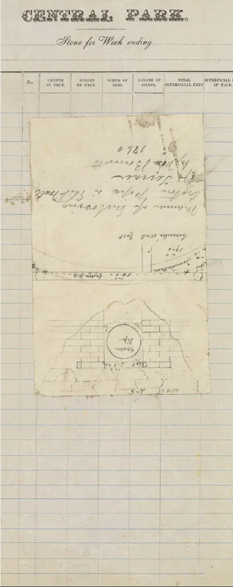
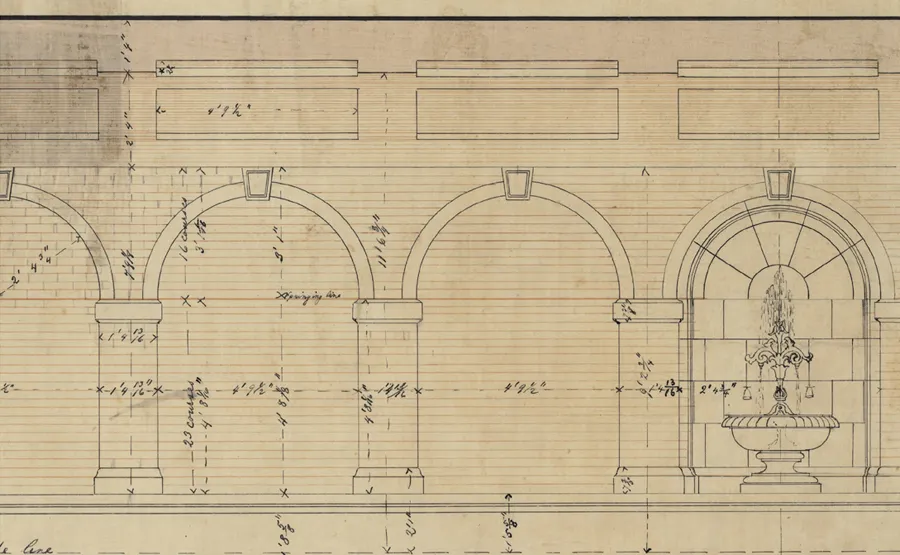
Manner of enclosing Croton pipe in east wall of the Terrace, 1860. Pencil on paper pasted on printed letterhead, 13½ × 8¼″.
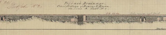
Plan of Terrace drainage, showing drains and basin, 1863. Black and red ink colored washes and pencil on graph paper, 16¼ × 13¼″.
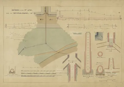
Sewers across Eighth Avenue and in Central Park at Eighty-Eighth Street, 1884. Black and red ink with colored washes on cloth-backed paper, 28¾ × 42″. Approved by engineer Montgomery A. Kellogg, March 8, 1884.
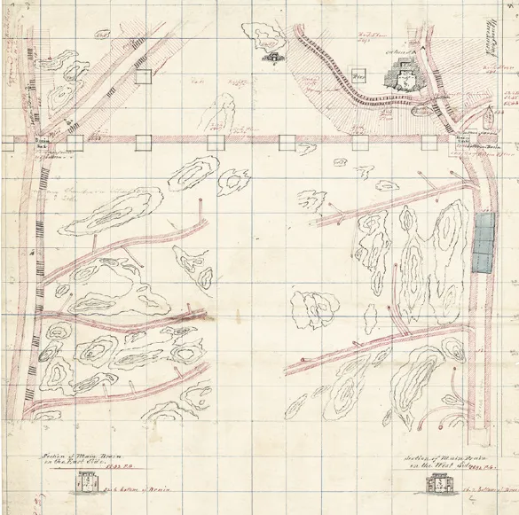
Design of main drains for Terrace and Mall, c. 1863. Black and red ink with colored washes, pencil, and crayon on graph paper, 16¼ × 13¼″.
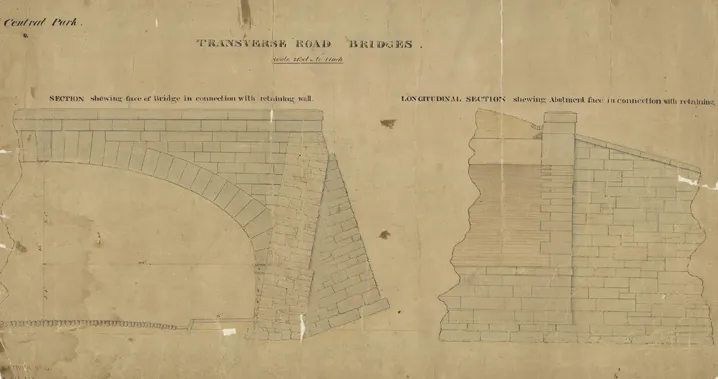
Transverse Road bridge showing the abutments and retaining walls, c. 1859. Black and red ink with colored washes on cloth-backed paper, 19¾ × 34½″.
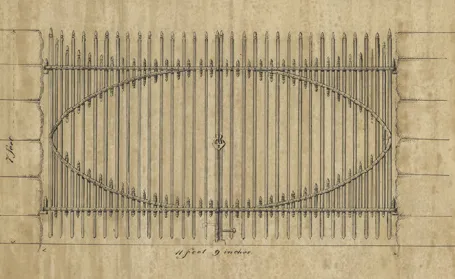
Elevation of a gate for the Transverse Roads, 1863. Black ink and gray wash on linen, 13¼ × 25½″.
TRANSVERSE ROADS
Vaux and Olmsted’s traffic circulation system for Central Park is often considered the genius of their plan. Especially notable were the Transverse Roads (referred to as thoroughfares until 1862), which enabled east-west traffic to pass through the park. Early park biographer Frederick B. Perkins wrote, “so simply and plainly did this device meet the case [of separating the park from crosstown traffic], that it had much weight in the deciding of the Board of Commissioners to adopt the plan which contained it.”3
Even though the majority of New Yorkers lived far south of the park in 1857, the Board of Commissioners recognized that development would move northward and that provision for crosstown traffic would have to be made. Egbert Viele’s rejected plan for the park had included thoroughfares across the park, and the design competition rules specified that at least, “four or more crossings from east to west be made between Fifty-ninth and One Hundred and Sixth Street.” Ironically, shortly after the Greensward plan was selected as the winner, two of the commissioners, August Belmont and Robert J. Dillon, unsuccessfully advocated for eliminating the Transverse Roads, stating that, “there will be little or no such business relations of one side with the other as to require vehicles of traffic to cross the Park.”4
Vaux and Olmsted came up with an ingenious scheme for these Transverse Roads that worked seamlessly to avoid fragmentation of the park. Unlike all of the other designers, who submitted plans showing the required roads at street level, they sank the roads out of sight, which made it possible to keep park visitors safely above the crosstown traffic, which they colorfully portrayed in their proposal as “coal carts and butchers’ carts, dust carts, dung carts” and fire companies “rushing their machines with fantastic zeal at every alarm.”5 The designers intended that the borders of the roads and the wide north-south bridges crossing them be heavily planted in an effort to create an appearance of endless parkland for park visitors.
A precursor to modern-day parkway construction, this bi-level road system was a new, albeit expensive, innovation that required extensive excavation and manpower. While Vaux designed the roads, it was William H. Grant who provided the engineering expertise. Together they developed a forty-foot-wide roadway that included a 6½-foot sidewalk on either side. The retaining walls were faced with Manhattan schist taken from the park, and the bridges were constructed from hard-burnt brick, although one on Transverse Road No. 2 had to be tunneled through the rock formation that made up Vista Rock, the second-highest peak in the park. The Transverse Roads posed an especially difficult drainage challenge, but Grant, working with J. H. Piper, conquered the problem. The roads, made up of a combination of cinder and gravel, were crowned and lined with granite gutters. Both the porous surface of the roadway and the gutters drained into a series of catch basins below the surface. The basins were connected to a storm-water collection area that drained into park waters or, in some cases, directly into the city sewer system.6 Completed between December 1859 and the fall of 1862, the Transverse Roads still provide uninterrupted routes across town without intruding on the...
Table of contents
- Cover
- Title Page
- Contents
- Foreword
- Introduction: The Greatest Single Work of Art in the City of New York
- Chapter 1: The Genius of the Plan
- Chapter 2: The South
- Chapter 3: The West
- Chapter 4: The North
- Chapter 5: The East
- Chapter 6: The Heart of It All
- Acknowledgments
- Notes
- Selected Bibliography
- Index
- Copyright Page
Frequently asked questions
Yes, you can cancel anytime from the Subscription tab in your account settings on the Perlego website. Your subscription will stay active until the end of your current billing period. Learn how to cancel your subscription
No, books cannot be downloaded as external files, such as PDFs, for use outside of Perlego. However, you can download books within the Perlego app for offline reading on mobile or tablet. Learn how to download books offline
Perlego offers two plans: Essential and Complete
- Essential is ideal for learners and professionals who enjoy exploring a wide range of subjects. Access the Essential Library with 800,000+ trusted titles and best-sellers across business, personal growth, and the humanities. Includes unlimited reading time and Standard Read Aloud voice.
- Complete: Perfect for advanced learners and researchers needing full, unrestricted access. Unlock 1.5M+ books across hundreds of subjects, including academic and specialized titles. The Complete Plan also includes advanced features like Premium Read Aloud and Research Assistant.
We are an online textbook subscription service, where you can get access to an entire online library for less than the price of a single book per month. With over 1.5 million books across 990+ topics, we’ve got you covered! Learn about our mission
Look out for the read-aloud symbol on your next book to see if you can listen to it. The read-aloud tool reads text aloud for you, highlighting the text as it is being read. You can pause it, speed it up and slow it down. Learn more about Read Aloud
Yes! You can use the Perlego app on both iOS and Android devices to read anytime, anywhere — even offline. Perfect for commutes or when you’re on the go.
Please note we cannot support devices running on iOS 13 and Android 7 or earlier. Learn more about using the app
Please note we cannot support devices running on iOS 13 and Android 7 or earlier. Learn more about using the app
Yes, you can access The Central Park by Cynthia S. Brenwall,Martin Filler in PDF and/or ePUB format, as well as other popular books in Architecture & Architecture General. We have over 1.5 million books available in our catalogue for you to explore.