Proceedings of the 10th Regional Conference for Africa on Soil Mechanics and Foundation Engineering and the 3rd International Conference on Tropical and Residual Soils, held in Maseru, Lesotho, September 1991, are contained in two volumes. The papers address geotechnical problems peculiar to Africa and engineering solutions for local problems, as well as data on the properties of African soils.
eBook - ePub
Geotechnics in the African Environment, volume 1
Proceedings of 10th regional conference for Africa on soil mechananics foundation engineering & the 3rd international conference tropical & residual soils, Maseru, 23-27 September 1991, 2 volumes
- 426 pages
- English
- ePUB (mobile friendly)
- Available on iOS & Android
eBook - ePub
Geotechnics in the African Environment, volume 1
Proceedings of 10th regional conference for Africa on soil mechananics foundation engineering & the 3rd international conference tropical & residual soils, Maseru, 23-27 September 1991, 2 volumes
About this book
Trusted by 375,005 students
Access to over 1.5 million titles for a fair monthly price.
Study more efficiently using our study tools.
Information
Tenth African Regional Conference on Soil Mechanics and Foundation Engineering
1. Engineering geology, waste disposal and the environment
The engineering geology of the Wolwedans Dam
Geological Survey of South Africa, RSA
ABSTRACT: The gravity arch Wolwedans Dam in the Southern Cape, South Africa, is founded on schists possessing a well developed foliation. Site investigation comprised a comprehensive drilling programme as well as laboratory and in situ testing. Geotechnical aspects of construction which are discussed include the founding and tunnelling conditions, slope stability and foundation grouting.
1 INTRODUCTION
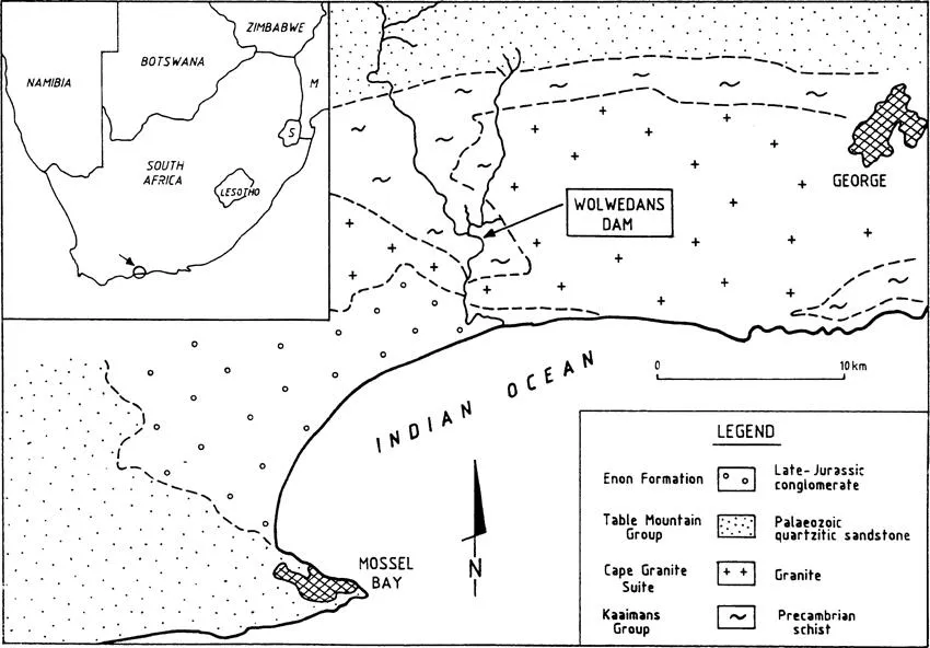
The recently completed Wolwedans Dam is located on the Great Brak River between the towns of George and Mossel Bay, South Africa (Figure 1). It is the major component in the water supply scheme for the Mossel Bay Gas Project; with water being transferred from the Wolwedans Dam to the Mossgas Plant via a system of pipelines, reservoirs and a pumping station over a distance of approximately 30 km.
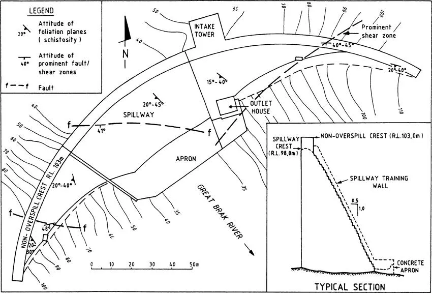
The 70 m high dam (Figure 2) was designed and constructed by the Department of Water Affairs and Forestry, using roller compacted concrete (rollcrete) and, together with the somewhat smaller Knellpoort Dam, became the world’s first gravity arch dams to be constructed by this method.
Certain statistics pertaining to the Wolwedans Dam are listed in Table 1.
2 GENERAL GEOLOGY
The dam is located in an area underlain by Precambrian meta-sediments, comprising schists, phyllites and quartzites, known as the Kaaimans Group (Figure 1); with the dam itself being founded on the schists of the Saasveld Formation. These metamorphic rocks are highly deformed and at least four periods of deformation are recognized (Gresse, 1983). As a result the rocks exhibit a well developed foliation which, in the general area of the Great Brak River, dips between 20° and 50° in a southwesterly direction.
Type of structure | gravity arch, rollcrete |
Crest length | approx. 270 m |
Height of non-overspill crest above lowest foundation | 71,6 m |
FSL (R.L.) | 98,0 m |
NOCL (R.L.) | 103,0 m |
Reservoir capacity at FSL | 24 million m3 |
These meta-sedimentary rocks have been intruded by syntectonic granites of the Cape Granite Suite.
The E-W striking Outeniqua Mountains, composed of Palaeozoic quartzites and quartzitic sandstones of the Table Mountain Group, delineate the northern boundary of the catchment area. These mountains form part of the Cape Fold Belt, and the high degree of shearing which characterizes the granites is considered to result from the tectonics associated with this folding.
Younger geological successions in the area are restricted to late-Jurassic sedimentary accumulations, which consist predominantly of conglomerate.
This portion of the Southern Cape constitutes an uplifted marine platform. During upliftment the river courses became incised, forming deep, steep-sided gorges and it is within such a gorge that the Wolwedans Dam is located.
3 DAM SITE INVESTIGATIONS
The Wolwedans Dam is the largest structure, to date, to be founded on the rocks of the Kaaimans Group. While the problems associated with construction on strongly foliated rocks, such as these schists, are by no means unique; the initial geological appraisal of the Wolwedans Dam foundation could not rely upon previously acquired information. It was therefore necessary for the site investigation to be directed firstly at the collection of basic data, and secondly at the determination of detailed parameters for design purposes.
Initial reconnaissance-level investigations were conducted as early as 1977, although detailed site investigation only commenced in 1985, with the drilling of 22 boreholes in the vicinity of a centre-line approximately 150 m upstream of the final position.
A detailed site survey led to the identification of a centre-line with a more favourable topography and the investigation subsequently shifted to this final position. Initially 23 boreholes were drilled here, although additional drilling on the left and right flanks brought the total number of boreholes drilled at this centreline to 34 (730 m).
3.1 Laboratory testing
Initial testing, restricted to limited uniaxial strength determinations using rock cores, proved that the rock material strength was strongly dependent on the schistosity (foliation).
Further testing was subsequently directed at the determination of shear strength parameters for discontinuities and intact rock.
The majority of the laboratory shear tests which were conducted on seventeen rock blocks and eight cores yielded residual friction angles in a band between 26° and 36°, with average residual cohesion of 19 kPa(CSIR, 1987a).
In addition, peak shear strength parameters were obtained by testing eleven core samples. Peak friction angles were predominantly between 35° and 44° with an average cohesion of 297 kPa.
A series of triaxial compressive strength tests were also conducted (CSIR, 1987b) from which internal friction angles and apparent cohesion were calculated (Table 2).
A pparent cohesion | Internal friction angle | |
High strength* | 38 MPa | 39° |
Medium strength* | 34 MPa | 21° |
Low strength* | 27 MPa | 17° |
*Subdivision into low, medium and high strength groups was based on the degree to which the schistosity was developed.
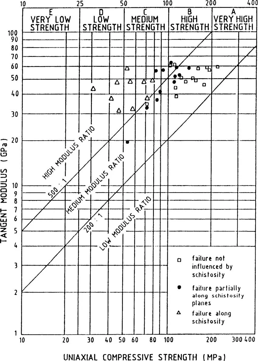
As a follow up to the in situ Goodman Jack testing, further laboratory strength and deformation tests were conducted on thirty six core samples (CSIR, 1988a). Classification of the results was made on the basis of the extent to which failure was influenced by the schistosity. It was concluded that the schistosity reduces the uniaxial compressive strength of the rock material to a far greater extent than its deformation modulus (Vogler, 1988) (Figure 3, after Deere and Miller, 1966).
3.2 In situ testing
The in situ deformation modulus was determined with the use of the Goodman Jack. A total of 176 tests, conducted at varying positions in 13 boreholes (CSIR, 1988b) to a maximum depth of 21 m, yielded values between 11 GPa and 66 GPA with a mean of 20,9 GPa. Lower modulus values were associated with greater weathering and smaller block sizes, i.e. closer jointing (Schall and Vogler, 1988). The higher moduli were therefore recorded in the river section and on the lower right flank; with lower values being recorded on the upper right flank and left flank.
In situ shear tests were initially planned but...
Table of contents
- Cover
- Half Title
- Title Page
- Copyright Page
- Preface
- Organising Committee
- Table of Contents
- Third International Conference on Tropical and Residual Soils
- Tenth African Regional Conference on Soil Mechanics and Foundation Engineering
Frequently asked questions
Yes, you can cancel anytime from the Subscription tab in your account settings on the Perlego website. Your subscription will stay active until the end of your current billing period. Learn how to cancel your subscription
No, books cannot be downloaded as external files, such as PDFs, for use outside of Perlego. However, you can download books within the Perlego app for offline reading on mobile or tablet. Learn how to download books offline
Perlego offers two plans: Essential and Complete
- Essential is ideal for learners and professionals who enjoy exploring a wide range of subjects. Access the Essential Library with 800,000+ trusted titles and best-sellers across business, personal growth, and the humanities. Includes unlimited reading time and Standard Read Aloud voice.
- Complete: Perfect for advanced learners and researchers needing full, unrestricted access. Unlock 1.5M+ books across hundreds of subjects, including academic and specialized titles. The Complete Plan also includes advanced features like Premium Read Aloud and Research Assistant.
We are an online textbook subscription service, where you can get access to an entire online library for less than the price of a single book per month. With over 1.5 million books across 990+ topics, we’ve got you covered! Learn about our mission
Look out for the read-aloud symbol on your next book to see if you can listen to it. The read-aloud tool reads text aloud for you, highlighting the text as it is being read. You can pause it, speed it up and slow it down. Learn more about Read Aloud
Yes! You can use the Perlego app on both iOS and Android devices to read anytime, anywhere — even offline. Perfect for commutes or when you’re on the go.
Please note we cannot support devices running on iOS 13 and Android 7 or earlier. Learn more about using the app
Please note we cannot support devices running on iOS 13 and Android 7 or earlier. Learn more about using the app
Yes, you can access Geotechnics in the African Environment, volume 1 by GeoffreyE. Blight,Geoffrey E. Blight in PDF and/or ePUB format, as well as other popular books in Technology & Engineering & Civil Engineering. We have over 1.5 million books available in our catalogue for you to explore.