eBook - ePub
Climate, Science, and Colonization
Histories from Australia and New Zealand
- English
- ePUB (mobile friendly)
- Available on iOS & Android
eBook - ePub
Climate, Science, and Colonization
Histories from Australia and New Zealand
About this book
Offering new historical understandings of human responses to climate and climate change, this cutting-edge volume explores the dynamic relationship between settlement, climate, and colonization, covering everything from the physical impact of climate on agriculture and land development to the development of "folk" and government meteorologies.
Trusted by 375,005 students
Access to over 1.5 million titles for a fair monthly price.
Study more efficiently using our study tools.
Information
Part I
Frames, Events, and Responses
Chapter 1
Australasia: An Overview of Modern Climate and Paleoclimate during the Last Glacial Maximum
Andrew M. Lorrey and Helen C. Bostock
Introduction
Australasia is a collection of landmasses inclusive of the large Australian continent, the microcontinent of New Zealand, Pacific islands within the Indonesian archipelago, and most islands within Melanesia.1 Australasia encapsulates a wide range of terrestrial climates, with several ecological zones, from the equatorial tropical zone to the temperate middle latitudes.
This chapter reviews the modern marine and terrestrial climates of Australasia, and contrasts modern climate with the Last Glacial Maximum (LGM), approximately 23,000 to 18,000 years ago. The comparison of modern Australasian climate to that of tens of millennia ago is relevant for understanding the entire scope of Australasian colonization, providing the context for largely unknown climatic and meteorological processes that impacted settlement of the region. The great spatial variations of climates across Australasia were important in shaping colonization, as subsequent chapters show. The contrast between modern climate conditions (about the last 150 years or so during the period of instrumental observations) with that of the LGM also stresses the dynamism of nonhuman climatic change (deep time) as a contrast to perceived human-induced climate change (see chapters 5 and 6).
Australasian terrestrial climates are strongly influenced and moderated by the surrounding oceans. The region is bounded to the west by the Indian Ocean, to the north by the Indo-Pacific Warm Pool, to the east by the Pacific Ocean, and to the south by the Southern Ocean. The oceanography around Australasia is complex and includes deep basins, shallow shelves, narrow passages, and submarine ridges. In addition, multiple atmospheric circulation features and climate drivers (unique processes acting on different time and spatial scales) are directly linked to the oceans. The marine climates of Australasia are reviewed later in the text, followed by an overview of the major atmospheric circulation features in the region. A discussion about modern climate drivers also illustrates how the climate features of Australasia are linked, and how they impact the region today to produce the myriad of regional and local climate conditions. The chapter finishes with an overview of LGM climate, which was vastly different from the conditions observed today.
Modern Oceanography and Marine Climate of Australasia
Western Australia
Northwest Australia is dominated by the Indo-Pacific Warm Pool with warm, low salinity, low nutrient surface waters (Figure 1.1).2 Marine waters in this region are warm and fresh due to high rainfall and runoff from the surrounding land. The Indonesian throughflow transports between 7 and 18 Sverdrups (106 cubic meters per second) of this warm, low salinity water through the Indonesian archipelago as a narrow band into the Timor Sea and the Indian Ocean.3
The Indonesian throughflow continues south as the Leeuwin Current along the Western Australia coast, becoming well defined from Northwest Cape to Cape Leeuwin at the southwestern tip of the continent.4 The Leeuwin Current is the eastern boundary current of the Indian Ocean, which flows south from the tropics until it meets the Subtropical Front between 38°S and 40°S.5 It then deflects around the south coast of Australia to form the South Australian Current, which flows as far west as Tasmania during the winter.6
Eastern Australia
The East Australian Current is the main surface current in the Coral and Tasman Seas. The shape of the sea bed (bathymetry) of the Torres Strait and Arafura Sea creates a major barrier to the exchange of water between the northeast and northwest of Australia. Hence these two marine regions have very different characteristics. This is clearly evident from a strong gradient in sea surface temperature and salinity on either side of the Torres Strait (Figure 1.1).
The East Australian Current forms from the warm, saline, low nutrient surface waters of the South Equatorial Current, which flows from east to west across the tropical Pacific and collides with the Queensland Plateau between 15°S and 20°S (Figure 1.1).7 A large proportion of the flow is diverted north and is trapped against the Queensland and Papua New Guinea coastlines where it forms the New Guinea Coastal Undercurrent.8 The rest of the East Australian Current flows south along the east coast of Australia.9
The East Australian Current is the western boundary current of the south Pacific subtropical gyre, which is a fast-flowing, narrow, and deep current that transports warm equatorial waters to higher latitudes. This current, like other warm western boundary currents, is important for poleward heat transfer and is vital to the modulation of the coastal climates on the east coast of Australia and other adjacent landmasses.10
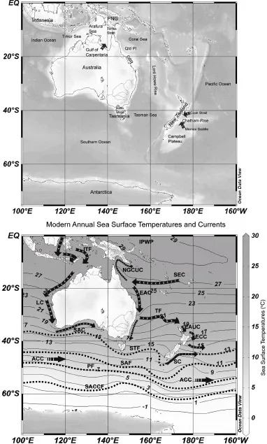
Figure 1.1 (Top) The location map of Australasia and the main oceanic features mentioned in the text. (Bottom) Primary ocean surface currents (arrows) and fronts (dashed lines) are shown with heavy lines while the thin black lines demarcate annual mean sea surface temperature isotherms. IPWP, Indo-Pacific Warm Pool; ITF, Indonesian throughflow; LC, – Leeuwin Current; SAC, South Australian Current; SEC, South Equatorial Current; NGCUC, New Guinea undercurrent; EAC, East Australian Current; TF, Tasman Front; EAUC, East Auckland Current; ECC, East Cape Current; SC, Southland Current; STF, Subtropical Front; SAF, Subantarctic Front; ACC, Antarctic Circumpolar Current; PF, Polar Front; SACCF, Southern Antarctic Circumpolar Current Front
The southern arm of the East Australian Current intensifies, accelerates, and deepens, following the Australian coastline until ~32°S (approximately Forster on Australia’s east coast) where it separates and flows east across the Tasman Sea to form the Tasman Front.11 It flows across the Tasman basin as a series of meanders, with most of the eastward flow concentrated between 33°S and 35°S (broadly the band between Swansea and the Beecroft Peninsula on Australia’s east coast).12 Minor flow, including the deeper layers of the East Australian Current, continues south of 32°S along Australia’s east coast as a series of deep eddies (Figure 1.1).13 This flow extends as far south as the Subtropical Front, which sits over the South Tasman Rise.
New Zealand
Northern New Zealand is influenced by warm subtropical waters that originate from the East Australian Current. This current flows into the New Zealand region along the Tasman Front, which curves around the east coast of the North Island where it forms the East Auckland Current and the East Cape Current (Figure 1.1). The flow in this current is complex and includes a series of eddies such as the semipermanent East Cape Eddy and Wairarapa Eddy just north of the Chatham Rise.14 The warm waters within this current are prevented from flowing south due to the Chatham Rise and are deflected eastward, forming a bounding current of the Subtropical Front. A small amount of warm subtropical water also flows around the south of New Zealand and heads north along the east coast of the South Island as part of the Southland Current, although this current is predominantly made up of cold subantarctic waters. The Southland Current is also deflected east along the south Chatham Rise at 44°S (south of Banks Peninsula).15
Southern Ocean
The northern boundary of the Southern Ocean is the Subtropical Front, which separates warm, salty, nutrient-poor subtropical waters in the north, from fresh, cool, nutrient-rich, subantarctic surface waters in the south.16 The Subtropical Front is characterized by steep temperature, salinity, and nutrient gradients in the upper 200 m (Figure 1.1) and can range from a narrow transition zone to a much broader region.
The position of the Subtropical Front can vary seasonally in some regions due to westerly wind changes. Over the South Tasman Rise, the Subtropical Front oscillates between 45°S and 47°S in winter and summer, respectively.17 Around the south and east of New Zealand, the position of the Subtropical Front does not vary, as it is chiefly constrained by the bathymetry of the Macquarie Ridge and the Chatham Rise.18
The main current of the Southern Ocean is the Antarctic Circumpolar Current, which flows clockwise around the Antarctic continent. The Antarctic Circumpolar Current is driven by strong westerly winds between 45°S and 55°S.19 The Antarctic Circumpolar Current is bound to the north by the Subantarctic Front and to the south by Southern Antarctic Circumpolar ...
Table of contents
- Cover
- Title
- Introduction Climate, Science, and Colonization: Histories from Australia and New Zealand
- Part I Frames, Events, and Responses
- Part II Debating Human Effects
- Part III Climate Understandings
- Epilogue: Future Research Directions
- Index
Frequently asked questions
Yes, you can cancel anytime from the Subscription tab in your account settings on the Perlego website. Your subscription will stay active until the end of your current billing period. Learn how to cancel your subscription
No, books cannot be downloaded as external files, such as PDFs, for use outside of Perlego. However, you can download books within the Perlego app for offline reading on mobile or tablet. Learn how to download books offline
Perlego offers two plans: Essential and Complete
- Essential is ideal for learners and professionals who enjoy exploring a wide range of subjects. Access the Essential Library with 800,000+ trusted titles and best-sellers across business, personal growth, and the humanities. Includes unlimited reading time and Standard Read Aloud voice.
- Complete: Perfect for advanced learners and researchers needing full, unrestricted access. Unlock 1.5M+ books across hundreds of subjects, including academic and specialized titles. The Complete Plan also includes advanced features like Premium Read Aloud and Research Assistant.
We are an online textbook subscription service, where you can get access to an entire online library for less than the price of a single book per month. With over 1.5 million books across 990+ topics, we’ve got you covered! Learn about our mission
Look out for the read-aloud symbol on your next book to see if you can listen to it. The read-aloud tool reads text aloud for you, highlighting the text as it is being read. You can pause it, speed it up and slow it down. Learn more about Read Aloud
Yes! You can use the Perlego app on both iOS and Android devices to read anytime, anywhere — even offline. Perfect for commutes or when you’re on the go.
Please note we cannot support devices running on iOS 13 and Android 7 or earlier. Learn more about using the app
Please note we cannot support devices running on iOS 13 and Android 7 or earlier. Learn more about using the app
Yes, you can access Climate, Science, and Colonization by Emily O'Gorman,Matthew Henry, J. Beattie in PDF and/or ePUB format, as well as other popular books in History & Asian History. We have over 1.5 million books available in our catalogue for you to explore.