![]()
Part I
Middle Ground
![]()
CHAPTER 1
Looking Like a White Man
Geopolitical Strategies of the Iowa Indians during American Incorporation
David Bernstein
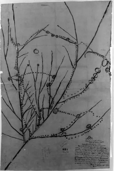
IN THE winter of 2007, ninety-one thousand people visited an innovative exhibit at the Field Museum in Chicago that explored the history of maps and mapping around the world. Midway through the exhibition, these visitors would have come across one of the most uncommon maps ever created (see fig. 1.1). Named after the Iowa Indian leader who presented it to Secretary of War Joel Poinsett in 1837, Notchininga’s Map is unique for a number of reasons. First, it is one of a handful of artifacts that remain from a time and place in which Native spatial knowledge was primarily transmitted orally. Graphic aids—sketches drawn in the sand or ceremonial performances—generally lasted only a few hours or until the next steady rain. Second, unlike most other examples of North American Indian cartography that were created explicitly as navigational aids, Notchininga’s Map represents a more generalized spatial construction, allowing us a slightly larger window into the worldview of its creator(s).1
The map depicts the river systems of a large section of what is now considered the upper Midwest of the United States, and with it, the historical migration of the Iowa people and the villages they had occupied since the fifteenth century. A dotted line begins near present-day Green Bay, Wisconsin, and continues south to the Iowas’ village on the Wolf River where they lived in 1837 when they presented the map to the Americans. “This is the route of my forefathers,” Notchininga stated at the meeting. “It is the land we have always claimed from old times—we have always owned this land—it is ours—it bears our name.” Unfortunately, according to the accompanying label, the map “failed to allay the pressure from either other Native Americans or white settlers, and the Ioway were further displaced to Kansas and Oklahoma.” At first glance, then, the map seems to be a graphic distillation of what we have come to expect from nineteenth-century Indian-white relations; Native assertion of ancestral territorial claims violently subsumed in an incompatible “clash of cultures,” resulting in Indian displacement and dispossession.2
Fig. 1.1. Nothcininga’s Map, 1837, Size of the Original 41 x 27 inches. Courtesy of the National Archives and Records Administration, Cartographic and Architectural Branch, Washington, D.C. RG 75, Map 821, Tube 520.
Yet first glances are deceiving. What appears to epitomize a traditional narrative of antagonistic “Indian” and “white” worldviews in fact confounds such simple categorizations. Notchininga’s Map was part of larger set of social and political tactics the Iowas employed that cannot be placed into such binary categories. Faced with declining wildlife resources and the continued encroachment of more-powerful Indian neighbors, the Iowas in the 1820s began reshaping the economies toward what they hoped would be a more stable agricultural future. At the same time, they adopted new geopolitical strategies aimed at gaining support from American representatives, most notably conscientious appropriation of Euro-American territoriality and cartography. By creating a document in the discourse understood by the colonizing culture, a Ptolemaic map drawn on paper, the Iowas distanced themselves from other native groups. Rather than a dichotomous vision of Indian-white relations, Iowa leaders understood that their communities had potentially much to gain from aspects of white expansion. They met with Secretary of War Poinsett and other American officials to mitigate their recurring and immediate tensions with powerful Indian adversaries. The primary purpose of this article, therefore, is to look beyond circumscribed definitions of Indian-white relations by highlighting this new strategy and to explore how the Iowas used diplomatic—most significantly cartographic—tactics to help shape their rapidly changing world. In so doing, I suggest a new evidentiary source for a growing number of scholars who have gone beyond traditional narratives in which Indians are forced to choose between the extremes of “acculturating to” or “resisting” American westward expansion.3
In addition to illuminating specific geopolitical maneuvers made by the Iowas, by highlighting the Indians’ appropriation of certain aspects of Euro-American territorial constructs, I address a larger issue within the study of Native American cartography. Though there has been no lack of interest in the map—in addition to the exhibit, it has been reproduced in at least six scholarly and popular works, including volume 2 of the seminal work of David Woodward and G. Malcolm Lewis, The History of Cartography—it has received limited historical analysis. While non-Native maps have come under close post-structuralist scrutiny as documents that contain political and social agendas particular for a historical moment, indigenous maps have been viewed as “authentic” cultural snapshots; pure representations of how a group of Indians understood their spatial existence. Thus, while virtually all of the pieces have noted the similarities between the map and modern, scientific depictions of the region’s hydrography—a “western” projection is unique among Native maps—scholars have simply accepted this irregularity as a characteristic of Iowa spatial constructions. This paper argues that extant examples of Indian cartography, including Notchininga’s Map, contain the same hidden agendas as their Euro-American counterparts and must be considered in the same deconstructionist light if we hope to fully grasp their historical significance. In other words, in order to understand the importance of Native maps, we must do what we do with any document; consider it in the context in which it was created.4
Native Mapping in Historiographic Context
Since the 1970s, historians of cartography have utilized the ideas of Michel Foucault, Jacques Derrida, Edward Said, and Anthony Giddens to resituate the map as a form of discourse that contains power, rhetoric, and value, rather than as an objective representation of reality. Two articles by J. Brian Harley exemplified this epistemological shift. In “Deconstructing the Map,” Harley called for the examination and acknowledgment of “the omnipresence of power in all knowledge, even though that power is invisible or implied, including the particular knowledge, encoded in maps and atlases.” A “deconstruction” must occur whereby the map is examined within broader movements and structures. In this way, the rhetoric of maps will become much more apparent. Stating simply that “cartographers manufacture power,” Harley concluded that the map’s most important rhetorical function lies in its subjectivity.5
A second article by Harley more explicitly explored the political power contained within maps. Building on the premise that maps need to be understood within the larger family of value-laden images, Harley explored how maps facilitated the geographical expansion of political systems. Tying map creation into other imperial processes such as military expansion and exacting taxation, Harley determined that cartography was (and remains) a “teleological discourse, reifying power, reinforcing the status quo, and freezing social interactions within charted lines.” And unlike music, art, or other expressions employed by those without alternative forms of resistance, maps have almost exclusively been used as a form of oppression by those in power. Thus, Harley argued, mapping’s “ideological arrows,” flew only in one direction.6
Though some criticized Harley’s approach for its designation of maps as texts (which disregards the process of map creation), scholars began to follow Harley’s lead by exploring maps’ hegemonic functions—the way in which colonizing powers gain and maintain control—in specific historical circumstances.7 In 1992, for instance, Gregory Nobles published an article in the Journal of American History that focused on mapping as a form of spatial control in colonial America. Examining the political order of the “Anglo-American Frontier,” Nobles proposed that Euro-Americans established political and social boundaries well before actual settlement patterns. By creating what appeared to be a priori plans of what the North American interior looked like, Anglo-American mapmakers established a vision of future dominance. Nobles states, “By drawing lines across the continent and imposing themselves in print, they literally mapped out a New World order.” Nobles’s article was accompanied by explorations into the hegemonic function of maps in a variety of colonial settings.8
At the same time that scholars were examining maps as tools for colonial and imperial powers, there was a resurgence in the study of maps made by Native North Americans. Led by G. Malcolm Lewis and followed by such scholars as Richard Ruggles, Barbara Belyea, and Gregory Waselkov, this group used post-structuralist models to investigate indigenous maps on their own terms. Rather than immature versions of the measured, mathematical spatial representations of European scientific cartography, these scholars viewed Native maps as sophisticated cultural documents that revealed an entirely different understanding of the world around them than those created by contemporary Euro-Americans. This new understanding of Indian maps has led to reexaminations of Lewis and Clark’s expedition, land transfers in colonial New England, and Spanish explorations of the American Southeast, to name just a few examples.9
As scholars revisit documents long dismissed as having little evidentiary value, three related lines of inquiry have emerged: (1) evaluating and comparing Native American spatial constructions; (2) exploring these constructions’ influence on maps made by Euro-Americans and their incorporation into imperial territorial appropriation; and (3) Native American maintenance of indigenous spatial constructs in the face of colonial oppression.10 A fundamental premise running through all three explorations is the belief that we can identify and isolate epistemologically unique forms of indigenous spatial knowledge.
G. Malcolm Lewis has argued, for example, that all Native maps created after 1925 can at best be considered as “pidgins,” as they have been “too acculturated” to afford evidence of “traditional forms.” Scholars such as Keith Basso and Hugh Brody—whose work documents the continued use of Native place-names—would no doubt refute Lewis’s assertion that contemporary Indian spatial and territorial constructions are “pidgins,” but they would certainly agree with his underlying premise of the existence of a uniquely Indian way of interacting with and representing geographical knowledge. Barbara Belyea goes so far as to say that not only are Indian and Euro-American constructions of space and place different, but “there is no ‘common ground.’ . . . Instead of continuing to translate the native cartographic convention into our own, we must acknowledge a gap between these conventions is essentially unbridgeable.” Thus, while there has been considerable—and sometimes heated—debate about the definition and characterization of Indian mapping, this divisive rhetoric has masked a common assumption: Native constructions of space, and their representations, are inherently different from Euro-American constructs.11
While the existence (or lack) of an epistemologically indigenous worldview is beyond the scope of this paper, I will demonstrate how an unconditional acceptance of such a view limits our understanding of Native cartography.12 By essentializing Indian spatial understanding to either a knowable or unknowable “other,” we are continuing the practice of idealizing Indian knowledge as something that lies outside of history. While historians and anthropologists have generally gone beyond the segregation of ethnology and history, most cartographic scholars have maintained strict intellectual boundaries around Indian maps, considering them ahistorical cultural documents.13 For example, the 131-page entry on “Native North American Maps” in The History of Cartography considers nothing beyond the cultural characteristics of Indian maps. The volume on Renaissance mapping, on the other hand, has separate sections for the political economic, military, and religious contexts of maps made in Italy, Portugal, Spain, German lands, Low Countries, France, the British Isles, Scandinavia, East-Central Europe, and Russia.14 I argue that without taking the historical context into consideration—the specific political, economic, and social circumstances in which a particular map was created—we relegate the creators of Indian cartography to a timeless distant past rather than taking them seriously as historical actors.
There have been a number of works that have astutely examined the political context of Indian mapping. Yet these pieces have invariably reified a dichotomous vision of Native and white concepts of space by exploring how Indians, either consciously or not, used their constructs to maintain “Indianness” in the face of colonial hegemony.15 In so doing, these studies limit our historical analyses to the well-worn path of cultural continuity. By placing Notchininga’s Maps in a particular historical moment, within a specific geopolitical landscape, we can continue to move beyond the Native/non-Native binary to explore the various ways the Iowas shaped their rapidly changing world. It is to this geopolitical landscape we now turn.
The Challenges of Imperial Incorporation and a New Political Alliance, 1700–1815
Throughout the eighteenth century, the Iowa Indians lived in semipermanent villages in present-day Iowa and Kansas, co...