On 21 August 2011, at 3:53 p.m., a tornado hit the town of Goderich, Ontario.
The scale used to measure the intensity of tornadoes is called the Fujita scale, which ranges from F0 (weakest at 110 kilometres per hour) to F5 (strongest at 450 kilometres per hour). Ninety percent of the tornadoes in Ontario register as F0 or F1 on the Fujita scale.
The tornado that hit Goderich was rated F3 by Environment Canada, with peak winds between 250 and 320 kilometres per hour. The last time that a tornado of this intensity was reported in Ontario was in 1996. Environment Canada was able to provide a fifteen-minute warning to the town before it hit (Rotteau 2011).
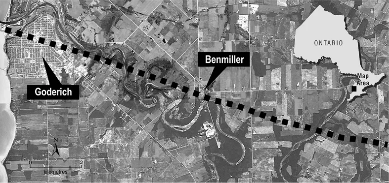
The path of the tornado was nineteen kilometres long. At the widest point, the path was 1.5 kilometres wide. The tornado was on the ground for fourteen seconds. People in town at the time said that it sounded like a train.
GODERICH, HURON COUNTY
Huron County is an agricultural region that had a population of 59,100 in 2011 (Statistics Canada 2011a). The Huron County population is characteristic of the population in rural Ontario and was stable or growing slightly from 52,951 in 1971 to 59,100 in 2011 (Statistics Canada 1972, 2011b). Since 1996, the Huron population has declined by 1.8 percent, from 60,220 in 1996 to 59,100 in 2011 (Statistics Canada 2001b).
The rural nature of Huron County means that 60 percent of its population live on a farm or rural property (Huron Business Development Centre 2010). Goderich is the largest town in Huron County, with a population of 7,521 in 2011 (Statistics Canada 2011a). Its population has been stable over the past several census periods (Statistics Canada 2001a). The Goderich population (median age of 48.5 years in 2011) is older than the Huron County population (median age of 46.0 years) and the provincial population (median age of 40.4 years) (Statistics Canada 2011a, 2011b).
Goderich, located on the shore of Lake Huron at the mouth of the Maitland River, is the county seat. The proximity to Lake Huron makes Goderich a popular tourist destination through the summer months. The Goderich harbour is the only deep-water commercial port on the east side of Lake Huron (Goderich Port Management Corporation 2013) and is home to the Sifto Salt Mine. Although manufacturing is important to the local economy, the sector suffered a significant blow in 2010 when Volvo Construction Equipment relocated a grader-manufacturing facility to the United States, with a loss of about 500 jobs.
The town boasts a unique street plan designed by John Galt when Goderich was founded in 1850 (Planning Partnership 2012). The downtown core, referred to as “The Square,” is an octagon with Court House Park in the centre. Like most downtown areas in rural Ontario, The Square has been experiencing pressure from highway commercial development.
THE 2011 GODERICH TORNADO
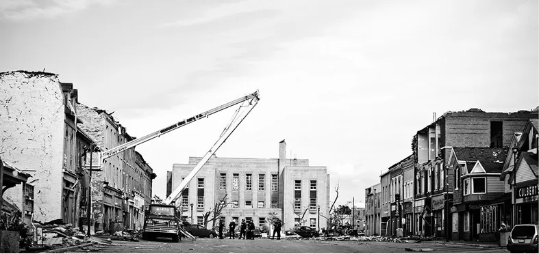
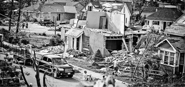
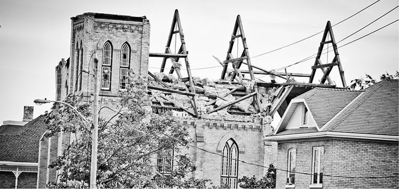
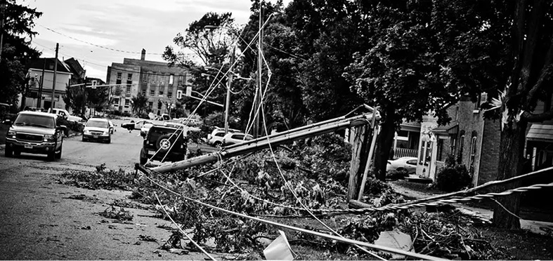
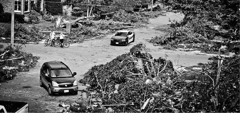
The destruction left behind by the tornado was immense. In its wake, there was one fatality, and thirty-seven people were injured. Mature trees were uprooted and broken, hydro poles were snapped like matchsticks, hydro wires were snaking over the ground, people’s homes were missing roofs. Walls were gaping open, leaving houses resembling life-sized dollhouses. Many buildings in the core area of town were damaged beyond repair. Everywhere there were piles of debris—trees and branches in full leaf, remains of buildings, walls, roofs, siding.
The Goderich Building Department (2012) issued thirty-eight residential demolition permits and twenty commercial demolition permits following the storm. The tornado’s path is shown in Figure 1.6. As it continued past Goderich, the tornado damaged sixty-six properties and destroyed 200 acres of woodlot (Huron County Planning Department 2012).
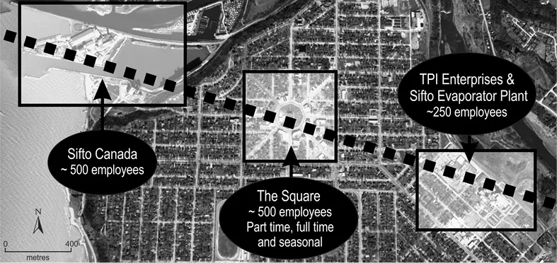
The tornado was destructive not only in its force but also in its route. It directly hit three significant areas of employment: the Sifto Salt Mine at the harbour (488 jobs), the downtown core (839 full-time and part-time retail and office jobs), and an industrial area in the northwest end of town (approximately 250 jobs) (see Figure 1.7) (Armstrong 2013; Howe 2013).
The scientific community reports that there are not adequate data to indicate whether there has been an increasing occurrence of tornadoes as a result of climate change (Hoerling 2011; Solomon et al. 2007). Although tornadoes might not be characteristic of extreme weather events associated with climate change, they do represent the type of unpredictable event expected to become more frequent in the future. For this reason, the 2011 Goderich tornado is considered a case study to discuss the resilience of rural Ontario communities in anticipation of more frequent severe and unexpected events such as those associated with climate change and peak oil.
Figure 1.1. Looking east on West Street at the County Courthouse, Goderich
Figure 1.2. St. Patrick Street and Arthur Street, Goderich
Figure 1.3. Victoria Street United Church, Goderich
Figure 1.4. Damaged trees and hydro wires in Goderich
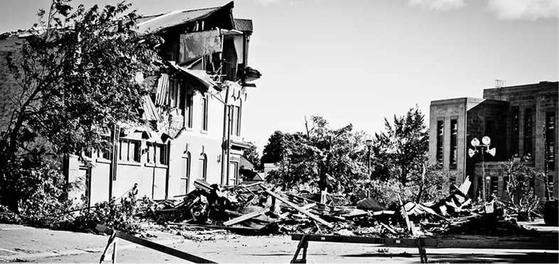
Figure 1.5. Surveying the damage after the tornado in Goderich
Figure 1.6: Path of 2011 tornado outside Goderich
Figure 1.7: Path of 2011 tornado within Goderich
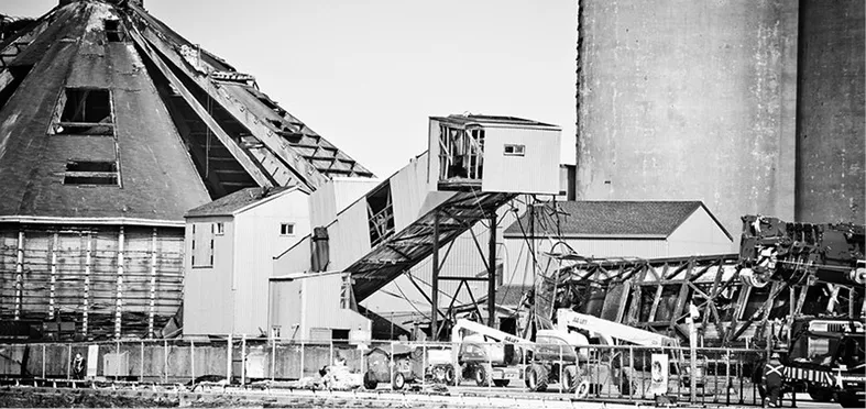
Figure 1.8. Damaged buildings at Sifto Salt Mine, Goderich
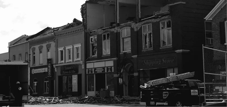
Figure 1.9. Damaged buildings on West Street, Goderich
This chapter offers frameworks for understanding transformation in socio-ecological systems and looks to the experience of the 2011 Goderich tornado to consider community resilience in response to an unpredicted catastrophe. Following the Goderich tornado case study, two community development efforts in Huron County are considered to provide more general observations about building community resilience in rural Ontario: the Huron Water Protection Steering Committee and Take Action for Sustainable Huron.
DEFINING RESILIENCE
Resilience means the ability of a system to withstand stress and recover to a similar state (Ferguson and Lapierre-Fortin 2012; Taleb 2012). The concept of resilience is found in many different areas of literature. It originated in the ecological literature but is an important idea in the public health, mental health, disaster response, socio-ecological, community development, natural resource management, and climate change literature (Gallopin 2006, in Ferguson and Lapierre-Fortin 2012). Resilience theory provides a dynamic, systems-oriented framework that is transferrable to any type of system—person, household, neighbourhood, business, farm, institution, forest, ecosystem, town, community, et cetera (Nelson, Adger, and Brown 2007). More discussion is provided in this chapter to conceptualize transformation and resilience in systems.
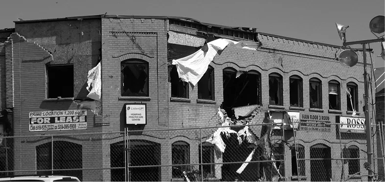
Figure 1.10. Damaged buildings in The Square, Goderich
Figure 1.11. Damaged buildings at the corner of Kingston Street and The Square, Goderich
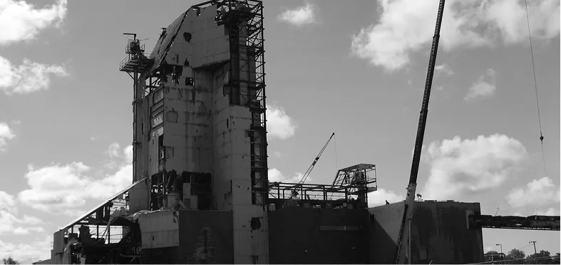
Figure 1.12. Sifto Evaporator Plant, Goderich
COMMUNITY RESILIENCE IN GODERICH
Adaptive capacity refers to the social and physical resources within a system that influence that system’s ability to adapt. It is a core characteristic of a resilient socio-ecological system (Nelson, Adger, and Brown 2007). Wall and Marzall (2006) have provided a framework to characterize the resources that define the adaptive capacity of a co...