The mysterious and remarkable ways that animals navigate
We know that animals cross miles of water, land, and sky with pinpoint precision on a daily basis. But it is only in recent years that scientists have learned how these astounding feats of navigation are actually accomplished. With colorful and thorough detail, Nature's Compass explores the remarkable methods by which animals find their way both near home and around the globe. Noted biologist James Gould and popular science writer Carol Gould delve into the elegant strategies and fail-safe backup systems, the invisible sensitivities and mysterious forces, and incredible mental abilities used by familiar and rare species, as they investigate a multitude of navigation strategies, from the simple to the astonishing.
The Goulds discuss how animals navigate, without instruments and training, at a level far beyond human talents. They explain how animals measure time and show how the fragile monarch butterfly employs an internal clock, calendar, compass, and map to commence and measure the two-thousand-mile annual journey to Mexico—all with a brain that weighs only a few thousandths of an ounce. They look at honey bees and how they rely on the sun and mental maps to locate landmarks such as nests and flowers. And they examine whether long-distance migrants, such as the homing pigeon, depend on a global positioning system to let them know where they are. Ultimately, the authors ask if the disruption of migratory paths through habitat destruction and global warming is affecting and endangering animal species.
Providing a comprehensive picture of animal navigation and migration, Nature's Compass decodes the mysteries of this extraordinary aspect of natural behavior.
Trusted by 375,005 students
Access to over 1.5 million titles for a fair monthly price.
It was a navigator’s worst nightmare. Shortly after midnight on a cloudy September night in the middle of the North Atlantic, the ship was suddenly attacked. Out of nowhere the screeching and wailing ghosts of long-dead sailors swept through the rigging, terrifying the superstitious seamen and drowning the captain’s shouted orders. The panicking crew knew instantly that they had trespassed on the infamous Isles of Devils, haunted by the souls of the thousands of crewmen who had perished on the treacherous shoals. But by the navigator’s reckoning, they were far to the west of the legendary death trap.
Within minutes, though, over the din came the fatal sound of waves breaking on a lee shore to the east. Turning the ship and piling on sail was their final mistake: the keel ran hard into one of the lethal coral reefs that ring the islands. The ship sank almost immediately, joining countless others that had suffered the same fate in that graveyard of the Atlantic that is the Bermudas. What had gone wrong?
Long-distance navigation is a life or death challenge for many nonhuman animals as well; the difference is that they know what they are doing. Few sights are more impressive to earthbound people than an isolated formation of geese passing overhead on their way to distant summer or wintering grounds. Theirs is not a journey on a wing and a prayer: all but first-year birds have a detailed map of the route in their brains, complete with remembered landmarks for piloting. After dark in the spring and fall literally billions of songbirds traverse the skies each night unseen, often to destinations hundreds or thousands of miles away. Unlike waterfowl, these passerines are using multiple compasses and a mystical GPS sense to find their way. At least 30 species would have been passing overhead on that fatal night in the Atlantic, maintaining their steady course for 2300 miles from Nova Scotia to South America.
Animals were on the move in the surrounding waters of the North Atlantic as well, racing against time to reach new habitats as the seasons changed. Humpback whales migrate past Bermuda on thousand-mile journeys with maps and compasses adapted to the gloom of the ocean. Many fish and sea turtles are similarly equipped for equally monumental seasonal redeployments. Below them on the seafloor spiny lobsters prance in tandem lines on arduous journeys, knowing their location in the cold darkness to within a few feet.
On a more local scale, honey bees and many other insects on the Bermuda islands, as elsewhere, commute scores of times each day from home to sources of food, water, or building materials, using a series of backup compasses and learned landmarks. Relative to their small body size and myopic vision, these trips are nearly as epic as those of geese, and each journey is a life-or-death event. Nesting birds on this mid-Atlantic refuge log many hundreds of miles shuttling back and forth first to collect nest material and then food for their young; getting lost would mean starvation for the next generation. Mice do much the same on the ground, but must employ a different set of cues and processing strategies more suited to running mazes than finding distant continents. Monarch butterflies flutter 2000 miles south from the United States and Canada to a remote mountain peak in Mexico, orienting by the ever-moving sun and a mysterious sense of location.
Faced with what is to us an alien task in an unforgiving world, humans stand in awe of the judgment and precision with which animals use cues—often undetectable by us—that are frequently ambiguous and ephemeral. We must depend on luck as much as talent, trying with clumsy approximations to replicate the compass sense that animals use innately to work out the rules of piloting and mapping, and to pinpoint our position on the globe without the seemingly magical combination of sensory abilities and inborn processing circuits that for other species comes as standard equipment. The navigators whose ships came to grief on Bermuda’s reefs were, in fact, employing an amalgamation of generally reliable animal strategies. What went wrong for that ill-fated ship beset by devils?
When Fernandino deVerar set sail in his well-armed, two-masted, 300-ton Portuguese merchant ship San Antonio in 1621, he understood the risks. He had sailed that spring from Cadiz in southwestern Spain for Cartagena in what is now northern Colombia with a load of goods for the American colonies. Like all human navigators of the time he was unable to judge his east–west position (the longitude) when out of sight of charted land, so his ship had sailed south with the northern coast of Africa clearly visible to larboard (the left, or port, side of the ship). He had abandoned this piloting strategy once his collection of instruments, charts, tables, and measurements of the sun’s elevation combined to tell him he was 12° north of the equator—roughly the latitude of his destination 3000 miles on the other side of the Atlantic. Then deVerar had turned west and, using a magnetic compass, sailed along this latitude until he reached the Caribbean. This vector strategy is similar to the way many migrant songbirds navigate their first season, before they learn enough to plot routes that incorporate the subtle realities of spherical geometry.
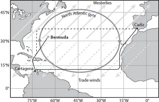
Journey of the San Antonio. The ship left Cadiz with a following wind and sailed south along the African coast to the latitude of Cartagena. Then it used the trade winds and the North Atlantic gyre to propel it to the Caribbean. The return voyage was to take it north to the latitude of Cadiz, then east with the westerlies and gyre at its back to Cadiz (dashed line). Unable to measure its longitude, the vessel in fact drifted east and ran aground on the reefs of Bermuda. (The rectangular projection used here exaggerates east–west distances at higher latitudes.)
Going south before “westing” to the New World allowed sailors to take advantage of the trade winds, which blow generally from the northeast in the northern tropics. The resulting “broad reach,” with the breeze coming diagonally from behind, extracts the maximum force from the wind. The ocean current at this latitude, part of the North Atlantic gyre, also provides a welcome two-mile-an-hour push to the west. Hundreds of species of migrating birds, sea turtles, and fish also know how to take advantage of these winds and currents.
The problem for sailors came with the return journey, their ships laden with treasure looted from Mexico and Peru. September is the height of the hurricane season in the Atlantic; the San Antonio, one of many vessels waiting in Cartagena, did not load her share of the booty until late August. It was a rich haul: thousands of hides, 6000 pounds of indigo, 30,000 pounds of tobacco, 5000 pounds of sarsaparilla, and 5000 English pounds worth of gold and silver. But there was not a moment to lose before bad weather set in.
Unfortunately deVerar and his convoy could not simply sail back east; that would take them into the teeth of the wind and current. Without wings or fins to propel them, they instead had to return to the gyre and sail north amid often contrary winds, piloting their way through the islands of the West Indies. The captain’s plan was to use his magnetic compass in a two-step strategy of vector navigation. The compass would allow him to bear north to the latitude of Cadiz and then (resetting his course to the east) let the westerlies and the gyre carry him across the Atlantic. As the San Antonio left the last of the well-charted Caribbean islands behind and plunged north toward her turning point at 36.5° north latitude, she necessarily lost track of her exact position.
The convoy depended on occasional sightings of the sun and stars for latitude; for longitude they had to rely on dead reckoning, a common procedure used by animals that we will look at in detail presently. This all-too-appropriately named strategy keeps track of approximate headings and speeds and times (with, in the case of humans, nothing more sophisticated than a compass, a knotted rope, and an hourglass), and then attempts to reconstruct location by integrating over the various legs of the journey. As with any bird or fish in the same situation, small errors in judging distance, direction, time, or velocity inevitably accumulate, making the resulting estimate ever less accurate. And once out of sight of land there is no way to factor in the drift induced by currents or wind. A sideways drift alters the actual direction traveled; a drift along the axis of travel—equivalent to a headwind or tailwind while flying—changes the distance covered.
The part of the gyre they were in as they left the Caribbean is notoriously unreliable. They might be in the center of the flow, being carried north or northeast at 3 mph; they might be a bit to the east in the Sargasso Sea, the huge calm eye of the gyre; or they might be in the Gulf Stream, which peels off unpredictably to the NE, warming Europe as it carries tropical waters to the British Isles. To make matters worse, the convoy was racing before a tropical storm, and had gone without a sighting of the sun or stars for some days.
By the first hours of September 12 deVerar’s ship was at 32.3° latitude, about 250 miles south of their intended right turn. Unaware of the branch current that was propelling the ship and with no celestial sightings (the clouds hid the first-quarter moon, which in any event had set at midnight), the navigator’s dead reckoning placed them about 50 miles south of his actual position—a harmless enough mistake on its own. The rest of the convoy, scatted by the storm, was about 20 miles behind and slightly to the west. Unfortunately, the San Antonio and the other ships also had drifted about 100 miles east of the northerly track they were trying to maintain, carried by a warm offshoot of the Gulf Stream. The tide was at its highest about 2 a.m., just covering the treacherous reefs.
Just ahead, the “devils” had taken wing about three hours earlier. Nocturnal gadfly petrels known as cahows spend their nights flying low over the water in search of squid, punctuating their hunting with loud, eerie screeching. The lights aboard the San Antonio had drawn them like moths as the ship pushed blindly NNE, just to the west of the islands that were home to the seabird colony. The terror inspired by the unearthly shrieking of the birds combined with the navigational incompetence of her human pilots and the shortcomings of their instruments to doom the ship.
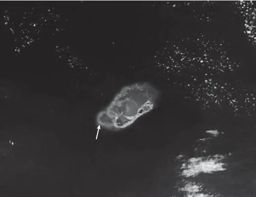
San Antonio’s track. This satellite view shows the chain of islands that make up Bermuda and (in light gray) the surrounding reefs, which are mainly to the west and north of the islands. The ship was sailing NNE, entering this picture in the lower-left corner and striking a submerged reef about two miles west of the mainland.
Unlike the sailors, the cahows are superb navigators. They seem to know their longitude to within a mile and their latitude with even better precision, clouds or no clouds. Their internal compasses are far more reliable than anything the hand of man could produce at the time. The islands were the birds’ breeding grounds; this was their one landmark in a sea empty for hundreds of miles, a beacon of safety rather than danger. And the cahows are by no means exceptional. The ocean around Bermuda is full of equally adept navigators, many of which know just where they are at any given moment. Green and loggerhead sea turtles, white-tailed tropicbirds, American eels, yellow-fin tuna, and humpback whales—none of these animal navigators are in danger of losing track of their position for long. Only our species earns this dubious distinction.
An animal’s ability to know its location and the direction of its goal is one of the greatest mysteries of science. Increasingly, though much remains to be discovered and understood, this ability seems less magical. Some of the mysteries are merely products of our opposing desires to romanticize behaviors on the one hand and oversimplify them on the other, and thus to look in the wrong places for answers. We also are prone to anthropomorphize, imagining that animals see challenges in the same way we do and use the same strategies to solve the problems they encounter. As a result, we have often overlooked some surprising alternative approaches that make complex tasks much simpler for well-programmed animals. In particular, we have assumed that our fellow creatures cannot measure orientation parameters any more accurately than human instrumentation, and ought in fact to do less well than our elaborate and expensive equipment.
Our plan is to look briefly at the range of orientation strategies evident in animals, from the simple to the astonishing. Because an essential component of many of these strategies is the ability to measure periods and intervals, we will examine time sense. The next most basic component is an array of alternative compasses to orient movement. We will then look at how time and compasses combine with memory to permit piloting and inertial navigation. This will lead us to the greatest challenge to human understanding, the map sense. With a fuller picture of how animals navigate, we will conclude with the imminent threats humans pose to navigators: habitat destruction and climate change.
As we will see, understanding animal navigation is often critical to conservation, and the recent gigantic steps in decoding the workings of the compass and map sense have come not a moment too soon. Consider the plight of the cahows, whose superb navigational skill and unearthly voices proved no defense against hungry colonists or their rats, cats, and rooting hogs.
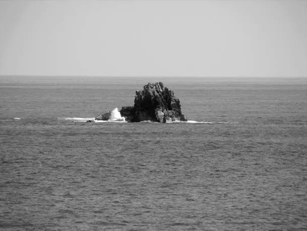
Gurnet Rock, off Bermuda. It was on a desolate islet like this, half a mile to the west, that the last colony of cahows clung to life. (The exact location of the refuge island remains a secret.)
The wholesale slaughter of the birds continued despite one of the earliest efforts at conservation, a 17th-century edict by the governor against the “spoyle and havocke of the Cohowes.” They were thought to be extinc...
Table of contents
Cover
Half title
Title
Copyright
Contents
Preface
Acknowledgments
1 Navigating—Problems and Strategies
2 When and Where
3 A Matter of Time
4 Insect Compasses
5 Vertebrate Compasses
6 Piloting and Inertial Navigation
7 The Map Sense
8 Migration and the Future: Conservation and Extinction
Bibliography
Illustration Credits
Index
Frequently asked questions
Yes, you can cancel anytime from the Subscription tab in your account settings on the Perlego website. Your subscription will stay active until the end of your current billing period. Learn how to cancel your subscription
No, books cannot be downloaded as external files, such as PDFs, for use outside of Perlego. However, you can download books within the Perlego app for offline reading on mobile or tablet. Learn how to download books offline
We are an online textbook subscription service, where you can get access to an entire online library for less than the price of a single book per month. With over 1.5 million books across 990+ topics, we’ve got you covered! Learn about our mission
Look out for the read-aloud symbol on your next book to see if you can listen to it. The read-aloud tool reads text aloud for you, highlighting the text as it is being read. You can pause it, speed it up and slow it down. Learn more about Read Aloud
Yes! You can use the Perlego app on both iOS and Android devices to read anytime, anywhere — even offline. Perfect for commutes or when you’re on the go. Please note we cannot support devices running on iOS 13 and Android 7 or earlier. Learn more about using the app
Yes, you can access Nature's Compass by James L. Gould,Carol Grant Gould in PDF and/or ePUB format, as well as other popular books in Biological Sciences & Ecology. We have over 1.5 million books available in our catalogue for you to explore.