A gripping journey through the icy regions of our changing planet
From the Arctic Ocean and ice sheets of Greenland, to the glaciers of the Andes and Himalayas, to the great frozen desert of Antarctica, The White Planet takes readers on a spellbinding scientific journey through the shrinking world of ice and snow to tell the story of the expeditions and discoveries that have transformed our understanding of global climate. Written by three internationally renowned scientists at the center of many breakthroughs in ice core and climate science, this book provides an unparalleled firsthand account of how the "white planet" affects global climate—and how, in turn, global warming is changing the frozen world.
Jean Jouzel, Claude Lorius, and Dominique Raynaud chronicle the daunting scientific, technical, and human hurdles that they and other scientists have had to overcome in order to unravel the mysteries of past and present climate change, as revealed by the cryosphere--the dynamic frozen regions of our planet. Scientifically impeccable, up-to-date, and accessible, The White Planet brings cutting-edge climate research to general readers through a vivid narrative. This is an essential book for anyone who wants to understand the inextricable link between climate and our planet's icy regions.

eBook - ePub
The White Planet
The Evolution and Future of Our Frozen World
- 328 pages
- English
- ePUB (mobile friendly)
- Available on iOS & Android
eBook - ePub
The White Planet
The Evolution and Future of Our Frozen World
About this book
Trusted by 375,005 students
Access to over 1.5 million titles for a fair monthly price.
Study more efficiently using our study tools.
Information
Publisher
Princeton University PressYear
2013Print ISBN
9780691173474
9780691144993
eBook ISBN
9781400844692
Topic
Physical SciencesSubtopic
Global Warming & Climate ChangePART ONE
THE WORLD OF ICE: PAST AND PRESENT
CHAPTER 1
The Ice on Our Planet
The temperature conditions that govern our planet are such that water can exist in three forms (vapor, liquid, and solid) in proportions that vary in different climate conditions. All of the water on the Earth makes up what is called the hydrosphere. Most water exists in liquid form, 97% of which is in the seas and oceans, which cover 360 million km2, or more than 70% of the planet’s surface. Freshwater, a vital resource found in the ground, lakes, rivers, and above all aquifers, represents only a small proportion of the total, a bit more than 0.5%; water vapor in the atmosphere amounts to .001%; and the water of the living world, the biosphere, represents much less.
Low temperatures are found in high altitudes and high latitudes; this is where ice forms. In current climate conditions, this ice represents only around 2% of the hydrosphere. How is that 2% distributed? How is it formed? What surface does it cover? What climatic role does it play? Before looking to the past, we will describe our white planet as it is now. Table 1.1 shows its main characteristics.
Snow and Ice: A Multifaceted World
When we think of ice, we immediately think of 0°C (or 32°F). This is the temperature at which water freezes and ice melts. It is a reference point for the temperature scale that we use in our everyday lives. In nature, it is a bit more complex because that temperature of reference involves only freshwater. In fact, because it contains salt, seawater freezes only below –1.8°C. And in certain circumstances, even very pure water does not easily become solid. This is the case with very small cloud droplets: they form from the condensation of water vapor and can remain in liquid form. Up to temperatures of –20°C, or even below, we then speak of supercooling. We should add that water vapor exists in the atmosphere regardless of the temperature; it can condense on microdroplets that form around condensation nuclei, and it also contributes to the growth of snow crystals by passing directly from the vapor phase to the solid phase.
Table 1.1.
Surface, volume, and contribution to the sea level of the different
components of the cryosphere.
components of the cryosphere.
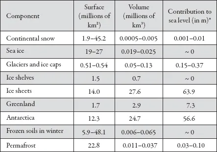
Source: IPCC, Climate Change 2007: Fourth Assessment Report (Cambridge: Cambridge University Press, 2007).
Note: In the case of snow, frozen ground in winter, and the permafrost, the minimum and maximum levels are given. For glaciers and glacial ice caps, the two levels correspond to high and low estimates.
* The melting of one million km3 of continental ice corresponds to a rise in sea level of 2.46 meters; the figures shown in this column take into account the replacement by seawater of the released surfaces below sea level.
There are different types of precipitation that reach the ground in solid form. Two are anecdotal within the framework of this book because, except in unusual cases, they melt quickly. Graupels (much like a fine hail) come from the freezing of raindrops that travel through air that is colder nearer the ground. Hail and hailstones are formed higher up in the atmosphere, within cumulonimbus clouds, which reach an altitude of over 10 kilometers. Snow is formed both through the freezing of small supercooled drops and by direct condensation of vapor on preexisting crystals. Unlike graupels and hail, a large part of snowfall remains in its frozen state as long as the temperature of the surface on which it falls is below 0°C.
The thickness and extent of the snow cover vary depending on the season. Permanent snow is, of course, found in the mountains, on glacial ice caps, and on sea ice. Outside those zones, snow covers on average 26 million km2, mostly on the continents of the Northern Hemisphere. At the end of January, that surface may reach 45 million km2 but reduces to less than 2 million km2 around the end of August. In the Southern Hemisphere, owing to the unfavorable distribution of the continents, snow fields cover scarcely more than .5 million km2. This snow cover is fairly thin, a fraction of a meter on average. It thus represents a very small volume of ice.
This is the snow that, year after year, over centuries and millennia, feeds our white planet, which we call the cryosphere. On the continents, mountain glaciers, glacial ice caps (a term used when the ice surface is less than 50,000 km2), and the huge ice sheets of Greenland and Antarctica are the main elements of the cryosphere. We must also include frozen ground, which is permanent in some places (permafrost), and other frozen grounds that are frozen only in the winter, such as rivers and lakes. There is also sea ice, which is formed by the freezing of ocean water surfaces; icebergs that float on the edges of ice caps and ice sheets; and ice shelves, fed in some peripheral regions of Antarctica by the ice that flows from the interior of the continent.
Mountain Glaciers and Ice Caps
Outside the high latitudes, it is above all the winter snow and the mountain glaciers that symbolize the white planet. In most regions, when it rains on the plains it snows in high altitudes. The height at which snow is permanent varies between about 3,000 and 4,500 meters depending on the latitude and the site’s orientation to the Sun. The density of the fresh snow cover is very low (0.1 to 0.2) because it contains a lot of air, which occupies the spaces left free between the complex lacy shapes of the snowflakes. The laws of thermodynamics dictate that these flakes will lose their edges through sublimation and assume a more spherical shape. This facilitates the piling of the layers whose density increases (more than 0.5 for the névé [snow that is more than a year old]). With recrystallization the smallest flakes disappear, giving way to the larger ones, and the amount of air captured between the crystals decreases. The ice thus formed has a density close to 0.9, the same as that made in a freezer. Both the névé and the ice then float on water. The amount of time required for these processes can vary considerably; it depends, for example, on the climatic conditions, the temperature, and precipitation. In the mountains, when the winter snow doesn’t completely disappear during the following summer, it becomes névé. The percolation of the melted water can lead to the formation of ice in a few years’ time.
There are approximately 160,000 such glaciers of all sizes. They are found on every continent except Australia. They cover some 430,000 km2, and the largest are found in Alaska, in the Canadian Arctic, in the South American Andes, and in the Himalayas. On the other end of the scale, some African glaciers measure only 15 km2. Among the longest glaciers are those of the Bagley Ice Field in Alaska (185 km), the Siachen in Karakorum (75 km), the Inybtehek in Tian Chan (65 km), the Uppsala in Patagonia (60 km), the Monaco in Spitzberg (60 km), the Tasman in New Zealand (28 km), and the Ngojumba in Nepal (22 km). Alpine glaciers cover around 3,000 km2. Half of them are in Switzerland, including the Aletsch Glacier, which measures 25 km in length; 10% of this surface is in France, including the Mer de Glace (Ice Sea) near Chamonix, which flows over 12 km. Contrary to what the name “mountain glaciers” might suggest, some, depending on the climatic characteristics of their location (precipitation, temperature), can flow as far as the sea: this is the case of the Malaspina (Alaska) and the Darwin (Chile) glaciers. They can become as much as several hundred meters thick.
We generally use the term glacial ice caps for glaciers whose surface can vary from a few thousand to 50,000 km2. They are found in high altitudes in polar and subpolar regions and are relatively flat. In Svalbard (Spitzberg), the largest ice cap found in the North-East Land extends over 8,000 km2 and is 300–400 meters thick. In Iceland, two ice caps (each 1,000 km2) cover the summit of the island, and the Vatnajokull (8,300 km2) is made up of 3,500 km3 of ice. Other ice caps are found in the Arctic, in the northern Canadian archipelago, in Siberia, and in southern Chile. There are approximately seventy of various sizes.
Glaciers and ice caps cover an area that is close to that of France; their volume amounts to between 50,000 and 130,000 km3. The area of the glaciers and ice caps located on the edges of Antarctica and Greenland, not taken into account in Table 1.1, represents 140,000 km2.
Polar Regions: The Omnipresence of the White Planet
Zero degree Celsius (0°C) in the middle of summer on the sea ice of the North Pole. Only nine days a year without frost in Resolute Bay (74° 43´ N, Canada) at sea level. A yearly average of –30°C at the center of Greenland at 3,000 meters in altitude. These figures provide the image of a region, the Arctic, where cold is the rule. On the other side of the planet, –11°C is the average temperature at the coastal base of Dumont of Urville (66° 07´ S) and –55.4°C in Vostok in the heart of Antarctica at 3,488 meters in altitude. And the temperature can plunge as low as –89°C in the winter. The polar regions hold unenviable records. The Sun has little love for them, and the feeling is mutual.
It is primarily the tilt of the Earth’s axis of rotation (23° 27´) compared to the plane of its trajectory around the Sun that is responsible for the fact that the Sun has little love for the polar regions and keeps them among the coldest places on the planet. This tilt, also called the obliquity, determines the length of the presence of the Sun as a function of the latitude and thus the rhythm of the seasons. In the summer, boreal or austral, above 66° 33´ in the north or the south, the Sun can be continuously visible, whereas at the opposite pole it is below the horizon for the six months of winter. In addition, in the polar regions the Sun’s beams never shine perpendicularly. For any given surface, the energy absorbed is that much more reduced. Thus the high latitudes, in terms of solar energy received, are at a disadvantage. As if annoyed by the lack of attention, the white planet that spreads out over the poles has chosen to ignore the Sun since it sends back up to 90% of its incidental rays over a zone covered with fresh snow. This albedo effect varies with the nature of the surface; it can go as low as 50% for old snow and, though it can be around 80% over a large part of the ice sheet, it varies over the sea ice from 80 to 50%, depending on the condition of the surface and how reflective it is. It is thus essential to wear sunglasses in these zones to avoid blinding because the eye knows the difference between an albedo of 80% and that of rocky surfaces (15 to 30%) or of ocean surfaces (5 to 15%). In terms of climate, it is the size of this albedo that is one of the main characteristics of snow and ice. Greatly reducing the absorption of solar rays that are already weak in the high latitudes, it is largely responsible for the extreme cold of these icy regions, both in oceanic and continental regions.
But the Sun and the albedo are not the only players. In high latitudes during the cold seasons the ocean is covered with a lid of ice. Without it, the Arctic Ocean, in the middle of which we find the North Pole (Figure 1.1), and the Southern Ocean, surrounding the Antarctic continent, transfer a large quantity of heat into the atmosphere, maintaining the temperature of the air close to that of the seawater. But when the ice cover is in place, the “ocean radiator” stops and the winter temperatures above the sea ice can reach –30°C or even lower. In the Arctic Ocean and the adjacent seas to the north, as well as in the Southern Ocean, it is common that, following summer, the temperature on the surface of polar waters is lower than –1.8°C, which means that the surface is cold enough to freeze into sea ice. The first ice crystals give birth to “pancake ice,” which, in time, forms sea ice. This process requires rather long periods of freezing because the surface water, when it is cooled, becomes denser; it sinks and is replaced by warmer water. After reaching a certain thickness, the ice isolates the ocean from the atmosphere and slowly builds up further by freezing of the colder seawater underneath the ice. Waves and swells slow down this formation of sea ice, which can become one to two meters thick in the first year. Over the years, and taking into account summer melting, it can then increase up to three to four meters.
Summer brings melting and partial dislocation but in very different ways in the two hemispheres. In the south, the sea ice attached to the continent is exposed to the whims of the Southern Ocean; it extends up to 17 to 20 million km2 in September—that is, to a surface equivalent to that of the entire Antarctic continent—and five times less in February, or 3 to 4 million km2. In the Arctic, the sea ice is surrounded by continental surfaces that stabilize it; it extends over 14 to 16 million km2 in March with ice that is a bit thicker than that around Antarctica. And, as we will see, it becomes three to four times smaller in September.
On continents with particularly harsh climates without glaciers, frozen ground, or permafrost, forms. When the average temperature goes below 0°C, ice is present at great depths. Mammoths and bison, dating from the last ice age, have been found in these natural freezers in Siberia and Alaska. Depending on the season, this ground can thaw on the surface, but the thickness of the permafrost can reach as deep as six hundred meters. The surface areas are also considerable in these regions: one quarter of the exposed land in the Northern Hemisphere including Alaska, Canada, and Russia but also certain regions in the high mountains are covered by permafrost. However, the zones with a great deal of ice scarcely cover 2 million km2. These permafrost zones can extend under seas and oceans, as well as under glacial ice caps and ice sheets.
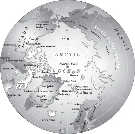
Figure 1.1. The Arctic regions, indicating the deep ice core drilling sites in Greenland.
One need only fly over Siberia in the winter to grasp the importance that snow has in the everyday lives of Russians. It’s not surprising that their language is particularly rich in terms describing snow in all its forms, nor is it surprising that they have bequeathed many expressions to us, including the word zastrougi to describe the very typical relief of the great expanses of snow as seen on the high plateaus of the ice sheets swept by winds. Zastroug is in fact an old Russian word that means “hand plane” (referring to the manual planing of wood), and sastrugi are the shapes on the surface of the snow that form through erosion and in the direction of the wind. Such shapes are similar to those that are seen on a plank that has been manually planed.
Greenland, Antarctica, and Ice Shelves
The largest and most voluminous glaciers are indisputably the inlandsis (“ice in the middle of land”) as they are called in Danish. They are on a completely different scale: one is in the north (Greenland) (Figure 1.1) and the other in the south (Antarctica) (Figure 1.2), home of the South Pole. These two enormous ice masses, which cover around 11% of the total surface of all continents, weigh heavily upon the Earth’s crust. They cover that crust and their weight pushes down the rock base by around 30%. Whereas Antarctica is more or less centered on the South Pole, Greenland is an island around 2,500 kilometers in length and located over latitudes of 60° and 80° N. Both have true rivers of ice that flow toward the sea in the form of emissary glaciers, or extend into the sea in the form of floating ice shelves, mainly in Antarctica. The profiles of the ice sheets are noticeably parabolic. On the relatively flat central parts, the wind sculpts little dunes that resemble those in dry deserts, the zastrougis. In the coastal zones, where the slope is greater and the ice currents marked, crevasses form that make it difficult to gain access to the inland ice sheets.
In Greenland, ice covers a surface of 1.76 million km2, or 80% of the total surface of the island, which with 40,000 kilometers of coastland is the largest in the world. The ice sheet makes up the largest part (1.7 million km2), to which are added glaciers and glacial ice caps located on the periphery and on coastal islands. The surface of the ice sheet is characterized by the existence of two domes, one in the south reaching 2,873 meters and one in the north at 3,236 meters. The dividing lines of the ice flowing to the coast depend on this asymmetry in altitude. There, toward the coast, myriad glaciers create paths through a discontinuous and low mountain chain. The widest is the Humboldt Glacier located in the northwest. The front is 120 meters high and 80 kilometers wide. These glaciers isolate the nunataks (“land in the middle of glaciers”). The largest and the most active is the Jakobshavn Glacier on the west coast, around 70° N. It drains the ice from the ice sheet over a length of more than 300 kilometers. The icebergs it releases invade the fjord that the glacier has dug, which, even in the summer, assures the presence of sea ice. The icebergs that come from the largest ice rivers are of modest size and relatively regular shape. The fjords,...
Table of contents
- Cover Page
- Title Page
- Copyright Page
- Contents
- Preface
- Part One: The World of Ice: Past and Present
- Part Two: Polar Ice: Amazing Archives
- Part Three: The White Planet Tomorrow
- Part Four: The Poles and the Planet
- Conclusion: The Anthropocene Era
- Notes
- Selected Bibliography
- Index
Frequently asked questions
Yes, you can cancel anytime from the Subscription tab in your account settings on the Perlego website. Your subscription will stay active until the end of your current billing period. Learn how to cancel your subscription
No, books cannot be downloaded as external files, such as PDFs, for use outside of Perlego. However, you can download books within the Perlego app for offline reading on mobile or tablet. Learn how to download books offline
Perlego offers two plans: Essential and Complete
- Essential is ideal for learners and professionals who enjoy exploring a wide range of subjects. Access the Essential Library with 800,000+ trusted titles and best-sellers across business, personal growth, and the humanities. Includes unlimited reading time and Standard Read Aloud voice.
- Complete: Perfect for advanced learners and researchers needing full, unrestricted access. Unlock 1.5M+ books across hundreds of subjects, including academic and specialized titles. The Complete Plan also includes advanced features like Premium Read Aloud and Research Assistant.
We are an online textbook subscription service, where you can get access to an entire online library for less than the price of a single book per month. With over 1.5 million books across 990+ topics, we’ve got you covered! Learn about our mission
Look out for the read-aloud symbol on your next book to see if you can listen to it. The read-aloud tool reads text aloud for you, highlighting the text as it is being read. You can pause it, speed it up and slow it down. Learn more about Read Aloud
Yes! You can use the Perlego app on both iOS and Android devices to read anytime, anywhere — even offline. Perfect for commutes or when you’re on the go.
Please note we cannot support devices running on iOS 13 and Android 7 or earlier. Learn more about using the app
Please note we cannot support devices running on iOS 13 and Android 7 or earlier. Learn more about using the app
Yes, you can access The White Planet by Jean Jouzel,Claude Lorius,Dominique Raynaud, Teresa Lavender Fagan in PDF and/or ePUB format, as well as other popular books in Physical Sciences & Global Warming & Climate Change. We have over 1.5 million books available in our catalogue for you to explore.