How high energy consumption transformed postwar Phoenix and deepened inequalities in the American Southwest
In 1940, Phoenix was a small, agricultural city of sixty-five thousand, and the Navajo Reservation was an open landscape of scattered sheepherders. Forty years later, Phoenix had blossomed into a metropolis of 1.5 million people and the territory of the Navajo Nation was home to two of the largest strip mines in the world. Five coal-burning power plants surrounded the reservation, generating electricity for export to Phoenix, Los Angeles, and other cities. Exploring the postwar developments of these two very different landscapes, Power Lines tells the story of the far-reaching environmental and social inequalities of metropolitan growth, and the roots of the contemporary coal-fueled climate change crisis.
Andrew Needham explains how inexpensive electricity became a requirement for modern life in Phoenix—driving assembly lines and cooling the oppressive heat. Navajo officials initially hoped energy development would improve their lands too, but as ash piles marked their landscape, air pollution filled the skies, and almost half of Navajo households remained without electricity, many Navajos came to view power lines as a sign of their subordination in the Southwest. Drawing together urban, environmental, and American Indian history, Needham demonstrates how power lines created unequal connections between distant landscapes and how environmental changes associated with suburbanization reached far beyond the metropolitan frontier. Needham also offers a new account of postwar inequality, arguing that residents of the metropolitan periphery suffered similar patterns of marginalization as those faced in America's inner cities.
Telling how coal from Indian lands became the fuel of modernity in the Southwest, Power Lines explores the dramatic effects that this energy system has had on the people and environment of the region.
eBook - ePub
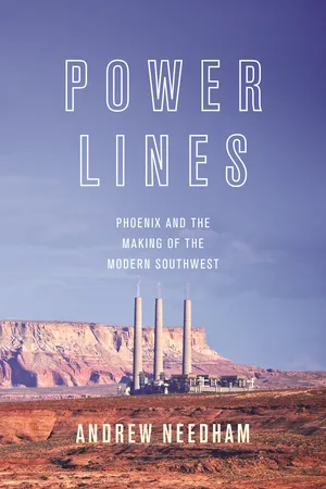
Power Lines
Phoenix and the Making of the Modern Southwest
- 336 pages
- English
- ePUB (mobile friendly)
- Available on iOS & Android
eBook - ePub
About this book
Trusted by 375,005 students
Access to over 1.5 million titles for a fair monthly price.
Study more efficiently using our study tools.
Information
Publisher
Princeton University PressYear
2014Print ISBN
9780691173542
9780691139067
eBook ISBN
9781400852406
PART I
Fragments
CHAPTER 1
A Region of Fragments
AT 7:36 P.M. ON OCTOBER 9, 1936, ELIZABETH SCATTERGOOD, THE daughter of the chief engineer of the Los Angeles Bureau of Power and Light, lowered “the most powerful fingertip in the world.” At that instant, telegraph wires carried a signal from Scattergood’s finger to the power-house at the base of Boulder Dam. Hearing the telegraph’s staccato alert, an engineer in the powerhouse threw a switch, opening circuits that sent electricity coursing through the power lines that surmounted the canyon walls downstream from the dam. An instant after Scattergood lifted her finger, sixteen arc lights on the top floor of City Hall burst to light, extending “long fingers of brilliance into the darkness,” in the words of an LA Times reporter. “The dim-lit city, starting up like a sleeper,” Thomas Treanor wrote, “was in an instant clothed with such a flaming radiance as man has never made before.” More than one million Angelinos flooded the streets in the city’s largest civic celebration since the Armistice. Addressing the throng, Mayor Frank Shaw promised benefits not only for his city, but for a far broader region. The dam’s power would trigger, Shaw announced, “a higher order of social and industrial development that will bring us happy results in the Southwest.”1
Boulder Dam had been an object of national fascination since its construction began five years earlier. Seven hundred fifty thousand annual visitors flocked to see the dam’s creation, thrilling at the high-scalers swinging from ropes hundreds of feet long and marveling at the massive buckets of concrete lowered to the dam’s rising crest, activity that formed a welcome contrast to the photos of bread lines and migrant labor camps that filled the nation’s newspapers in the Depression’s depths.2 Franklin Roosevelt’s secretary of the interior, Harold Ickes, certainly realized the dam’s potent symbolism. He was in office for less than a month before removing “Hoover” from the dam and replacing it with “Boulder.”3
Roosevelt realized its symbolic power too. In September 1935, as he began his reelection campaign, Roosevelt traveled to Black Canyon. With ten thousand spectators “fringing the parapet like pygmies,” as the Times reported, Roosevelt explained the dam as a manifestation of the transformations the New Deal had set in motion.4 “The largest generators and turbines yet installed in this country, machinery that can continuously supply nearly two million horsepower of electric energy,” Roosevelt explained, would soon “power factory motors, street and household lights and irrigation pumps.” In so doing, the dam’s energy would transform the region and the nation at large. No longer would the Southwest be known primarily as a land of “unpeopled, forbidding desert.” Its residents would no longer “dread the coming of a flood” or fear “a shortage of water” caused by the “turbulent,” “unpredictable” river. Instead, the dam would create industrial modernity, benefiting “the millions of people who now dwell in this basin, and the millions of others who will come to dwell here in future generations.” In closing the frontier stage of development in the Southwest, the dam promised to benefit the nation at large. “The mighty waters of the Colorado were running unused to the sea,” Roosevelt proclaimed. “Today, we translate them into a great national possession.”5
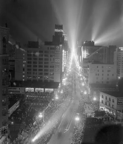
FIGURE 1.1. Los Angeles’s celebration of Boulder Dam’s electricity represented the largest civic celebration in almost twenty years. Copyright © Corbis. 1936.
The crowd gathered on the dam’s crest roared, but people elsewhere in the Southwest were less enthusiastic. Many Arizonans feared that the benefits Roosevelt outlined would be distributed far more unequally than he suggested. Since a 1922 interstate compact dividing the river’s waters had placed Arizona and California together in the Colorado River’s lower basin, California’s demand for water seemed an existential threat. A year before the dedication of Boulder Dam, Arizona governor Benjamin Mouer had declared martial law on the Arizona shore of the Colorado, deploying forty infantrymen and twenty machine gunners to Parker, Arizona, and dispatching the “Arizona Navy”—five state guardsmen aboard the ferryboat Julia B—to prevent federal workers from completing preliminary work on Parker Dam, which, downstream from Boulder, would divert the now controlled waters of the Colorado to Southern California. To Mouer, the planned aqueduct was little better than theft of Arizona’s rightful resources. “We may get licked in this affair,” Mouer proclaimed, “but we will go down fighting.” The Los Angeles Times dispatched a “war correspondent,” who archly reported on the mobilization of “troops into this theater of war to protect the State of Arizona from invasion by all or part of the State of California.” A member of the Arizona Navy took his anger out on California literally, firing a shotgun into the Colorado’s western shore. The incident ended in farce. The Julia B became entangled in cables cast across the river, and its sailors suffered the indignity of being rescued by a boat owned by the City of Los Angeles. The conflict moved to the Supreme Court, which enjoined further work on the dam before Congress settled the matter by passing the 1935 Rivers and Harbors Bill expressly authorizing Parker Dam. While it did not prevent the dam’s completion, the voyage of the Arizona Navy signaled the fears among many Arizonans that the development of the Colorado’s energy did not foretell shared regional and national growth. Rather, they saw competition in which Arizona’s needs were subordinated to those of California.6
The state capital in Phoenix was not the only place in Arizona where officials had reasons to fear Boulder Dam. In 1933, Commissioner of Indian Affairs John Collier spoke before the Navajo Tribal Council in Fort Defiance, Arizona. “Down there on the Colorado River,” Collier told the council, “is the biggest, most expensive dam in the world… which will furnish all southern California with water and power. The Boulder Dam will be filled up with your fine agricultural soil in no great number of years if we do not stop erosion.”7 Collier warned the council that the dam’s construction might lead other federal officials to identify erosion from the Navajo Reservation as a threat to regional development and national investment. Either Navajos could stop erosion voluntarily, Collier warned, or someone would do it for them. Attempts to control erosion, however, entailed new regulation of grazing land, new limits on herd sizes, and, more generally, the destabilization of the subsistence economy that had allowed Navajos to mount perhaps the most successful response to American conquest of any American Indian tribe.
The beams of light that lit Los Angeles, the Arizona Navy traveling up the Colorado River, and the warnings to the Navajo Tribal Council all reflected the Southwest’s fragmentation. Across Arizona and Southern California, human history had created something akin to “island communities,” to use Robert Wiebe’s description of late nineteenth-century America’s spatial form.8 Phoenix and the Navajo Reservation lay deeply connected to markets both national and global. They had little relation to each other, however. The construction of Boulder Dam, and the politics surrounding it, signaled a change. It suggested that efforts to turn the energy of the river to human purposes had begun to tie the fates of those places together. Boulder Dam had begun the creation of a new region.
ENERGY’S PAST
“As an unregulated river,” Franklin Roosevelt told the crowd at Boulder Dam, “the Colorado added little of value to the region this dam serves.”9 Flowing unimpeded to the Gulf of California, the Colorado’s history seemed to Roosevelt one of great waste, a story of productive resources left unclaimed. Natural energy has a productive history, however, that exists independent of human history. It wrote that past on the landscape that surrounded Boulder Dam. Indeed, the results of energy’s productive past enabled the productive future that Roosevelt’s dedication envisioned in the form of the walls that held Boulder Dam’s abutments and contained the upstream waters of Lake Mead.
The canyons of the Colorado were only one element of energy’s history. One hundred million years before crowds joined Roosevelt atop Boulder Dam, the location where they stood had been starkly different. Rather than a high plateau bisected by the deep canyons of the Colorado, the land was flat and swampy. It lay a mile lower than it would in the twentieth century, almost at sea level. Waters trickled slowly across the land, not west, toward the Pacific, but east toward a vast shallow sea that stretched across what is today the intermountain West.10 Plants grew thickly along the fluctuating shores of the Cretaceous Seaway. Ferns, palms, and cypress raised their leaves to the sun, gathering solar energy. Using photosynthesis, they converted that ephemeral energy into carbohydrates, which took form as stalks, branches, and leaves.11 When eaten by the triceratops or other dinosaurs that roamed the swamps, carbohydrates fueled biological life. Most carbohydrates, however, went unconsumed. Upon death, those plants sank into the swamp. They formed a thick mat of vegetation that decomposed slowly as bacteria harvested carbohydrates. Decomposing plants formed an oozy muck on the swamp floor where oxygen and bacteria grew scarce. Decomposition slowed. Sediment from inflowing rivers pressed from above, squeezing sap and other liquids from the ancient plants. Pressure also broke loose weakly bonded oxygen and hydrogen atoms from the carbohydrates, leaving mostly carbon behind. As they bonded in hexagonal rings, those molecules formed a dense substance known as peat.12
Peat represented a concentration of the energy prehistoric plants had stored. It will smolder steadily if lit. For decades, even centuries, burning peat beds will slowly release the energy of their bonded carbon until little but ash remains.13 Most of the peat in the prehistoric Southwest did not ignite, however. Instead, it slowly changed, assuming an even more energy-rich form. Additional pressure from overlying rocks and underlying geologic forces compressed peat, rendering it more and more carbon-rich as pressure broke all but the strongest chemical bonds. Peat first became a jellied substance the consistency of soft cheese, called gyttja, then it solidified. Slowly over aeons, prehistoric plants became bituminous coal.
Coal beds clustered in seams across present-day Arizona, New Mexico, Colorado, and Utah, mapping the Cretaceous Seaway’s ancient shorelines.14 Those coal beds stored ancient energy in place beneath the surface of the Colorado Plateau until humans discovered it, and more importantly, until they found it valuable and accessible. Those beds remained buried not only through the long history of geologic time, but through most of the shorter history of the industrial age. Lying far from industrial and urban centers, the Southwest’s coal remained buried while coal fired Manchester mills to produce cloth for a world market; while coal heated tenements to warm immigrants in New York, Philadelphia and Chicago; and while coal drove railroads across the American West. It remained buried until technology, demand, and politics made it accessible. Eventually, humans would claim ownership of the ancient energy that underlay the Colorado Plateau while debating whom these vast stores of natural wealth should enrich. No humans, however, had a hand in that wealth’s creation. It was the work of the sun, the earth, prehistoric life, and time itself.15
Unlike coal, water’s energy history does not sit in place. Instead, over aeons, it has created place. The Southwestern landscape that exists today, not only iconic sites like the Grand Canyon, but the vast valley of the Salt River and the thin soils of the Colorado Plateau, represent its creation.
The process by which water made new places in the Southwest began with the dramatic geologic changes that helped transform peat beds into coal seams. Seventy million years ago, the tectonic changes that caused the Rocky Mountains to rise from sea level dramatically transformed the lands to their west as well. Entire tectonic blocks rose steadily upward, like corks in water, forming the Coconino, Kaibab, and Colorado Plateaus.16 Over the course of forty million years, the Colorado Plateau, what today forms most of southern Utah, northern Arizona, and western New Mexico, rose more than a mile. Its location in the new geography of North America, sandwiched between the Pacific Ocean and the Rocky Mountains, meant that its landscape received the brunt of water’s energy as it exited the mountains in the spring melt seeking the ocean. Water rushing out of the mountains eventually established a common path, and a powerful river formed; explorer John Wesley Powell wrote in 1869, “a million cascade brooks unite to form a thousand torrent creeks; a thousand torrent creeks unite to form half a hundred rivers beset with cataracts; half a hundred roaring rivers unite to form the Colorado, which rolls, a mad, turbid stream, into the Gulf of California.”17
Powell witnessed a relatively young landscape, geologically speaking, when he journeyed down the Colorado in a flat bottomed boat in 1869. Geologists currently believe that, until eight million years ago, the water flowing out of the Rockies collided with the plateau lands to the west and turned south, flowing into a massive inland lake they have named Lake Bidahochi. At the same time, an ambitious stream to the west had been cutting its way through the Kaibab Plateau for millions of years. As the headwaters of that stream reached farther and farther east through a process called headwall erosion, they gathered more water, carving the channel wider and deeper. One momentous day, the stream broke through the plateau’s last redoubt and met the main stream of the prehistoric Colorado River. In a flood of unbelievable magnitude and duration, the Colorado changed course, choosing the stream’s steep gradient over the relatively level course toward the lake. Lake Bidahochi gradually drained, forming the bed of the Little Colorado River. At the same time, the Colorado’s water tore into the Plateau, digging deeper and deeper, and forming, over the past eight million years, the Grand Canyon.18
Similar canyons formed across the Plateau as the Colorado’s tributaries—the San Juan, the Virgin, and the Salt Rivers—cut their way through its land. Water’s energy dug canyons deep, isolating water and leaving the Colorado Plateau’s surface dry and arid.19 The steep slopes and thin soils on the Plateau created a landscape prone to erosion. And the river’s rapid current served as a conduit, carrying massive amounts of silt, soil, and sediment downstream from the Colorado Plateau. River gauges placed near Yuma, Arizona, in the early twentieth century, before dams impeded the river’s flow, estimated that the river carried 500,000 tons of reddish soil every day.20 Silt ran so thick in the Colorado that swimmers who ventured into its waters emerged with a strange second skin, a coat of silt that Barry Goldwater found in 1940, “dries as tight as a weiner skin and is about as comfortable.”21
Erosion left the Plateau’s soil thin. Most of its landscape varied between desert and grasslands. In locations where slickrock ...
Table of contents
- Cover Page
- Title Page
- Copyright Page
- Contents
- Acknowledgments
- Introduction: Beyond the Crabgrass Frontier
- Part I: Fragments
- Part II: Demand
- Part III: Supply
- Part IV: Protest
- Abbreviations of Sources and Collections
- Notes
- Index
Frequently asked questions
Yes, you can cancel anytime from the Subscription tab in your account settings on the Perlego website. Your subscription will stay active until the end of your current billing period. Learn how to cancel your subscription
No, books cannot be downloaded as external files, such as PDFs, for use outside of Perlego. However, you can download books within the Perlego app for offline reading on mobile or tablet. Learn how to download books offline
Perlego offers two plans: Essential and Complete
- Essential is ideal for learners and professionals who enjoy exploring a wide range of subjects. Access the Essential Library with 800,000+ trusted titles and best-sellers across business, personal growth, and the humanities. Includes unlimited reading time and Standard Read Aloud voice.
- Complete: Perfect for advanced learners and researchers needing full, unrestricted access. Unlock 1.5M+ books across hundreds of subjects, including academic and specialized titles. The Complete Plan also includes advanced features like Premium Read Aloud and Research Assistant.
We are an online textbook subscription service, where you can get access to an entire online library for less than the price of a single book per month. With over 1.5 million books across 990+ topics, we’ve got you covered! Learn about our mission
Look out for the read-aloud symbol on your next book to see if you can listen to it. The read-aloud tool reads text aloud for you, highlighting the text as it is being read. You can pause it, speed it up and slow it down. Learn more about Read Aloud
Yes! You can use the Perlego app on both iOS and Android devices to read anytime, anywhere — even offline. Perfect for commutes or when you’re on the go.
Please note we cannot support devices running on iOS 13 and Android 7 or earlier. Learn more about using the app
Please note we cannot support devices running on iOS 13 and Android 7 or earlier. Learn more about using the app
Yes, you can access Power Lines by Andrew Needham,Todd Andrew Needham in PDF and/or ePUB format, as well as other popular books in History & North American History. We have over 1.5 million books available in our catalogue for you to explore.