This book offers a critical reinterpretation of male violence, patriarchy, and machismo in rural Latin America. It focuses on the lives of lower-class men and women, known as sertanejo/as, in the hinterlands of the northeastern Brazilian province of Ceará between 1845 and 1889. Challenging the widely accepted depiction of sertanejos as conditioned to violence by nature, culture, and climate, Santos argues that their concern with maintaining an honorable manly reputation and the use of violence were historically contingent strategies employed to resolve conflicts over scant resources and to establish power over women and other men. She also traces a shift in the functioning of patriarchy that coincided with changes in the material fortunes of sertanejo families. As economic dislocation, environmental calamity, and family separation led to greater female autonomy and an erosion of patriarchal authority in the home, public—and often violent—enforcement of male power maintained patriarchal order in these communities.
eBook - ePub
Cleansing Honor with Blood
Masculinity, Violence, and Power in the Backlands of Northeast Brazil, 1845–1889
- 320 pages
- English
- ePUB (mobile friendly)
- Available on iOS & Android
eBook - ePub
Cleansing Honor with Blood
Masculinity, Violence, and Power in the Backlands of Northeast Brazil, 1845–1889
About this book
Trusted by 375,005 students
Access to over 1.5 million titles for a fair monthly price.
Study more efficiently using our study tools.
Information
Chapter 1
A Brief Moment of Prosperity: Land, Opportunity, and Autonomy, 1845–70
In 1865, provincial president Lafayette Rodrigues Pereira declared that Ceará had become an “ essentially agrarian province.”1 With this statement the highest political authority recognized the great transition that the province had undergone from an exclusive reliance on a pastoral and subsistence economy in the late seventeenth and eighteenth centuries. By the mid-nineteenth century Ceará’s economy, and consequently the fortunes of its inhabitants, were more tightly linked to commercial agriculture and to the ebb and flow of international markets. Nevertheless, the cattle economy had not receded; instead, it grew along with agriculture during the 1850s, 1860s, and 1870s, until the calamitous drought of 1877–79 halted these gains and brought heavy losses to the industry.
For free poor sertanejos who had lived precarious existences at the margins of large cattle ranches, the development of commercial agriculture and the expansion of the ranching economy that began in the years following the catastrophic 1845 drought brought an opportunity to escape chronic poverty and extreme insecurity in living conditions. Moreover, as the following pages will demonstrate, by taking advantage of the small landholding pattern that came to characterize the province by the mid-nineteenth century, poor Cearense families were able to develop autonomous, if still vulnerable, livelihoods based on a combination of subsistence farming, small-scale commercial agriculture, and livestock grazing. Some even enjoyed a degree of prosperity that allowed them to purchase one or two slaves who assisted in domestic tasks and in farming and ranching activities performed in small plots of land.
The emergence of a land-tenure pattern based on smallholdings in the backlands of Ceará and other Northeastern provinces, and its implications for the lives of sertanejo families, have received little scholarly attention. This neglect in the historiography can be partially explained by the enduring representation of cattle ranchers and other large landholders as the owners of enormous extensions of land since the late colonial period into the present.2 Some studies have demonstrated that renters, sharecroppers, and even squatters earned their subsistence as small farmers and ranchers during different historical periods. Nevertheless, even in those cases, the scholarship has tended to emphasize these groups’ lack of “socio-economic agency.” Thus, the small farmers and ranchers appear in the literature as entirely dependent on fazendeiros for access to land and, consequently, as virtually tied to their economic and political interests through relations of patronage and kinship.3 As a result of this scholarly approach, little is known about rural cultivators’ strategies of survival that did not include patron-client ties with fazendeiros. Just as important, we still need to unveil the position of small landholders and small-scale slaveowners in the organization of labor for the increasing commercial agriculture and ranching industries that developed precisely at the time when the province faced the decline of slavery that resulted from the 1850 cessation of the transatlantic slave trade.4
This chapter begins to address some of these questions. It demonstrates that the broad social-economic transformations of the mid-nineteenth century brought poor rural families into a new social position within the hierarchical relations that ruled life in interior communities. As smallholders and, sometimes, small-scale slaveowners, they gained a measure of independence, autonomy, and even authority, both over themselves and over other groups, in particular, slaves. Even more, the poor farmers’ active participation in the provincial economy as small-scale producers of subsistence and export crops amounted to a form of competition with large landowners for access to and control over rural labor—their own labor. As we will see, large landowners who faced a shortage of workers clashed with smallholders bent on using their labor power in their own small-scale agrarian activities, instead of in the lands of others, as they sought to take advantage of the economic expansion of the post-1845 years.
The free poor Cearenses’ moment of prosperity lasted only a few years. The provincial economy as a whole continued expanding during the second half of the nineteenth century. Nevertheless, as Chapter 4 will illustrate, economic transformations that began in the mid-1860s, including shifts in the international cotton market, coupled with rapid political and social change, would contribute to undermine the new prominence of the small farmers and ranchers. In effect, these shifts brought downward mobility, poverty, and dislocation to poor Cearenses. But the story of this chapter is a somewhat brighter one. It tells of the years when humble sertanejos in Ceará enjoyed a small degree of prosperity, security, autonomy, and perhaps more than anything, hope of a better life even within the hardship that living in the sertão represented for the poor.
Geographic Setting and Settlement of the Cearense Backlands
In order to understand the structural features of rural communities during the second half of the nineteenth century, it is first necessary to examine the topography and the patterns of settlement and colonization of the Cearense interior during the late seventeenth and eighteenth centuries. Geographically, the territory of Ceará is divided into two regions: the littoral—a narrow belt along the coastline that receives regular rainfall—and the broad semiarid backlands, covering the rest of the Cearense territory, conventionally called the sertãa5 Climatic irregularity characterizes the hinterland. A rainy season extending from January to June may start as early as December or as late as March. Likewise, precipitation can vary enormously, ranging from excessive to insufficient rainfall, including episodic drought. In terms of flora, much of the backlands terrain is covered by tall grass—thus, the development of pastoral activities there since Portuguese occupation—and caatinga vegetation—xerophilous thorn shrubs and bushes that are able to withstand the irregular rains.
Two major river systems dominate the province: the southern and central portions of Ceará are influenced mainly by the Jaguaribe River, which originates in two smaller rivers that run downward from the Ibiapaba mountain range, located at the easternmost portion of Ceará. From there, the Jaguaribe cuts through the center to receive the Salgado River in the area of Icó, from where it changes direction toward the north to deposit its waters in the Atlantic Ocean, next to the port city of Aracati. The Acaran originates in the smaller mountains of Matas and of the Serra das Bestas, cuts between the Meruoca and Uruburetama hills, and continues northward to the Atlantic. These two rivers form very wide valleys, sometimes measuring up to ten kilometers in width, that become completely flooded in rainy seasons. Nevertheless, until construction of large water dams in the twentieth century, the Jaguaribe, Acaraú, and their tributaries remained dry throughout most of the year. These conditions, coupled with the sandy and clayish soil consistency in the wide várzeas (valley bottomlands), made it almost impossible for sertanejos to take advantage of river irrigation to cultivate subsistence crops. The only crop capable of adapting to muddy ground during the winter, and hard, creaking terrains in the summer, was the carnaúiba palm (Copernicia cerifera), which yielded a widely used wax and which grew naturally into true forests in many of the interior municipalities of Ceará. A series of small and fertile hills, or serras, such as the Baturité, Meruoca, and Maranguape ranges, lay scattered throughout the sertio. They enjoy regular rains even during the summer months of June to December, and therefore most of their slopes and ipus (adjacent terrains irrigated by water currents that descend from the mountains) constitute the best agricultural regions in the backlands.
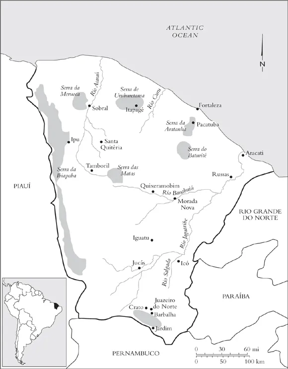
Fig. 1.1. Map of Ceará: Principal Physical Features.
To a large extent, climate and geography conditioned the patterns of colonization and the slow development of agriculture in the region.6 Early efforts by Portuguese settlers and Jesuit missionaries to colonize the captaincy proved fruitless in generating settlements in the dry backlands. Severe droughts and constant Indian attacks obliterated the initial expeditions of the 1610s and 1630s. In the decades following the Dutch occupation of Ceará (1637–44), which also failed to translate into hinterland colonization, a few Portuguese settlers established primitive livestock ranches in the higher margins of the Acaraú and the lower Jaguaribe. Nevertheless, the Tapuia Indians7 successfully impeded their permanent settlement by frequently stealing cattle and attacking the fazendas (large cattle ranches) and their owners. Effective occupation began around the 1670s and 1680s as an outcome of the great expansion of cattle ranching from the backlands of the colonial captaincies of Bahia and Pernambuco. Established cattle raisers from the middle São Francisco River valley who were seeking better or additional grazing lands reached the Parnaiba River basin in southern Piaui and from there moved eastward, into territories belonging to the captaincy of Ceará. By the 1680s, Bahian and Pernambucan cattlemen began setting up ranches along the headwaters of the Jaguaribe and Acaraú rivers, as they sought to take advantage of the várzeas’ natural grasslands.
Central to the colonization of the interior was a generous Portuguese policy of awarding sesmarias (royal land grants) of large dimensions to influential settlers who vowed to use the lands they had conquered to raise cattle and to defend those territories from Indian attacks. The progressive establishment of extensive corrals on lands donated in sesmarias turned the Cearense backlands into an important supplier of cattle. Initially, livestock was transported live in boiadas (cattle drives) to fairs in the sugar plantation regions of coastal Pernambuco and, to a lesser extent, also to those in Bahia. But by the mid-eighteenth century, cattle raisers began establishing oficinas or charqueadas (rustic beef-salting factories) in Cearense ports from which they shipped salted beef and hides to various colonial markets in a more profitable and efficient manner.8
The expansion of the livestock-raising economy facilitated by the continuous award of sesmarias resulted in the creation of a pattern in which large cattle fazendas spread in the sertões (a word that in a restricted sense denotes the pasturelands of river and creek valleys), along with subsistence farming. The serras, or more humid rugged hills, remained mostly unsettled or inhabited by the Indian groups that had managed to survive the intensified warfare practiced against them between the late seventeenth century and the 1720s.9 The colonization of the Cariri valley, situated in the southernmost portion of Ceará, constituted an exception to this overall pattern of settlement. Sugarcane agriculture developed there from the mid-eighteenth century on. Settlers from Bahia took advantage of the permanent irrigation that a series of streams that run downward from the Araripe mountains provided to the valley’s fertile territory and produced cachaça (sugarcane brandy) and rapaduras (brown sugar cakes) from numerous engenhocas (small sugar mills), as well as foodstuffs.10
In a paradoxical manner, the droughts of 1777–78 and 1790–92 stimulated the dawn of commercial agriculture throughout the backlands. The severe drop in cattle production and the consequent disorganization of the salted beef industry that followed the droughts first generated an interest in agricultural activities. Moreover, in the late eighteenth century, the expansion of the British textile industry created a growing demand for raw cotton. Coupled with a 1799 decree that allowed direct trade between the captaincy and Lisbon, the growing demand encouraged the cultivation of cotton—especially its arboreal variety—throughout the interior. Indeed, attracted by the adaptability of arboreal cotton to semiarid as well as humid terrains, its short vegetative cycle, and the relatively low labor intensity it required compared with sugarcane, both large cattle ranchers and the sharecroppers who lived in their lands cultivated the crop in the different Cearense microclimates. By 1810, cotton had spread on the slopes of the Baturité, Uruburetama, Meruoca, and Aratanha mountains, as well as the Jaguaribe River valley, and had become the most significant product for the Cearense economy.11 Even though of short duration (the participation of Brazil in the cotton boom came to an abrupt end in the 1820s, as a result of severe competition from the southern United States), the cultivation of cotton encouraged an expansion in the production of food crops, such as cassava or manioc, corn and beans, and stimulated migratory movements into the hinterland. The available figures indicate that the population of Ceará grew from approximately 61,400 inhabitants in 1782 to 125,800 in 1818.12
The period from the 1820s to the 1840s was marked by decline in the interior. Falling cotton prices in the international market and the devastat ing effects of the drought of 1824–26 severely affected the cattle and cotton economies. Political instability, widespread rebellion, and banditry brought additional hardship and dislocation to the poor inhabitants of the backlands. Nonetheless, the region experienced significant population increase during those years. The available estimates indicate that by the mid-nineteenth century the population of the province as a whole had more than doubled in size from what it had been around the late 1810s. (See Table 1.1.) Much of this demographic growth was concentrated in the backlands rather than the littoral. Roger Cunniff has demonstrated that while the coastal ports of Fortaleza and Aracati increased in population from 12,195 to 16,557 and from 8,100 to 8,805 between 1813 and 1837, the population of the township of Icó, in the upper Jaguaribe River valley rose from 1,258 to 9,307 inhabitants, and that of Crato, in the Cariri valley, from 10,747 to 17,199 persons.13 In particular, the 1825 drought induced further migratory movements, changes in demographic patterns, and an escalating turn toward the planting of ...
Table of contents
- Cover
- Copyright
- Title Page
- Contents
- List of Tables and Figures
- Acknowledgments
- A Note on Weights, Measures, Brazilian Currency, and Orthography
- Abbreviations
- Introduction
- 1. A Brief Moment of Prosperity: Land, Opportunity, and Autonomy, 1845-70
- 2. Unruly Soldiers and Honorable Providers: Paradoxes of Masculinity and State Formation in the Backlands, 1840s-89
- 3. Poor but Respectable: Community, Family, and the Gendered Negotiation of Daily Life, 1845-89
- 4. A Changing World: Deprivation, Dislocation, and the Disruption of Honorable Masculinity, 1865-89
- 5. Masculinity Challenged and Affirmed: Autonomous Women, Men, and Violent Patriarchy, 1865-89
- 6. Of Courage and Manhood: Masculine Spaces, Violence, and Honor, 1865-89
- Conclusion
- Notes
- Bibliography
- Index
Frequently asked questions
Yes, you can cancel anytime from the Subscription tab in your account settings on the Perlego website. Your subscription will stay active until the end of your current billing period. Learn how to cancel your subscription
No, books cannot be downloaded as external files, such as PDFs, for use outside of Perlego. However, you can download books within the Perlego app for offline reading on mobile or tablet. Learn how to download books offline
Perlego offers two plans: Essential and Complete
- Essential is ideal for learners and professionals who enjoy exploring a wide range of subjects. Access the Essential Library with 800,000+ trusted titles and best-sellers across business, personal growth, and the humanities. Includes unlimited reading time and Standard Read Aloud voice.
- Complete: Perfect for advanced learners and researchers needing full, unrestricted access. Unlock 1.5M+ books across hundreds of subjects, including academic and specialized titles. The Complete Plan also includes advanced features like Premium Read Aloud and Research Assistant.
We are an online textbook subscription service, where you can get access to an entire online library for less than the price of a single book per month. With over 1.5 million books across 990+ topics, we’ve got you covered! Learn about our mission
Look out for the read-aloud symbol on your next book to see if you can listen to it. The read-aloud tool reads text aloud for you, highlighting the text as it is being read. You can pause it, speed it up and slow it down. Learn more about Read Aloud
Yes! You can use the Perlego app on both iOS and Android devices to read anytime, anywhere — even offline. Perfect for commutes or when you’re on the go.
Please note we cannot support devices running on iOS 13 and Android 7 or earlier. Learn more about using the app
Please note we cannot support devices running on iOS 13 and Android 7 or earlier. Learn more about using the app
Yes, you can access Cleansing Honor with Blood by Martha Santos in PDF and/or ePUB format, as well as other popular books in History & 19th Century History. We have over 1.5 million books available in our catalogue for you to explore.