![]()
Part I
How to Survive a Tsunami
![]()
Chapter 1
Examples of Tsunamis and Tsunami Disasters
1.1 Case Studies of Actual Tsunami Disasters
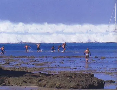
Figure 1.1 shows the tsunami approaching the coast of Thailand and people trying to escape from the tsunami during the Great Indian Ocean Tsunami, which occurred in December 2004. The people in the photograph are trying to escape from it, realizing that the danger is serious. Fortunately, all of these people survived, but did they really understand what was happening at the time, what would follow this scene, and what they should do?
Fig. 1.1 Swimmers fleeing an attacking tsunami (Thailand, 2004).
In order to plan for a smooth evacuation and take effective disaster prevention measures, it is important to understand tsunamis. In particular, each individual must understand the actual damage that tsunamis can cause. For example, if the people in the photograph had understood tsunamis, they would have realized the danger of a tsunami when the sea initially retreated. And if they had understood the damage caused by tsunamis, they would have moved quickly to safety. Even after a tsunami begins to attack, the possibility of survival can be increased by escaping to a nearby high building or other safe place. In other words, an understanding of tsunamis makes it possible to take proper action to avoid danger, and thereby increases the possibility of survival.
Unfortunately, even residents of tsunami-prone regions rarely have direct experience of a tsunami and do not understand the real nature of tsunami disasters. When a tsunami occurs, it can cause terrible damage over a wide region, including heavy loss of human life, as seen in the Great Indian Ocean Tsunami. However, catastrophic tsunamis are very rare. What's more, people from countries which are not prone to tsunami attack (like those in Fig. 1.1) may not even know the word “tsunami.” For this reason, a simulated “quasi-experience” of a tsunami is important, for even this indirect experience can be as effective as a vaccination for preventing disease.
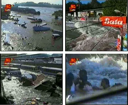
Figure 1.2 shows video images taken in Sri Lanka during the same Great Indian Ocean Tsunami. These images were taken at the bus terminal in the center of Galle, Sri Lanka. The tsunami caused an extremely violent flow in the bus terminal from the left rear. The video shows cars and the remains of houses being carried along by the tsunami and people caught in the current. Images like these were broadcast around the world, and many people saw the terror of tsunamis with their own eyes. In other words, seeing video images of a tsunami is a valuable experience for disaster prevention, even for people far from the actual scene.
However, we must remember that images can only show a very small part of a tsunami disaster. In many cases, TV images show only shocking scenes, and not the whole picture of the tsunami. Explanations of images are also inadequate. Tsunami disasters are quite different, depending on the actual tsunami and the conditions in the area. This means that the tsunamis assumed in each region and the damage they cause will not necessarily be the same as shown in television images. Images of tsunami disasters are valuable and extremely effective in educating people, but it is dangerous to depend only on those images. Therefore, this chapter aims to give the reader a more accurate understanding of tsunamis by describing the real nature of a tsunami disaster, as concretely and scientifically as possible, based on the results of scientific study. The nature and severity of tsunami disasters are determined by the conditions related to the attacking tsunami and the attacked region. The most basic parameter of a tsunami is its height. The basic parameters of the region are its distance from the coast and height above sea level, as well as those of coastal disaster prevention facilities (for example, breakwaters and tsunami control forests), and buildings (type construction, density), and the state of human activities (sleeping, working, commuting to work). While considering these factors, we will try to make the reader feel the reality of tsunamis from the human perspective, utilizing photographs where possible.
Fig. 1.2 Violent flow caused by an attacking tsunami (Sri Lanka, TV).
When reading each section, the reader should remember that the explanation is given for a certain height of tsunami. This is done to clarify the relationship between the height of the tsunami and the nature and degree of damage, because the magnitude of a tsunami is represented by its height. Therefore, if you can estimate the height of a tsunami attacking your region, you can form a specific image of the possible damage in your area by referring to the examples in each section. Forecasts of tsunamis for alerts and warnings currently use the height of the tsunami as a standard, as shown in Table 1.1, that is, warnings say “an x-meter tsunami is forecast.” It is possible to imagine how large a tsunami attack will be and how much damage will occur by comparing with the damage examples in each section, and to predict expected damage and make evacuation plans based on this information.
Table 1.1 Standards for tsunami warnings and alerts.
| Type of forecast | Typical announcement | Height of tsunami (in meters) |
| Tsunami alert | A tsunami with a maximum height of 0.5 m is forecast; caution is advised. | 0.5 |
| Tsunami warning | A tsunami with a maximum height of 2 m is forecast; extreme caution is advised. | 1 or 2 |
| Large tsunami warning | A tsunami with a maximum height of 3 m or higher is forecast; extreme caution is advised. | 3, 4, 6, 8, 10, or higher |
1.2 Indian Ocean Tsunami Disaster
(1) Outline of the earthquake and tsunami, and resultant disaster
(1) Occurrence of the earthquake and tsunami
An earthquake with a magnitude of M9.3* occurred on December 26, 2004 at 0:58 GMT (Greenwich Mean Time; 7:58 in the morning in the local time of Indonesia and Thailand, and 6:58 in Sri Lanka). The occurance of the earthquake was captured by seismographs around the world, and general estimates of the focus and magnitude were given immediately by meteorological agencies in Japan, the United States, and other countries. The focus was the sea bottom (latitude 3° N, longitude 96° E, depth 30 km) approximately 10 km northeast of Pulau Simeulue (Simeulue Island) off the coast of the Island of Sumatra, Indonesia. The rupture of the earth's crust which caused the earthquake propagated to the Nicobar and Andaman Islands to the north, reaching a total length of about 1,000 km. This was a trench-type earthquake, which causes large-scale tsunamis. It occurred in the earthquake-prone region where the Indo-Australian Plate subducts under the Eurasian Plate. The magnitude was extremely large, even from a global viewpoint, and was the fourth largest since 1900 (the largest was the M9.5 Chilean Earthquake of 1960).
(2) Propagation of the tsunami
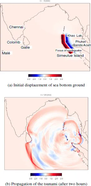
In order to understand the disaster caused by this tsunami, first, it is necessary to know how it spread from the focal area, propagating through the open sea, and attacked the coasts of countries around the Indian Ocean. The propagation of the tsunami can be seen in numerical simulations by a computer. Figure 1.3 shows the results of such simulations. (a) shows the estimated location where the sea bottom ground rose and fell due to the rupture of the earth's crust. The areas in red are where the seabed rose. The average height of the rise was approximately 2 m. Blue shows areas that sank, the average drop being from -0.5 m to -1.0 m. Banda Aceh, which is on Sumatra near the focus of the earthquake, sank. This deformation of the seafloor shape was transmitted unchanged to the sea surface, where it caused a corresponding deformation that resulted in the tsunami. Figure 1.3(b) shows the tsunami two hours after the earthquake. Because the energy of a tsunami spreads and weakens with distance, the height of the tsunami decreases as it propagates over long distances. The direction and height of the tsunami also change due to the topography of the sea bottom, and the tsunami becomes more complex due to reflection by land and islands. In the open sea, the height of a tsunami is normally less than 2 m. Because this is small in comparison with its length that reaches several 100 kilometers, it is difficult for human observers to recognize a tsunami, and the effect on ships is extremely slight. However, after a tsunami propagates across the open sea, its height increases when it approaches the coast as the water becomes very shallow. As a result, the tsunami causes damage on the coastline. A tsunami is also affected by the topography of the sea floor (through various effects such as refraction, diffraction, and energy concentration), and the wave height and direction vary greatly, depending on the place. Damage also differs, depending on these conditions.
Fig. 1.3 Example of numerical simulation of the Great Indian Ocean Tsunami (Tomita et al., 2005).
(3) Tsunami attack
At Banda Aceh in northern Indonesia, near the focus of the earthquake, the tsunami attacked less than 20 minutes after the earthquake. The height of the tsunami (trace height or run-up height: a maximum height of a tsunami onshore above sea level) was 4-8 m in districts facing north, but was as large as 10-20 m in districts on the west, which faced the focus of the earthquake. The average water depth of the ocean between the seismic focus and Thailand is relatively shallow, at approximately 400 m. As a result, the propagation velocity of the tsunami was also comparatively slow, being on the order of 200 km/h. In Thailand, the tsunami run-up height was 4-10 m in the vicinity of Khaolak and further to the south, 4-6 m around Phuket. A notable point is that because the sea bottom ground facing Thailand dropped, the tsunami attack on the Thai coast began with a “backwash” (water pulling back from the normal shoreline). On the other hand, the ocean depth between the focus of the earthquake and Sri Lanka was deep, averaging approximately 4,000 m. As a result, the speed of the tsunami was extremely fast, at about 700 km/h, and the tsunami propagated over a distance of about 1,200 km in a little more than 100 minutes. The fundamental period of this tsunami was 40-50 minutes, and its wavelength was several 100 km. In Sri Lanka, the height of the tsunami was 5-10 m on the eastern coast and 4-10 m on the southern coast. Because the sea bottom ground around the earthquake focus facing Sri Lanka rose, the tsunami attack on the Sri Lanka coast began with a rising wave. The tsunami also propagated to India and the islands of the Maldives, and even reached far-away Somalian coast in Africa causing damage. In these regions, the tsunami attacked repeatedly, and in many cases, not the 1st wave, but the 2nd or later wave was the largest. However, in Bangladesh, which is located along the axis of the displacement of the sea bottom ground, the height of the tsunami was not particularly great.
(4) Human damage due to the tsunami
The Indian Ocean Tsunami resulted in a very large number of deaths and missing persons (Table 1.2), totaling around 300,000 persons. In general, a disaster which causes around 10,000 deaths is called a “catastrophic disaster.” The Indian Ocean Tsunami far exceeded this standard, and was one of the worst disasters in recent history. The following three reasons can be given for this enormity of the disaster.
(1) A giant earthquake caused an extremely large tsunami which attacked many regions, including remote countries. Because the earthquake tsunami was caused by a giant trench-type earthquake, a large tsunami with a height exceeded 4 m attacked many regions. Heavy damage, including destruction of buildings occurred in areas where the tsunami exceeded 4 m. Areas where the tsunami was 8 m to over 10 m were basically wiped out.
Table 1.2 Deaths and missing by country.
| Indonesia | 256,000 |
| Thailand | 5,400 |
| Sri Lanka | 38,000 |
| India | 10,750 |
| Maldives | 80 |
| Somalia | 300 |
(2) The tsunami suddenly attacked the people who did not know that a large earthquake had occurred and also did not receive any warning in advance. Collapse of buildings and other earthquake damage occurred...