![]()
How Can We Escape a Tsunami?
![]()
Chapter 1
Examples of Tsunami Disasters
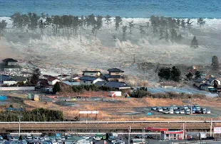
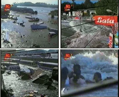
A gigantic tsunami was generated by the Great East Japan Earthquake on March 11, 2011. Fig. 1.1 is a photograph of the tsunami attacking the coast of Sendai bay, Japan. The tsunami exceeding 10 m in height caused devastating damage to the coastal area. The fact that nearly 20,000 persons were lost by the tsunami is both shocking and regrettable in the extreme.
The authors think that “Tsunami disaster prevention begins with each individual citizen knowing the actual severity and damage caused by tsunamis and imagining that damage.” When we consider how people evacuate from a tsunami, it is fundamental and essential that each of them knows well about tsunamis, and in particular, has accurate knowledge of the actual damages caused by a tsunami. If people know well about tsunamis and the actual disasters they cause, perhaps they will consider evacuating at an earthquake, and will surely evacuate at the issue of a tsunami warning. Even if a warning is not noticed, perhaps they will sense the danger of a tsunami and evacuate when the sea begins to recede abnormally. Even if they are run after by a tsunami of high speed, they will save their own lives more possibly by fleeing to a nearby tall building or other safe place. In other words, if people know well about tsunamis and tsunami disasters, the possibility of survival from the tsunami is made lightly higher by taking a proper action to escape the danger.
Fig. 1.1 Tsunami attacking from the coast (Natori City, Miyagi Prefecture; Mainichi Shimbun)
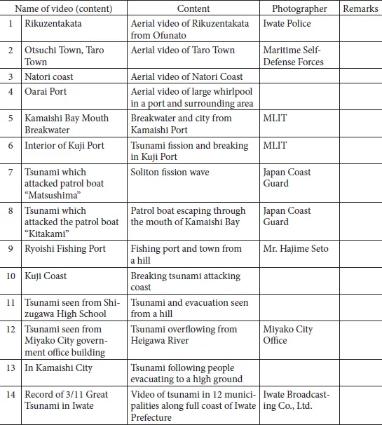
Past tsunami disasters are most effective to understand the damage that tsunamis actually cause. Although they are actually misery, they can be considered as valuable experience that should be passed on to the future. Many photographs and videos were taken for the Great East Japan Earthquake Disaster, and in particular, for the tsunami attack. Those precious images have been shown not only in Japan but also in other countries around the world, and many people could see the terror of the tsunami with their own eyes. In other words, people far from the actual sites of the tsunami disaster have had the vicarious experiences of the tsunami through video images, and this experience has become invaluable for disaster prevention. Table 1.1 is a list of important videos taken at the 2011 tsunami attack. Table 1.2 is a list of the main collections of photographs of the tsunami disaster.
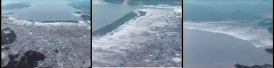
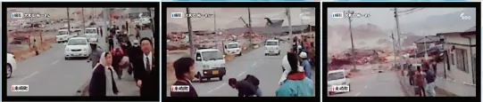
Figs. 1.2 to 1.4 are still images from videos taken in the sites of the Great East Japan Earthquake Disaster. Fig. 1.2 taken by the Iwate Prefectural Police, shows the tsunami attacking Rikuzentakata. First, the tsunami attacked Hirota Bay in front of Rikuzentakata, second overflowed the coastal seawalls and Takata-Matsubara, and finally attacked the hinterland. It continued to advance further toward inland, and reached the foot of a height 2 km far from the coast. The height of the tsunami exceeded 15 m. Fig. 1.3 shows images taken in the Yonesakicho area of Rikuzentakata. Here, the tsunami is chasing people in the process of evacuation, and carrying a large amount of debris with it.
Fig. 1.4 shows images from a video taken in Sri Lanka at the Indian Ocean Tsunami and not at the Great East Japan Earthquake. This video was taken at a bus terminal in the center of Galle. An extremely violent flow caused by the tsunami can be seen from the left rear in the video toward the bus terminal, and is carrying the wreckage of houses, automobiles, and other large debris. The scene of people engulfed in the flow is faithfully reproduced in this image.
However, it must be noted that videos show only a very small part of a tsunami disaster. In particular, the televised images shown on TV, etc., frequently only pick up shocking scenes and do not show the total image of the tsunami, and in some cases, the explanation of the images is also insufficient. Moreover, tsunami disasters differ greatly, depending on the conditions of the individual tsunami and the region. For this reason, the tsunamis assumed in various regions and the disasters caused by those tsunamis, will not necessarily be the same as those in such images. Video images of tsunami disasters are precious documents and are extremely effective for educating people who may be at risk of a tsunami, but it is dangerous to depend only on those images. Therefore, the aim in this chapter is to enable all readers to have a more accurate vicarious experience of tsunamis by describing the actual conditions of tsunami disasters as concretely and scientifically as possible, based on the results of scientific studies. The conditions which determine the state and degree of tsunami disasters are divided into two factors of the attacking tsunami and the attacked area. The most basic factor of a tsunami is its height. The basic factors of the area are the height above sea level, the distance from the coast line, the existences of coastal disaster prevention facilities and buildings, and the state of people’s activities. Considering those factors, we will also try to provide a description which allows many people to experience the real fear of tsunamis as the human feeling by inserting as many photographs as possible in this book.
Table 1.1 Valuable videos of tsunami attack (list)
Table 1.2 Main photo collections of tsunami disaster
| Title | Publisher |
| Nikkei Construction, Great East Japan Earthquake Disaster | Nikkei Business Publications, Inc. |
| Sunday Mainichi, emergency special edition, Great East Japan Earthquake Disaster | Mainichi Newspapers |
| Special news photo collection, 3/11/2011, Complete Record of One Month | Kyodo News/Niigata Nippo |
| Complete news record, 3/11 to 4/11, 2011, Great East Japan Earthquake Disaster | Asahi Shimbun Publications, Inc. |
| M9.0 Great East Japan Earthquake Disaster, 30 Days of Fukushima | Fukushima-Minpo Co., Ltd. |
| Great East Japan Earthquake Disaster, Complete Record of One Month, Fighting Japan | Sankei Shimbun Publications, Inc. |
| Great East Japan Earthquake Disaster, Yomiuri Shimbun News Photo Collection | Yomiuri Shimbun Tokyo Head Office |
| Record of Giant Tsunamis of Meiji, Showa, and Heisei Eras | Mainichi Newspapers |
| Great East Japan Earthquake Disaster, Complete Record of 1 Month | Iwate Nippo Co., Ltd. |
| Complete Record of Great East Japan Earthquake Disaster — Reports from the Disaster Area | Kahoku Shimpo Publishing Co. |
| The Great East Japan Earthquake and Tsunami | Kahoku Shimpo Publishing Co. |
| Attack of Great Tsunami: Record of Ishinomaki Area | Sanriku Kahoku Shimpo Publishing Co. |
| Record of Before/After the Tsunami Disaster: A Collection of Aerial Photographs of Miyagi, Iwate, and Fukushima Prefectures | Kahoku Shimpo Publishing Center |
| Aerial photo collection: Landscape of Memories — The Seashores of Miyagi | Kahoku Shimpo Publishing Center |
| Complete Record of Great East Japan Earthquake Disaster — Reports from the Disaster Area | Kahoku Shimpo Publishing Center |
| News photo collection, The Disaster of 3/11 When the Giant Tsunami Attacked | Kahoku Shimpo Publishing Center |
| Special news photo collection, The Heisei Sanriku Great Tsunami: A Record of the Great East Japan Earthquake Disaster in Iwate Prefecture | Iwate Nippo Co., Ltd. |
| The Great East Japan Earthquake Disaster in Maps — Great Earthquake, Fukushima Nuclear Power Plant and Prediction of Disasters | Seibido Shuppan Co., Ltd. |
Fig. 1.2 Tsunami attacking Rikuzentakata (photographed by Iwate Prefectural Police)
Fig. 1.3 Scenes of evacuating people in Rikuzentakata (photographed by Mr. Yuichi Owada, Iwate Broadcasting Co., Ltd.)
Fig. 1.4 Violent flow caused by attacking tsunami (Sri Lanka: TV)
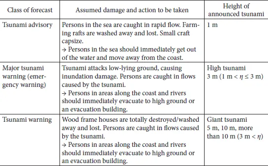
Table 1.3 System of tsunami advisories and warnings in Japan
Note: η denotes the height of tsunami.
When reading each section, the reader should be aware that the explanation notes the height of the incident tsunami in order to make the relationship between the tsunami height and the intensity of the disaster clearer. Because the size of attacking tsunamis is generally shown by the tsunami height, readers can form a concrete image of the damage in their own regions by reading the damage description due to the tsunami which has almost same height as the attacking tsunami assumed in the regions. As shown in Table 1.3, at present, tsunami forecast for advisories or warnings is issued fundamentally as tsunami heights in meters. For example, “Tsunami of X m high is attacking.” An image of the degree of damage caused by a tsunami of a certain size can be formed by comparing the concrete examples in the respective sections, and should provide a useful reference to readers when they consider the expected damage and their own evacuation actions.
References
Sanriku Kahoku, Inc. “Ishinomaki Kahoku” Editorial Office: Surviving the 2011 Tsunami: 100 Testimonies of Ishinomaki Area Survivors of the Great East Japan Earthquake, Junposha, p. 266. (English ed.)
Takahashi et al. (2011): Urgent Survey for 2011 Great East Japan Earthquake and Tsunami Disaster in Ports and Coasts, Technical Note of the Port and Airport Research Institute, No. 1231, p. 200.
Nissho (2012): The Struggle of the Fire Brigades — The 3.11 Great East Japan Earthquake (Kindai Shobosha), p. 310.
![]()
1.1The Great East Japan Earthquake and Tsunami Disaster
(1)Outline of the earthquake and tsunami, and damage caused
At approximately 2:46 p.m. on March 11, 2011, a subduction zone type giant earthquake with a magnitude of 9.0 (hereinafter, M9.0) occurred at a depth of 24 km at east longitude 142.9° and north latitude 38.1° in the Pacific Ocean off the Sanriku coast of Japan, causing enormous earthquake and tsunami damage centering on eastern Japan. Nationwide, the total number of dead and missing persons was almost 20,000. Because this tsunami was extremely large, and also greatly exceeded the tsunamis that had been assumed until that time, it caused catastrophic damage. In many areas, the attacking tsunami overwhelmed tsunami defense facilities, and the damage expanded as a result of the destruction of those facilities (Port and Airport Research Institute, 2011, Takahashi, 2011). The Great East Japan Earthquake Disaster is essential for understanding the actual condition of damage in a tsunami of the largest class. This disaster led to a renewed recognition of the importance of protecting lives and mitigating damages by considering the worst case scenario.
1)Occurrence of earthquake and tsunami
During this earthquake, violent ground motion continued for more than 3 minutes. Seismic intensity of 7 was observed in Kurihara City, Miyagi Prefecture, and seismic intensity of 6-upper was observed in Fukushima Prefecture, Ibaraki Prefecture, and Miyagi Prefecture. Seismic intensities of 1 and higher were also observed over a wide area extending from Hokkaido to Kyushu. However, the damage due to the earthquake ground motion was comparatively small, while the damage caused by the tsunami was overwhelmingly large.
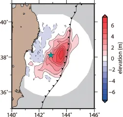
Fig. 1.5 shows the estimated tsunami source area (spatial waveform of tsunami at time of occurrence) (Takagawa, Tomita, 2012). The figure also shows the estimated vertical displacement of the seabed caused by the earthquake. It can be understood that upheaval/subsidence occurred over an extensive area of the sea bottom measuring 500 km × 200 km. In particular, it is estimated that large displacement occurred around the trench, and this is considered to be one cause of the giant tsunami. The tsunami generated at this trench area caused a distinctive waveform, in which a comparatively short period tsunami of around 10 minutes was superimposed on a long period one of about 50 minutes. Displacement was generated from the epicenter and then spread to the vicinity of the trench during about 3 minutes. It should also be noted that the ground subsidence around 1 m occurred along the Sanriku coast.
Fig. 1.5 Estimation of tsunami source area (Takagawa, Tomita, 2012)
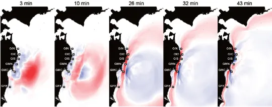
Fig. 1.6 Results of calculation of tsunami propagation (Takagawa, Tomita, 2012)
2)Propagation of tsunami
Fig. 1.6 shows the calculation results of the tsunami propagation (Takagawa, Tomita, 2012). The figure shows tha...