![]()
1
Prelude to the History of the Chinese in Singapore
Kwa Chong Guan
Abstract
It was, this chapter argues, a millennium-old Hokkien trading world in the South China Sea which provided the context and the foundations for the arrival of a community of Hokkien merchants to help start the British station Stamford Raffles established on Singapore, and the subsequent development of a Chinese community in Singapore. With a homeland which is “eight parts mountains, one-part water and one-part farmland” the Hokkiens had to turn to the sea “as their farmland they ploughed.” From the time of the Ming dynasty, if not earlier, the Hokkien traders formed sojourning communities through the South Seas. 19th-century Singapore was another such sojourning community.
Stamford Raffles, on his second visit to Singapore at the end of May 1819, wrote to Charlotte Seymour, Duchess of Somerset that:1
… my new Colony thrives most rapidly – We have not been established four months and it has received an accession of Population exceeding five thousand souls, principally Chinese and their number is daily encreasing; it is indeed with difficulty we find room for them – Native and other vessels from all parts of the East already frequent our Harbour, and if the authorities at home only confirm and support what I have done, Singapore bids fair to become the great commercial Emporium of this part of the World…
Among the Chinese Raffles may be referring to were merchants from Malacca and Penang, notably the leading merchants Tan Che Sang (陈送) and Choa Chong Long (蔡沧浪), the artisans and craftsmen who came with them to build the godowns along the Singapore River, and also itinerant hawkers and peddlers like Tan Tock Seng (陈笃生).
The arrival of these prosperous Chinese merchants raises the critical question of the circumstances enabling Tan Che Sang, Choa Chong Long and others described in Song Ong Siang’s (宋旺相) classic One Hundred Years’ History of the Chinese in Singapore to make their fortunes which they brought to Singapore. Tan was a reclusive merchant who was addicted to gambling. He left his home in Fujian in 1778 when he was 15 and made his fortune trading in Riau, then Penang for 10 years, before moving to Malacca. There he responded to Major William Farquhar’s call to relocate to Singapore, where he remained till his death in 1836. Choa, in contrast, was born in Dutch Malacca, the son of a Kapitan China, who rose to head the Hokkien bang in Singapore and reached out to actively interact with the British community in Singapore. He was tragically murdered by burglars in Macau when he was en route to China in 1836.
Seah Eu Chin (佘有进), in an often-quoted comment on the Chinese in Singapore,2 separated these “Malacca-born Chinese” from other more recent immigrants from the “Hokkien province”. Seah in 1848 estimated this group of Malacca Chinese to be about 1,000, compared to 9,000 other Hokkiens, 19,000 Teochews, 6,000 Cantonese, 4,000 Hakkas and 700 Hainanese. Seah does not mention it, but an earlier generation of these 19,000 Teochews were in Singapore before Raffles arrived, cultivating gambier and pepper.3 Seah eventually rose to be the “gambier and pepper king” and the leader of the Teochew (潮州) community.
Seah enumerated that this group of 1,000 “Malacca-Chinese” men comprised 300 “Merchants and shopkeepers and their people”; 100 “Cash keepers and other employed by Europeans”; 300 “Householders employed variously”; 200 “Petty traders”; and finally, 100 “Agriculturists”. As merchants, Tan Che Sang and all the other Malacca-born Chinese would be dependent upon a network of personal connections, social institutions and trade routes forming trading networks to conduct the trade from which they derived their wealth.
This chapter seeks the beginnings of these trade routes that formed the trading networks which enabled Tan and his compatriots to accumulate their wealth, which they brought to Singapore with them in 1819.
The Selden Map
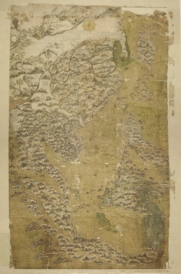
A starting point to understanding the trade routes and trading networks which formed the trading world of Tan Che Sang and his kinsmen is found in a singular Chinese map donated to Oxford University’s Bodleian Library by the English jurist John Selden, who is best known as the author of the 1619 treatise Mare Clausum (“The Closed Sea”) challenging the tract Mare Liberum (“The Open Sea”) by the Dutch jurist Hugo Grotius. It was perhaps because of this interest in the rights to maritime trade that Selden, an Orientalist with a working knowledge of several Asian languages, acquired this map which he willed to the Bodleian Library. The map arrived at the Bodleian Library in 1659, after Selden’s death in 1653, and was largely forgotten until 2008 when the American historian Robert Batchelor retrieved it.4
Unlike other Chinese maps which is centred on the Chinese mainland and with the China Seas on its periphery, the 1.5m x 0.96m Selden map is centred on the South China Sea. It is drawn according to early modern European cartographic standards but uses Chinese landscape painting techniques to outline mountain ranges, rivers and ocean waves, rendering the map a landscape painting of sorts.
The key feature, and significance of this map, is the 60 or more ports marked on the map and connected by sailing routes that start from a port south of Quanzhou and Zhangzhou (
漳州), probably Yuegang (
月港, Moon Harbour). One principal route goes northeast towards Nagasaki and another extends southwest towards the Vietnamese port of
An and on to the Malay Peninsula. What is significant is the branch route leading towards Johor, where it then further branches out into sub-routes up the Malacca Straits; another route branches south along the Sumatran coast to the Sunda Straits and westwards along the Java coast. Another sub-route leads northeast-wards to Borneo and on to Manila, while yet another sub-route
reaches out to eastern Indonesia. Instructions are written next to these routes, indicating compass directions for the route. These compass directions and the geographic knowledge incorporated in the map continue to be debated.
5 The Selden Map of China, courtesy of the Bodleian Library, University of Oxford.
There is no information to when the map was drawn, or by whom and on whose instructions.6 The consensus emerging from Batchelor and other scholars who have examined the map is that it was almost certainly drawn no earlier than 1606 and no later than 1623. This consensus is based on the style of the calligraphy and the transcription of the place names which suggests the map was probably drawn in Nagasaki but could also have been drawn in Banten or even Manila where there were major Hokkien communities. The map was probably commissioned by a leading Hokkien merchant for his reference or display. There are only speculations on how the map moved from Nagasaki or Banten to London and into the Library of John Selden.
The contents of the Selden map and the probable circumstances of its creation suggests that it depicts the maritime trading world of the Hokkien merchants at the beginning of the 17th century.7 The significance of the map is that it depicts the trading routes and trade networks which Tan Che Sang and Choa Chong Long were born into and carried to Singapore in 1819.
The Hokkien Trading World
The momentum driving the Hokkiens to turn to the East and to the South China Sea for their livelihood as traders was their environment. The Hokkien description of their homeland as “eight parts mountains, one-part water and one-part farmland” sums up well why the Hokkiens had to turn to the sea “as their farmland they ploughed”. The mountainous terrain of Fujian was also a barrier to northern Chinese migration into the region until the Tang ushered in a cycle of economic development and foreign trade via what has since become known as the “Silk Roads” across Eurasia, the Indian Ocean and the South China Sea.
Canton (Guangzhou), Fuzhou and Quanzhou developed as the ports designated by imperial policy to receive foreign traders seeking entry into China’s markets under the Tang and to administer a growing coastal trade.8 The Kingdom of Min (909 C.E.–945 C.E.) which controlled Fuzhou and ruled the Min river valley at the end of the Tang dynasty marked a new cycle of the economic history of Fujian, with new patterns of demographic growth driving urban growth and its interrelation with maritime trade and domestic commerce.9
Fujian’s economic structure become more integrated under the Song from 978 C.E., with the development of an articulated network of markets, commercialisation of the agricultural sector and development of local industries, especially ceramics and metalworking. Quanzhou became the emporium10 where the foreign trade of the Nanhai (South Sea) interfaced with the domestic trade networks from 1000 to 1400 C.E.
The South China Sea and its trade formed a distinct trading world dominated by Quanzhou and was linked to the Bay of Bengal, which formed another distinct trading world that was linked at Sri Lanka to the trading world of the Arabian Sea of the Western Indian Ocean.11 The integration of these three maritime trading worlds between the 10th to the 13th centuries created in effect a precursor of the capitalist world economy eventually established by Europe.12 However, a 14th century crisis precipitated in part by the collapse of the Yuan in 1368 as a consequence of climate changes and a plague pandemic collapsed the Nanhai trading world. Concurrently another plague pandemic ravaged Europe as the “Black Death” spread to West Europe, causing trade across the three trading worlds of the Indian Ocean and the South China Sea to slump.
Fourteenth-century Singapore was a victim of this crisis.13 Archaeological excavations on Fort Canning and its environs since 1984 have recovered several tons of artefacts, principally local earthenware, a variety of Fujian and Guangdong stoneware jars for packing and transporting of various cargoes, and high-value ceramics, including newly-developed blue-and-white porcelains from the Jingdezhen kilns. This archaeological evidence points to Singapore’s rapid emergence as a regional trading centre distributing Chinese manufactured products to the Malay world at the beginning of the 14th century. The Quanzhou trader and traveller Wang Dayuan reported that in around 1330 there were two settlements he knew as Danmaxi (单马锡, Temasek) and Banzu (Fort Canning) in the Longyamen straits (龙牙门, Dragon’s Tooth Strait) where local products from hornbill casques to Lakewood were traded alongside porcelains and iron pots and textiles which, Wang tells us, were obtained from Quanzhou traders. Intriguingly, Wang observed that the “natives and the Chinese dwell side by side”, suggesting a community of Chinese merchants resident in Temasek.
The archaeological evidence however indicates that both Temasek and Banzu were abandoned or declined as regional entrepôts towards the end of the 14th century, concurrent with the decline of Fujian maritime trade and prosperity when the Yuan lost the mandate of heaven to rule to the Ming in 1368.
A new trading world emerged in the South China Sea in response to Ming imperial policies towards foreign trade.14 The dilemma was the Ming’s Confucian ideological preference for foreign trade to be managed as public trade — offered a...